Nevejski preval / Sella Nevea - Monte Cregnedul (unmarked mule track)
Starting point: Nevejski preval / Sella Nevea (1176 m)
| Latitude/Longitude: | 46,3908°N 13,4755°E |
| |
Route name: unmarked mule track
Walking time: 3 h 45 min
Difficulty: partly demanding unmarked way
Elevation gain: 1175 m
Elevation difference along the route: 1175 m
Map: Tabacco 019 1:25000 ali Julijske Alpe -Zahodni del (PZS) 1:50000
Recommended equipment (summer): helmet
Recommended equipment (winter): helmet, ice axe, crampons, lamp
Views: 12.789
 | 4 people like this post |
Access to starting point:
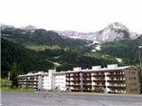
A) Through the border crossing Rateče we drive to Trbiž / Tarvisio. Just before Trbiž we turn left towards Predel or Bovec and follow the road to the crossroad before Rabeljsko jezero lake. Here we continue right towards Nevejski preval / Sella Nevea. On the saddle, we can park on a macadam parking lot below the smaller ski slope on the right, Viški side.
B) From Bovec over Predel we descend to the Italian side. Just a little after Rabeljsko jezero lake at the crossroad we continue left towards the saddle Sella Nevea / Na Žlebeh.
C) From the road between Videm and Trbiž in the settlement Kluže / Chiusaforte we turn into the Reklanica valley to the pass, past the lower station of the gondola cableway and the turn-off for mountain pasture Pecol to the ski slope on the left side of the road.
Route description:
By the road, we will notice several signposts, which mark path 625 towards the mountain hut Corsi. We ascend by the ski slope on a poorly beaten footpath which brings us to a macadam road which is ascending on the right side of the ski slope. For some time we are then ascending on the road, and then blazes point us to the left into the forest. After a short ascent, we come to a crossroad, where we continue right on the path 625, and left a path branches off towards the mountain pasture Krni dol / Cragnedul and further towards Pecol and mountain hut Brazza. The path is then still ascending through the forest and brings us to a crossroad, where another path branches off to the left, which leads towards the nearby mountain pasture. At the altitude of 1624 m we encounter ruins. Here we leave the marked path 625, which runs right further towards the saddle Passo degli Scalini (2022 m), and we follow a well-beaten path – mule track into the slopes below Špik nad Špranjo / Modeon del Buinz and later into the side ridge Planota. Unmarked path gently zig-zags over extensive grassy slopes, where in the summer it is a real heaven for lovers of flowers and photographers, and usually there are also many ibex. The mule track brings us to the side ridge, crosses it and along it by the remains of military structures brings us to Krnidolska škrbina (around 2320 m), from where the nearby peak is easily accessible. Right below the notch is a cavern with a window. On the notch our path joins the marked ferrata Ceria-Merlone, on which we can to the right via ladder descend into Škrbina Prednje špranje and to the mountain hut Corsi below Viš, to the left it starts an almost horizontal crossing of ledges, which brings us in less than half an hour to Špica v Planji (2411 m), later also below the sharp ridge of Nižnjih vrhov to the notch La Val, Špik nad Špranjo (2558 m) and Špik nad Nosom (2531 m).
Right from the cavern we look for the easiest passages and in a couple of minutes we reach the panoramic summit. On it there is a larger cairn.
Pathless ascent to the summit (3 minutes) is one level harder than walking on the partly ruined mule track.

Along the route: Planina Krni dol /Casere Cregnedul di sopra (1511m), ruševine (1624m), Krnidolska škrbina (2320m)
Photos:
 1
1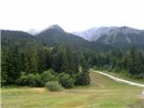 2
2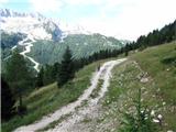 3
3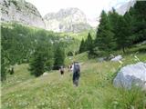 4
4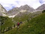 5
5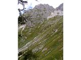 6
6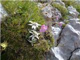 7
7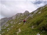 8
8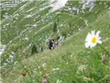 9
9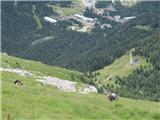 10
10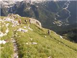 11
11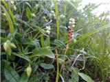 12
12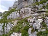 13
13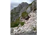 14
14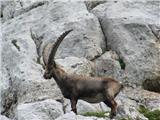 15
15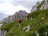 16
16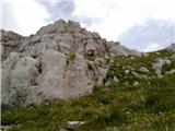 17
17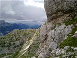 18
18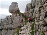 19
19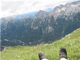 20
20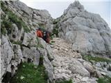 21
21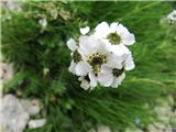 22
22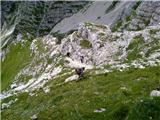 23
23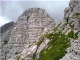 24
24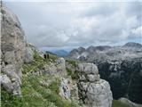 25
25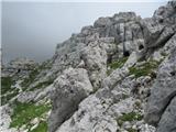 26
26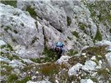 27
27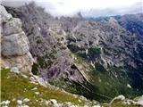 28
28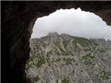 29
29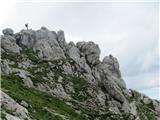 30
30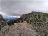 31
31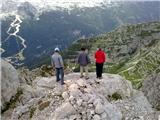 32
32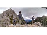 33
33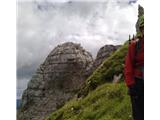 34
34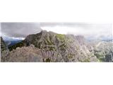 35
35
Discussion about the trip Nevejski preval / Sella Nevea - Monte Cregnedul (unmarked mule track)
|
| damijanp16. 08. 2011 |
Last week, when there was a crowd on most paths, we set off on this trip. In short: peace, wonderful nature, chamois, flowers ... and solitude, as we met no one (from the junction for VKD at the ruins). In short, balm for the soul. Highly recommended.
Pictures are at the following link:
Vrh Krnega Dola
|
|
|
|
| darinka415. 06. 2022 06:07:02 |
We were there yesterday. On new unknown paths. Because none of us had been up here before. We didn't meet anyone except ibexes. We took time to view the remains from the First World War. The day wasn't sunny. Quite some cloudiness. It opened and closed. It didn't bother us at all. We had curious looks from ibexes on the path. Also at the summit. Old ones, young ones, mothers with young. They have their peace here. We stayed at the summit for quite some time. Then the sky opened and we had views. We descended the same path. At the end we stopped by Rabeljsko Lake. And the two of us with Renato swam. A day as one could wish for.
|
|
|
|
| darinka48. 07. 2023 16:23:33 |
Now I understand better what the trails there look like. This trail from Žlebi isn't marked with numbers. But there's a branch to Corsija with 656, hope I didn't mistake. From the summit we descended via the climbing trail. For that we needed a via ferrata set. The cables seem newly installed. No pitons either. You find footholds in the rock. Where the cables end there's still the only snowfield to cross. Then part of the trail goes over scree to the trail over sedlo Scallini, where we reached the starting point. Looks like no one has walked this side yet. Except chamois.
|
|
|
|
| mirank9. 07. 2023 07:37:38 |
If the trail has a number on the middle field it means that a certain CAI, PZS in our terms, takes care of the perfect markings and protections.
|
|
|
To post a comment you must log in:
If you do not yet have a username, you must first
register.