Scicchizza - Lake Zgornje Mangartsko jezero
Starting point: Scicchizza (857 m)
| Latitude/Longitude: | 46,4819°N 13,6749°E |
| |
Walking time: 20 min
Difficulty: easy marked way
Elevation gain: 72 m
Elevation difference along the route: 95 m
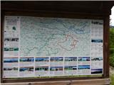
Map: Julijske Alpe - zahodni del 1:50.000
Recommended equipment (summer):
Recommended equipment (winter):
Views: 13.519
 | 2 people like this post |
Access to starting point:
A) First, we drive to Kranjska Gora, and then we continue driving towards Rateče and further into Italy. When we arrive in the settlement Fužine / Fusine in Valromana, we will notice signs immediately after crossing the Jezerski potok stream for Mangartska jezera / Laghi di Fusine (by the road there are signs in Italian). We continue left in the mentioned direction and continue driving on a narrower asphalt road, which we follow to the hamlet Scicchizza. We park on the parking lot by the road, immediately after a cycling road joins us from the left.
B) Via the Predel border crossing we drive into Italy, and then we continue driving towards Trbiž / Tarvisio and further towards Rateče. When we arrive in the settlement Fužine / Fusine in Valromana, we will notice signs just before the road crosses the Jezerski potok stream for Mangartska jezera / Laghi di Fusine (by the road there are signs in Italian). We continue right in the mentioned direction and continue driving on a narrower asphalt road, which we follow to the hamlet Scicchizza. We park on the parking lot by the road, immediately after a cycling road joins us from the left.
Route description:
At the end of the parking lot, we notice a nicely arranged tourist path, which branches off slightly to the right from the road. The pleasant path continues along the Jezerski potok stream and leads us in a gentle to moderate ascent past several stronger karst springs. Higher up, we arrive at a junction at the small dam of Spodnje Mangartsko jezero lake, where we continue left to the nearby road (right snack bar and nice viewpoint from the lake towards Mangart). For a short time we continue directly between the road and the lake, then only along the lake. On the other side of the lake the path splits, and we continue straight in the direction of Zgornje Mangartsko jezero lake (right path leads circularly around the lower lake).
We continue on a cart track, which turns into forest and turns right. On this section the cart track temporarily ascends steeply, then levels out and brings us to the next junction, this time near the climbing area. Here we continue left, then we gradually begin to descend. After a short descent, we arrive at Zgornje Mangartsko jezero lake and viewpoint on the surrounding mountains.
Description and pictures refer to the condition in the year 2015 (June).

Photos:
 1
1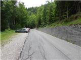 2
2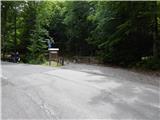 3
3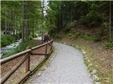 4
4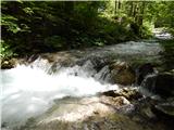 5
5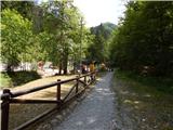 6
6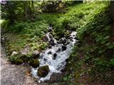 7
7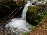 8
8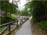 9
9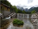 10
10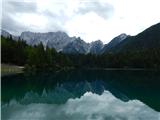 11
11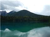 12
12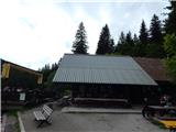 13
13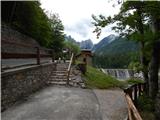 14
14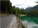 15
15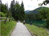 16
16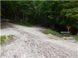 17
17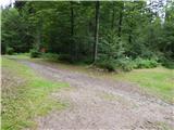 18
18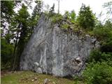 19
19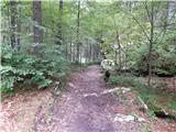 20
20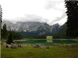 21
21
Discussion about the trip Scicchizza - Lake Zgornje Mangartsko jezero
|
| Gost28. 09. 2006 |
The lower lake is well maintained, the upper one is more like a large puddle. At least at the end of September it was like that.
|
|
|
|
| seinfeld26. 08. 2016 |
We were there yesterday, I would add my route suggestion.
You can drive by car right to the lower lake and even further. We parked at the last little bridge before the lower lake. We went over that bridge and around the lake. Already well past halfway around the lake there is a junction with a sign for climbing wall. Here turn right (not uphill towards the road) and after about fifteen meters left on the marked visible path (no sign). This is the shortest path to the upper lake.
The lakes are beautiful, especially the lower one. Right above the upper one rises Mangart.
|
|
|
To post a comment you must log in:
If you do not yet have a username, you must first
register.