Ruski križ - Špik (via Koča v Krnici)
Starting point: Ruski križ (1036 m)
| Latitude/Longitude: | 46,4444°N 13,7746°E |
| |
Route name: via Koča v Krnici
Walking time: 4 h 50 min
Difficulty: very difficult marked way
Elevation gain: 1436 m
Elevation difference along the route: 1550 m
Map: TNP 1 : 50.000
Recommended equipment (summer): helmet
Recommended equipment (winter): helmet, ice axe, crampons
Views: 124.317
 | 12 people like this post |
Access to starting point:
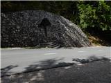
First we drive to Kranjska Gora, then continue our drive towards the Vršič Pass. Just a little before the 3rd hairpin bend of the Russian or Vršič road, we will notice the Ruski križ on the right side, and a smaller parking lot on the left, where we park. Because the parking lot is relatively small and fills up quickly, we can also park a bit higher at the larger parking lot just above the 4th hairpin bend (in this case we have to descend a bit to our starting point at the Ruski križ).
We can also reach the starting point from the Primorska side, namely via the Vršič Pass.
Route description:
A little before the 3rd hairpin bend of the Russian road, we will notice the mountain signs for Koča v Krnici by the road, which direct us slightly left onto a wide cart track that immediately begins to descend moderately. After a few minutes of descent through the forest, the path levels out and brings us to the bed of Suha Pišnica. Shortly after crossing the mentioned stream, the path turns slightly to the left and leads us out of the forest onto the expansive grassy slopes of Planina v Klinu, where we see a solitary hut on the right, and a small memorial park Mali Tamar on the left. The path ahead completely levels out, then joins a forest road that comes from the former Hotel Erika or the bridge over Velika Pišnica. Here we continue right and follow the relatively steep forest road all the way to Koča v Krnici, which we reach after about 20 minutes of further walking.
From the hut we set off left in the direction of Špik (straight on Kriška stena) and for a short time still walk on the flat path through the forest. The path then crosses two smaller torrent beds, at the next wider bed the path turns slightly right and in continuation ascends along the bed for quite some time. Here we mostly ascend through dwarf pine, and from the path we have a nice view especially towards Prisank and Razor. Higher up, the path crosses the bed to the left side and ascends over a steeper slope. When the dwarf pine begins to become somewhat sparser, the marked path turns left, and along the path we will notice a large rock with the inscription „Špik 3h“.
The path ahead ascends transversely across slopes that are still partially overgrown with dwarf pine, higher up from our path a quite inconspicuous PP path (Planica - Pokljuka path) branches off to the left, and we then ascend to the upper part of Tarmanova žlefa, a slope that steeply descends towards Krnica.
Here the path ascends steeply and turns more and more to the right, so that we gradually arrive at the northern slopes of Gamsova špica (1931 m), a bit further we arrive at an indistinct saddle, where the path turns left and after a short ascent brings us to the more demanding part of the path, where with the help of safety equipment we begin to ascend towards Lipnica (on some maps marked as Liprtica). Below the summit of Lipnica the steepness eases and we reach the summit of Lipnica without major difficulties.
From Lipnica we continue along the ridge, the path soon becomes technically demanding. First we descend a little, then with the help of fixed safety aids we traverse steep slopes that connect the Lipnica ridge with Špik.
When we reach or approach a kind of saddle or notch a bit further, the path through Kačji graben joins us from the left (possibility of return to the valley).
We continue straight towards Špik, where there is still the last very steep part in front of us, where we ascend over quite crumbly broken rock on a fairly steep incline, where there is a great danger of falling rocks, the path on this part is not secured.
After 15 minutes the steepness eases and in a few steps we reach the mighty and panoramic summit of Špik.
Starting point - Planina v Klinu 0:20, Planina v Klinu - Koča v Krnici 0:25, Koča v Krnici - branch to Veliko Dnino 0:50, branch to Veliko Dnino - Lipnica 2:40, Lipnica - junction below the summit of Špik 0:20, junction below the summit of Špik - Špik 0:15.

Photos:
 1
1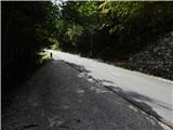 2
2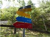 3
3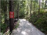 4
4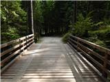 5
5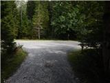 6
6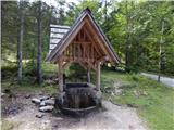 7
7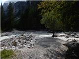 8
8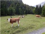 9
9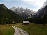 10
10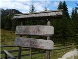 11
11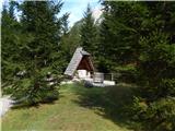 12
12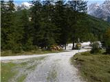 13
13 14
14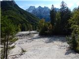 15
15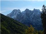 16
16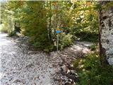 17
17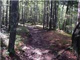 18
18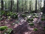 19
19 20
20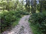 21
21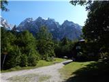 22
22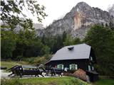 23
23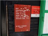 24
24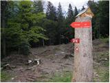 25
25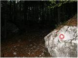 26
26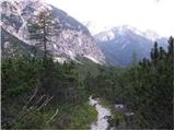 27
27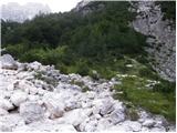 28
28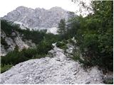 29
29 30
30 31
31 32
32 33
33 34
34 35
35 36
36 37
37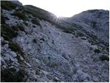 38
38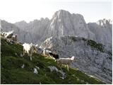 39
39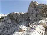 40
40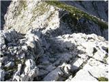 41
41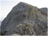 42
42 43
43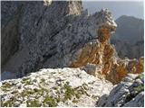 44
44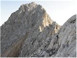 45
45 46
46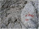 47
47 48
48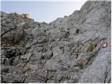 49
49 50
50 51
51
Discussion about the trip Ruski križ - Špik (via Koča v Krnici)
Show older messages
|
| Gost29. 07. 2006 |
if you look at it from below, you think it's practically impossible to get to the top, but once you're up there it's a fairy tale
|
|
|
|
| Gost16. 09. 2006 |
what a fairy tale, up there are the heavens
|
|
|
|
| Gost17. 10. 2006 |
views are beautiful, wouldn't want to go down
|
|
|
|
| majdicst13. 02. 2007 |
I think the full via ferrata set for Špik is just extra unnecessary weight... For those 100 meters of "cable" you really don't need it if you have just a little experience. More important is to have enough water with you. For those 100 meters of "cable" you really don't need it if you have just a little experience. More important is to have enough water with you. The summit is really awesome. The summit is really awesome.
|
|
|
|
| Gost6. 04. 2007 |
Špik is really a fairy tale when you reach the top, and even before there is a magnificent view of the surrounding peaks. Beautiful hike, demanding in terms of fitness, you need to bring enough water.
|
|
|
|
| Gost31. 05. 2007 |
great tour, I agree!!
photos are just like the ones I took myself
only the descent along the snake ridge remained slightly worse in my memory... poor my knees...
|
|
|
|
| Gost31. 05. 2007 |
Precisely because of the knees I think the tour in the opposite direction is less "painful". Tried and tested. Wonderful experience, nice tour.
|
|
|
|
| Gost16. 07. 2007 |
The descent via Kačji greben is great, half the path is scree, the rest you can almost run down entirely. Don't listen to the advice of the previous two guests and go to Špik via Kačji graben, unless you have an affinity for knee-grinding uphill on scree.
The tour is otherwise really great.
|
|
|
|
| Gost8. 08. 2007 |
On Saturday I'm going to Špik for the first time. Is the path more demanding than the one that goes to Prisank from the southern side? Is it more exposed than the one that goes to Prisank from the southern side?
|
|
|
|
| Gost9. 08. 2007 |
Through Grunt it is exposed in some places, through Kačji graben a bit less. The final ascent to the summit is very steep, probably more than that to Prisank. Otherwise I think if you made it to Prisank you'll make it to Špik too.
|
|
|
|
| Gost9. 08. 2007 |
Is it possible to use a self-belay kit on exposed sections (is the path secured there with cables)?
|
|
|
|
| Gost9. 08. 2007 |
Dear soul, these "exposed sections" last a few minutes and a good hundred meters. Just enough to make your skin tingle slightly and feel a breath of the real, remote mountain world.
At least to me, the wire ropes and pegs themselves are enough to drive away grumpy thoughts and feelings. It's different with steep, crumbly scree slopes and unprotected narrow paths.
The path to Špik, as it appears, is pleasant, even though a long mountain tour with an uncomplicated short climbing section. In this case, self-belaying is probably really just extra weight.
Many beautiful mountain experiences and take care,
|
|
|
|
| modri9. 08. 2007 |
The trail is really interesting and beautiful. But something bothered me anyway. That some f.... says it's not worth taking a belay kit for a few 100m of wire ropes is the biggest nonsense. It's always worth taking it, especially if you don't know the terrain. Accidents happen because of such people, and it's always the mountain rescuers who get screwed, who work for free and put themselves in danger because of other f....!

|
|
|
|
| Gost10. 08. 2007 |
Who says it's not worth it and potentially "shouldn't" take it?
Certainly, in case of uncertainty and inexperience, it's useful to always take the kit. I just wanted to encourage the guest a bit: it's not a difficult climbing tour with inaccessible spots. Far more accidents happen to poorly equipped Sunday hikers who, with sports sneakers and a ladies' purse, rely on a harness, some rope and - wire ropes and pegs on the harder spots to help. So no fear of them, our predecessors discovered approaches without pre-made paths and iron.
If I draw a line, Špik is a demanding mountain not for everyone. The well-protected section with wire ropes and pegs is probably one of the safer spots, if you have some experience. But that doesn't mean that self-belaying wouldn't be appropriate for an otherwise mountain lover in case of uncertainty. Still, better to a easier summit first - this path is marked as "very demanding"!
|
|
|
|
| Gost10. 08. 2007 |
Yes, I agree. I'll wait for a better opportunity, or less demanding. Thanks to both for the advice. Can someone suggest a less demanding attractive tour in the Julian Alps?
|
|
|
|
| Gost12. 08. 2007 |
Well, it's not that scary. I was up there when I was 9 years old.
|
|
|
|
| majdicst13. 08. 2007 |
I'm that "some k..." , then I'd like to tell the one who used that "nice, sturdy original Slovenian" word that my remark is my PERSONAL opinion, and if he took it as advice to others, I sincerely apologize to him. Let's leave personal discussions....
I agree with those who say it's better to descend through Kačji graben. The descent drags on endlessly, but it's still much easier to "hold" downhill on scree than to push uphill in the style of "two steps forward and three back". Although at the end in the Koritnica valley I said I'd go up and down via Lipnica next time.... the path isn't longer, but it's nicer to my taste.
|
|
|
|
| Gost13. 08. 2007 |
For those for whom it's too far and too hard, Šmarna gora will be just right. That's why we go, to get a bit dizzy, breathe deeply, sweat. Not the easiest, shortest and almost effortless. Bravo nine-year-old! For courage, without whining and oh at all.
|
|
|
|
| Gost13. 08. 2007 |
Yeah, descent from Špik through Kačji graben to KORITNICA  he must have really dragged himself incredibly ??? he must have really dragged himself incredibly ???
|
|
|
|
| Gost14. 08. 2007 |
Yes, descent from Špik through Kačji graben to KORITNICA
.....ahmmmmm well yeah, I meant Velika Pišnica, anyway...
|
|
|
|
| Gost23. 09. 2007 |
Yesterday my colleague and I were on Špik. We went up from the hut in Krnica, back via Kačji graben. The hike was strenuous, as there was quite some snow in the summit area, which made the otherwise very nice tour a bit more difficult. I must warn that the summit logbook is full and needs to be replaced with a new one. Otherwise everything is super.
|
|
|
|
| Gost5. 10. 2007 |
The more difficult path is through Kačji graben. The section with cables from Krnica is not overly demanding. From Kačji graben, the path is unsuitable for ascent and the lower part is steep in places (rock jumps) and partly secured with pegs. In wet conditions, dangerous for slipping.
|
|
|
|
| m357524. 07. 2008 |
Hello!
I'm interested in the conditions for the above described path to Špik...
Thanks for the answers and best regards.
|
|
|
|
| ben24. 07. 2008 |
Conditions on the described path are good, no snow, safety gear in excellent condition, so just hit the trail and good luck.
|
|
|
|
| andrej mateja4. 08. 2008 |
Choosing between Špik and Škrlatica. Which tour to choose? Thanks for the help.
|
|
|
|
| ben4. 08. 2008 |
Both are nice, but nevertheless from this serpentine to Škrlatica it is quite long, especially if you also have to return via Kriška stena. Therefore it's better to take Špik from here, and Škrlatica maybe from Vrata, or via Pogačnikov dom.
Good luck.
|
|
|
|
| cat enchanter8. 07. 2009 |
Is the trail already dry? Planning a trip on Sunday?
Regards
|
|
|
|
| andrej mateja24. 07. 2009 |
A little less than a year has passed until we finally reached Špik. The weather was ideal today. It is indeed a more demanding tour at least in terms of fitness. We parked by the main road before the bridge, went to the hut in Krnica and then to Špik, on the way back we returned via Kačji greben. On the descent from the summit we met two hikers who had come up in the opposite direction and were completely exhausted. I agree with them as we got properly worn out on the descent - knees hurt. Otherwise the tour was very pleasant, the view is phenomenal.
|
|
|
|
| barjus31. 07. 2009 |
Here, we did the tour today. We were at the top in three and a half hours and met one person on the entire trail. The intermediate peaks pull your leg a bit, because the summit really isn't visible almost until the end. There are very few fixed ropes, just enough to make you crave them Well, the snake ridge is its own path. At the beginning you scramble a bit on loose stones, then you run on the scree, then it's a tedious path to the valley that really drags on.
|
|
|
|
| Parkeljc9. 09. 2009 |
Yesterday summited from the Krnica hut via Liprtnica. Weather excellent but windy. Recommended gloves and hat, windstopper and warm layer underneath. Drank 2 liters of fluids. View wonderful. In August hiked all noteworthy peaks in Karavanke, respected Špik due to fixed protections. Compared to Triglav ascent Špik is a breeze! Last 100m elevation on shady side snow bothers a bit but nothing serious. Descent via Kačji graben - phenomenal. Descended at least 300m elevation on scree in half hour. Met foreigners "dying" ascending Kačji graben. Scree path snowy - unusable. As someone above wrote "two steps up, three down". Path excellently marked both ways. Even if paid, wouldn't go reverse!! Real slip risk on shady parts of Kačji graben even afternoon. Last storm caused real havoc in gullies, especially valley. Both roads washed away, restoration takes years (elsewhere faster). Regret not summiting Špik earlier!!
|
|
|
|
| ves198210. 09. 2009 |
I was also on Špik on 8.9.2009. Parkeljc, I think we met just below the summit (you down, us up). I agree with everything you wrote. The ascent to Špik is much nicer via Lipnica (beautiful views of the neighboring mountains, and the trail gradually steepens). The descent through Kačji Graben was harder than expected; in wet weather it can be quite unpleasant. I also advise against the ascent via Kačji Graben (very strenuous trail, no views; after all the rocky jumps, there's even more strenuous scree waiting).
Very nice hike!
|
|
|
|
| Parkeljc12. 09. 2009 |
Hello "ves1982"!
Yes, you were probably the one in the light brown pants with two others. Not bad! Somewhere in the middle we met some foreigners who looked really pitiful (you were probably already at the summit then). At the summit, you need to look around a bit, as upon closer inspection there are two stone shelters, and if you find them, it can be quite pleasant at the top. Otherwise, the only danger is meeting just below the summit, as if you're not careful, you might accidentally roll a stone down, which could hit an unprepared hiker.
|
|
|
|
| ves198212. 09. 2009 |
Yes, exactly, that was me  . We also met that group on the way down, right at the top of the scree they were resting and slowly puffing towards the summit. It was already hot then! End of July this path is killer ... . We also met that group on the way down, right at the top of the scree they were resting and slowly puffing towards the summit. It was already hot then! End of July this path is killer ...
Best regards until the next meeting! And many nice hikes
|
|
|
|
| breza25. 09. 2009 |
If you are the three hikers from Logatec or someone else who later saw my hiking poles that I forgot next to the car and they were then by the roadside, please contact me at tel. no. 040 418035! Oliver
|
|
|
|
| solja26. 09. 2009 |
Could someone please explain where to go to Špik 'via Grunt'. We've always gone up via Lipnica and (usually) descended through Kači graben. Is this perhaps a new path?
Best hiking regards and happy trails
|
|
|
|
| viharnik26. 09. 2009 |
Via Grunt or more correctly Gruntovnica is a rocky mountain valley through which a seasonal stream flows. We cross it from the hut in Krnica, later the path turns to the left scree slopes under Gamsova špica 1931m. Up there there used to be only a wooden cross wrapped in copper wire. Now they've stupidly renamed it Lipna špica.
|
|
|
|
| ramses27. 05. 2010 |
I've already been to Špik about 10 years ago when I was 12 via Kači greben... now I'd like to go again, but I'm wondering when it's safe to go without snow. I plan to set off around mid-June, wondering if by then it's possible to go up without crampons and ice axe?
|
|
|
|
| smidov david23. 06. 2011 |
Hi, I plan to go to Špik from Krnica on Saturday. I'm interested in the snow conditions on the path, can the snow be bypassed or is winter gear needed?
Any information would be welcome.
|
|
|
|
| lukecpukec27. 06. 2011 |
Yesterday I was on Špik...path from Krnica is completely dry...while on the path over Kači graben you need to cross one small snow patch. LP
|
|
|
|
| planika14. 10. 2011 |
It bothers me when some people (at all mountains..) proudly write something like this - it says 4 hours, we only took 3h. Why do that, since there's a difference if 1 person goes, 2 or even 15 people, who absolutely and logically take even more than stated??
Are they self-praises that elevate you??
|
|
|
|
| pirseb2429. 07. 2012 |
Hello
I'm interested in the following. I started hiking in the mountains recently, condition-wise I probably wouldn't have problems with the ascent but I have issues with height (fear, vertigo) that I'd like to overcome. I'm wondering if this tour is suitable for me or what you recommend, which mountain is the most suitable for beginners in climbing.
Thanks for your opinions and answers
|
|
|
|
| jax29. 07. 2012 |
This path is nothing special. Actually, you have a little ridge where things open up a bit - nothing special, and on it one spot where you have to go a bit steeper up along a fixed rope. The photos are okay (though my experience is that on photos difficult spots usually look much worse than they actually are), then a bit more up easy rocks to the top. Now - I don't know what it means that you have issues with height. If you really can't stand any view into the depth at all, then of course not. But if it's just some mild discomfort, then you shouldn't have any problems up there.
As for easy paths in the high mountains - such a classic is probably Grintovec, but I don't recommend it to anyone because it's mainly a recipe for you to hate the mountains for life - tedious, endlessly long, constantly steep, hot, stuffy. Maybe a nice suggestion is Kalški greben from Krvavec - the variant via Zvoh has one exposed spot, while via planina Koren or Dolga njiva the path is completely easy - and in fact a very nice and varied trip.
|
|
|
|
| pirseb2429. 07. 2012 |
Thanks for the reply. I was just yesterday on Mangart Italian route and I had no problems at all, but I don't know what the comparison is between Mangart and this mountain
|
|
|
|
| krpan7. 08. 2012 |
Informative - to Špik via Grunt in the morning hours, expected arrival at summit around noon - in case of sunny weather you are exposed to the sun all the time but there are also some shady spots.
|
|
|
|
| el rocco19. 08. 2012 |
Yesterday, my wife and I summited Špik. We left the car at the 3rd hairpin turn on Vršiška cesta (at the cross), and headed towards the Koča v Krnici hut and then to the summit. It took us an hour longer to the top (5.5h) than stated, because from the saddle onwards I had cramps that prevented normal walking. This surprised me a bit as I haven't had such issues for a long time, but the 1600m elevation gain is no small feat. Špik requires fitness, and those without it should avoid it. Anyway, despite the troubles, once you reach the top, everything is rewarded You find yourself in great company, and what company... Mojstrovka, Mangart, Jalovec, Prisojnik, Razor, Škrlatica like in a theater, Špik as the conductor. So close, I don't know if you can see them from anywhere else like that. F E N O M E N A L, one of the best views in the Julian Alps for me. Since every good thing ends too quickly, the descent followed, which in the second half was pure suffering due to the heat mercilessly scorching the hikers. There is some shade among the pines, but since they retain heat they act like radiators and it feels 10 degrees hotter there. Salvation comes when you reach the shade of the trees just before the hut and order a cold Radler,... later you also cool your feet in the Pišnica. Anyway, the trip was a bit strenuous but worth every drop of sweat. As for exposed sections and climbing, compared to the neighboring peaks, it's no big deal.
|
|
|
|
| uroscec20. 08. 2012 |
I join El rocca's opinion. On Saturday it was hellishly hot on the return. The sun scorches you the whole way back, shade is very little. Among the pines and on the scree, all the way to the hut in Krnica I felt like slowly cooking in a gypsy pot But that's why the cold beer tasted even better, not to mention soaking feet in Pišnica
Nice trip!
|
|
|
|
| Janiel7420. 08. 2012 |
But I was yesterday (Sunday) on Špik. Circular tour. Up via Grunt, down Kači Graben.
Because of Saturday's Ankogl I was late, had to park somewhere on the 2.5th serpentine Path not demanding, but quite long. 15m seriously exposed. Views really unique. As el rocco mentioned. You have everything in view. At the top I treated myself to a longer break, as I was alone and lying watched Škrlatica summit. Really Špik has unique location. Down first very fast, enjoyable run... met a couple who crawled up that steep scree (my condolences..), towards the end it dragged. Heat too Anyway Špik will probably come up again sometime
|
|
|
|
| zvone127. 08. 2012 |
Does anyone know if there is now a stamp at the top of Špik?
|
|
|
|
| el rocco27. 08. 2012 |
Yes, the stamp is at the top on the same rock as the logbook box, just on the other side.
|
|
|
|
| zvone128. 08. 2012 |
El rocco, thanks for the reply.
LP!
|
|
|
|
| luigi15. 09. 2012 |
If by chance someone is reading comments about Špik, let the blonde lady in green who was with her friend on Špik on August 25th get in touch.
|
|
|
|
| siggi2. 08. 2013 |
Hello. Tomorrow I'd like to do a loop tour - over Grunt to the summit and descent via Kačji Graben. I'm interested if the paths cross somewhere or how to get back to the same starting point (as far as I read, the starting points are different for both paths). thanks
|
|
|
|
| _sandra_2. 08. 2013 |
same starting point via Lipnica and via Grunt..
|
|
|
|
| Daaam2. 08. 2013 |
put it on the map
|
|
|
|
| skočnik122. 08. 2013 |
Is the path through Kačji graben and over Lipnica snow-free?
|
|
|
|
| katja879. 10. 2013 |
On Thursday, 3.10.2013, at the top of Špik (up past Koča v Krnici and down via Kači graben).
The path via Lipnica is very nice and varied. Through Kači graben the problem was that it was quite frozen and therefore dangerous, the lower part quite muddy. Next time we'll surely go back the same way
When we got above the clouds (around 2000m), the views were fantastic. There were some patches of snow at the top. At the end of the path in Krnica we also came across a large boletus
Photos from the hike can be viewed on the website of Planinsko društvo Matica Murska Sobota: http://www.mojalbum.com/pdmaticams/20131003-spik-cez-lipnico/ruski-kriz/21166761
|
|
|
|
| jesiha2221. 08. 2014 |
Has anyone been recently on the path via Lipnica to Špik / how much snow is left and where?
|
|
|
|
| petruš2. 10. 2014 |
Hi... what are the snow conditions like on Špik? What do we know ?
|
|
|
|
| Domch2. 10. 2014 |
on Saturday it was bare and dry. Wet rock from dew was only in the lower part of the descent via Kačji graben.
|
|
|
|
| markohorvat26. 10. 2014 |
I'm interested in the conditions on this trail. Is it possible without winter gear? Thanks.
|
|
|
|
| Pandora12. 07. 2015 |
Hello!
We were there yesterday, a group of four. We overnighted at Koča v Krnici. Fantastic tour, wonderful people who care for and live with the hut and mountains.
|
|
|
|
| malimiha4. 11. 2015 |
We plan to go to Špik this weekend. I would ask for info on both paths, are they dry? Thanks and best regards
|
|
|
|
| loki15. 11. 2015 |
Today I did exactly this tour. I carried all my winter gear, but didn't use it as there was no need. No snow up to the ridge between Špik and Lipanca. On the ridge there's very little, easy to avoid. Some patches on the scree in Kači graben, but no crampons needed, can avoid it. Trouble at the end of the scree in Kači greben towards the valley, as it's wet all day in places and very slippery. Watch for wet rocks. I slipped hard a couple of times Further on where deciduous trees grow, leaves cover rocks and roots, same story as before. For info: return took almost as long as ascent.
Best regards and good luck
|
|
|
|
| malimiha6. 11. 2015 |
AHA ok thanks for the info. Plan to go up through Kači graben and then to Krnica. Regards
|
|
|
|
| lito13. 07. 2016 |
Hello,
on Saturday I plan to ascend this route and descend via Kači graben.
Does anyone have any information about snow on the path?
Thanks!
|
|
|
|
| nteam13. 07. 2016 |
On Sunday (10.7) I went in the opposite direction.
There were still a few snow patches at the top of the scree, but you can go around them).
Good luck!
|
|
|
|
| Mihc0079. 12. 2016 |
Yesterday (8.12.2016) I walked the path described above, descended via Kači greben. Conditions were good and the weather changeable.
Report:
https://mihagre.blogspot.si/
|
|
|
|
| Marko Torelli12. 08. 2019 |
Hello, on 11.8.2019 we did the ascent. Trail without peculiarities, markings excellent, protections at the key point impeccable. Descent through Kači graben absolutely does not count as a leisurely mountain descent. You just have to descend 1500m, the steepness doesn't let up for a moment, so when climbing to the top save your strength... you'll need it. p.s. no goats in this ravine at all.
|
|
|
|
| J.P.1. 09. 2019 |
The path past the hut is a great choice towards the summit. We steadily gain elevation meters because the path is well laid out. Below the summit a bit of scrambling and then enjoy the top. For the return, use the potential of Kači greben and "ski" half the path. I advise against Kači greben for ascent. Really not sensible. Lp
|
|
|
|
| Kanjanez27. 08. 2020 |
We did a circular tour; up past Krnica, down through Kači graben. Although the latter is quite steep, it's fine because you have shade for the descent, and scree at the beginning
The ascent path is flawless, we lost the markings a bit and then went our own way over scree and rode the bushes, but still arrived on predicted time. So the time is not "stretched" but normal, most can make it.
Self-belay kit? Hm, only one part is vertical, elsewhere more climbing fun.
The views compensate for any mental struggle some might have on the ascent - there are many peaks that are not yet the top
|
|
|
|
| MPS27. 10. 2020 |
Short video from the hike to Špik.
Ascent past the hut in Krnica and descent through Kačji graben. Video on the link: Špik 2472 m, 13.9.2020
Hope it helps someone get an idea of the path itself. Safe steps, Mirko.
|
|
|
|
| Majdag27. 10. 2020 |
Nice girl, what you're carrying..
|
|
|
|
| potka12347. 07. 2021 10:37:40 |
hi! can someone please tell me if the path to špik via koča v krnici is completely dry? is winter gear still needed?
|
|
|
|
| TilenP5. 08. 2021 10:57:01 |
The path is completely dry. The same for the path through Kačji greben.
|
|
|
|
| Lenore24. 09. 2021 18:23:45 |
Why is the path marked as VERY DIFFICULT?
|
|
|
|
| Lenore3. 10. 2021 20:37:43 |
I went up via Krnica, down via Kačji graben.. and if I had to choose again, I'd go down via the Krnica hut too (even though it wouldn't be circular).
Kačji graben is great for descent as long as there's scree.. but when the scree ends.. it's horribly steep through the forest, rocks slide, roots slide, long and unpleasant path for descent there.
But I can't imagine going up there (because of the scree).
|
|
|
|
| dvojnit5. 08. 2022 21:30:25 |
Based on the comments, someone else might think that the described path past Koča v Krnici is a stroll, while the one through Kačji graben is suffering .
Today I did a circular route up past Koča v Krnici and down through Kačji dol. Perhaps it was the dog-day heat, but it dragged on the ascent. This path is also quite steep in certain sections. Still, it's 1600 m of elevation gain. Just before the summit, the view of the ridge from Lipnica to Špik can be quite dramatic for some. Still, I recommend this route for the ascent to everyone, as it's really very scenic. But you need to have fitness, because 1,600 m of ascent is no joke.
Nevertheless, for the descent I would recommend Kačji greben. I didn't feel like going back the long way around. For a feel: you cover 600 vertical meters of scree in 20 minutes. Then in the forest afterwards it's not so bad, at least if it's dry it's quite pleasant. In wet conditions, the leaves could really slip. Anyway, via Kačji you complete the entire descent in about 1:45 and then just a walk to the starting point (Ruski križ or bridge over Pišnica). I think that more than makes up for it. For ascent via Kačji though... I don't know, very steep, completely viewless, and it's questionable how much faster you actually are if you're grinding your knees up that slope... The lower part of the scree is already secured, the upper 400 m is not, which means 2 steps up, 1 down.
The downside of the circular route in this direction is only that you might not feel like walking back to Koča v Krnici on an empty stomach . On the other hand, if your starting point is Ruski križ and the Pišnica hut is dry, you cross nicely, past the isolated hut - a sharp eye will spot the fenced grave at the edge of the forest. The stone says that Kekčev volkec rests there. In the torrent gully by the hut, someone recently made a boardwalk like in Blejski Vintgar. A couple of minutes further on is apparently also Bedančeva hiša - open-air museum. In front of it, there's even a dug pit/trap for catching bears in the ground. But it's fenced and secured with a net. In short, on this return path you have something to see too.
|
|
|
|
| djimuzl6. 08. 2022 01:33:38 |
There is a pear on this path
|
|
|
|
| goretz7. 08. 2022 23:23:27 |
We took this path with a colleague to Špik on 5.8.2022, and returned via Kačji graben. Priceless views, and at the same time we walked more than half of the ascent in the shade. There's a more exposed section in between, which is secured with a cable (picture 40). You only see the summit in the last few hundred meters, and at first glance at Špica it wasn't clear to us where the path was supposed to lead. When crossing the scree slope, a few meters of cable helped us, then a nice path opens to the top, but caution is still advised..
Kačji graben is another story - the descent over the scree didn't seem too tiring to us, but it gets worse lower down when the legs are already tired, and the path doesn't spare us on the way down, as at every bend you wonder how you'll "clamber" over the next few pegs and rocks, and poles are practically useless in these sections. When we finally stepped onto the walking path in the valley, we were the happiest, but overall I can't imagine ascent or descent via Kačji graben..
I would also advise taking more than enough water with you, as walking on the long scree turned my clothes into salt mines
Good luck 
|
|
|
|
| jax8. 08. 2022 11:14:03 |
You can imagine the descent via Kačji graben since you just did it. It's exactly like that - steep, unpleasant, unrelenting, nothing but cursing. Whether it's still worth it, let each decide for themselves.
|
|
|
|
| dprapr8. 08. 2022 14:31:37 |
Jax, you're exaggerating a bit with that cursing, just like I exaggerate with comments on your comments.
Everyone decides for themselves which paths to take up and down. I don't know why someone would go somewhere unpleasant where they have to curse.
The fact is that Špik is beautiful from the Martuljek side, from this side both marked paths aren't the most interesting. Even less in summer. There are many nicer paths, but once you have to go up there too.
With sufficient physical fitness, this ascent and descent aren't anything special.
|
|
|
|
| goretz8. 08. 2022 19:46:12 |
@jax it was meant in the sense that I can't imagine ascending the Kačji graben and then descending through it too... The path isn't scenic either, so you don't miss anything returning via the path past the Koča v Krnici.. Personal opinion
|
|
|
|
| ugi39. 08. 2022 22:35:24 |
For the ascent I much prefer the path through Kačji graben, just set off early enough to avoid the heat. Otherwise I avoided it for a long time because I read it was unpleasant, but really nothing special. The path through the scree is also routed so that there is no problem.
For descent however preferably past the hut, the path drags a bit but is easier on the feet.
|
|
|
|
| Alex198215. 08. 2022 06:09:37 |
100 people 100 wonders..no one can tell me that the path along Kačji greben is nothing special..especially uphill..I went downhill..and it was tough for me..ok over the scree it was still ok..from the forest onwards it was really tough..in short, for Špik you have to be in good condition...good luck
|
|
|
|
| Po Hodnik31. 10. 2022 17:48:00 |
I join the opinion that Kačji Graben is better for descent, as over the scree in 30-45 minutes you can descend 700 elevation meters, but still attention is needed later in the forest, where we constantly descend and knees suffer.
But technically the path is quite easy, except for one fixed cable 15 minutes before the summit and the final ascent, still stamina-demanding. Wonderful views of the neighboring mountains of course make the path easier
|
|
|
|
| Norge20. 07. 2025 11:34:13 |
Yesterday my colleague and I hiked this trail for the first time. Mostly very scenic, technically undemanding, same for the via ferrata section, but still quite fitness-demanding, especially compared to Grintovec via Streha. On display: Kukova špica, Škrlatica, Razor, Dolkova špica, Vršič, Mojstrovke, also Jalovec and Mangart, large part of Austria and part of Italy visible. Recommend early start due to direct sun on return, especially through Kačji graben, which next time I'd avoid in a wide arc
|
|
|
|
| Tajka675. 09. 2025 10:03:22 |
Yesterday I also did this devilish Špik. Very strenuous for me, I took one hour more than the prescribed time for the ascent. At the top of Lipnica I couldn't find the markers for a while, the entire upper part is poorly marked. The views though.... every drop of sweat rewarded. Down through Kačji graben, mistake.
|
|
|
|
| bbugari15. 09. 2025 18:09:26 |
"Down through Kačji graben, mistake."
|
|
|
|
| Vrhovka21. 09. 2025 09:16:48 |
Yesterday's ascent to Špik, the path is well marked, but some markings have really faded, especially higher up, and you need to look more carefully. However, the path is easy to follow, so no fear. Descent via Kačji graben, I think it's also better than going back the same way.. it really saves a lot of time. Mountain worth visiting! The views reward all the effort
|
|
|
To post a comment you must log in:
If you do not yet have a username, you must first
register.