Ruski križ - Lipnica (via Koča v Krnici)
Starting point: Ruski križ (1036 m)
| Latitude/Longitude: | 46,4444°N 13,7746°E |
| |
Route name: via Koča v Krnici
Walking time: 4 h 15 min
Difficulty: difficult marked way
Elevation gain: 1382 m
Elevation difference along the route: 1445 m
Map: TNP 1 : 50.000
Recommended equipment (summer): helmet
Recommended equipment (winter): helmet, ice axe, crampons
Views: 21
 | 1 person like this post |
Access to starting point:
First we drive to Kranjska Gora, then continue driving towards the Vršič Pass. Just a little before the 3rd serpentine of the Ruska or vršiška road, we will notice the Russian Cross on the right side, and on the left a smaller parking lot, where we park. Since the parking lot is relatively small and fills up quickly, we can also park a little higher up in the larger parking lot just above the 4th serpentine (in this case we have to descend a little to our starting point at the Russian Cross).
We can also reach the starting point from the coastal side, namely via the Vršič Pass.
Route description:
Just a little before the 3rd serpentine of the Ruska road, we will notice the mountain signs for Koča v Krnici along the road, which direct us slightly to the left onto a wide cart track, which immediately starts to descend moderately. After a few minutes of descent through the forest, the path flattens and leads us to the bed of Suha Pišnica. Just a little after crossing the mentioned stream, the path turns slightly to the left and leads us out of the forest onto the vast grassy slopes of Planina v Klinu, where we notice a solitary hut on the right and a smaller memorial park Mali Tamar on the left. The path ahead completely flattens, then it joins the forest road that comes from the former hotel Erika or the bridge over Velika Pišnica. Here we continue right and follow the relatively steep forest road all the way to Koča v Krnici, which we reach after about 20 minutes of further walking.
From the hut we set off left in the direction of Špik (straight Kriška stena) and for a short time we still walk on the flat path through the forest. The path then crosses two smaller torrent beds, at the next wider torrent bed the path turns slightly to the right and in the continuation climbs along the gully for quite some time. Here we mostly climb through dwarf pine, from the path we have a nice view especially towards Prisank and Razor. Higher up the path crosses the gully to the left side and climbs up a steeper slope. When the dwarf pine starts to become somewhat sparser, the marked path turns to the left, and along the path we will notice a large rock with the inscription „Špik 3h“.
The path ahead climbs transversely across the slopes, which are still partly overgrown with dwarf pine, higher up from our path the PP path (Planica - Pokljuka path) branches off quite unnoticeably to the left, we then climb to the upper part of Tarmanova žlefa, a slope that steeply descends towards Krnica.
Here the path climbs steeply and turns more and more to the right, so that we gradually arrive on the northern slopes of Gamsova špica (1931 m), a little further on we arrive at an indistinct saddle, where the path turns to the left and after a short climb brings us to the more demanding part of the path, where with the help of fixed protection we begin to climb towards Lipnica (on some maps marked as Liprtica). Below the summit of Lipnica the steepness eases and we reach the summit of Lipnica without major difficulties.
Starting point - Planina v Klinu 0:20, Planina v Klinu - Koča v Krnici 0:25, Koča v Krnici - branch to Velika Dnina 0:50, branch to Velika Dnina - Lipnica 2:40.

Along the route: Mali Tamar (996m), Planina v Klinu (980m),
Koča v Krnici (1113m), Odcep v Veliko Dnino (1425m)
Photos:
 1
1 2
2 3
3 4
4 5
5 6
6 7
7 8
8 9
9 10
10 11
11 12
12 13
13 14
14 15
15 16
16 17
17 18
18 19
19 20
20 21
21 22
22 23
23 24
24 25
25 26
26 27
27 28
28 29
29 30
30 31
31 32
32 33
33 34
34 35
35 36
36 37
37 38
38 39
39 40
40 41
41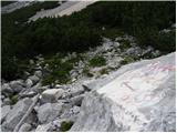 42
42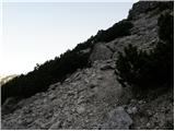 43
43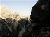 44
44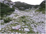 45
45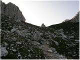 46
46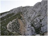 47
47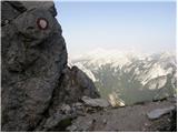 48
48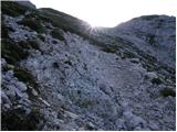 49
49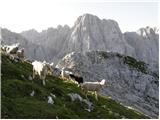 50
50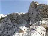 51
51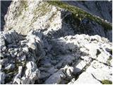 52
52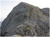 53
53 54
54
Discussion about the trip Ruski križ - Lipnica (via Koča v Krnici)
To post a comment you must log in:
If you do not yet have a username, you must first
register.