Starting point: Rudno polje (1347 m)
| Latitude/Longitude: | 46,3458°N 13,9236°E |
| |
Walking time: 4 h 25 min
Difficulty: difficult marked way, difficult pathless terrain
Elevation gain: 740 m
Elevation difference along the route: 1000 m
Map: Triglav 1:25.000
Recommended equipment (summer): helmet
Recommended equipment (winter): helmet, ice axe, crampons
Views: 16.850
 | 2 people like this post |
Access to starting point:
From highway Ljubljana - Jesenice we go to the exit Lesce and follow the road ahead towards Bled. In Bled at the traffic lights, the signs for Pokljuka point us to the right. Ahead we drive through Gorje and past the abandoned ski slope Zatrnik to Rudno polje on Pokljuka (large parking lot, barracks and shooting range).
Route description:
At the end of the parking lot a macadam road branches off to the right, alongside which there are signposts for Triglav. We head onto the mentioned road, which slightly ascends and after ten minutes of walking brings us to the Viševnik ski slope. We continue on the road, from which soon to the left branches off a marked path towards Triglav.
We continue in the direction of Triglav and after a few minutes of moderate ascent we arrive at a forest road, which we follow for only a few meters (until here it used to be possible also by car). The marked path then turns right and for a short time ascends more steeply, after ten minutes the steepness eases and the path slowly transitions onto steep slopes. Across the steep slopes the path mostly gently descends and increasingly turns to the right. A little further, we will notice to the left below us the mountain pasture Konjščica. Our path then stops descending and transitions from the forest into the bushes. The path, which ascends again, leads us below steep cliffs and soon brings us to a junction, where we join the path from mountain pasture Konjščica.
From here follows a shorter ascent and the path brings us into a nice little valley named Jezerce, where it branches. Here there are also signposts directing us left (right Srenjski preval, Viševnik Blejska koča na Lipanci...), while our initially gentle path takes us to the spring below Studorski preval. After the spring the path gradually becomes steeper, from the left side of the torrent higher it transitions to the right side, where we enter a grassy slope, the path by which we ascend still being rocky. Follows an ascent in a few serpentines and we ascend to Studorski preval, from which a nice view opens onto the mountains above Bohinj.
Here from the right joins a demanding path from Srenjski preval, from our path also branch off unmarked tracks to Ablanco and Veliki Draški vrh.
From the saddle we first for a short time descend more steeply, then the path turns into the right direction, we then for a longer time with some shorter easy ascents and descents traverse slopes towards the left. From the slopes of Veliki Draški vrh we gradually arrive onto the slopes of massive Tosc, we with nice views continue past the branch of the path to Tosc and the junction, where from the left also joins the path from Uskovnica.
At all junctions, also at that where partly abandoned path leading over planina Zgornji Tosc joins us, we continue straight, the path gradually brings us onto steeper and also precipitous southwest slopes of mountain Tosc, where there was a landslide some years ago, so some additional caution is needed due to falling stones. Across the precipitous part leads a quite wide path, so no special problems on this part, when the slope becomes less steep then from the left also joins the path from Stara Fužina or Voje valley.
We continue straight on the wider marked path towards Triglav, which continues towards the north, leads us along western slopes of Tosc, still gentle path across some scree fields brings us to Vodnikov dom on Velem polju, where is the next junction.
Also here we continue straight in the direction of Triglav, the path starts to ascend transversely across slopes of Vernar, higher it also becomes technically demanding. Follows some traversing, where chain assists us, higher we arrive at a steep jump, where with help of numerous pegs and chain we ascend on rocky steps.
The path ahead flattens, the slope becomes less steep and near Konjsko sedlo also somewhat more grassy.
To Konjsko sedlo we easily descend, from marked junction on the saddle we direct ourselves right onto a less visible track, which from the marked path directs right, towards southeast. A little further we quickly reach grassy slope, where the track finally disappears. Across the grassy part we continue upwards, when the band of bushes on the left ends we direct left towards the ridge. We quickly reach the ridge, along it we continue to the summit rocky part of Oklo. Follows some easier climbing across rugged rocks, such "path", which in the last part is also somewhat exposed, we follow to the top of Oklo, where stands a cairn.
Orientation from Konjsko sedlo to the top of Oklo is somewhat more demanding, especially in fog.
Rudno polje - Studorski preval 2:20, Studorski preval - Vodnikov dom 1:00, Vodnikov dom - Konjsko sedlo 0:45, Konjsko sedlo - Oklo 0:20.

Photos:
 1
1 2
2 3
3 4
4 5
5 6
6 7
7 8
8 9
9 10
10 11
11 12
12 13
13 14
14 15
15 16
16 17
17 18
18 19
19 20
20 21
21 22
22 23
23 24
24 25
25 26
26 27
27 28
28 29
29 30
30 31
31 32
32 33
33 34
34 35
35 36
36 37
37 38
38 39
39 40
40 41
41 42
42 43
43 44
44 45
45 46
46 47
47 48
48 49
49 50
50 51
51 52
52 53
53 54
54 55
55 56
56 57
57 58
58 59
59 60
60 61
61 62
62 63
63 64
64 65
65 66
66 67
67 68
68 69
69 70
70 71
71 72
72 73
73 74
74 75
75 76
76 77
77 78
78 79
79 80
80 81
81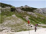 82
82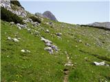 83
83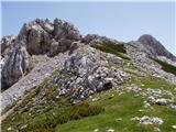 84
84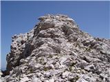 85
85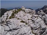 86
86
Discussion about the trip Rudno polje - Oklo
|
| ločanka18. 07. 2014 |
I'm not entirely sure that this peak is Cesar. If I read the article by Janez Pikon with the above title, Cesar is the hill standing opposite to it. It is much more imperial in shape and with an even better view. It is visible as a prominent hill from Malega polja and stands to our right side all the way to Konjkega sedla. Who knows the correct answer?
|
|
|
|
| kolosej21. 08. 2018 |
The description and pictures are correct. The confusion arose because the coordinates for Oklo (2092m) and Cesarja (2098m) on the Triglav 1:25000 map, where in the request for better data they do not rule out the possibility of errors, are swapped.
Please clarify if it is necessary to step onto the large rock in the crack right below the top of Kurica?
|
|
|
|
| damijanp8. 10. 2018 |
On Friday's wonderful day, my wife and I used it to visit the peaks around Cesar. I agree with @ločanka that, based on all available descriptions, Cesar is the peak opposite the described one. Actually, it doesn't matter, they are all beautiful.
Due to the confusion with names, my wife and I also visited Veliki Draški vrh on the way back, so we could at least be sure of the name for one visited peak  
Some photos are at:
Peaks around Cesar - Veliki Draški vrh
|
|
|
|
| Majdag8. 10. 2018 |
lijaneja
17.9.2018 - Cesar is on the right and covers Vodnikov dom.... It was written by lijaneja, so the same one that ločanka writes about.
|
|
|
|
| damijanp8. 10. 2018 |
@Majdag: Thanks. That's how it seems to me too, or rather, that's how it's most often listed online.
|
|
|
|
| Darxta4. 10. 2023 13:14:03 |
At the starting point, it is slightly incorrectly written that it is 1h 30min to Studorski preval. And at Studorski preval, that it is again 1h 30min to Vodnikov dom.
A better guide is Rudno polje - Studorski preval 2h, Studorski preval - Vodnikov dom 1h 20min.
|
|
|
|
| Tadej29. 12. 2025 16:37:45 |
Thanks for the notice. I have corrected the description to say it's Oklo.
|
|
|
To post a comment you must log in:
If you do not yet have a username, you must first
register.