Rudnik v Topli - Dom na Peci
Starting point: Rudnik v Topli (1080 m)
| Latitude/Longitude: | 46,4859°N 14,7647°E |
| |
Walking time: 2 h
Difficulty: easy marked way
Elevation gain: 585 m
Elevation difference along the route: 650 m
Map: Kamniške in Savinjske Alpe 1:50.000
Recommended equipment (summer):
Recommended equipment (winter): ice axe, crampons
Views: 21.118
 | 3 people like this post |
Access to starting point:
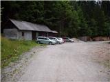
A) We drive to Črna na Koroškem (to here from Ravne na Koroškem or from Šoštanj through the Spodnje Sleme pass), and then we continue driving towards Koprivna. Further on, we ascend along the Meža River, and we drive alongside it to the crossroads, where the road into the Topla Valley branches off to the right. The path ahead leads us along the Topla stream, and we drive on the ascending road to the parking lot by the entrance to the mine in Topla.
B) We drive to Luče (to here from Mozirje or from Kamnik over the Volovljek pass (Kranjski Rak)), and then we continue driving towards Logarska dolina. In the village Solčava we leave the main road towards Logarska dolina and continue driving right in the direction of Podolševa, Spodnje Sleme pass and Črna na Koroškem. Further the road loses its asphalt surface, and after a few kilometers at the crossroads in Podolševa we turn right towards Črna na Koroškem. The road, which further mostly ascends transversely, brings us after some time to the Spodnje Sleme pass. From the pass the road starts descending, and we follow it in the direction of Črna na Koroškem. When after a few kilometers we descend into the valley, at the crossroads we turn right towards Črna na Koroškem (left Koprivna). We descend along the main road only briefly, and then the signs for Topla Valley direct us left onto the ascending road. The path ahead leads us along the Topla stream, and we drive on the ascending road to the parking lot by the entrance to the mine in Topla.
Route description:
At the end of the parking lot, we arrive at a junction of two rougher macadam roads, where we turn sharply left in the direction of the mountain hut Dom na Peci. Further the road crosses a clearing above the parking lot and only a little higher brings us to the next junction, where we continue right (left entrance to the mine - 5 minutes). The path ahead leads us on the road which gradually changes into a cart track, and it brings us a little further to the next marked junction.
We continue on the lower wider cart track (slightly left Knipsovo sedlo), which further crosses a pasture fence and behind it brings us to a trough with water. The path ahead crosses a partly panoramic meadow, behind which it enters the forest and starts to ascend more steeply. Higher, the path leads us across a gully, behind it it starts ascending through the grass-covered forest. A little higher we arrive at the spot, where a sign »novo trasirana pot« directs us left into the steep slope (old path is closed because of a landslide which prevents safe passage). For a short time we ascend steeply, and then the path brings us to the aforementioned landslide, which we reach higher than the old path. Also on the new path route the passage is somewhat awkward and dangerous for slipping. On the other side of the landslide slope the path again starts to ascend steeply and further returns to the renovated old path. The path ahead in moderate ascent crosses the slopes towards the east, and we walk along it to the junction at the hunting hut (we notice the hunting hut on the right side, and it is somewhat off the path).
From the junction we continue in the direction of the mountain hut Dom na Peci, and the path after a few minutes brings us to the next junction.
Here we continue directly to the mountain hut Dom na Peci, to which we have only a few minutes of walking left, or we can continue right to the King Matjaž Cave, to which we have approximately 5 minutes of walking. If we continue past the cave the path is approximately 10 minutes longer.

Photos:
 1
1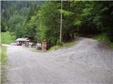 2
2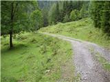 3
3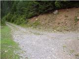 4
4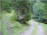 5
5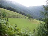 6
6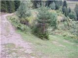 7
7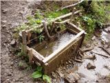 8
8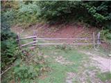 9
9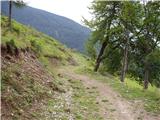 10
10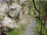 11
11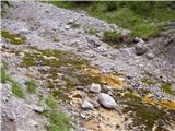 12
12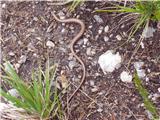 13
13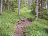 14
14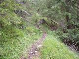 15
15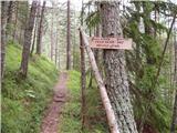 16
16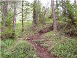 17
17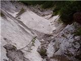 18
18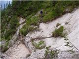 19
19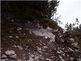 20
20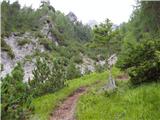 21
21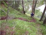 22
22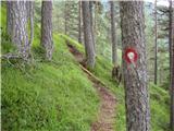 23
23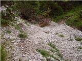 24
24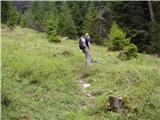 25
25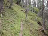 26
26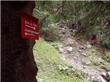 27
27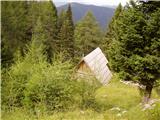 28
28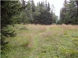 29
29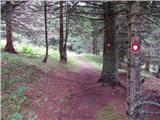 30
30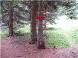 31
31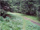 32
32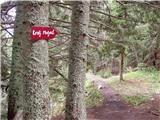 33
33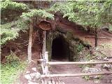 34
34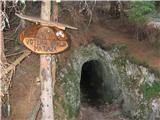 35
35 36
36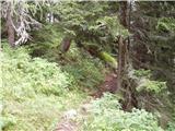 37
37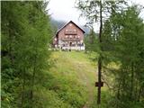 38
38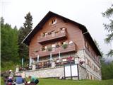 39
39
Discussion about the trip Rudnik v Topli - Dom na Peci
|
| bostjan854. 06. 2010 |
I know this question isn't exactly on the topic above, but still I'd ask, how do you get to Božič's farm, on Sunday I'm going to Peca, and since I'll already be in these parts I'd like to see Rezmanov waterfall and Božič's waterfall.
|
|
|
|
| Petr5. 06. 2010 |
If coming to Črno from Šoštanj, 2 km before Črno center, 1km before the Črno sign, at the bend (house on the right) turn left steeply onto the gravel road (sign Najevska lipa). From Črno, conversely 2 km towards Šoštanj and then right for Najevska lipa. After the Senčnik farm sign right, four right bends follow. In the third left is Rezmanov, in the fourth Božičev slap. 100 m further is Božič farm. Božičev slap is partially visible from the road, Rezmanov is not visible from the road.
|
|
|
|
| Bajtur28. 07. 2011 |
Hello!
Took a family along this trail. Nice trail, but weather was unfortunately wet. Thank God for the poncho. That dangerous crossing over the gully is really bad. The wooden ladder from logs hangs only on one point and will crash into the valley any moment. Recommend crawling on all fours right by the wall.
|
|
|
|
| megalodon25. 06. 2012 |
We would go with the family on this path, the youngest is 4.5 years old accustomed to walking mountain paths, but still interested how it is now with that crossing over the gully (torrent). Is it fixed, safe?
Thanks for any information.
|
|
|
|
| jprim25. 06. 2012 |
This path over the torrent has been arranged some time ago - secured, but you have to watch out for vipers in this area.
LP!
|
|
|
|
| megalodon25. 06. 2012 |
 good news (this about snakes), given that our eager youngsters aren't exactly "tied" to my wife and me on the trail and love to go a bit ahead on their own. Can you give more info about these snakes? Are they common throughout the entire trail or just in this section? good news (this about snakes), given that our eager youngsters aren't exactly "tied" to my wife and me on the trail and love to go a bit ahead on their own. Can you give more info about these snakes? Are they common throughout the entire trail or just in this section? 
(I myself am not really afraid of them  , although I'm not their "fan", it's more for the kids) , although I'm not their "fan", it's more for the kids)
|
|
|
|
| jprim25. 06. 2012 |
I met one in this section, it was right on the path, almost stepped on it, probably elsewhere too, if I tell you that I almost stepped on another one on the path from Komna to planina govnjač, it slithered away at the last moment and then again on the way back from Kuka on the mulatjeri, where I only heard hissing - I was in the air in an instant, my husband saw it, who was behind me both times, he commented, 'that one was still young and was clearing a mouse from the path ... the moral of the story, watch your step on the trail and don't go too fast
|
|
|
|
| rifnik2. 06. 2018 |
Hello! I'm wondering if Dom na Peci has a stamp also for the top of Pece, Kordeževa glava. Thanks
|
|
|
To post a comment you must log in:
If you do not yet have a username, you must first
register.