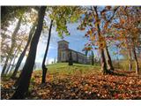
Ročinj - Sveti Pavel (above Ročinj) (via Preval)
Starting point: Ročinj (199 m)
| Latitude/Longitude: | 46,10963°N 13,67107°E |
| |
Route name: via Preval
Walking time: 40 min
Difficulty: easy marked way
Elevation gain: 204 m
Elevation difference along the route: 218 m
Map:
Recommended equipment (summer):
Recommended equipment (winter):
Views: 366
 | 1 person like this post |
Access to starting point:
From Nova Gorica, we drive towards Tolmin or vice versa, we follow the road to Ročinj, where we park at the appropriate place.
Route description:
The starting point of the path to the church of St. Paul is in the center of Ročinj at the church of St. Andrew.
At first the path descends to the spring Zdenc, from here we continue on the left path, after a good hundred meters we get to the stream, where we continue straight and over a small bridge we cross the stream (marked with signpost St. Paul). We continue on a slightly ascending path and at the first junction keep right (marked St. Paul over Preval), from here the path flattens and even descends slightly to a stream, which we cross; ahead, the path begins to moderately rise, and along the path, we can see a water source that almost never dries up throughout the year. After about 10 minutes, we reach Preval, where we turn onto the upper left path, which leads us to the church of St. Paul.
Photos:
 1
1
Discussion about the trip Ročinj - Sveti Pavel (above Ročinj) (via Preval)
To post a comment you must log in:
If you do not yet have a username, you must first
register.