Rifugio Tolazzi - Monte Coglians (Hohe Warte) (via Rifugio Marinelli)
Starting point: Rifugio Tolazzi (1350 m)
| Latitude/Longitude: | 46,59199°N 12,8678°E |
| |
Route name: via Rifugio Marinelli
Walking time: 4 h 25 min
Difficulty: difficult marked way
Elevation gain: 1430 m
Elevation difference along the route: 1450 m
Map: Tabacco 01 1:25.000
Recommended equipment (summer): helmet
Recommended equipment (winter): helmet, ice axe, crampons
Views: 17.748
 | 2 people like this post |
Access to starting point:
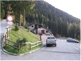
From Trbiž/Tarvisio we go on the highway towards Videm/Udine. We leave the highway at the exit for Tolmezzo. At Tolmezzo we then also leave the road which runs towards the mountain pass Passo di Croce Carnico / Plöckenpass and go towards Villa Santina. In Villa Santina at the roundabout, we go straight following the signs Ovaro, Sappada. We follow this road all the way to Forni Avoltri, where we turn right following the signs Collina. We then follow the asphalt road all the way to the parking lot before the mountain hut Tolazzi.
Route description:
From the parking lot at the mountain hut Tolazzi we continue on the road following the signs Rifugio Marinelli. After a short ascent, we come to a crossroad, where the path towards the mountain hut Lambertenghi-Romanin branches off to the left. We continue on the mountain road, and then in a sharp left turn we leave the road and we continue on a cart track which soon passes into a footpath. Next follows an ascent through the forest by the stream Morareto, and then we again join the mountain road which we follow all the way to Casera Morareet, where there is also a marked crossing. Here we leave the mountain road and go right (towards the east) and we start ascending on grassy slopes with a nice view towards the nearby peaks. After that, the path turns slightly to the left and then follows a little steeper ascent towards the mountain hut Marinelli.
At the mountain hut, we follow the signs Monte Coglians and start ascending through steep meadows. After that, the path turns a little to the left, where we come over a short slightly exposed ridge into an entirely new world. Mighty slopes covered with grass instantly change to bare rock. While crossing the slopes below Coglians we come again to a crossroad, where we go left (path 143), right path (143a) leads to Pilastro del Coglians (2750m). At first, we still cross slopes below Coglians, and then the path turns a little to the right and from the left side the path from the lake Wolayer See joins us. Here we start ascending on a little slippery scree, which in the upper part becomes already quite steep. In the last part, the path turns to the left and then follows a steep ascent with some easy climbing towards a very scenic summit.

Photos:
 1
1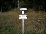 2
2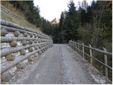 3
3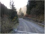 4
4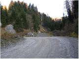 5
5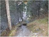 6
6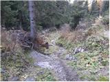 7
7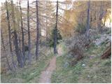 8
8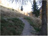 9
9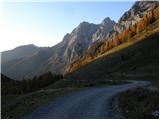 10
10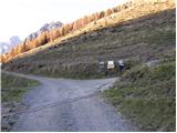 11
11 12
12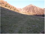 13
13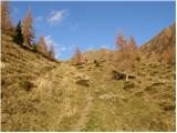 14
14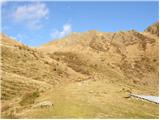 15
15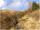 16
16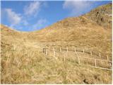 17
17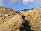 18
18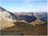 19
19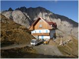 20
20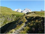 21
21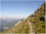 22
22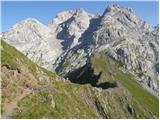 23
23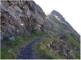 24
24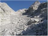 25
25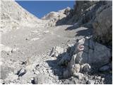 26
26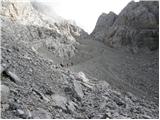 27
27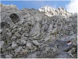 28
28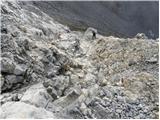 29
29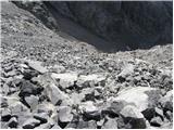 30
30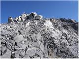 31
31 32
32
Discussion about the trip Rifugio Tolazzi - Monte Coglians (Hohe Warte) (via Rifugio Marinelli)
|
| meko11020. 08. 2012 |
please for some info on path 143 past Rifugio Marinelli to Monte Coglians
|
|
|
|
| ksena20. 08. 2012 |
Two weeks ago my friend and I descended this path and I can say that path 143 itself is not problematic, somewhat annoying (at least for me) is the ascent on scree a bit below the summit. Otherwise the upper photos well show the picture of the path. Good luck!
|
|
|
|
| Shime22. 09. 2016 |
Hello
I'm wondering if there is a mountaineering guide for the Carnic Alps, preferably in English (if not already in Slovenian/Croatian). Unfortunately, I don't know German/Italian so those languages are out of the question for me.
We plan to go to Mt. Coglians, but would like a guide for that part of the mountain world.
Thanks in advance!
|
|
|
|
| JORDAN22. 09. 2016 |
There is also "Guide to Carnic Via Ferratas" by Nada and Binet Mlač. Check the PZS website.
|
|
|
|
| darinka422. 09. 2016 |
Or Karnijska potepanja mountain guidebook--Andrej and Urška Stritar.
|
|
|
|
| jax22. 09. 2016 |
Stritar's guidebook is cool. I have to admit I've never been thrilled with his descriptions, but with this guide it's fine, because they wrote it together with his wife and it's full of funny stories. So the descriptions are so-so, but it's definitely the kind of book that makes your feet itch to go to the mountains as soon as possible.
|
|
|
|
| darinka422. 09. 2016 |
Well, it's very nicely described. I like it. I've had this guidebook at home for quite a few years. I think the authors are no longer so young.
|
|
|
|
| jax23. 09. 2016 |
Well, the truth is that Stritar's descriptions are extremely skimpy and following the path - especially on unmarked terrain - based on those few sentences is very difficult. And I have nothing personal against him.
|
|
|
|
| darinka423. 09. 2016 |
Every eye has its own painter...
|
|
|
|
| turbo23. 09. 2016 |
For the tour, one needs to prepare "comprehensively" and therefore it doesn't hurt to read more than one description of the planned tour. Karnijska potepanja by Stritar is an excellent "magnet" that draws you to those places and is detailed enough to carry out the tour nicely. Of course, some web reading doesn't hurt either, e.g. sentierinatura.it
|
|
|
|
| IgorZlodej24. 09. 2016 |
To reach Coglians via some other route, the description is not enough, so every guidebook comes with a mountaineering map, and see, Karnijska potepanja also recommends this, even with the number for the specific area.
|
|
|
|
| Marko Torelli24. 09. 2016 |
Today via this route to Monte Coglians, the lower part to Marinelli partly on the path, partly on the nice road, which really tempts to do the tour as a duathlon (bike-hike). In the upper part the only nuisance is some scree where we burn some extra calories. The markings are fine. If we have a mountaineering map (for Coglians e.g. Tabacco 09), if we know how to orient it correctly, if we know which path we are on (that every path has its own number is a super useful thing), then we will probably reach the goal. In short, a nice tour, a change from the home environment, where we quickly and quite easily get high. Regards.
|
|
|
To post a comment you must log in:
If you do not yet have a username, you must first
register.