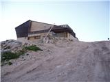
Rifugio Gilberti - Sart / Žrd
Starting point: Rifugio Gilberti (1850 m)
| Latitude/Longitude: | 46,3874°N 13,4734°E |
| |
Walking time: 3 h 15 min
Difficulty: partly demanding marked way
Elevation gain: 474 m
Elevation difference along the route: 700 m
Map: Julijske Alpe - zahodni del 1:50.000
Recommended equipment (summer):
Recommended equipment (winter): ice axe, crampons
Views: 23.681
 | 1 person like this post |
Access to starting point:
From Kranjska Gora via the border crossing at Rateče we drive to Trbiž / Tarvisio. In Trbiž we continue left in the direction of Bovec and follow the road to the junction near Rabeljsko jezero. Here we continue right in the direction of Medvejski preval / Sella Nevea. We follow this road, which is mostly ascending, to the large parking lot at the lower station of the cable car that leads to the Gilberti hut.
Then we buy a ticket and take the cable car to the upper station. From the upper cable car station to the Gilberti hut we have a 5-minute walk along the transport-rescue road.
From Bovec we drive to the border crossing at Predel, from which we descend to the Italian side. Just a little after Rabeljsko jezero we come to the junction, where we continue left in the direction of Nevejski preval / Sella Nevea. Further we follow the above description.
Route description:
From the hut we slightly descend (direction west) into a smaller valley, where there is a path junction. We continue right in the direction of S.Grubia on the path which runs between the main Kanin ridge on the left and Bela peč on the right. The path ahead first ascends gently through the valley, then starts to ascend more steeply and after a few minutes of ascent brings us to an old military fort on the saddle Bela peč. Behind the fort we continue slightly left in the direction of "bivacco" (right Bela peč 30 minutes very demanding path) on an old military mule track, which is already badly damaged. The path, which slightly descends and then ascends again, runs on locally steep slopes, which are somewhat precipitous in places and exposed to falling stones (because the path is wide when dry it doesn't cause problems). The path then brings us to a junction, where the path to Visoki Kanin branches off to the left upwards. We continue on the mule track, which further crosses several gullies that are covered with snow late into summer. The nice and panoramic high mountain path brings us after 2 hours of walking from the hut Gilberti to bivouac Marussich.
Just a few steps from the bivouac we come to pass Peravo, where there is a junction. We continue straight in the direction of M.Sart on the path which starts to ascend towards the west. Soon the path flattens and turns to the right onto the northern side of Vrh Grubij. The fairly level path then brings us to a nice high mountain meadow (Škrbina v Senožečah), where we leave the mule track. We continue the ascent to the right and climb on a poorly visible path to the ridge, where we continue the ascent. The path ahead steeply ascends on a ridge that is somewhat exposed in places. After a half-hour ascent, when we already think that we are on the summit, we step onto the forepeak of Žrd (in fog many think that this is the summit), from which a nice view opens onto our goal. A slight descent follows on a barely visible path which continues on the partly exposed ridge. The ridge then slowly widens from the left side and the path brings us after a few more minutes of ascent to the panoramic summit.
Starting point - bivouac Marussich 2:00, bivouac Marussich - Žrd 1:15.

Photos:
 1
1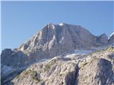 2
2 3
3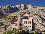 4
4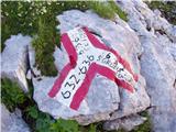 5
5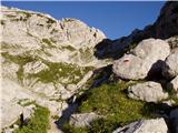 6
6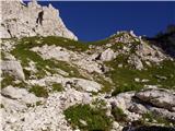 7
7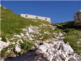 8
8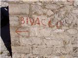 9
9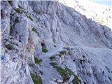 10
10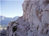 11
11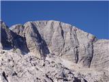 12
12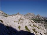 13
13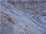 14
14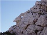 15
15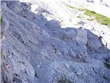 16
16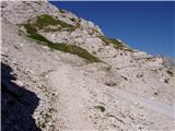 17
17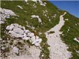 18
18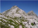 19
19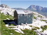 20
20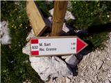 21
21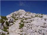 22
22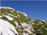 23
23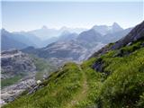 24
24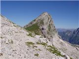 25
25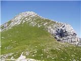 26
26 27
27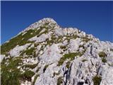 28
28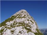 29
29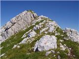 30
30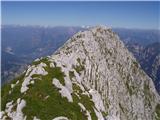 31
31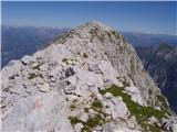 32
32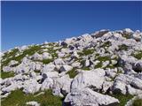 33
33 34
34
Discussion about the trip Rifugio Gilberti - Sart / Žrd
|
| Klin13. 08. 2008 |
You can also reach Rifugio Gilberti from the Slovenian side by taking the cable car to Kanin, then descending via Prevala to the Italian side.
|
|
|
|
| hribuc8522. 08. 2010 |
Hello!
Yesterday I ascended to Žrd with the mountaineering club. Before starting the ascent to the ridge along the grassy slope we noticed a path directly under the southern slope. I'm interested where this path leads.
Thanks for the answer.
Good luck.
|
|
|
|
| Gorazd G22. 08. 2010 |
The path leads under the ridge of Žrd and Ždrinice to the Buja saddle, where the Crasso shelter is, then south to Rezija or north to Reklanica.
The ascent to Žrd from these directions is considerably longer (large elevation difference), but no one will surely regret venturing on this path. I wrote something about it here (on descent) and here.
I recommend the Tabacco map 1:25,000, no. 27
|
|
|
|
| miranm20. 06. 2012 |
Hello,
On Sunday, we plan to head to the mentioned peak with a group of friends. I'm mainly interested in what the path is like, if there are still any snow patches, and if winter gear is needed.
Thanks and all the best!
|
|
|
|
| IgorZlodej21. 06. 2012 |
You'll have to go on foot from the valley, as I think the gondola isn't running yet (check). Otherwise, from the ruins at the Bela peč saddle onwards, towards bivouac Marušič, there may still be snow patches in the gullies, which can be tricky to cross (hard and compacted snow), so an ice axe for kicking steps won't hurt. There is a path along the ridge itself to Žrd.
|
|
|
|
| miranm23. 06. 2012 |
Igor, thanks for the important warning about the gondola. The cable car to the Gilberti hut starts operating on July 21, so we will head to the mentioned mountain next month.
Best,
|
|
|
|
| acjom1. 10. 2014 |
Is the gondola still operating?
|
|
|
|
| cenc3. 10. 2014 |
According to info from Agenzia Regionale Promotour
no longer until the start of the winter season...
|
|
|
|
| darinka425. 07. 2023 07:17:44 |
One is the forecasters' prediction, the other is reality. With the possibility of thunderstorms. We were still satisfied with the tour. Although it didn't turn out as expected. Because at bivouac Marussich, a strong wind started blowing. Then it started raining and there was nothing else but to descend. Still, we did a circular tour, from Selle Neveje along the lower path, which I think bagi has already described. It's quite demanding. To bivouac Goriuda. Then really a beautiful path to the green bivouac Elio Marussich. Which is exemplarily maintained. No trash. Descent along the upper path under Bilo Peč and into the valley. The cable car was running to Rifugio Gilberti yesterday. When we drove past Rabeljsko jezero, there were signs where you used to be able to park for free, saying it's prohibited. It seems they will arrange paid parking, like a bit further at Jerebica.
|
|
|
|
| ejti25. 07. 2023 13:21:33 |
Darinka, is the path to Planina Gorjuda normally passable? I know it's quite demanding and exposed, I'm asking because on the CAI website it says it's "inagibile".
|
|
|
|
| darinka425. 07. 2023 13:29:14 |
Yes, there is a tree on the path in two places. But you can get past it. On one section there is a loose wire rope. Need to be careful. For ascent it seemed suitable to us. For descent we wouldn't choose it. I'm talking about the lower path. We haven't gone on the upper one yet. It's quite long. All around the hill it's beautifully routed. The nicest part for me was from bivouac Goriuda to bivouac Marussich. As far as we saw, people walk these paths. It's fine there because all paths are marked with numbers and there are some signs on the path. Good luck.
|
|
|
|
| ejti25. 07. 2023 13:48:06 |
|
|
|
|
| julya25. 07. 2023 16:25:34 |
Darinka, so how is it at the starting point for Jerebica? And for the valley of Beli potok? I haven't been there for a while and know nothing about the ramp, but I plan to go exactly tomorrow... 
Thanks for the info, best regards.
|
|
|
|
| darinka425. 07. 2023 17:31:06 |
From what can be seen from the road, they have installed a parking meter. It's a paid parking lot. I don't know how it works though.
|
|
|
|
| journeyman25. 07. 2023 19:23:01 |
The parking lot on the gravel area under the road is paid, for cars 2€ per hour and 8€ per day. You just find some widening along the road where you leave the car, just like most others do anyway.
regards
|
|
|
|
| anazala9. 11. 2023 22:00:12 |
Hello. I'm interested if the path that the picture describes as slightly exposed is dangerous or if it would be okay for less experienced people in the mountains. It looks narrower, precipitous. Please explain.
|
|
|
|
| mirank9. 11. 2023 23:13:47 |
I think that for someone who has already been in the mountains sometime, this path shouldn't pose problems. The picture describes a section of the path as exposed, but you have to know that during the war soldiers escorted loaded mules over there. The path is wide enough, no need to go right on the edge. At the saddle V senožečih, we have the option of a circular tour if we follow the mulatiera that gently descends towards Rezija for about 20 min. But the trail from there up is less trodden but well marked. On the return, I recommend also crossing over the top of Grubije
|
|
|
|
| DVas10. 11. 2023 07:06:50 |
I advise against circular, poor markings, tall grass, you can hardly see the path. Tough path. I'm sorry I went circular. Was in mid-August. Also had fog, which made orientation difficult.
|
|
|
|
| Acibujl10. 09. 2025 11:06:33 |
On Saturday, 6. 9. 2025, we parked at Nevea Pass, free parking Slovenia. We went down to the gondola and paid 13 euros round trip to Rifugio Gilberti. From there the path ascends towards the saddle Bela peč, which you reach in less than half an hour. Follow the path left towards bivouac Marussich, about two hours walk on mulatiera. Path suitable for children and dogs, we met quite a few going to the bivouac. We headed to Monte Sart/ Žrd. When you reach bivouac Marussich, continue and when you see the masonry remains from the first war, head onto the path to the left, towards vhu Grubje and descend over the top, follow the cairns, again to a smaller saddle. In front of you is the forepeak of Žrd, Senožeče. At the saddle after a few meters turn right, down from the marked path, marked with red triangles and well traceable. You reach the top of Senožeče. From there enjoy the nice ridge to the top of Žrd! Back to the valley we went the same way. Very scenic, recommend! You visit three two-thousanders...Alternatively, you can skip two and go along the marked path from the Grubje saddle, where the bivouac stands, along path 632 straight ahead and under Žrd head upwards, at least that's what the Tabacco 019 map shows.
|
|
|
|
| lijaneja10. 09. 2025 17:24:58 |
Aci..., can you tell me if you have info on what time the first cable car goes up and the last down?
Thanks for the reply.
|
|
|
To post a comment you must log in:
If you do not yet have a username, you must first
register.