Rifugio Dibona - Tofana di Rozes (Via Ferrata Lipella)
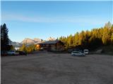
Starting point: Rifugio Dibona (2083 m)
| Latitude/Longitude: | 46,5326°N 12,0703°E |
| |
Route name: Via Ferrata Lipella
Walking time: 5 h
Difficulty: extremely difficult marked way
Via ferrata: C/D
Elevation gain: 1142 m
Elevation difference along the route: 1250 m
Map: Tabacco 03 1:25.000
Recommended equipment (summer): helmet, self belay set, lamp
Recommended equipment (winter): helmet, self belay set, ice axe, crampons, lamp
Views: 33.429
 | 5 people like this post |
Access to starting point:
Access from Gorenjska: Through the border crossing at Rateče or Predel to Trbiž / Tarvisio and then continue on the highway in the direction of Videm / Udine to the Tolmezzo exit. From Tolmezzo we follow the road in the direction of the village Ampezzo and mountain pass Passo della Mauria. The road then descends and brings us to a junction, where we continue left (also right possible) in the direction of Cortina d'Ampezzo. At all following junctions we follow the signs for Cortina d'Ampezzo.
In Cortina d'Ampezzo we then follow the signs for the alpine pass Passo di Falzarego. We follow this ascending road to the place where the road branches off to the right in the direction of the hut rifugio Dibona (the branch-off is at approx. 1700 m). The initially asphalted road then takes us higher to a junction, where we continue on the lower left road (right hut Duca d'Aosta) and follow it to the parking lot for the hut Dibona.
From the Primorska side: We drive on the highway towards Venice / Venezia. Near the town Portogruaro we leave the highway towards Venice and continue right on the highway towards Pordenone. At the next highway junction near Conegliano we continue right towards Belluno. Near Belluno the highway ends, and we continue at the following junctions in the direction of Cortina d'Ampezzo. Further we follow the above description.
Route description:
From the parking lot we continue on a macadam road past a gate. We follow this road to a junction with signposts, where we turn left onto the footpath following the signs »Via Ferrata Lipella«, while right leads path 403 towards the hut Rifugio Giussani. Already after a few meters we are again at a junction. This time we turn right, also following the signs »Via Ferrata Lipella«. The path then crosses the slopes below the mighty south wall of Tofana towards the west in ascent. Initially we ascend through dwarf pines, which are soon replaced by scree. When we approach the wall completely we are again at a junction. We turn left and continue crossing scree towards the west. Right leads the path towards the hut Rifugio Giussani, straight ahead the secured path »Grotta della Tofana«.
After crossing the scree we will be again at a junction, where we turn right following the signs »Via Ferrata Lipella«. Here the path turns slightly towards the north and then we soon enter the climbing section of the path. With the help of brackets and a ladder we ascend almost vertically upwards. Then follows another ascent on the ladder, which brings us to the military tunnel (Galleria del Castelletto). The path then leads for some time through military tunnels, through which we ascend quite steeply a few times. The military tunnel is approximately 500 meters long and ascends 120 meters. From the tunnel we then descend with the help of steel cables onto a somewhat less steep slope below the summit Il Castelletto. Follows crossing on narrow ledges towards the north, after which the path becomes very demanding. A few times we ascend almost vertically with only the steel cable for assistance. Later a bracket assists us on a short overhanging section. The path then continues crossing the west wall towards the north. Mostly we walk on narrow ledges, occasionally ascending steeply. On the path we also descend slightly a few times. Such a path continues all the way to the junction just before the summit Tre Dita (three fingers). It should also be noted that while crossing narrow ledges, water often flows from the vertical walls above us. When snow is still melting higher up, these are real small waterfalls that can thoroughly soak us.
At the junction the path to the summit Tre Dita and further to the hut Rifugio Giussani branches off left, while we turn right where the sign »Cima« directs us. From the junction follows a somewhat longer crossing on the ledge, then the path turns left steeply upwards. A few times we ascend almost vertically along the steel cable, after which the steepness eases slightly. Continuing, the path runs slightly to the right and continues ascending along the steel cable. In between there are also some more demanding almost vertical ascents. The path continues slightly to the right and then brings us to the scree where the secured path ends.
After the ascent over scree we soon reach the ridge where we join the easier path that runs along the eastern side of the mountain.
At the junction we continue right along the ridge, on which we then ascend for some time. In the final section the path moves away from the ridge to the right onto the west side. Here some caution is needed at a few spots as there is quite a lot of scree on the path. Such a path soon brings us to the very panoramic summit.
We descend along the easier path that we joined at the end of the secured path.

Photos:
 1
1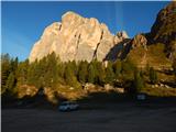 2
2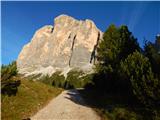 3
3 4
4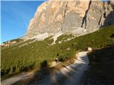 5
5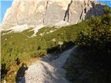 6
6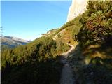 7
7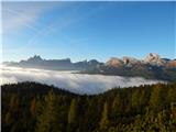 8
8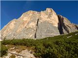 9
9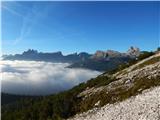 10
10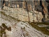 11
11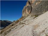 12
12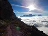 13
13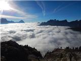 14
14 15
15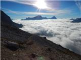 16
16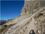 17
17 18
18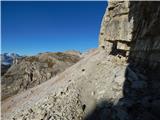 19
19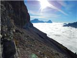 20
20 21
21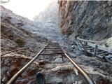 22
22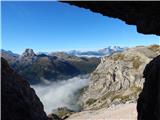 23
23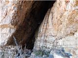 24
24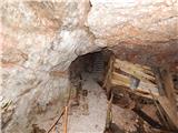 25
25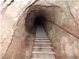 26
26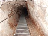 27
27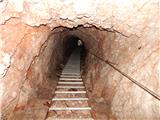 28
28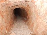 29
29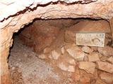 30
30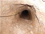 31
31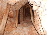 32
32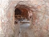 33
33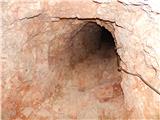 34
34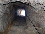 35
35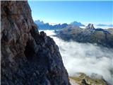 36
36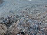 37
37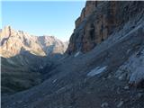 38
38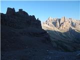 39
39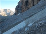 40
40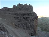 41
41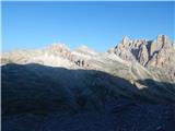 42
42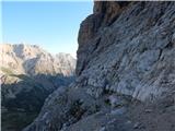 43
43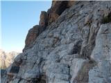 44
44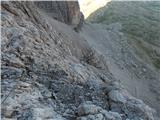 45
45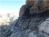 46
46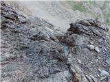 47
47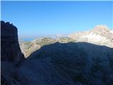 48
48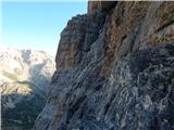 49
49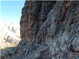 50
50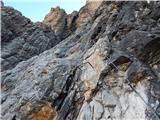 51
51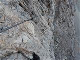 52
52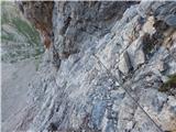 53
53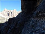 54
54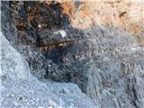 55
55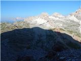 56
56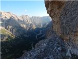 57
57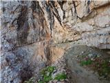 58
58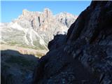 59
59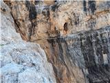 60
60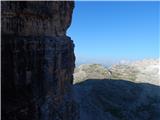 61
61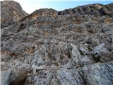 62
62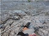 63
63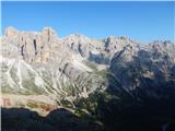 64
64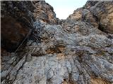 65
65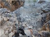 66
66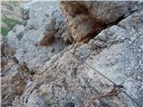 67
67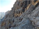 68
68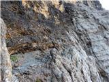 69
69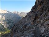 70
70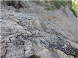 71
71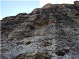 72
72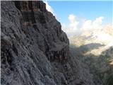 73
73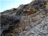 74
74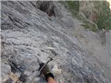 75
75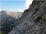 76
76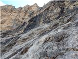 77
77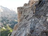 78
78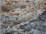 79
79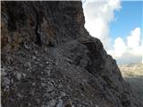 80
80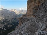 81
81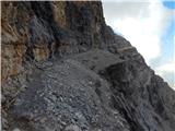 82
82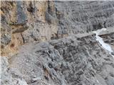 83
83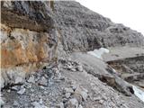 84
84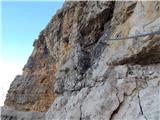 85
85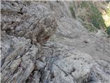 86
86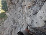 87
87 88
88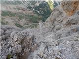 89
89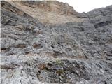 90
90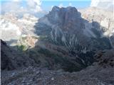 91
91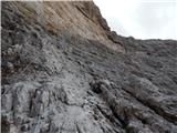 92
92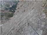 93
93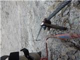 94
94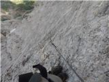 95
95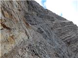 96
96 97
97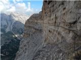 98
98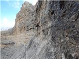 99
99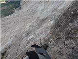 100
100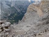 101
101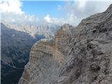 102
102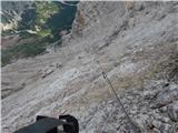 103
103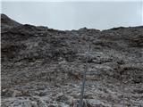 104
104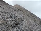 105
105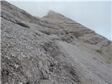 106
106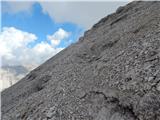 107
107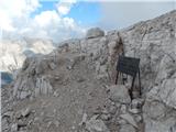 108
108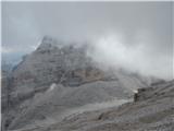 109
109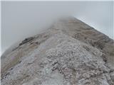 110
110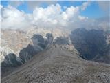 111
111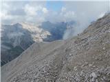 112
112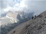 113
113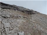 114
114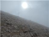 115
115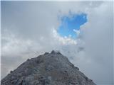 116
116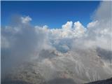 117
117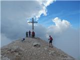 118
118
Discussion about the trip Rifugio Dibona - Tofana di Rozes (Via Ferrata Lipella)
|
| JORDAN12. 08. 2011 |
On Wednesday 10.08.2011 we were on this ferrata. Weather fantastically nice, temperature also suitable -5°. In the lower part of the ferrata, on one of the passages of black rock, the cable was frozen and also the ledge 10m long. To be honest, crampons would be needed there too, because the difficulties were very big. Wherever you stepped it was icy and there, even in case of a slip and staying on the via ferrata set, it's very hard for anyone to help you, because the assistant is also on ice. Probably a 10m rope end would come in handy there, and similarly an additional rope could be useful also on the second jump of the upper part of the ferrata where the cable was also icy and also the rock. At these places there were jams, on the ferrata there were very many people. The upper part of the ferrata is one grade harder than the lower one, but we must also watch out for falling rocks and pieces of ice.
|
|
|
|
| okorn16. 08. 2011 |
First JORDAN thanks for the comment, always useful. On Sunday 14.8.2011 my girlfriend and I also tackled this ferrata, must say Dolomites are awesome, we had great weather and starting early morning we hardly walked in sun except summit ridge. Otherwise ferrata is renovated and well secured, where water runs on ledges it's tricky but nothing frozen, headlamp mandatory  recommend early start otherwise you'll share summit with Czechs we barely escaped them and walked almost whole path alone super. All who love views and have enough fitness (not that bad) treat yourself to this ferrata. Interestingly when we summited 9 people up there 8 Slovenians. From Kranj to Cortina d'Ampezzo 5h drive but passes quick viewing Italian villages and towns. Just warning Cortina d'Ampezzo expensive as are hut stays e.g. room for 8 in Dibona hut 45€ pp + breakfast dinner seems pricey vs Slovenia and you drive to hut by car. Otherwise no bad experiences. Finally thanks to author for detailed nice description. recommend early start otherwise you'll share summit with Czechs we barely escaped them and walked almost whole path alone super. All who love views and have enough fitness (not that bad) treat yourself to this ferrata. Interestingly when we summited 9 people up there 8 Slovenians. From Kranj to Cortina d'Ampezzo 5h drive but passes quick viewing Italian villages and towns. Just warning Cortina d'Ampezzo expensive as are hut stays e.g. room for 8 in Dibona hut 45€ pp + breakfast dinner seems pricey vs Slovenia and you drive to hut by car. Otherwise no bad experiences. Finally thanks to author for detailed nice description.
|
|
|
|
| Kili0230. 07. 2013 |
I'm looking for a comfortable accommodation option in Cortina or surroundings, and I'm interested in your experiences besides campsites, which I already know, their prices are comparable to ours or even lower e.g. in Posočje.
Thanks
|
|
|
|
| DARINKA51. 08. 2013 |
I'm interested in what the road to rifugio Dibona is like, I know there's a height limit, but our motorhome would fit, I'm just curious about the road width because of meeting other cars.
|
|
|
|
| DARINKA51. 08. 2013 |
Kili02, if you have a motorhome, you can overnight at Passo Falzarego without problems, especially now in August it's packed with motorhomes there.
|
|
|
|
| Kili021. 08. 2013 |
No problem with a campervan, I'm interested in experiences of those who have a car or motorbike, i.e. overnight stays like chalets in France, I haven't found anything similar here.
|
|
|
|
| Andreja11. 08. 2013 |
The road to Dibona is narrow, but there are passing places along the way. You meet more cars if you go up in the afternoon when they are returning from tours.
|
|
|
|
| Andreja12. 08. 2013 |
In Dibona this year half-board is 48 eur. That's the only option, just sleeping not possible. Only possible in car or van, a bit away from the hut ...
|
|
|
|
| felix18. 01. 2018 |
I have a similar question as the previous one for Civetta: With which of our protected paths can the ferrata on Tofana be compared? I know that the length of our paths is not comparable to this ferrata, I'm interested in the difficulty.
Thanks and best regards
|
|
|
|
| mirank18. 01. 2018 |
About the difficulty just this much, there are no overhanging sections, otherwise it's better not to write about it, because they say I mislead. We went there end of August 2010? and it was really icy in a few places in the chimneys and also on the ground (sea of ice stalactites and one pond), everywhere where water flows or drips. My opinion is, if there is no fear of heights - with normal strength in arms and appropriate fitness in less than 8h you are back in Dibona. And it's just whether the hardest details on Kopiščarjeva are more demanding or not; otherwise I wouldn't want to compare with our paths; it's all different, length, exposure, altitude, views....Try for example Coglians or Colineto, which are shorter, closer and a bit harder, then it will be clear to you right away , and you can always turn back. And also, if the thing up there seems too demanding, you can easily exit where it says TRE DITA. That's an easy exit to the ridge (indistinct summit with war ruins) and in half an hour you are at koča Giusani. , and you can always turn back. And also, if the thing up there seems too demanding, you can easily exit where it says TRE DITA. That's an easy exit to the ridge (indistinct summit with war ruins) and in half an hour you are at koča Giusani.
|
|
|
|
| don kihott23. 01. 2018 |
These Dolomite via ferrata classics are primarily long and require general psychophysical fitness and luck with the weather... Our ZZP (via ferratas) I think none reaches even an honest C grade on the Austrian via ferrata scale...
|
|
|
|
| rok.si19. 08. 2019 |
We hiked the path on August 15th and got these impressions:
In the first part to the Tre Dita point there is a lot of walking on ledges reminiscent of Kanjavec's, there are also some vertical sections, but the rock is quite grippy and we liked it.
The upper part is, as written, one grade harder. After half an hour of walking on a long ledge it turns steeply upwards and stays that way to the end of the ferrata. Since it rained the previous night the rock, already less grippy than below, was wet, so we had to pull a lot on the cables. At some points it was very problematic for my friend, who is of smaller stature, to progress, as the pegs holding the cable are spaced too far apart. Here we helped ourselves with a sling (gurtna) as an additional step tied to a peg. I recommend everyone of smaller build who sets out on the path after rain to have something similar with them.
All protections are in impeccable condition.
Otherwise a feasible path to a mighty mountain!
|
|
|
|
| pohodnik3336. 09. 2023 21:02:56 |
It's long, nothing to say, and demanding.
In dry weather there was no problem and around 21.8.2023 it was only dripping on the cable and rock in 2 places. There it was more slippery, but those are two short sections.
Tofana di Rozes is a wonderful mountain. Of the Tofanas, it's the most beautiful to me.
|
|
|
To post a comment you must log in:
If you do not yet have a username, you must first
register.