Rifugio Castiglioni Marmolada - Porta Vescovo
Starting point: Rifugio Castiglioni Marmolada (2054 m)
| Latitude/Longitude: | 46,4637°N 11,8622°E |
| |
Walking time: 1 h 15 min
Difficulty: easy marked way
Elevation gain: 424 m
Elevation difference along the route: 424 m
Map:
Recommended equipment (summer):
Recommended equipment (winter): ice axe, crampons
Views: 4.711
 | 1 person like this post |
Access to starting point:
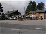
First, we drive to Cortina d'Ampezzo (to here possible over the border crossing Rateče or Predel to Trbiž / Tarvisio and then on the highway in the direction of Vidma / Udine to the exit Tolmezzo. From Tolmezzo we follow the road in the direction of the village Ampezzo and the mountain pass Passo della Mauria. The road then descends and brings us to a crossroad, where we continue left (possible also right) in the direction of Cortina d'Ampezzo. At all next crossroads, we follow the signs for Cortina d'Ampezzo and then we follow the signs for the alpine pass Passo di Falzarego. Already in the first part of the ascent towards the pass Falzarego we will get to a crossroad, where signs for the pass Passo di Giau (2233 m) and Marmolada point us to the left. The road behind the pass Giau starts descending, and we follow it through the settlements in the lower part in the direction of Marmolada or the pass Passo di Fedaia. The road, which then again starts ascending, brings us higher to the pass Fedaia, and we follow it to the other side of the lake, where we park on the parking lot near the hut Rifugio Castiglioni Marmolada.
Access from Primorska: We drive on the highway in the direction of Padova, but only to the highway junction, where we continue in the direction of the region Veneto and Belluno. Near Belluno the highway ends, and we follow the road ahead in the direction of the city Belluno, where at the larger crossroad we continue right in the direction of the town Agordo. From the mentioned town onwards we follow frequent signs for Marmolada or the pass Passo di Fedaia. When we arrive at the mentioned pass we follow the road to the other side of the lake, where we park on the parking lot near the hut Rifugio Castiglioni Marmolada.
Route description:
From the parking lot at the hut Rifugio Castiglioni Marmolada first we carefully cross the road, then we head to the footpath in the direction of "Porta Vescovo" (the start of the path is on the northern side of the lake Lago di Fedaia). The path, which first runs along the road, quickly turns into a wide track that starts to ascend more steeply towards the north. During the ascent over extensive grassy slopes, increasingly beautiful views open up on the lake Lago di Fedaia and Marmolada, the latter additionally adorned by the largest glacier in the Dolomites.
The path, which runs on granitic terrain, then brings us to an abandoned wooden hut, where there is a marked junction. We continue on path 698 (direction Porta Vescovo, left path 601 Viel del Pan), which further ascends somewhat less steeply towards the upper station of the cable car, which we can see already from our starting point. The pleasant and panoramic path then brings us after a good hour of walking to the saddle Porta Vescovo, from which a nice view opens towards the north, where we clearly see Piz Boé.

Photos:
 1
1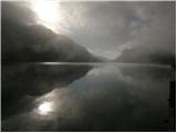 2
2 3
3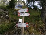 4
4 5
5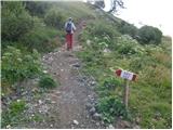 6
6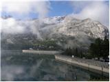 7
7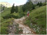 8
8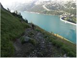 9
9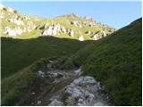 10
10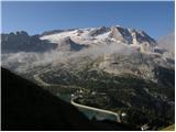 11
11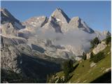 12
12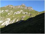 13
13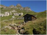 14
14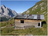 15
15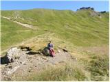 16
16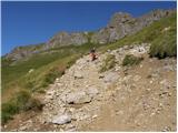 17
17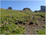 18
18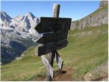 19
19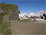 20
20
Discussion about the trip Rifugio Castiglioni Marmolada - Porta Vescovo
|
| VanSims20. 07. 2010 |
The path is a bit poorly marked when it goes through the grassy slope towards the hut. However, you can study the path or see how it winds towards the saddle if you first climb to the hut below the Marmolada glacier, which we will of course obligatorily do if we're already there  . .
|
|
|
|
| francimedved27. 08. 2012 |
I was up here yesterday, wonderful views and full of marmots. The path is well laid out, and even though there aren't many markers, you can't miss it.
|
|
|
To post a comment you must log in:
If you do not yet have a username, you must first
register.