Rifugio Bai de Dones - Rifugio Scoiattoli (on ski track)
Starting point: Rifugio Bai de Dones (1889 m)
| Latitude/Longitude: | 46,5189°N 12,0379°E |
| |
Route name: on ski track
Walking time: 1 h 15 min
Difficulty: easy unmarked way
Elevation gain: 366 m
Elevation difference along the route: 375 m
Map: Tabacco 03, 1:25.000
Recommended equipment (summer):
Recommended equipment (winter): ice axe, crampons
Views: 3.153
 | 1 person like this post |
Access to starting point:
A) From Kranjska Gora over Korensko sedlo to Austria, where at the first larger intersection we continue left towards Podklošter / Arnoldstein and Trbiž / Tarvisio. At the end of the settlement Podklošter, signs for Šmohor / Hermagor direct us right onto a regional road, along which, past the mentioned settlement, we drive to the end of the Gailtal valley, or more precisely to the settlement Kötschach-Mauthen, where we turn right towards the settlement Oberdrauburg. The route ahead leads us over the Alpine pass Gailbergsattel (982 m), after which we descend into the mentioned settlement. After crossing the bridge over the Drava River, we continue left towards the settlement Lienz. In the main roundabout in Lienz, we continue "left" in the direction of the settlement Sillian and Italy. Next, we cross the state border between Austria and Italy, following the main road to the settlement Dobbiaco / Toblach, where we turn left towards Cortina d'Ampezzo. When we arrive in Cortina d'Ampezzo, we follow the signs for the Alpine pass Passo Falzarego. The road above Cortina d'Ampezzo begins to ascend more steeply, and we follow it for quite some time, more precisely to the spot where, just before a sharp right bend, a road branches off to the left, along which we quickly arrive at the large parking lot at the hut Rifugio Bai de Dones. From Kranjska Gora to the starting point is 208 km.
B) From Kranjska Gora over the border crossing Rateče to Trbiž / Tarvisio and further on the highway towards Videm / Udine. We leave the highway at the settlement Tolmezzo, from where we continue driving towards the settlement Ampezzo and further towards the Alpine pass Passo della Mauria (1298 m). The road then begins to descend and brings us into the Cadore valley, where we continue right towards the settlement Auronzo di Cadore. At the next intersections, we follow the signs for Cortina d'Ampezzo. When we arrive in Cortina d'Ampezzo, we follow the signs for the Alpine pass Passo Falzarego. The road above Cortina d'Ampezzo begins to ascend more steeply, and we follow it for quite some time, more precisely to the spot where, just before a sharp right bend, a road branches off to the left, along which we quickly arrive at the large parking lot at the hut Rifugio Bai de Dones. From Kranjska Gora to the starting point is 198 km.
C) From Nova Gorica we drive into Italy and continue on the highway to the settlement Portogruaro, where at the highway junction we turn in the direction of Belluno. We follow the highway to its end (we do not turn towards Belluno), then continue driving towards Cortina d'Ampezzo. When we arrive in Cortina d'Ampezzo, we follow the signs for the Alpine pass Passo Falzarego. The road above Cortina d'Ampezzo begins to ascend more steeply, and we follow it for quite some time, more precisely to the spot where, just before a sharp right bend, a road branches off to the left, along which we quickly arrive at the large parking lot at the hut Rifugio Bai de Dones. From the border crossing to the starting point is approximately 230 km.
Route description:
Left of the lower cable car station that leads to the Rifugio Scoiattoli hut, we will notice a gravel road that begins to ascend along the ski slope. We head onto the mentioned road, which soon turns right and turns into a steep cart track (transport and rescue road for the ski area needs), which ascends along the ski slope. After a few minutes of steep ascent, the cart track temporarily flattens and brings us into a small valley, where we cross a stream. The cart track, which continues to ascend along the ski slope, becomes somewhat steeper again and higher turns slightly to the right, bringing us to the lower cable car station that leads to the Rifugio Averau hut. Here the path, from which beautiful views open up onto Averau and back towards the peaks Lagazuoi Piccolo, Cima Bos, Cima Falzarego and Tofana di Rozes, temporarily flattens and a little higher joins a wider but steep gravel road. The road ascends moderately to steeply for some time more, then brings us to a small intersection, where we continue left in the direction of the Rifugio Scoiattoli hut (straight or slightly right to Rifugio Averau and Rifugio Nuvolau), which we reach in a few minutes of further walking.

Photos:
 1
1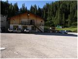 2
2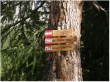 3
3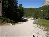 4
4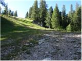 5
5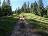 6
6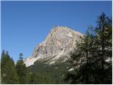 7
7 8
8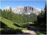 9
9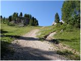 10
10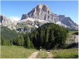 11
11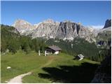 12
12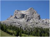 13
13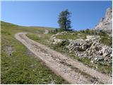 14
14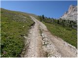 15
15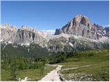 16
16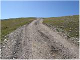 17
17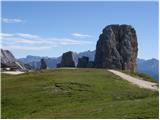 18
18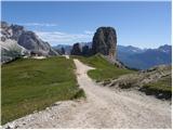 19
19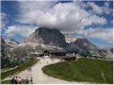 20
20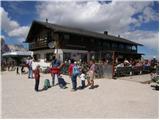 21
21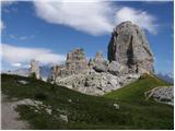 22
22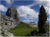 23
23
Discussion about the trip Rifugio Bai de Dones - Rifugio Scoiattoli (on ski track)
|
| mirank26. 06. 2017 |
Here, four variants of the same access are described. In fact, most people climb to Rifugio Scoiattoli from the direction of Rifugio Cinque Torri in 15 min. That one is reachable by public transport vehicles on a nice asphalt road
|
|
|
To post a comment you must log in:
If you do not yet have a username, you must first
register.