Rifugio Auronzo - Monte Paterno (Ferrata De Luca-Innerkofler)
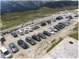
Starting point: Rifugio Auronzo (2320 m)
| Latitude/Longitude: | 46,6122°N 12,2941°E |
| |
Route name: Ferrata De Luca-Innerkofler
Walking time: 1 h 50 min
Difficulty: very difficult marked way
Elevation gain: 424 m
Elevation difference along the route: 480 m
Map: Tabacco 10 1:25.000
Recommended equipment (summer): helmet, self belay set, lamp
Recommended equipment (winter): helmet, self belay set, ice axe, crampons, lamp
Views: 29.858
 | 3 people like this post |
Access to starting point:
Access from Gorenjska: Via the Rateče border crossing we drive to Trbiž / Tarvisio, where we head onto the motorway in the direction of Videm / Udine. We leave the motorway at the Tolmezzo exit and follow the road to the mentioned settlement. From Tolmezzo we continue in the direction of the settlement Ampezzo and mountain pass Passo della Mauria. The road then starts descending and brings us into the Cadore valley, where we continue right (left Belluno and Cortina d'Ampezzo) in the direction of the settlement Auronzo. After a few more km of driving we come to the next major crossroad, where we turn right towards the Misurina pass and Tre Cime (left Tre Crocci pass). From the Misurina pass the road starts descending and quickly brings us to a crossroad where signs for Tre Cime direct us right onto the toll mountain road, which after 7 km brings us to a large parking lot near the mountain hut Rifugio Auronzo.
From the Primorska side: We drive on the motorway towards Venice / Venezia. At Portogruaro we leave the motorway towards Venice and continue right on the motorway towards Pordenone. At the next motorway junction near Conegliano we continue right towards Belluno. Near Belluno the motorway ends, and we continue in the direction of Cortina d'Ampezzo and Auronzo. When the road brings us into the Cadore valley we will arrive at a larger crossroad, where the road to Cortina d'Ampezzo goes left, and to Auronzo right. Here we continue right towards Auronzo. Further, follow the above description.
Route description:
At the Rifugio Auronzo we head onto the macadam road that leads towards the Rifugio Lavaredo slightly to the east. After approximately 20 minutes of walking on a very panoramic road that leads below the mighty walls of Tre Cime we arrive at the Rifugio Lavaredo.
From the hut we continue slightly to the left and start to ascend the scree towards the notch (Forcella Lavaredo) between Monte Paterno and Tre Cime. At the notch, where there is a path junction, we take the wide path that from the notch starts to descend slightly towards the north. To the right branches off the path that leads to Monte Paterno from the south side and path 104, which starts to descend towards the east. On the descent towards Rifugio Locatelli we can choose the lower wide path or the upper somewhat more difficult one, which crosses the slopes below the western wall of Monte Paterno. At the hut, from where there is a very nice view of Monte Paterno and Tre Cime, the two paths join again.
From the hut we continue sharply to the right and start to ascend the northern ridge of Monte Paterno. Soon we enter a tunnel from the First World War. For the ascent through the tunnel we will definitely need a headlamp, as the tunnel is more than 500 metres long. Occasionally wonderful views open up through the windows in the tunnel towards Tre Cime and the lakes Laghi dei Piani. From the tunnel we then reach the eastern slopes of the mountain and soon enter the climbing section of the path. The path first ascends steeply to the right, then turns left and ascends on a well-secured path towards the notch Forcella del Camoscio. At the notch, where our path joins the other two, we go right. With the help of steel cables we ascend over an almost vertical wall. This part of the path is short but demanding, which is why the use of self-belaying is highly recommended. The path then becomes less demanding and through nice passages on the summit slope of the mountain we soon reach the very panoramic summit.

Photos:
 1
1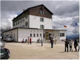 2
2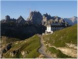 3
3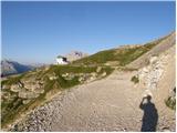 4
4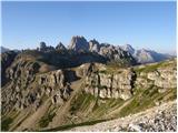 5
5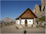 6
6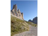 7
7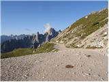 8
8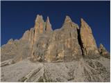 9
9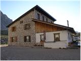 10
10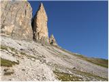 11
11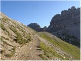 12
12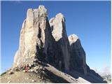 13
13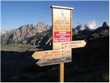 14
14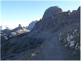 15
15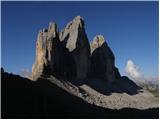 16
16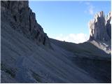 17
17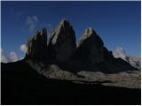 18
18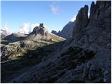 19
19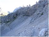 20
20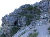 21
21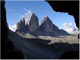 22
22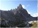 23
23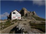 24
24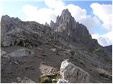 25
25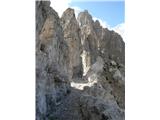 26
26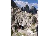 27
27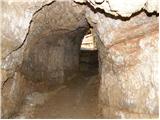 28
28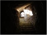 29
29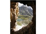 30
30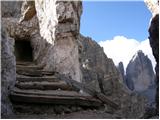 31
31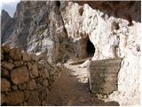 32
32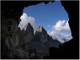 33
33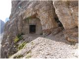 34
34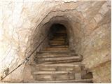 35
35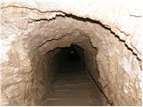 36
36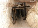 37
37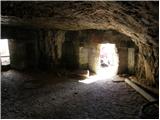 38
38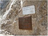 39
39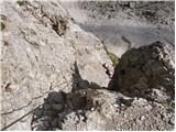 40
40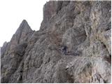 41
41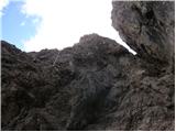 42
42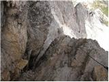 43
43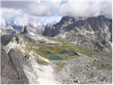 44
44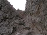 45
45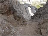 46
46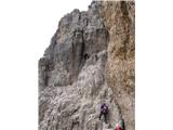 47
47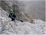 48
48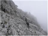 49
49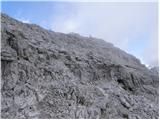 50
50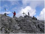 51
51 52
52
Discussion about the trip Rifugio Auronzo - Monte Paterno (Ferrata De Luca-Innerkofler)
|
| Benjamin3. 09. 2008 |
I'm curious how long the drive from Ljubljana to Rifugio Auronzo takes? Thanks.
|
|
|
|
| Tadej3. 09. 2008 |
The drive takes 3 to 4 hours.
|
|
|
|
| benjamin73. 09. 2008 |
Thank you very much. Perhaps some recommendation for a circular tour at this location, the most suitable time of year?
|
|
|
|
| Rok3. 09. 2008 |
Three paths lead to the notch 100 meters below the summit. The path described above along the north ridge, the path along the east ridge and along the south ridge.
Most people do a circular path via the south and north ridges. On the east ridge there is therefore a bit less crowding.
|
|
|
|
| benjamin73. 09. 2008 |
So up the south ridge, down the north one? Thank you very much.
|
|
|
|
| augustus332. 11. 2009 |
The path is very short according to the description. Is a complete self-belaying kit necessary or really highly recommended?
Can I perhaps take a twelve-year-old with me: he is used to pitons and the like?
|
|
|
|
| triglavski2. 11. 2009 |
Google finds everything, just a few clicks needed, some about M. Paterno is also described here: http://www.pzs.si/forum/viewtopic.php?t=4271
Regarding the self-belay kit, everyone should judge for themselves, it's hard to determine. Sometimes only a few meters are critical and belaying boosts our confidence or good feeling. As I saw most were belayed, even many children. But it's a very visited peak.
|
|
|
|
| Bric13. 08. 2018 |
We walked/climbed the path with our 12-year-old son...very well secured via ferrata
|
|
|
|
| Bric13. 08. 2018 |
We climbed/walked the path with our 12-year-old son. Very well secured via ferrata. Big crowd. The ferrata starts at rif. Auronzo and goes to r. Locatelli..it drags, then follows a steep ascent through caves (approx. 0.5 km). Headlamp necessary. Then the ferrata begins. First part without problems, then more demanding (climbing vertical wall). Very well equipped, ascent on one path, descent on another (no waiting, meeting)..then summit (crazy and fantastic views)...down the same path (descent on vertical wall, and further...). For the whole path we needed 4.5 hours.
|
|
|
|
| darinka415. 08. 2018 |
Today we went on this via ferrata. We were a fairly large group of 25. The weather served us excellently. The path or via ferrata is beautifully laid out. In total it was four hours of walking. Many of us today, but no problems on the path. The tunnel we went through is 600 m long.
|
|
|
|
| Gorska.rožica9. 08. 2023 16:15:49 |
Yesterday my boyfriend and I went on this via ferrata. The view from the top is really wonderful. Although many sites say the via ferrata is suitable for beginners, I disagree, as parts are quite exposed and it might be appropriate to start with an easier one. Where there are protections, they are well placed, there are plenty of holds in the rock. But there are sections without protections that are also exposed, and the ground has sand where you can slip easily! Yesterday there was quite a crowd and on such sections it really wasn't pleasant. We went down the same way, on the harder parts the via ferrata is separated for ascent and descent. For the more fearful and for children, it wouldn't hurt to bring a rope to belay them.
|
|
|
|
| felix9. 08. 2023 19:27:49 |
Beautiful area, beautiful summit with wonderful views, the via ferrata is also nicely routed and secured. For the return, you could choose the interesting path from Forcella del Camoscio, which leads to the saddle between Paterno and Tre Cime. If you're in these parts again, I recommend the via ferrata on Torre di Toblin.
|
|
|
To post a comment you must log in:
If you do not yet have a username, you must first
register.