Ravenska Kočna - Mrzla gora (Slovenian way)
Starting point: Ravenska Kočna (1000 m)
| Latitude/Longitude: | 46,385°N 14,5364°E |
| |
Route name: Slovenian way
Walking time: 5 h 45 min
Difficulty: very difficult marked way
Elevation gain: 1203 m
Elevation difference along the route: 1500 m
Map: Kamniške in Savinjske Alpe 1:50.000
Recommended equipment (summer): helmet, self belay set
Recommended equipment (winter): helmet, self belay set, ice axe, crampons
Views: 29.987
 | 3 people like this post |
Access to starting point:
From the Ljubljana–Jesenice highway, take the Kranj–east exit and follow the road ahead in the direction of Jezersko. In Zgornje Jezersko, just a little behind the gas station, we will notice a road that branches off to the right from the main road (direction Planšarsko jezero). The road then leads us past the mentioned lake and behind it steeply ascends for a short time. Higher up, the road flattens and at the beginning of a large meadow loses its asphalt surface. We then follow the macadam road to a marked larger parking lot.
Route description:
From the parking lot, we continue on the macadam road following the signs »Češka koča, Ledine« and after approximately 15 minutes of walking, we come to the cargo cableway.
From the former parking lot at the cargo cableway, we head onto the path that goes between both cableways (the lower station of the cargo cableway to Kranjska koča burned down in June 2015) and then slightly upwards. The path soon leaves the forest and continues through dwarf pines. After some time, the path brings us to a gully named Žrelo. Here we are at a junction, where we continue left (straight ahead the path through Žrelo), and the path then immediately becomes a climbing path. The path is well secured, but caution is still needed due to wet rocks. The path over the shorter wall is in places quite exposed, but full of nice views. When we climb this section, the path returns to the dwarf pines, through which we then ascend on a well-made path. We continue quite steeply upwards and soon the path through Žrelo joins from the right. From here to the Kranjska koča hut, we have only a few dozen steps of easy walking.
From the hut, we continue left towards the east in the direction of Ledinski vrh, Mrzla gora and Rink. The path, which is initially quite level, brings us in a few minutes to a junction, where we take the right path (left is the climbing path to Babe). The path ahead becomes only slightly steeper and brings us to a somewhat more difficult passage over a rocky section. Here a steel cable assists us, but the passage when dry is not difficult. The path then brings us to wide slopes below Ledinski vrh, from which there is a nice view towards the glacier below Skuta, which we can see on the right side. The path then brings us with a moderate ascent to Jezersko sedlo, which borders neighbouring Austria. From Jezersko sedlo, we continue right in the direction of Savinjsko sedlo, which we reach after approximately 15 minutes of traversing. From this saddle, we descend towards Okrešelj. After a few minutes of descent, we come to a smaller emergency bivouac, where we sign the logbook (bivak pod Mrzlim vrhom). We continue descending and soon come to a junction, where the climbing path to Koroška Rinka branches off to the right upwards over scree, while we continue downwards. Soon afterwards, at 1700 m altitude, the path to Mrzla gora branches off to the left. The path initially ascends through sparse dwarf pines and then brings us to a traverse across a rocky slab. Here we put on helmets, as the path ahead is very crumbly and exposed to falling rocks. From the traverse, the path brings us into a gully, which we only cross. Now we enter the climbing section of the path. The path is well protected at the start, but the protections soon run out. There follows an unprotected ascent up a pyramidal slope. Since this section of the path is very steep, watch out for falling rocks. Before stepping onto the top of the pyramid, we have the feeling that this is the summit. But when we step onto the "summit", we see that it is not. There follows a highly exposed traverse of a narrow ledge without protections. At the end of this ledge, the path turns left up a moderately steep wall straight upwards (without protections). Then we walk along the ridge, which is in places quite exposed. The path then turns slightly right and brings us to the summit in 30 minutes over fairly steep terrain.
The path is very demanding and poorly protected. Helmet mandatory.
Ravenska Kočna - Kranjska koča 2:00, Kranjska koča - Savinjsko sedlo 1:15, Savinjsko sedlo - Mrzla gora 2:30.

Photos:
 1
1 2
2 3
3 4
4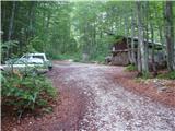 5
5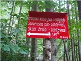 6
6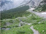 7
7 8
8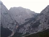 9
9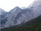 10
10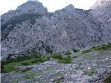 11
11 12
12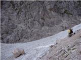 13
13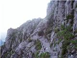 14
14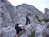 15
15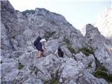 16
16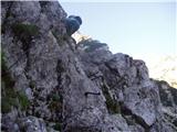 17
17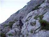 18
18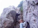 19
19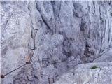 20
20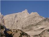 21
21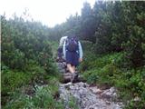 22
22 23
23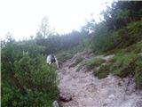 24
24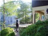 25
25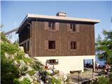 26
26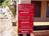 27
27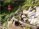 28
28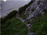 29
29 30
30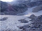 31
31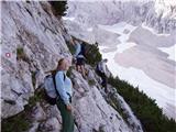 32
32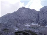 33
33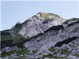 34
34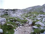 35
35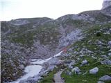 36
36 37
37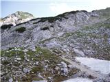 38
38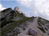 39
39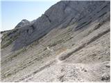 40
40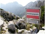 41
41 42
42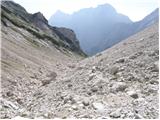 43
43 44
44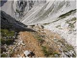 45
45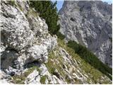 46
46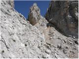 47
47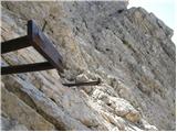 48
48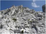 49
49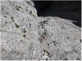 50
50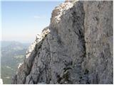 51
51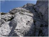 52
52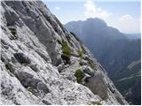 53
53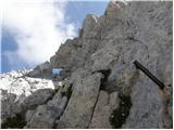 54
54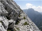 55
55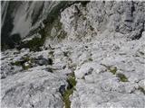 56
56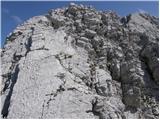 57
57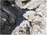 58
58 59
59 60
60
Discussion about the trip Ravenska Kočna - Mrzla gora (Slovenian way)
|
| Gost18. 09. 2006 |
Especially if on the return you also go via the climbing path to Rinke
|
|
|
|
| toncek13. 04. 2007 |
really nice experience, even nicer though if you return via Križ.

|
|
|
|
| Gost30. 07. 2007 |
This mountain is for "nuts". I turned back about 100m from the top because I couldn't stand the pressure anymore.
|
|
|
|
| Ghosting10. 08. 2007 |
Hi! Is it true that the route from Matkov kot is poorly marked? Is better to start from Matkov kot and then go down to Okreselj or vice versa?
|
|
|
|
| Gost10. 08. 2007 |
It's better to start from Logarska dolina and then go over Okrešelj.
|
|
|
|
| Gost10. 08. 2007 |
Hi Gost! According to planinskodrustvo-medvode the route from Matkov kot is well marked but poorly protected. I don't know but some hikers who went down from Mrzla gora to Matkov kot had problems with orientation. So it's probably better come up over Skaf and then go down over Okreselj.
|
|
|
|
| Gost11. 08. 2007 |
Or have they perhaps made a new path that leads from Mrzli dol over Rink to Ledine (the existing one joins the path from Ledine to Rinke or Križ much, much below the summit)?
And nice mountain greetings
|
|
|
|
| Gost11. 08. 2007 |
The climbing path from Mrzli dol to Rinke joins the path from Ledine just above Jezersko sedlo. There is no direct path from Mrzli dol to Rinke. Best regards
|
|
|
|
| Gost16. 10. 2007 |
Hello, the paths through the cold valley to Mrzla gora and to Rinke are in my opinion the most demanding in the Kamnik-Savinja Alps.
But that's just my opinion.
Perfect for everyone who doesn't fear heights, exposure and likes such paths.
Nice mountain greetings!
|
|
|
|
| grahlck3. 06. 2009 |
Is it really true that this path is poorly secured?
|
|
|
|
| mosovnik4. 06. 2009 |
The path is demanding, secured at the most difficult spots, orientationally very demanding in fog, and should be attempted by experienced hikers, best with a knowledgeable person/guide.
|
|
|
|
| velkavrh14. 06. 2009 |
I went along this path a few years ago in a group with three ladies and one gentleman, none of them were spring chickens anymore, but they were good climbers. This is the only natural path in the Kamnik-Savinja Alps without fixed protection except at the beginning, one dangerous section you just ride over. We also had strong wind, which made the ascent even harder. You really need good orientation and to follow the markers well. The descent is equally demanding, on one section we used ropes to help. Adrenaline rush!
|
|
|
|
| stuchlyan26. 06. 2010 |
Yesterday we were up there. Matkov kot - Mrzla gora - Okrešelj. One of the nicest marked hikes I know, especially in Kamniško-Savinjske Alpe. Super atmosphere.
The path past Matkov škaf towards the summit is in poorer condition: faded markings (especially the summit part), some torn and pulled out, but no problems.
The western ridge is a treat with good rock, but quite a lot of loose stones - helmet mandatory. Secured modestly but solidly - just right for those it's intended for: hikers who prefer grabbing rock over metal. Not for family outings. Those up to it will get a nice experience. Rope protections should be tackled by those experienced and proficient in them.
LP Andrej
|
|
|
|
| nevica11. 09. 2011 |
Finally conquered this prominent peak in KSA. The path is quite long from the hut at Ledine but worth every effort. Weather conditions were excellent (dry rock, little scree on ledges), but 100% concentration is needed on the descent. At the top of Mrzla gora we socialized with path markers who were renovating the path from Matkov kot. Enjoyed every step.
|
|
|
|
| frenk4510. 02. 2012 |
I'm interested in which other path this demanding mountain can be compared to.
|
|
|
|
| otiv10. 02. 2012 |
@frenk45 a lot has already been written about this, if climbing exposed walls with little protection doesn't bother you, then there won't be problems on Mrzla gora either. The rock is sharp so gloves are highly recommended, and due to friability definitely a helmet.
|
|
|
|
| ljubitelj gora10. 02. 2012 |
...and definitely don't go when the rocks are wet.
|
|
|
To post a comment you must log in:
If you do not yet have a username, you must first
register.