Rašica - Rašica (Vrh Staneta Kosca) (footpath)
Starting point: Rašica (400 m)
| Latitude/Longitude: | 46,1346°N 14,5043°E |
| |
Route name: footpath
Walking time: 55 min
Difficulty: easy marked way
Elevation gain: 241 m
Elevation difference along the route: 241 m
Map: Ljubljana - okolica 1:50.000
Recommended equipment (summer):
Recommended equipment (winter):
Views: 137.461
 | 1 person like this post |
Access to starting point:
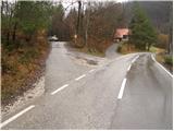
From the Trzin bypass, we head in the direction of Črnuče and follow the road ahead towards Ježica and Gameljne. Just a little before the bridge over the Sava River, we turn right in the direction of the village Gameljne. Further on, we drive through Spodnje Gameljne to the village Srednje Gameljne, where at the intersection we continue right in the direction of the village Rašica. At the beginning of the village Rašica, we arrive at a smaller intersection, where a macadam road branches off to the left upwards, beside which there are hiking markers and a smaller parking lot.
Access to the starting point is also possible from Ljubljana and the Gorenjska motorway.
Route description:
From the parking lot, we continue along the macadam road beside which we parked. After a few minutes of walking, we notice the trail markers, which direct us right onto the footpath that ascends more steeply through the forest. Higher up, the path joins another macadam road, which we follow to the left. After a short ascent along the aforementioned road, we reach a marked junction, where we continue sharply right along the footpath (straight to Dom na Rašici along the road). The path ascends steeply again and joins a rougher forest road just a few steps below the mountain hut.
From the hut, we continue along the wide path, which after a few more steps of gentle walking brings us to the peak Vrh Staneta Kosca, on which there is a lookout tower.
Photos:
 1
1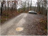 2
2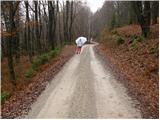 3
3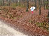 4
4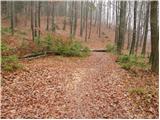 5
5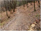 6
6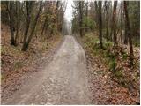 7
7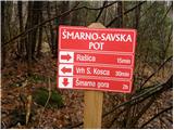 8
8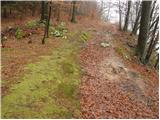 9
9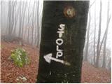 10
10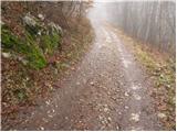 11
11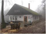 12
12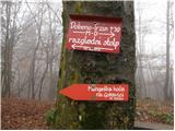 13
13 14
14
Discussion about the trip Rašica - Rašica (Vrh Staneta Kosca) (footpath)
|
| Okmodko7. 12. 2009 |
I suggest going to Rašica from Črnuče near Ljubljana. And stick to the left path through Sračja valley. This path is the most beautiful, it's along the stream and leads through pastures and small forests.
|
|
|
|
| navrhu31. 05. 2010 |
How do I get to the starting point in Črnuče? Please provide a detailed description if possible.
|
|
|
|
| darh17. 01. 2011 |
Given the abundance of trails to Vrh Staneta Kosca, very few are posted here. We went there yesterday from Mengš or Mengeška koča. On the excellently marked trail we had no orientation issues, detailed trail description and our impressions at here.
|
|
|
|
| Okmodko1. 02. 2011 |
There really are few published, but the moderator doesn't want to publish mine! :-( To the starting point in Črnuče you can get at Mercator where the first Mercator is, or from the center left at Mercator along the road and after 200m drive again left at the only house without facade.
|
|
|
|
| balon30. 08. 2013 |
Has anyone gone on this trail after rain? Is it quite muddy?
Best regards 
|
|
|
|
| otiv30. 08. 2013 |
Of course it's muddy for some white Adidas, otherwise it's not that bad.
|
|
|
|
| matic417. 04. 2017 |
From Črnuče you go like this: On the bypass turn into Črnuče, at the first traffic light right, then another kilometer on the road and right into the street "Cesta v Pečale". Drive with the car to the end of the asphalt and park where the macadam starts or 100m further where there is a small parking lot. Follow the macadam road all the way to the village Rašica. The entire trail is very well marked with blazes. The trail mostly goes flat through the valley along the stream between meadows and forest. Only the last 15 min has some ascent towards the village Rašica. The trail is suitable for everyone, picturesque and not muddy. From the village continue right at the church first on asphalt then on macadam. Higher up unmarked shortcuts begin. From Črnuče to the top is an hour and a half.
|
|
|
|
| krempač2. 02. 2020 |
Hello,
please provide information about the accessibility of this starting point (Rašica) by bus and whether and where nearby one can turn around...
Thank you and best regards
|
|
|
|
| Madrid1233. 02. 2021 |
Hello,
The easiest way is to take bus no. 8 to the final stop (Gameljne). From there you still have a good 20 minutes walk to the starting point.
Best regards
|
|
|
To post a comment you must log in:
If you do not yet have a username, you must first
register.