Prtovč - Altemaver (Ratitovec) (via Po(v)den)
Starting point: Prtovč (1011 m)
| Latitude/Longitude: | 46,2275°N 14,1135°E |
| |
Route name: via Po(v)den
Walking time: 1 h 50 min
Difficulty: easy marked way
Elevation gain: 667 m
Elevation difference along the route: 690 m
Map: Škofjeloško in Cerkljansko hribovje 1:50.000
Recommended equipment (summer):
Recommended equipment (winter): ice axe, crampons
Views: 180.307
 | 5 people like this post |
Access to starting point:
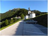
A) First, we drive to Škofja Loka, then continue driving towards Železniki. When we arrive in Železniki, first at the crossroads where the road towards Kropa, Dražgoše and Rudno branches off to the right, we continue straight, then shortly after the Mercator store, or opposite the company Niko d.o.o., we continue right in the direction of Podlonk and Prtovč. We continue on the mentioned road, which starts to ascend more steeply, and we follow the asphalt road entirely to the parking lot on Prtovč, which is located near the church of Marija Pomočnica.
From the main road in Železniki to the starting point is less than 6 km.
B) From Cerkno, Podbrdo or Sorica we drive to Zali Log, then continue driving towards Škofja Loka. When we arrive in Železniki, we leave the main road and continue driving left in the direction of Podlonk and Prtovč. We continue on the mentioned road, which starts to ascend more steeply, and we follow the asphalt road entirely to the parking lot on Prtovč, which is located near the church of Marija Pomočnica.
From the main road in Železniki to the starting point is less than 6 km.
Route description:
From the parking lot, we walk past the church and NOB monument to the beginning of the village, where we come to a well-marked junction. We continue left in the direction of Ratitovec over Po(v)den (slightly right Ratitovec over Razor) on the road which first ascends past houses then turns to the left and slightly descends. The road then changes into a wide cart track that starts moderately ascending through the forest.
After approximately half an hour of walking, we reach the saddle Po(v)den, where there is also a well-marked junction. On the saddle, we continue right in the direction of Ratitovec, on an initially gentle path which ascends through a belt of raspberry bushes, then passes into the forest where it starts ascending more steeply. The path higher up levels out and brings us to a poor forest road, which we follow for only a few dozen meters, then the markers direct us right onto an increasingly steep footpath. The path soon exits the forest and brings us onto steep grassy slopes (in snow great risk of slipping and avalanche), along which we ascend towards the right. Higher up the path past rocky towers brings us onto the main ridge, where it turns sharply to the left and becomes completely level. There follows an easy and pleasant path, along which in 10 minutes of further walking, which takes place on an increasingly panoramic slope, we ascend to the Krekova koča on Ratitovec.
From the hut we continue on the marked path in the direction of Soriška planina. The path first slightly descends to the winter bivouac, where the path from the Pečana mountain pasture joins us from the right, and we continue straight to the watering place for animals, where the path stops descending. Ahead the path starts to ascend more steeply along the pasture fence and after a few minutes of ascent brings us to the eastern forepeak of Altemaver. A short descent follows, then the marked path turns slightly to the right. Exactly at the place where the marked path leading towards Soriška planina turns slightly to the right, we leave it and continue the ascent on a well-visible path in the direction of the Altemaver summit, which continues along the Ratitovec ridge. We then follow this panoramic path to the highest peak of Ratitovec, which we reach after a few dozen steps of further walking.

Photos:
 1
1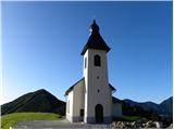 2
2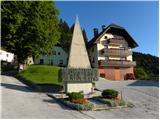 3
3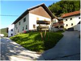 4
4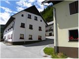 5
5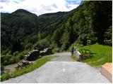 6
6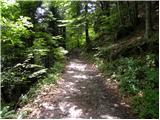 7
7 8
8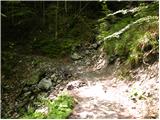 9
9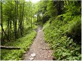 10
10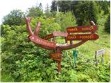 11
11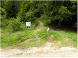 12
12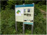 13
13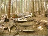 14
14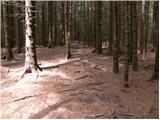 15
15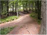 16
16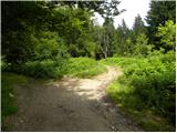 17
17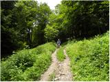 18
18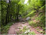 19
19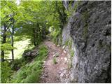 20
20 21
21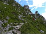 22
22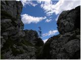 23
23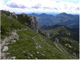 24
24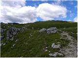 25
25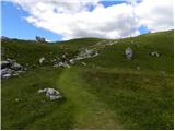 26
26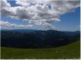 27
27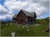 28
28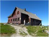 29
29 30
30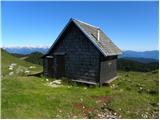 31
31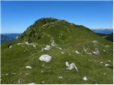 32
32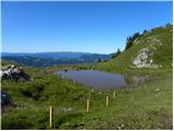 33
33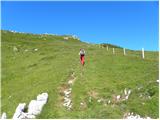 34
34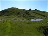 35
35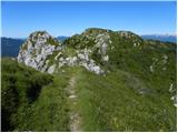 36
36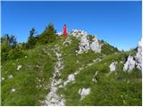 37
37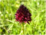 38
38 39
39
Discussion about the trip Prtovč - Altemaver (Ratitovec) (via Po(v)den)
|
| Enka29. 05. 2011 |
Beautiful path, through Povden I liked it much more than the return through Razor.
|
|
|
|
| Lunca31. 05. 2011 |
wonderful... I then went to Gladki vrh, to Altemaver, and even to the end to Kremant... and it was sunny, without a cloud!
|
|
|
|
| Klin2. 06. 2011 |
On Ratitovec it's always nice, especially now when the flowers are in full bloom
|
|
|
|
| Lucy5. 09. 2011 |
Like all my acquaintances, I also set off to Ratitovec. The path itself is easy, suitable for all generations. The hut staff was very friendly, food portions appropriate. It was really nice, even nicer if it hadn't blown so strongly that day. So I recommend taking something warm to wear too.
|
|
|
|
| Kokta6. 10. 2011 |
Too bad there's no sign at the hut where Altemaver is...I found it by guesswork
|
|
|
|
| borovnicka14. 03. 2013 |
And does anyone know if the paths to Ratitovec from Prtovč are still dangerous due to avalanches - via Povden or via Razor? Sunny Saturday ahead...
|
|
|
|
| Daaam14. 03. 2013 |
In the snow the better variant is via Razor (to the right).. I think no problem on Saturday.. lp
|
|
|
|
| GregorC14. 03. 2013 |
Via Razor you go without problems. The path is trodden practically all the way.
|
|
|
|
| borovnicka15. 03. 2013 |
So via Razor Many thanks to both for the reply.
|
|
|
|
| zbe9. 06. 2013 |
Hello,
if anyone found a wallet on the path from Prtovč to Železniki, please let me know. I'll be very grateful.
(Idiot, I put it on the roof of the car ;/)
lp.
|
|
|
|
| ločanka11. 09. 2015 |
Nice trail, very enjoyable especially from the hut on Ratitovec to the summit of Altemauer. Deep and wide views, today along the trail beautifully slightly yellowing grasses, I thought autumn is coming to the land. Back I always like the trail past the mine, the surroundings remind me of Japanese gardens. This part is also enjoyable!
|
|
|
|
| drag_mammut2. 12. 2015 |
so in winter up Razor and back down Povden?
|
|
|
|
| Hammond3. 12. 2015 |
In case of increased avalanche danger, it is best to avoid the path over Povden.
|
|
|
|
| Daša8811. 02. 2016 |
Has anyone visited it recently? What are the conditions? Crampons needed? Up through Povden and down through Razor? Thanks for info
|
|
|
|
| GregorC11. 02. 2016 |
Quite a bit of snow has fallen, so it will be safer via Razor up and down. Just put the small crampons in the backpack.
|
|
|
|
| Olivera30. 09. 2016 |
I suggest changing "Access to the starting point"
from:
"...then the signs for Prtovč direct us right onto the ascending road, which we follow to the large parking lot near the church in the mentioned village."
...to:
"...then the signs for Prtovč direct us right onto the ascending road, which we follow for 5.8 km to the large parking lot near the church in the mentioned village."
Let me explain. The current description suggests that we reach the church very soon after turning, and today I had quite some trouble with that, and without a local I would have had even more. You need to drive another solid 5.8 km uphill to the road.
|
|
|
|
| Tadej30. 09. 2016 |
Thanks for the heads-up, I replaced it with the newer description. I will correct the other descriptions in the next few days.
|
|
|
|
| GregorC2. 10. 2016 |
Olivera, if you had been attentive, on the signs that direct us in Železniki towards Prtovč it is nicely written that it is 7 km to Prtovč.
|
|
|
|
| skledica2. 01. 2017 |
The path is super, nothing icy And top views
|
|
|
|
| planika7712. 01. 2018 |
Has anyone been to Ratitovec recently (from Prtovč starting point)? I'm interested in those sections where the description says "steep grassy slopes (in snow high risk of slipping and avalanche)" - is this description a bit exaggerated or is it really that dangerous now?
|
|
|
|
| enahribovka16. 06. 2018 |
How to go right at Povden saddle if the signpost points left? Error in the description?
|
|
|
|
| Daaam17. 06. 2018 |
The signpost is photographed from the direction of Torka. If you look a bit more closely, you see that the inscription is on both sides of the signpost  . Anyway.. at Povden saddle you turn right if you come from Prtovč . Anyway.. at Povden saddle you turn right if you come from Prtovč
|
|
|
|
| majanezic5. 10. 2018 |
Hi, I'm wondering if the path is suitable for a dog, or is via Razor a better choice in this case?
|
|
|
|
| John5. 10. 2018 |
Hi.
Any path to Ratitovec via/through Prtovč is suitable for a dog, no problem.
|
|
|
|
| majanezic5. 10. 2018 |
Thank you very much for the info.
|
|
|
|
| Borut117. 09. 2020 |
If you're going on this path for the first time, I recommend a circular route with return via Razor.
|
|
|
|
| gpotrebujes10. 01. 2021 |
Hi. Today I forgot my hiking poles at the hut (black-grey, foldable Outdoor Expert). Would some good soul perhaps bring them down to the valley somewhere, anywhere, Železniki or Boh. Bistrica. Of course I'll repay with a round of alcoholic refreshments or coffee. Thanks!
(For any information I'm available at 031859272).
|
|
|
|
| LOL ok10. 01. 2021 |
tomorrow going for sunrise on Ratitovec, if I find them I'll call you :=). best regards
|
|
|
|
| LOL ok11. 01. 2021 |
No poles were there, probably already owned by someone else  lp lp
|
|
|
|
| Mimas23. 01. 2021 |
So through Povden it's not recommended in current conditions, but through Razor it's not dangerous?
|
|
|
|
| bongo24. 01. 2021 |
Through Razor is better, as you don't cross steep and bare slopes like through Povden. But towards Razor there is often slipping in the forest, somewhere halfway from the water reservoir towards the clearing. Generally speaking, one should be cautious. Good luck
|
|
|
|
| Darja22. 02. 2021 |
There is snow through Povden. I was there on Saturday, up through Razor and circular down. I was afraid of avalanches. Luckily we got down nicely. It was nice for me to walk in the snow. Luckily we got down nicely. It was nice for me to walk in the snow.
|
|
|
|
| MiaB.17. 03. 2021 |
Which is the best trail if coming from Primorska to Ratitovec and Krekova hut? Thanks.
|
|
|
|
| orchigu12. 09. 2021 22:11:19 |
Hiked yesterday, circular from Prtovč - up via Razor and down via Povden. Both paths very nice, well-maintained and nicely marked. Via Povden is really more scenic, it was great for me for descending to enjoy the views. Nice to detour to Gladki vrh (5min from the hut), from both peaks there are wonderful views in good weather practically on all our mountains. At Prtovč there is a fairly large and nicely arranged parking, parking fee 2€ for the whole day, paid by SMS or app (that pink thing that's now common at exits - easypay or easypark or whatever). Great food at the hut, quite crowded but in my opinion they deserve the title of best hut.
|
|
|
|
| mikkeni3. 02. 2024 18:36:20 |
How is this trail these days? Need crampons or does it soften up in the afternoon so no need?
|
|
|
|
| gasperg3. 02. 2025 12:55:38 |
Hi, how is the path? Would go on Wednesday morning.
Ice axe/crampons??
Thanks, best regards!
|
|
|
To post a comment you must log in:
If you do not yet have a username, you must first
register.