Pri Žagi (Javorniški Rovt) - Mala Boncla (Bavha)
Starting point: Pri Žagi (Javorniški Rovt) (885 m)
| Latitude/Longitude: | 46,4539°N 14,0975°E |
| |
Walking time: 30 min
Difficulty: easy unmarked way
Elevation gain: 246 m
Elevation difference along the route: 246 m
Map: Karavanke - osrednji del 1:50.000
Recommended equipment (summer):
Recommended equipment (winter): ice axe, crampons
Views: 8.768
 | 3 people like this post |
Access to starting point:
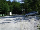
From the highway Ljubljana - Jesenice we take the exit Lipce, and then turn right towards Jesenice. In the settlement Javornik at the first traffic-light intersection we turn right (direction Lj.) towards Koroška Bela. At the next intersection with traffic lights we turn left, and soon once again left towards Javorniški Rovt. After a few kilometers of driving uphill (when we have already arrived in the mentioned village), in a sharp left turn the macadam road branches off straight ahead towards Dom Trilobit (sign). Right before that spot on the right we notice a smaller parking lot, where our starting point is.
Route description:
From the starting point we continue a few meters on macadam, then we come upon marked signposts with inscriptions Valvazor and Gajškova pot. Here we turn right, but do not continue following the blazes (right over the bridge), instead straight uphill on the cart track. Soon we reach the next bridge, where we cross the stream, the path (cart track) turns left uphill. For the next 15 minutes of walking we follow the main cart track, which means we ignore three right turn-offs of the cart track. On the left side of the path we will be able to notice the sign "Dom Trilobit" twice.
Only when the path ascends somewhat more steeply do we come to a fork in the cart track, where we turn right (left is the path to the mountain pasture Stamare). The cart track now turns increasingly to the right, first ascends steeply, then levels off briefly, and ascends somewhat again towards the (forested) saddle between both Bonclas. Still before the path levels off again before that spot, we turn right from it onto a less noticeable trail that leads west onto the ridge of Mala Boncla. When we step onto it, the partly gravelly path overgrown with tree roots quickly brings us to the first steel cable. Here the ascent ends. Then follows the second steel cable, which serves us as a railing. Here, at the top, we will come upon an interesting, standing, dried tree.

Photos:
 1
1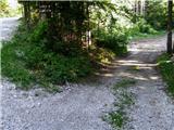 2
2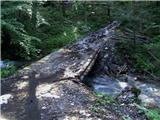 3
3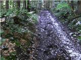 4
4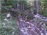 5
5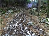 6
6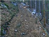 7
7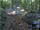 8
8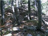 9
9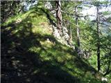 10
10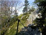 11
11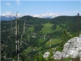 12
12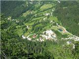 13
13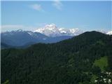 14
14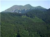 15
15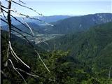 16
16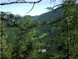 17
17
Discussion about the trip Pri Žagi (Javorniški Rovt) - Mala Boncla (Bavha)
|
| klavdipo28. 05. 2009 |
Heinz, please provide info if at the top there is also a summit logbook with stamp or just a dry tree?
LP
|
|
|
|
| heinz28. 05. 2009 |
No, there is unfortunately no stamp box there. Still worth the visit (views).., especially if you're nearby.
LP, enjoy! Heinz
|
|
|
|
| Majdag7. 02. 2011 |
...Mala Boncla... Super, it's worth going there specifically, not just passing by. Fantastic views, in weather like today. I noticed some markings (blazes) in the forest section of the trail. Snow surprised me. There's still quite a bit, and it was frozen. I'm wondering, Heinz, if going straight along that cart track (before turning right towards Boncla), you also reach Stamare. And if you go along the ridge-saddle, do you reach Velika Boncla, right Majda?
|
|
|
|
| heinz7. 02. 2011 |
Yes Majda, you're asking correctly. The markings in the forest indicate exactly the path (for Kraševec (description on Hribi))-to Stamare.
And that's true too, if at the saddle between the two Bonclas you continue straight or more to the left, you reach V. Boncla. There aren't many views there, because it's not very open anywhere. The steep cart track ends a bit above V. Boncla, but if you continue left, you come across a steep hunting path through scree that also leads to Stamare.
A bit before the end of the aforementioned cart track, the path branches off to a smaller gully with a small hut. From there, go right to the ridge or edge of V. Boncla.
To Mala B. you can also go via the path that leads there along the left side of its northern cliffs. You come to it if you branch right a bit before the fork to Stamare, but I must add that it gets lost or is quite overgrown.
|
|
|
|
| Majdag13. 04. 2016 |
... On this panoramic summit it's always nice. Snow only remnants left, auriculas not yet.
|
|
|
|
| Majdag2. 03. 2022 20:12:05 |
The path is all icy, only a short section is dry. Even through the bushes it's icy under a thin layer of snow. At the top everything is arranged; new benches, a box with the logbook, I didn't check for the stamp, nice. And great views in all directions. Nice viewpoint and it's close. In the snow the path is nicely traceable.
https://jelenkamenmajdag.blogspot.com/2022/03/mala-boncla.html
|
|
|
|
| grega_p11. 03. 2022 00:15:29 |
The junction where the path to Planina Stamare branches left is exactly where the second yellow sign (on the left) for Dom Trilobit is located.
There are two junctions to Mala Boncla, at least based on my experience today. The first is earlier, where the "gully" between the NW subpeak and the summit is indicated. It's actually more of a poorly visible goat path, so caution is needed and hands should be used a bit, but it's doable. The rock on the subpeak offers views but is quite exposed. I descended along the fixed cables by the ascent described above.
I also recommend a detour to Dom Trilobit (lower sign along the path), as Javornik stream is currently very lively and the little pond is an attractive addition. For info: ascent past the subpeak took about 40 min, descent past Dom Trilobit 30 min.
The trail is still quite icy in places, especially in steep shady forest sections. Poles recommended.
|
|
|
|
| grega_p11. 03. 2022 00:20:56 |
And of course big thanks to Heinz for the description and sharing such beautiful, somewhat hidden and therefore peaceful viewpoints that marked trails don't lead to.
|
|
|
To post a comment you must log in:
If you do not yet have a username, you must first
register.