Pri Mlinču - Mangartska koča (by road)
Starting point: Pri Mlinču (1094 m)
| Latitude/Longitude: | 46,4235°N 13,5935°E |
| |
Route name: by road
Walking time: 2 h 45 min
Difficulty: easy marked way
Elevation gain: 812 m
Elevation difference along the route: 812 m
Map: TNP 1:50.000
Recommended equipment (summer): lamp
Recommended equipment (winter): ice axe, crampons, lamp
Views: 38.458
 | 4 people like this post |
Access to starting point:
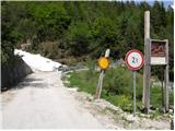
a) From Kranjska Gora we drive across the Rateče border crossing to Trbiž/Tarvisio. In Trbiž we continue left in the direction of Bovec and follow the road to the intersection near Rabeljsko jezero. Here we continue straight further in the direction of Bovec (right Nevejski preval/Sella Nevea) and the road takes us higher to the Predel border crossing. Then we start descending, but only to the intersection where signs for Mangartsko sedlo direct us left. Here we turn left and then soon park at the parking lot by the road.
b) From Bovec we drive towards the Predel border crossing, but only to the place where signs for Mangartsko sedlo direct us right. The continuation follows the description above.
Route description:
From the parking lot we continue along the road, which soon takes us to a mighty landslide. Here the road turns right, crosses the landslide and on the other side steeply ascends along the edge of the mentioned landslide. Further, a side road branches off to the left from the main road, leading towards Mangartska planina (possibility of ascent by footpath). The road then turns slightly to the right and takes us to the first tunnel (a flashlight will be helpful). The increasingly scenic and picturesque road then takes us through numerous tunnels and serpentines to the next intersection, where we continue left in the direction of Mangartska koča (straight Mangartsko sedlo). After another 5 minutes of walking on the narrow and steep road we reach the mountain hut, from which there is a beautiful view of Mangart.
The path is recommended only for rainy days (without thunderstorms), in good weather and snow-free conditions the ascent by footpath is much nicer.

Along the route: Gornji stan (1560m), Prehod (1767m), Vzletišče Mangart tunel (1787m)
The trip can be extended to the following destinations: Mangart
Photos:
 1
1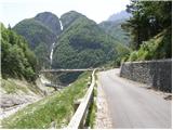 2
2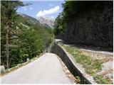 3
3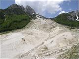 4
4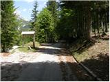 5
5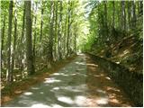 6
6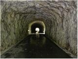 7
7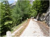 8
8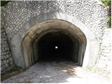 9
9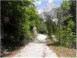 10
10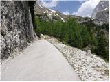 11
11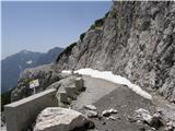 12
12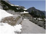 13
13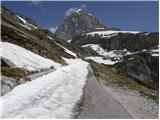 14
14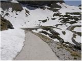 15
15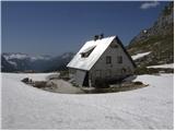 16
16
Discussion about the trip Pri Mlinču - Mangartska koča (by road)
|
| ROBERT22. 08. 2006 |
I have a lot of stamina but that day when I headed to the saddle by bike I almost lost my love for life!
|
|
|
|
| ben27. 07. 2008 |
Conditions on the road are excellent, well-maintained road, toll for motorcycles and cars is 5€. LP
|
|
|
|
| S.Marko30. 07. 2008 |
Does anyone know if transport from Ljubljana is organized for the cycling ascent to Mangartsko sedlo? Best regards.
|
|
|
|
| S.Marko30. 07. 2008 |
Add. It's for the August race. Best regards.
|
|
|
|
| Johny777. 06. 2009 |
I plan to go up here by bike to explore a bit of Posočje.
|
|
|
|
| Mate078. 06. 2009 |
How much do you have to pay for the toll?
Do they collect it every day and all day?
|
|
|
|
| LUNA28. 06. 2009 |
On Thursday 25.6 we took advantage of the sunny-cloudy day for a trip around Bovec and surroundings. Among other things, we also headed towards Predel. There we met a group of workers who told us that the road to Mangartsko sedlo is completely closed due to a landslide in the middle of the roadway, which will require longer remediation. I'm interested if anyone has been on foot on the mentioned road these days or how long it takes from the junction for M.sedlo to Mangartsko sedlo? longer remediation. I'm interested if anyone has been on foot on the mentioned road these days or how long it takes from the junction for M.sedlo to Mangartsko sedlo?
|
|
|
|
| viharnik28. 06. 2009 |
To the hut by road it's about 3 hours, if you take the ridge shortcut then about half an hour less.
|
|
|
|
| viharnik28. 06. 2009 |
In spring I had no idea I was stepping on such a destroyed path. Judging by the pictures, personal vehicles definitely can't go through here. For the approach to the saddle there are still nice and forgotten paths through Jačke. Let's go on foot!
|
|
|
|
| zmp229. 06. 2009 |
How is the approach from Mangartska dolina (blue line)? What is this path to bivouac Nogara like, and which direction is more logical/safer from Nogara to the top, blue or red?
|
|
|
|
| zmp229. 06. 2009 |
Another picture of the path
Mangart
Interesting, I can't correct the previous comment (or I can't find where to do it)
|
|
|
|
| Murglovc29. 06. 2009 |
Best to combine, blue below, red above. Red in the lower part is ferrata and is currently closed!
|
|
|
|
| turob13. 07. 2009 |
I'm interested if the situation on the road to Mangartsko sedlo regarding avalanche removal has improved in terms of drivability..
|
|
|
|
| triglavski13. 07. 2009 |
Unchanged and according to latest info they should finish the works around 15th August.
|
|
|
|
| ljubitelj gora7. 10. 2010 |
I'm wondering if the path from Požarje (on foot, not by car) is well marked... I wouldn't want to drive so high up and then only have about an hour to the top.
|
|
|
|
| aina29. 07. 2011 |
We would like to climb to Mangartsko sedlo, but not on the road, but on footpaths.
Where are possible starting points and are those paths marked?
Thanks for info..
|
|
|
|
| MANGRT29. 07. 2011 |
aina
park the car at the junction of the road to Mangart (roughly at Mlinču). You walk on the asphalt road about 700m to the first bridge, where you go along the Mangartski stream to the alpine pasture. From the pasture onwards a wide path leads through the forest to the upper hut. There you cross the road too. From here the path is trodden by sheep and narrower. You reach the road again, where you can turn left into the forest, or continue on the road through a short tunnel and before the next one turn right. After 10-15 minutes you're back on the road, where you continue to the hut or turn left earlier and cross the meadow past the hut ruins to the saddle.
the path is marked and easy with lots of enjoyment
|
|
|
|
| MANGRT29. 07. 2011 |
aina forgot to add that the path is drawn - Julijske Alpe western part 1:50000
|
|
|
|
| francimedved10. 06. 2016 |
I'm wondering when the hut on the saddle is open? Thanks.
|
|
|
|
| GregorD12. 06. 2016 |
From the news 7.6.2016 PZS, GRZS and Police for safer visits to the mountains, the following is evident:
On June 25, the huts under Triglav will also open, Dom Planika and Koča na Doliču, and presumably Koča na Mangartskem sedlu.
|
|
|
To post a comment you must log in:
If you do not yet have a username, you must first
register.