Predkonjska - Dom na Kisovcu (through Konjska dolina)
Starting point: Predkonjska (470 m)
| Latitude/Longitude: | 46,2836°N 14,6155°E |
| |
Route name: through Konjska dolina
Walking time: 3 h
Difficulty: partly demanding unmarked way
Elevation gain: 805 m
Elevation difference along the route: 900 m
Map: Grintovci
Recommended equipment (summer):
Recommended equipment (winter): ice axe, crampons
Views: 4.966
 | 5 people like this post |
Access to starting point:
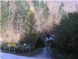
Through Kamnik we drive in the direction of Kamniška Bistrica and the cableway to Velika planina. If we will return on the path past Sveti Primož, we park in Stahovica and continue on foot; otherwise we drive a good 2 km further to the inn Pri gamsu, where we park. We continue on the road over Konjski potok (immediately below the road it flows into Kamniška Bistrica) and turn right on the road past the house.
Route description:
The road changes into a cart track which leads us through the gorge. Past the shooting range we go to the remains of the bridge, where the cart track ends. Here we cross the stream and continue on the left side just by the stream. The path is quite overgrown. When we can't go further anymore, we again cross the stream. From here on the path mostly isn't marked, but orientation is easy, because we follow the stream. We cross side gullies (in some parts demanding). When the right bank of the stream (on our left side) becomes easier to pass, we ascend onto the forest ridge and straight upwards along it, where we encounter a footpath which branched off immediately at the remains of the bridge (but the beginning is hardly noticeable, because everything is very overgrown). We ascend in the same direction until at approximately 1000 m we reach the hunting path which leads from the bottom cableway station to Velika planina to the mountain pasture Kisovec. On it to the right. The path runs gently diagonally across the slope, occasionally rising in zig-zags. We cross several gullies, the last is the gully of Konjski potok. From here steeply in zig-zags (Gamsove streže) to the marked path Stahovica - Velika planina. Across it we descend along the marked path to the mountain pasture Kisovec and to the mountain hut.
The described path is impassable at high water.

Photos:
 1
1 2
2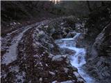 3
3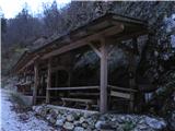 4
4 5
5 6
6 7
7 8
8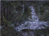 9
9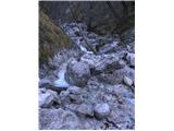 10
10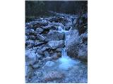 11
11 12
12 13
13 14
14 15
15 16
16 17
17 18
18 19
19 20
20 21
21 22
22 23
23 24
24 25
25 26
26 27
27 28
28 29
29 30
30 31
31 32
32 33
33 34
34 35
35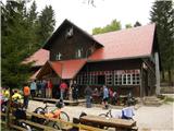 36
36
Discussion about the trip Predkonjska - Dom na Kisovcu (through Konjska dolina)
|
| andi225. 01. 2015 |
This path caught my eye when I repeatedly wondered where this narrow valley at the entrance to Kamniška Bistrica leads. Today I hiked it to the start of the crossing (picture 20), where I turned back due to frozen leaves, ice, and powder snow. The description is good, traceability and difficulty are not problematic, but you often need to switch sides along the stream . On the ridge above the stream, the path is quite visible. Overall impression - something really remote and quiet, complete opposite of Mala planina from the parking before Calcita. . On the ridge above the stream, the path is quite visible. Overall impression - something really remote and quiet, complete opposite of Mala planina from the parking before Calcita.
|
|
|
To post a comment you must log in:
If you do not yet have a username, you must first
register.