Predel - Cime del Mughi / Nemške glave
Starting point: Predel (1156 m)
| Latitude/Longitude: | 46,4186°N 13,5783°E |
| |
Walking time: 1 h 30 min
Difficulty: partly demanding unmarked way
Elevation gain: 441 m
Elevation difference along the route: 441 m
Map: Tabacco 019, Julijske Alpe - zahodni del 1:50.000
Recommended equipment (summer):
Recommended equipment (winter): ice axe, crampons
Views: 13.102
 | 3 people like this post |
Access to starting point:
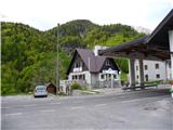
From the Ljubljana direction on the Gorenjska motorway to the Hrušica exit. From there on the regional road to the Rateče border crossing and further towards Trbiž. A little before it, the road branches off to the left towards the Predel border crossing. We drive through the mining settlement Rabelj and a few kilometres further to the Predel / Sella Nevea crossroads. We turn left and after a few more kilometres arrive at the border crossing. From Ljubljana to Predel we need approximately 1 hour and 30 minutes. We park on the Slovenian side, where there is enough space.
We can also reach the starting point from the direction of Bovec.
Route description:
The beginning of the unmarked path is on the Italian side of the border crossing immediately after the border stone (obelisk) in the direction of Jerebica. The path by the edge of the meadow is not visible, but it appears when we enter the forest. It is clearly visible and good enough not to cause problems, although it has seen better times. In two rocky gullies caution is needed so that we do not overlook the continuation (see pictures). The path to the summit plateau is steep, but beautiful views open up far around with increasing height. On the summit plateau, dwarf pine thickets begin, which require some crouching, but the path is still followable. The highest peak is the last in the chain and has a fortification on the right edge. We reach it via a slightly more demanding notch, which has a detour on the right side. This detour is not substantially easier, but starts in a gully just before the notch. To the summit there is then some more ascent and we arrive at a clearing in the middle of the dwarf pines. Because there is no other view here than on Jerebica, we head right towards the fortification. The access is not entirely easy due to the overgrowth of the path, but it can be followed with a little effort. It runs from the clearing onwards along the border of deciduous trees and dwarf pines. When we reach the fortress, an exceptional view opens towards Rabelj and Nevejski preval / Sella Nevea.
On the return, greater caution is needed in following the path.

Photos:
 1
1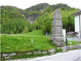 2
2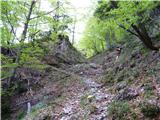 3
3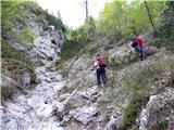 4
4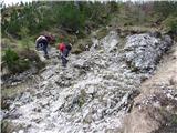 5
5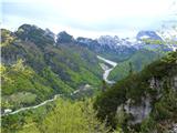 6
6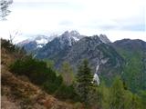 7
7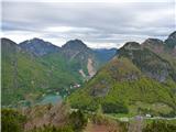 8
8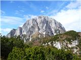 9
9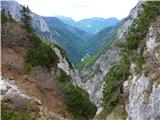 10
10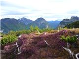 11
11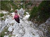 12
12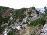 13
13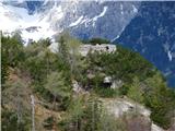 14
14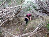 15
15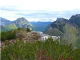 16
16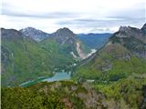 17
17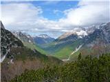 18
18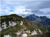 19
19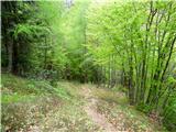 20
20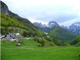 21
21
Discussion about the trip Predel - Cime del Mughi / Nemške glave
|
| Loerst9. 05. 2018 |
To the otherwise completely correct description, I would only add that today (May 18) the path is not visible on quite a few sections and it is very easy to miss it (up and down). There are also a few spots where it is somewhat slippery even in dry terrain. Otherwise nothing that an average hiker couldn't solve with a bit of improvisation (well, you have to go up, possibly through some gully or a little on your own around), but since it is quite overgrown up there, deviating from the path quickly avenges itself with crashing through scrub, which then no longer makes for such a pleasant trip as it could otherwise be.
|
|
|
|
| keti111. 05. 2018 |
I agree that the path is not easy to follow and I wouldn't recommend it to less experienced hikers. About 15 years ago I was up there several times, always without problems. Last time in 2016, however, I got quite confused at a few spots, and even on the way back it wasn't easy. In no case suitable in fog.
|
|
|
|
| inferno66630. 07. 2019 |
Last week I went on this path with my better half. The path is nicely traceable at the beginning, then we got off track at some point. The path between picture 4 and 12 we did off-trail and partly on a path not described here  . .
For the return, we found a path that in my opinion is the easiest also for ascent. At the notch we turned into the valley towards Rabeljsko jezero. The path first goes on the left side, later on the right side of the stream. It joins the earlier described path 10 min before the starting point. There are no technically demanding sections on the path.
We noticed that the path is marked with a branch, which we missed. The junction appears after approx. 10-15 min from the start. I attach a picture.
|
|
|
|
| skiro12331. 08. 2020 |
I hiked the route a few days ago and some information is not quite accurate:
1) The descent to the notch is demanding, at least as much as e.g. Mali Draški vrh, so the label demanding unmarked path would be more appropriate.
2) The summit described as "summit plateau" is marked as Veliki Koteh on some maps - to there the label partly demanding is quite appropriate.
2) For the route, comparable to other walking times, it takes 2 hours, unless Veliki Koteh is meant.
3) Access from the top of Nemške glave to the fortification is not demanding.
This is probably a misunderstanding due to ambiguity about the summit name. Peakvisor and opencyclemap have the summit marked as Veliki Koteh (1578), pespoti.si as Nemške glave, without height label. I suggest to admin to correct either the summit name (and height) or in the description.
|
|
|
|
| Loerst29. 03. 2021 |
Veliki Koteh (1578 m) and Nemške glave (1597 m) are two different peaks at practically the same location, air line distance approx. 300 m or a few minutes due to the intermediate descent into the saddle. Veliki Koteh is still before the descent into the saddle and Nemške glave are behind it, closer to Jerebica. Since the latter peak is higher, only Nemške glave are often mentioned. On German maps there is sometimes also the designation left or right head (linker oder rechter Kopf).
|
|
|
|
| darinka426. 06. 2025 19:31:06 |
It's true. They put up a sign with the summit name. The three of us were on these paths for the first time today. We had no trouble finding the way at all. And there was no one on the path either. The path seemed easy to us. Without any searching, as we're usually used to on our pathless hikes. The views were a bit impaired, but Jerebica was right close. We checked out Planjo, but didn't decide to ascend. At the end of the tour, we also went to Rabeljsko jezero, where there was no crowd at all. The water was fine for swimming. They're repairing the road on the Italian side. There's a traffic light. But no problems. Like at home, you wait for the green light.
|
|
|
To post a comment you must log in:
If you do not yet have a username, you must first
register.