Podmežakla (Jesenice) - Škrbina (Mežakla) (along the power line)
Starting point: Podmežakla (Jesenice) (580 m)
Route name: along the power line
Walking time: 1 h 40 min
Difficulty: difficult pathless terrain
Elevation gain: 630 m
Elevation difference along the route: 630 m
Map: Karavanke - osrednji del 1:50.000
Recommended equipment (summer): helmet
Recommended equipment (winter): helmet, ice axe, crampons
Views: 8.672
 | 3 people like this post |
Access to starting point:
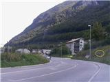
From the highway Ljubljana - Jesenice, we take the Lipce exit, where we turn right and drive to Jesenice. In the center of the town, we follow the signposts for Podmežakla. When we drive through the underpass, we turn left and continue driving on the main road for another few hundred meters, after which we notice by the road the sign with the inscription "Muzejsko območje Stara Sava". Immediately thereafter follows an intersection, where we turn right towards the residential block (left is the bridge over the Sava). Here we park in a suitable spot.
Route description:
From the parking lot, we look straight towards Mežakla, and notice a smaller footpath that ascends only a few meters in the same direction. We step onto it and ascend to a plain, where there is macadam or cart track. Here we continue left, and the path quickly brings us below the lower highway viaduct. On the other side of the highway, we can now on the left notice a more or less overgrown route (clearing) of the former electric power line, which ascends towards the top of Mežakla.
About 30 meters higher, we join it and thus begin to ascend an increasingly steep slope. There is no path here, so we can only imaginatively envision it among rocks, stones, and bushes.
The route or our path at least once crosses a poorer cart track and continues steeply ascending all the way. After approximately 30 minutes of walking, the steepness eases for a short time, but soon the terrain steeply rises again. When we get the feeling that the steepness is easing for the second time, we are near a difficult and very steep scree.
Some strenuous walking or searching for suitable passages over stones and debris, among rocks and rare bushes awaits us, until we find ourselves below the cliffs, the tops of which we can observe with the television transmitter.
The terrain becomes increasingly steep, and we gradually turn somewhat left into the forest, where we encounter stair-like landslide barriers or terrain slide retainers, under which a new cable is laid. Here we can assist ourselves by gripping steel rods. When we have already ascended right below Škrbina (50 m), we can notice that the terrain in intervals (every 2 m) between the so-called "stairs" is reinforced with concrete mass. However, caution! The concrete base is not suitable for walking, as its surface crumbles (slips). Due to the increasingly severe steepness and lack of grip, and too large a gap between the stairs, approximately 25 m before the summit we head left onto a very steep slope covered with grass and rare bushes, up which we carefully clamber to the top of Škrbina (the part of the old steel cable offered here does not provide reliable grip).
At the top of Škrbina, we head right onto the marked path, which after a short time brings us to the TV transmitter, where there is a viewpoint or our goal.
Descent recommended via the usual path over Zakop.

Photos:
 1
1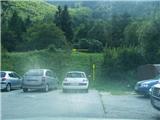 2
2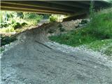 3
3 4
4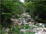 5
5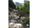 6
6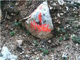 7
7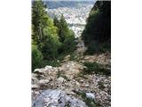 8
8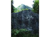 9
9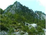 10
10 11
11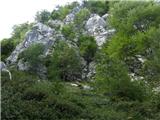 12
12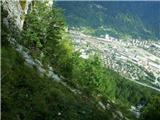 13
13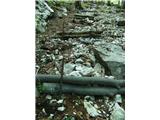 14
14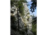 15
15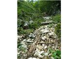 16
16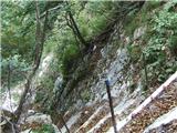 17
17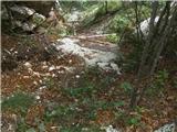 18
18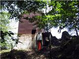 19
19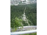 20
20
Discussion about the trip Podmežakla (Jesenice) - Škrbina (Mežakla) (along the power line)
|
| heinz11. 09. 2009 |
The route is not suitable for the inexperienced. Just below the summit, you face extremely steep terrain without reliable grip. In wet conditions, it's best not to attempt it at all.
It is possible to complete it in 1:40 hours, but I admit that due to numerous issues in the upper section (searching for passages), I took almost 2 hours.
I descended via Zakop.
|
|
|
|
| heinz11. 09. 2009 |
It's pathless terrain. As I described, most of the time you're searching for passages between rocks, scree, and sparse bushes. Towards the summit, the direction (not a path) becomes so steep that even in the best case, it won't go with "running". Much more like climbing.
Running would work on the marked path "via Zakop". You could do it in under half an hour.
Best regards, Heinz!!
|
|
|
|
| Parkeljc13. 06. 2010 |
Well, today I decided for the mentioned direction (I don't know another suitable term). Up I was exactly in 1 hour, down 40 min. I have to admit that the last 15 min is a good endurance test (mildly put). I haven't been so sweaty on uphill walking for a long long time. Actually, I want to say that I advise against the ascent if you're not really fit, as the descent would be very difficult since there is practically NO path, initially I wanted to descend the same way, but some thunder and heavy drops deterred me from the plan, so I descended via the path over Zakop. Better safe than sorry. LP
|
|
|
|
| heinz13. 06. 2010 |
Congratulations! I think 1 hour for this ascent is very fast.
At least towards the top I wouldn't recommend rushing, as it can become dangerous.
For descent I will always choose the path over Zakop.
Parkeljc, did you climb to the top on the concrete base or on the grass on the left?
Lp heinz!
|
|
|
|
| Parkeljc14. 06. 2010 |
I missed the very (lower) poles because I stuck to the rock on the right, above the transmitter, then I directed myself towards the "rough" concrete upper poles on the left, if I can call them that at all. Precisely that last one is the most dangerous, because I was looking for a grip and pushed upwards when the slab holding the concrete base gave way, but luckily I grabbed the iron support rod driven into the ground with the other hand...
Heinz, otherwise time doesn't mean anything to me, just good to know approximately for planning and other obligations. I think I could do it even faster.
LP !
|
|
|
|
| heinz14. 06. 2010 |
Yes of course, the shorter the time the more important mainly for mountain running feats, meanwhile hikers spend a lot of it enjoying the natural surroundings, breaks, photography etc., most often at a moderate-medium walking pace.
With grips in the upper part there are really problems, well, that's why I decided to go left onto the grass (the description is in that sense too), but it's not said that it means a better passage, since the terrain is almost vertical.
At this spot (by the rock) there used to be a fixed rope apparently, today it would probably come in very handy if you have a meter of rope with you..
Have you been maybe to the rock above the road on May 1st, on which the symbol - sickle and hammer is painted?
|
|
|
|
| Ljubo K.29. 12. 2013 |
With my partner we used the October temperatures at the end of December for a jump to the transmitter. First we missed and went left and then up the path towards Žakljev bivouac. After ca. 100 m of steepness we then crossed right into the gully on the track. There is actually no path. With a bit of gymnastics we went through the concrete steps. I don't recommend the path downhill.
|
|
|
|
| Jusk25. 10. 2019 |
Today after about a year I walked this nice steep path again. Not exactly as described, to the scree under the summit you can reach via a steep rocky chute, the power line trail is already too overgrown. Then straight up through the forest next to the scree on those "steps" which most are no longer there (years do their work), but at least the iron bars for grip are still there. Also climbed the concrete steps just below the summit (slippery!). View super again, clear sunny weather, descent via Zakop
|
|
|
|
| Jusk25. 11. 2020 |
today after one year I tackled this path again, need to be very careful because under the leaves it's full of stones and slippery, also in general the path is worse than last year, wooden 'steps' are collapsing, some are no longer there, iron bars for grip assistance are mostly already quite loose. At the top I catch the last today's sun rays, descended the normal path
|
|
|
|
| Majdag25. 11. 2020 |
Jusk, once years ago I went on this path to the škrbina. And I have quite enough of it, for all times..
|
|
|
|
| heinz25. 11. 2020 |
It's not a path, but merely a direction (as noted in the above comments). Decades ago when it was still a path, this part under the summit was equipped with real steps and a steel cable. Nothing left of it but the direction or some traces of the old path. It would be excellent to renovate it, but I doubt it, as PDs are no longer what they used to be. I also descended this variant, but it's not the nicest..
|
|
|
To post a comment you must log in:
If you do not yet have a username, you must first
register.