Planina Zapleč - Krnčica (from Planina Zaprikraj over Vršič)
Starting point: Planina Zapleč (1201 m)
| Latitude/Longitude: | 46,2833°N 13,6308°E |
| |
Route name: from Planina Zaprikraj over Vršič
Walking time: 4 h
Difficulty: partly demanding unmarked way
Elevation gain: 941 m
Elevation difference along the route: 941 m
Map: Triglavski narodni park 1:50000
Recommended equipment (summer):
Recommended equipment (winter): ice axe, crampons
Views: 13.048
 | 3 people like this post |
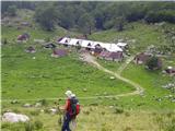
Access to starting point:
From Drežnica above Kobarid along an asphalt road to Drežniške Ravne, then along a sometimes slightly worn-out macadam forest road to the parking lot in front of the mountain pasture Zapleč.
Route description:
From the parking lot, we continue on the road over mountain pasture Zapleč to the neighbouring mountain pasture Zaprikraj. On the right, we look for a footpath that leads to the ridge. On the ridge, we follow a beaten path among remains of Italian military positions from the Isonzo Front, past peaks Vršič, Vrh Ruš, Oblo Brdo to the wide saddle Vrata, from where along a wide pathless ridge we reach the peak of Krnčica.
Photos:
 1
1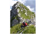 2
2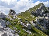 3
3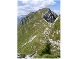 4
4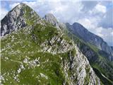 5
5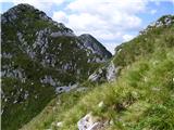 6
6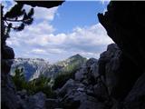 7
7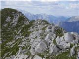 8
8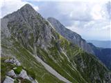 9
9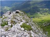 10
10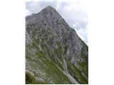 11
11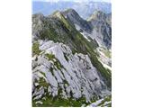 12
12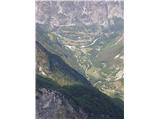 13
13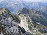 14
14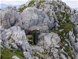 15
15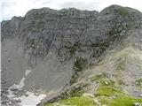 16
16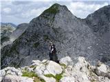 17
17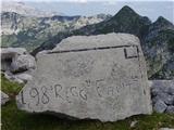 18
18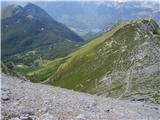 19
19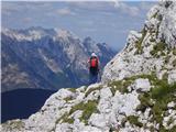 20
20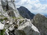 21
21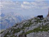 22
22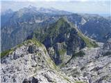 23
23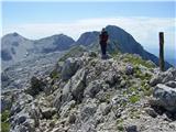 24
24
Discussion about the trip Planina Zapleč - Krnčica (from Planina Zaprikraj over Vršič)
|
| ajo6231. 10. 2014 |
Yes, likewise, Masker. The day was wonderfully autumnal, ideal temperature, unique views all the way to the Dolomites-with the naked eye from the top of Krnčica you could see Pelmo, Civetta, Antelao.. not to mention the neighboring Julijci. Above 1900m there was some snow or ice on some shady spots. Otherwise I started the tour from Planina Zapleč towards Vrata and Krnčica, back along the ridge mulatjera to Vršič and down the other mulatjera to Planina Zaprikraj. There I also met the only person on this tour, the nice hiker Maja, who like me was enjoying the last afternoon rays of autumn sun while walking..
|
|
|
|
| masker1. 11. 2014 |
Oh wow! You've nicely described and shared your impressions and feelings from your autumn mountain tour. I believe you enjoyed it 100%, as Friday was perfect for such mountaineering feats.....and you made good use of them. You were also lucky to enjoy them in pleasant female company!! Have a good time and enjoy this first November day, which is also sunny. Take care!:
|
|
|
|
| CarpeDiem2471. 11. 2014 |
Great photos, hope I go on this trail myself soon.
|
|
|
|
| vstarc1610. 11. 2015 |
Last weekend I hiked the ridge from the Vršič saddle to Krn. The road from Drežniške ravne (3.5 km gravel) to pl. Zapleč is mostly fine, there are some rough spots, but normally drivable with a passenger car. From planina Zapleč I hiked the first 350 m of elevation off-trail (grass) towards the Vršič saddle until I caught the mule track. Further to the ridge and along it the walking was comfortable, at the Vrata pass the marked path from pl. Zapleč joins. The path across the Krnčica ridge is marked and leads all the way below Krnska skrbina. Since I was walking in the dark from Srednji vrh onwards, the markers quite facilitated orientation, only at a few spots did I stray a bit from it. I slept in ZS Gomiščkovega zavetišča with a wonderful night view of the hinterland of the Tržaški zaliv. On Sunday there was another nice autumn day with views all the way to the Dolomite peaks. I descended via the Silva Korene path and then the Zahodni drežniški route. The trail leading back to pl. Zapleč is somewhat incorrectly drawn on my map (KRN, PZS, 1992), best to look for it right below the rocks and it is only indicated in the first part, later it disappears several times and has to be searched for.
|
|
|
|
| skiro12318. 08. 2019 |
Today I was on this path and I strongly advise against it. The mule track leading to the ridge is completely overgrown, much the same is the path/mule track along the ridge from Kala (?) all the way to Vršič. Only from there onwards (where it joins the marked path) is the path such that it can bear this name. Since the path has little information (description, photos) it would be better if it weren't among the paths. Of course this doesn't diminish Krnčica as an excellent destination. Nice and panoramic summit!
|
|
|
|
| winni7. 06. 2020 |
I agree with the previous one, the path to the saddle between Vršič and Kal is completely overgrown, you have to search for the path among clumps of tall grass, which makes the ascent very strenuous.
The descent is certainly easier.
|
|
|
|
| akvarij19. 09. 2020 |
Today we descended this path and the descent is neither easy nor pleasant. Luckily, we had a beautiful tour to Krnčica and Lopatnik behind us and we didn't get too upset 
|
|
|
To post a comment you must log in:
If you do not yet have a username, you must first
register.