Planina Zajzera - Jôf di Montasio/Montaž (Via Amalia)
Starting point: Planina Zajzera (1004 m)
| Latitude/Longitude: | 46,4565°N 13,46924°E |
| |
Route name: Via Amalia
Walking time: 6 h 45 min
Difficulty: very difficult marked way
Via ferrata: C
Elevation gain: 1749 m
Elevation difference along the route: 1900 m
Map: Julijske Alpe - zahodni del 1:50.000
Recommended equipment (summer): helmet, self belay set
Recommended equipment (winter): helmet, self belay set, ice axe, crampons
Views: 64.786
 | 5 people like this post |
Access to starting point:
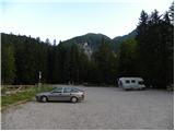
From Kranjska Gora, via the border crossing at Rateče, we drive to Trbiž / Tarvisio. Further on, we drive on the old road towards Videm / Udine. Already after a few kilometers from Trbiž / Tarvisio, the road into Ovčja vas / Valbruna branches off to the left. Here we turn left and follow the road all the way to the mountain pasture Zajzera, where we park on a large parking lot.
Route description:
From the parking lot, we head onto the road closed to traffic following the signs for Bivacco Mazzeni, Bivacco Stuparich. The road first slightly descends and then leads us through the forest. Soon we come out of the forest to a wide stream bed, where a huge amount of sand is deposited. Here the path is somewhat less visible, and we cross the sandy terrain slightly to the right. The path then brings us to a junction, where we go right following the signs Bivacco Stuparich. With the help of some cairns we again cross the torrent to the right, and then the path brings us into the forest. The path through the forest soon starts to ascend quite steeply, then turns to the left, and soon nice views open up to the walls of Montaž. The path further leads along the stream bed past some bushes and dwarf pines and brings us to a junction. We continue to the left following the signs Stuparich, and to the right the path leads towards the mountain hut Grego.
Here the path turns to the left and starts ascending in zigzags through sparse forest on the left side of the valley. Such a path brings us again to a junction. We go left towards bivouac Stuparich, while to the right the path leads towards Dunjska dolina. Further on, the path starts crossing the slope towards the east and soon brings us to bivouac Stuparich.
From the bivouac, we return a few meters back, where an inscription on a large rock directs us right upwards (southwest). The path left downwards (southeast) leads towards bivouac Mazzeni.
For a short time we then ascend on a somewhat overgrown path through bushes, then the path brings us to the bed of a torrent. Here we turn left and ascend along the right side of the torrent bed upwards. Trail markers are scarce here, but numerous cairns help us. The path then turns right and crosses the slopes below Montaž towards the west all the way to the start of the climbing section.
The climbing path at first turns left into the wall and starts ascending in steep zigzags along the steel cable, aided also by some pegs. At some points the path rises almost vertically. The path then turns right and ascends very steeply along the steel cable upwards. This is followed by a vertical ascent aided by numerous brackets, which brings us to a narrow notch. Through the notch we slightly descend, then follows a demanding vertical ascent left upwards. In addition to the steel cable, some pegs also assist the ascent.
Further on the path becomes somewhat less demanding and starts ascending along the steel cable up a fairly wide gully. The path then turns left and for a short time brings us onto a level grassy slope, after which it resumes ascending up the rocky slope. Further on, the path ascends quite steeply several more times along the steel cable, aided by some brackets. The path then brings us below Severni stolp (Torre Nord), where it turns right. Here we cross steep slopes towards the west; in early summer there are often snow patches here. This is followed by ascent up steep grassy slopes and then ascent along the steel cable up a slightly crumbly slope. Such a path then brings us to a narrow ridge from where beautiful views also open towards the west. A short ascent along the ridge follows, then the path turns to the west side and starts descending a steep grassy slope. Further on, the path crosses slopes towards the south for some time, then turns left and ascends somewhat more steeply up the rocky slope. To bivouac Suringar only a short traverse along the ledge to the right remains.
From the bivouac we continue south and cross the western slopes for a short time more, then reach a junction where the markers direct us left upwards. The path, marked with red dots, starts ascending quite steeply and brings us into the Findenegg couloir. The ascent through the couloir is relatively steep and exposed to falling rocks. The path on this section is unsecured, and most of it is first-degree climbing, with a short section also second-degree.
At the exit from the couloir the path becomes somewhat crumbly, so we must be careful not to dislodge rocks. Further on, the path brings us to an exposed ridge along which we soon reach the panoramic summit.
Descent is possible via the ascent route. However, since this is a long and extremely demanding path, it is recommended to arrange transport from mountain pasture Pecol and descend via the usual south path over Pipan's ladder.

Photos:
 1
1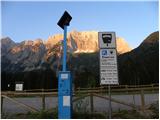 2
2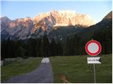 3
3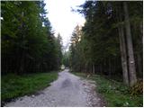 4
4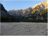 5
5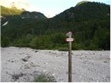 6
6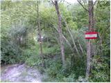 7
7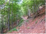 8
8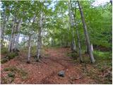 9
9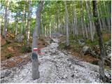 10
10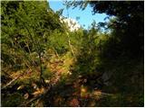 11
11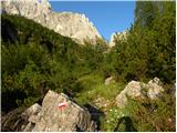 12
12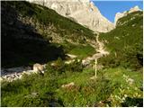 13
13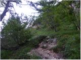 14
14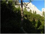 15
15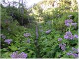 16
16 17
17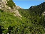 18
18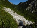 19
19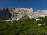 20
20 21
21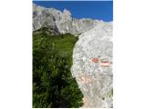 22
22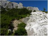 23
23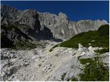 24
24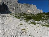 25
25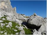 26
26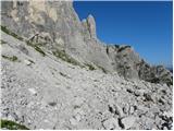 27
27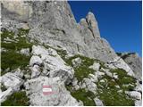 28
28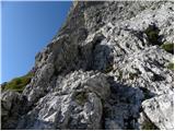 29
29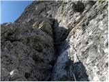 30
30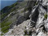 31
31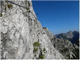 32
32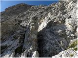 33
33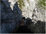 34
34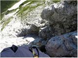 35
35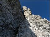 36
36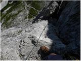 37
37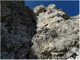 38
38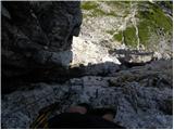 39
39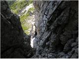 40
40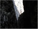 41
41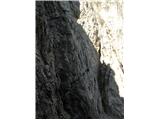 42
42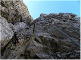 43
43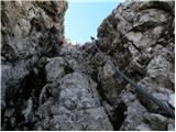 44
44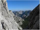 45
45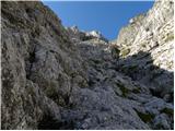 46
46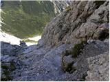 47
47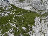 48
48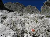 49
49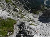 50
50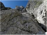 51
51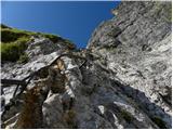 52
52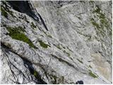 53
53 54
54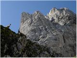 55
55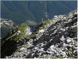 56
56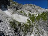 57
57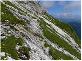 58
58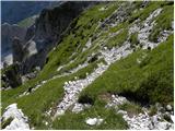 59
59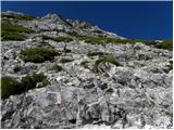 60
60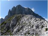 61
61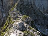 62
62 63
63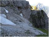 64
64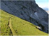 65
65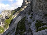 66
66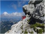 67
67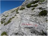 68
68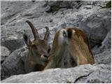 69
69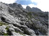 70
70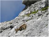 71
71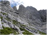 72
72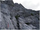 73
73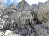 74
74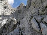 75
75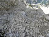 76
76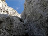 77
77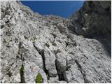 78
78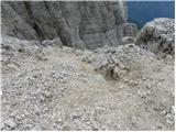 79
79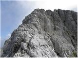 80
80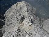 81
81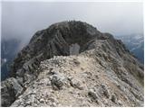 82
82 83
83
Discussion about the trip Planina Zajzera - Jôf di Montasio/Montaž (Via Amalia)
Show older messages
|
| BT8813. 08. 2009 |
Has anyone gone on this path recently? Because 6:45h is really a lot for Montaž.
|
|
|
|
| ania13. 08. 2009 |
I'm also curious..... 
Best, A.
|
|
|
|
| Rok13. 08. 2009 |
I went on this route last week and it took me about 5 hours.
If we consider that an average hiker takes about 1 hour for 300 meters, in my opinion 6h 45min is quite realistic.
Additionally, we descend a bit in some places, and more time is needed due to self-belaying.
At the start, the signs only give the time to bivak Stuparich (1587m), namely 2h.
|
|
|
|
| Zenfinio28. 09. 2009 |
In short, it's obligatory to take an ice axe and crampons if you go via Amalia because just before the entrance to the climbing part of the path there is a large snowfield and it's also very steep. I myself got turned away on Saturday because I trusted the story on this forum that didn't mention the snowfield .... so winter gear is definitely in place (verified).... as for the times, if you accidentally see the mark on the rock near bivouac Stuparich which is almost behind the rock and very poorly visible (last painted in 82)  I'd say they hold up to the climbing part quite well.... typically Italian markings (sloppy) I'd say they hold up to the climbing part quite well.... typically Italian markings (sloppy)
|
|
|
|
| Zenfinio28. 09. 2009 |
P.S. admins: put ice axe and crampons under recommended summer gear here :
|
|
|
|
| Rok28. 09. 2009 |
Is that snowfield "before the entrance to the climbing part of the path" near bivouac Suringar?
|
|
|
|
| triglavski28. 09. 2009 |
Zenfinio obviously missed the entrance to Via Amalia a bit, that snowfield is namely on the Direta Kugy path, which has nothing to do with Amalia. I always say that one needs to prepare properly for the tour and the marks are not that bad at all, you can get nicely from bivouac Stuparič to the entrance of Amalia.
|
|
|
|
| ben28. 09. 2009 |
I completely agree with Triglavski, from bivouac Stuparič to the entrance to Amalia there is no trace of any snowfield, unless you miss the entrance BIG TIME. It's true that from the bivouac to the entrance to Amalia there isn't exactly paint marks every five meters, but there are quite enough cairns so that ....
Regards B
|
|
|
|
| Zenfinio28. 09. 2009 |
hmmm Triglavski I allow the possibility of my mistake so I'll check again on Saturday when I hope there'll be more sun than last Saturday.... but the markings are still bad but we won't wait here as it's not necessary thanks for the info Triglavski.... Lp
|
|
|
|
| Zenfinio28. 09. 2009 |
hmm triglavski one more thing interests me since I see you know this path well.... where did I go wrong then i.e. I went up the gully and then turned towards the wall left following the markings the only ones I found really but it was very foggy and visibility was about 20m ????? please help so I don't go there in vain again.... Lp
|
|
|
|
| ben28. 09. 2009 |
If you allow, I'll try to help. Somewhere in the middle of the gully the path to Amalia turns decisively to the RIGHT and then you traverse for quite some time to the entrance. It's true that in fog it can be confusing there if you don't know the path. Anyway before the snow that you saw, decisively to the right. Then look for the cables and there won't be problems
lp B
|
|
|
|
| Zenfinio28. 09. 2009 |
uu super thanks for the info I'll check..... Ben have you already done Amalia???? what did you think of it?????
|
|
|
|
| ben28. 09. 2009 |
I was there about a month ago. Seemed? well what do I know, the lower part fantastically secured, higher up a bit torn cables, but no particular panic. A bit steep grass, all in all fine. But quite long.
lp B
|
|
|
|
| Zenfinio28. 09. 2009 |
and did you descend the same path back (how much time did it take you) but since I was planning to descend the same path I started walking towards Amalia at 6am.... unfortunately standstill but smart decision given the situation....
|
|
|
|
| ben28. 09. 2009 |
No, descent via Pipanova on via normale to Pecol, because of logistics, we were two and thus two cars. The whole tour took less than 10 hours (ascent and descent)
lp B
|
|
|
|
| Zenfinio28. 09. 2009 |
no no that interested me because we two were also two but went with one car so we'd have to be quite fast to do Amalia in one day.... so I'll do something similar... cool thanks again for the info... I'll let you know how it goes......
Lp Z
|
|
|
|
| triglavski28. 09. 2009 |
For such a beautiful path I really recommend good weather too, because only then does all the majesty of Montaž come into play. The rest Ben answered, so under the glacier moraine to the right, on some rocks it even says Via Amalia I was always in the sun so no problems, of course the markings could be renewed, but everywhere such workers are lacking, so... recommend in dry conditions because under the shoulder it can be quite slippery, definitely one car at Pecol and if there's still time enough no need to descend immediately but can turn left under the snowfield to A.E Leva up to under Špik Hude police. Satisfaction would be complete.
|
|
|
|
| domoljub29. 09. 2009 |
Hello!
Can anyone share the technique for taking photos on such very demanding paths. With a via ferrata set you're already secured but it's a bit scary when you're handling the camera and only two ropes prevent the fall. Is it just improvisation here or are there attachments for the helmet or something similar available.
Sometimes you see such a nice frame to shoot but you can't because you're just in the "iron" at that moment. Joke aside. Sincere thanks for any suggestions.
Best regards.
|
|
|
|
| bridnk29. 09. 2009 |
Yeah, where will you fall if you have two prusiks  Better get a camera and film the whole path . Better get a camera and film the whole path .
If you don't feel stable enough or if the wind gusts are too strong, leave the camera alone .
|
|
|
|
| peterr29. 09. 2009 |
I use a climbing kit (two carabiners and a short sling), I clip in at the first fixed piton and thus have both hands free for photography. Recently I took hundreds of photos with two cameras in a D-E rated via ferrata (Falsbach klettersteig) without any problems. On more demanding via ferratas this kit is also useful for resting. The self-belay kit is for protection, but for photography it's recommended to be secured more shortly.
Peter
|
|
|
|
| peterr29. 09. 2009 |
To avoid misunderstandings, (the kit is only for fixing, clipped into the climbing harness and onto the cable) self-belay must also be in place on the cable then. You can view the photos at:
http://sl.netlog.com/5r54/photo/setid=217948
|
|
|
|
| bridnk30. 09. 2009 |
nice photos, I'm interested in the time for this via ferrata, as it looks quite short?
|
|
|
|
| peterr30. 09. 2009 |
In the guidebook on Austrian climbing routes, the height is listed as 240m and time 2 hours, with approach and descent 3 hours, and that holds true for our group.
|
|
|
|
| tilenko26. 10. 2009 |
Yesterday I took this path to the summit and must warn that from the via ferrata onwards it's quite snowy and icy, in places snow sinks to the waist, so I recommend ice axe and crampons.
|
|
|
|
| bostjann9. 07. 2010 |
Interesting, does anyone have any information about the condition of Via Amalia: snowfields, fixed protections...?
|
|
|
|
| IgorZlodej9. 07. 2010 |
There might still be quite a bit of snow there, in the central gully, and higher up too where the path crosses under the natural bivouac on the grass under Ramo, and of course on the other side of Ramo after bivouac Surnigar, also on Velika polica there's probably still some snowfield, but these are just predictions that can be quickly handled with proper gear.
|
|
|
|
| bostjann9. 07. 2010 |
Igor, thanks for the reply, I'll probably tackle it in the coming days.
cheers!
|
|
|
|
| skrajnik19. 07. 2010 |
What are the conditions like?
Can one reach Amalia solo with 2 ice axes, without crampons?
|
|
|
|
| skrajnik21. 07. 2010 |
Is there by any chance a possibility of descent to the starting point (other than by the same path)?
|
|
|
|
| BT8821. 07. 2010 |
I think not or nothing easy to the valley. Mihelič wrote that he returned down Via Amalia to the valley alone saying it's more like riding a cable car on prusik!
|
|
|
|
| skrajnik21. 07. 2010 |
thanks..
but we'll need 2 cars..
we're leaving now
|
|
|
|
| BT8822. 07. 2010 |
You'll tell us how it was. GOOD LUCK
|
|
|
|
| stuchlyan24. 08. 2010 |
On Saturday we did the tour Via Amalia-Findeneggov ozebnik-Montaž-Pipanova lestev-Pecol. The entry wall of Amalia is very steep but well secured (self-belaying essential) so no particular problem, except it's not for those afraid of heights. Higher up, where the wall flattens, the fixed cables are sparser and supplemented at one point with now quite torn rope. That step is very demanding, but can be nicely bypassed to the left without major difficulties (traces of original pitons). We didn't use ice axes as the snow patches were no longer an obstacle.
On Velika polica there is a misleading path well trodden and visible from afar, so watch out not to be misled. When we pass the large black chasm (on the left) watch the marks that lead up and with some easy scrambling to the narrow ledge along the edge to bivouac Surnigar.
Findeneggov ozebnik is nice (steep), with good rock but quite loaded in the upper part so carefully... We descended to Pecol where transport home awaited us.
The tour was great, but didn't seem much harder to me than say Hanzova with Jubilejna in Prisank. Highly recommend to all who are up to it.
A few more pics: http://picasaweb.google.com/stuchlyan/Montaz_Amalia#
LP Andrej
|
|
|
|
| fonzi29. 08. 2010 |
Has anyone already done Zajzera - Montaz - Spik nad Cjanarco - Spik Hude police - Spik nad Spranjo - past Prednja Spranja to bivak Mazzeni and back to the Zajzeri parking lot. How much time would that take and where to overnight in between? Best regards, Fronc
|
|
|
|
| Bojan_A30. 08. 2010 |
Wow, that's a good tour. And no transport issues.
|
|
|
|
| fonzi30. 08. 2010 |
Thanks, Gorazd, I'll report the conditions on the way back. Fonza
|
|
|
|
| BT8831. 08. 2010 |
Could you explain this path to me a bit because I'm not quite clear how this thing goes. Thanks
|
|
|
|
| Rok31. 08. 2010 |
Here the path is marked with a thickened red line.
|
|
|
|
| BT8831. 08. 2010 |
Super, thanks Rok, it can be done in one day if you're really fast maybe but then you see less hm
|
|
|
|
| igorf31. 08. 2010 |
Actually, this is a "combination" of three routes: Via Amalia, then the Leva route, and then the Ceria-Merlone route. All three routes are well described in the Western Julian Alps guidebook. The entire route is really very beautiful (and of course demanding). In one day it might just be too much (unless you're some kind of runner). I would recommend that at the end of Ceria-Merlone (I forgot the name of the notch..., where the Anita Goitan route starts climbing) you descend to Rifugio Corsi and the next morning back over the notch to the starting point.
|
|
|
|
| tilenko26. 06. 2011 |
Yesterday my friend and I completed this path or rather the ascent. We approached and descended from Zajzera via Amalia and then through Findenegg glacier. There are still quite a few very steep snowfields on the path, so without crampons and ice axe don't go up.
|
|
|
|
| wasabi27. 07. 2011 |
How demanding is the route from the summit of Montaž to Zajzera that Rok marked with a red line? Does it also have many steep snow patches and dangerous sections there?
|
|
|
|
| tinotej17. 08. 2012 |
Hello... I'm interested in whether anyone was on Montaž via Amalia path... I'm interested in the conditions and if the protections were ok.. also how it is regarding the snowfield... nice greeting and thanks for answers..
|
|
|
|
| moro7. 08. 2012 |
Went on 3.8. to Montaž / Jôf di Montasio via Via Amalia. The path was nicely passable without any snow patches, so no need to carry crampons and ice axe. Protections are fine. The cable is new, looks like it was recently replaced. Quite demanding, but really super tour..recommend.
LP
|
|
|
|
| NEIC00820. 08. 2012 |
..And why is this path ''extremely demanding''?? Because of the length??
|
|
|
|
| velkavrh20. 08. 2012 |
Why extremely demanding? Already because of the length, which is about seven hours in one direction and no hut in between. If you don't have arranged transport from Planina Pekol, because from Montaž you can descend to Planina Pekol but then have to return the same way back. You can calculate that it's a full-day tour. As far as I know, there are already several demanding secured sections up to bivouac Suringar. The cables go quite steeply uphill, and on this path you have to go back down too, if there's no other way. I only know the path over the glacier to Montaž and down via Pipanova lestev. The ascent over the glacier alone is a solid challenge, which I don't recommend to those inexperienced in free climbing UIAA I and II. Over some jumps it's quite demanding to get through. True, the path over the glacier takes only one hour. The descent down Pipanova lestev is another problem. I recommend a climbing harness, if nothing else because of the constantly falling rocks. From my experience - I was there once last year, twice this year - more hikers trigger them than ibex, of which there are plenty there. Only if you scare them and they bolt would they also trigger rocks. Hiking there mandatory requires a helmet. This end around Špiki attracts me extremely and I will do this described path here, just without the ascent to Montaž, because I've had enough of it this year.
I wish you much enjoyment on the tour and lots of liquid with you!
|
|
|
|
| NEIC00820. 08. 2012 |
Thanks for the info. I asked because secured paths are no problem for me, from the description it seems the path is quite well secured except for the glacier. I've already done the path via Pipanova lestev. Of course, transport from Planina Pekol is necessary.
LP
|
|
|
|
| dprapr20. 08. 2012 |
In my opinion, it is demanding mainly because of the length and elevation gain, technically at the beginning and end in the glacier.
There is no UIAA II in the glacier!
|
|
|
|
| velkavrh20. 08. 2012 |
I'm not an alpinist to give difficulty ratings over the glacier, but even in the presentation of the path over the glacier it's mentioned that it also involves grade II. There were a couple of really demanding jumps. They weren't too hard for me, but probably for many they are.
|
|
|
|
| poloneza113. 09. 2020 |
Today three of us trained ones did Amalia. To the top of Montaž it took us 6 hours. Amalia is very well equipped, but currently there's a problem on the steep western grassy slopes, where 2 pegs are pulled out (from the ground) and there's no cable there. Currently the situation is quite serious, as a slip there means a flight into Dunja. Rope and grigri are very welcome....
|
|
|
|
| NecroRedbull22. 07. 2021 14:37:25 |
Has anyone done this route in the last few days? What's the snow situation like?
|
|
|
|
| mikkeni27. 10. 2022 08:00:26 |
Has anyone done this route this week maybe? Snow and such?
|
|
|
|
| malimiha27. 10. 2022 09:38:25 |
Officially the path is closed lp
|
|
|
|
| natasacraine30. 06. 2023 16:03:02 |
And does anyone know, is the path already open?
|
|
|
|
| Zala120819. 08. 2023 15:53:06 |
Via Amalia is passable, but the intermediate difficult sections are not secured except for one fixed rope, which the hiker can hold for additional stability. Not for inexperienced climbers and vertigo sufferers.
|
|
|
To post a comment you must log in:
If you do not yet have a username, you must first
register.