Planina Zajzera - Jof di Miezegnot/Poldašnja špica
Starting point: Planina Zajzera (1004 m)
| Latitude/Longitude: | 46,4565°N 13,46924°E |
| |
Walking time: 3 h
Difficulty: very difficult marked way
Elevation gain: 1083 m
Elevation difference along the route: 1100 m
Map: Julijske Alpe - zahodni del 1:50.000
Recommended equipment (summer): helmet, self belay set
Recommended equipment (winter): helmet, self belay set, ice axe, crampons
Views: 32.772
 | 4 people like this post |
Access to starting point:
From Kranjska Gora over the border crossing Rateče we drive to Trbiž / Tarvisio. Further, we drive on the old road towards Videm / Udine. Already after a few kilometers from Trbiž / Tarvisio, the road into Ovčja vas / Valbruna branches off to the left. Here we turn left and we follow the road all the way to the mountain pasture Zajzera, where we park on a large parking lot.
Route description:
From the parking lot from where there is a very nice view towards the northern wall of Montaž we head to path 611 on the right side of the chapel. We follow the signs for mountain hut Rifugio Grego and already at the beginning we start relatively steeply ascending through the forest, and later we also cross a macadam road a few times, which also leads towards the mountain hut Rifugio Grego. After that, the path turns slightly to the right and brings us to a forested ridge from which some views also open on the northern side. For a better view, it is necessary to step onto one of the panoramic points on the edge of the ridge, whereby some caution is needed since the ridge is precipitous on the northern side.
Further on, we continue ascending through the forest and occasionally beautiful views open towards Montaž and Viš. We follow such a path all the way to the mountain hut Rifugio Grego where there is a wonderful view mainly towards Montaž.
From the mountain hut, we descend a little on a macadam road to the saddle Rudni vrh (Sella di Somdogna) to which an asphalt road from Dunjske doline also leads. Here we turn right onto a macadam road which in a short ascent brings us to the hut Somdogna.
At the hut the markings direct us through a meadow into the forest through which we then ascend. The path soon turns slightly to the right and starts to ascend quite steeply in zigzags. The steepness does not let up until we come out of the forest onto the alpine pasture from which the summit of Poldašnja špica is already visible.
Soon from the left the path from Pipar joins and to the bivouac Gemona only a short ascent on a grassy slope follows.
At the bivouac we continue towards the north and follow the signs for path 609. After a short ascent the path brings us to a less distinct southwestern ridge where to the right an unmarked transverse path branches off, which leads towards the southeastern slope of the mountain along which a slightly easier path to the summit leads.
We continue straight along the ridge, higher up the path turns slightly to the right and brings us to a crumbly slope. Here the path becomes significantly more demanding and is mostly secured with a steel cable. Due to the crumbliness considerable caution is required.
The secured section soon ends and is followed by an ascent along the scenic summit part of the mountain to the panoramic summit.
The description and pictures from the bivouac Gemona to the summit refer to the condition in September 2023. Other pictures are older.

Photos:
 1
1 2
2 3
3 4
4 5
5 6
6 7
7 8
8 9
9 10
10 11
11 12
12 13
13 14
14 15
15 16
16 17
17 18
18 19
19 20
20 21
21 22
22 23
23 24
24 25
25 26
26 27
27 28
28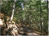 29
29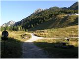 30
30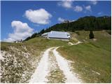 31
31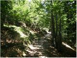 32
32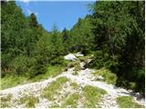 33
33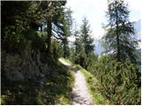 34
34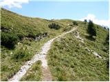 35
35 36
36 37
37 38
38 39
39 40
40 41
41 42
42 43
43 44
44 45
45 46
46 47
47 48
48 49
49 50
50 51
51 52
52 53
53 54
54 55
55 56
56 57
57 58
58 59
59 60
60 61
61 62
62 63
63
Discussion about the trip Planina Zajzera - Jof di Miezegnot/Poldašnja špica
|
| Gost8. 10. 2007 |
If we write mountain names and some places bilingually, it's right to write the place name Udine also in the Slovenian form: VIDEM.
|
|
|
|
| jani bele13. 08. 2013 |
In the gully just below the summit things get complicated. You can see the path continuation on the other side, but the crossing is so worn that it's better to follow tracks and marks straight up the gully, where it's crumbly and requires extra caution on descent. This section doesn't deserve an "easy" rating.
|
|
|
|
| damijanp13. 08. 2013 |
I agree. We found that out yesterday too and turned back at that point.
|
|
|
|
| Paglia10. 12. 2013 |
Brane
7.12.2013
Since I had already been twice in winter to this beautiful panoramic summit, we chose it again this time. Up to koča Grego it was a bit icy below, higher without problems, the hut even surprisingly open.
Further on also trodden, little or no drifting snow. At bivouac Gemona short break, then further following previous tracks to some pre-summit. Then ... darkness. No further tracks, although it was just a slight descent and then about 50 m to the top. Everyone unanimously decided it was too dangerous due to risk of slipping and we followed reason rather than the summit and TURNED BACK.
Otherwise fantastic weather, no wind, fantastic views, of course Montaž reigns.
Note: If conditions are better, it's not bad to have crampons and ice axe for the final ascent.
lp
|
|
|
|
| IgorZlodej10. 12. 2013 |
I have been to Poldašnja špica about 20 times, 5 or 6 times I also skied down from the top, but never needed crampons, of course everything depends on the conditions, if they were good I even reached the summit on skis.
|
|
|
|
| golica23. 05. 2016 |
Next week we're going to Poldašnja špica. In the comments I saw (also otherwise the path is marked as easy, towards the top demanding, that it can get "at least for me-complicated" before the summit), asking, is it precipitous, crumbly? maybe some picture of this "section". Thanks
|
|
|
|
| VanSims24. 05. 2016 |
On the path from Bivacco Gemona to the summit, there is one rocky step that is a bit more demanding, the rest is all easy. Because of this section, I would also mark the path as partially demanding.
The gully that @jani mentions is on the path coming from Ovcja vas. You need to follow the footsteps and be a bit careful. Saying that this path is demanding as written on this portal is an exaggeration.
|
|
|
|
| IgorZlodej25. 05. 2016 |
The summit section of the path was closed last year  , and photos can't be uploaded here, you need to ask under forum-conditions , and photos can't be uploaded here, you need to ask under forum-conditions 
|
|
|
|
| golica25. 05. 2016 |
VanSims thanks for the explanation, I admit I was waiting for Mr. Zlodej's comment, because I know he's a top expert on these areas,/predictions from his comments.
I'll check under forum-conditions, maybe find something. thanks 
|
|
|
|
| lepenatka17. 07. 2016 |
Yesterday climbed this mountain with wonderful views.
The upper part is still officially closed (as Igor writes). Descent on the other side and back to the bivouac or cross. The path is eroded in places, so before the nastiest part I went down through the grass.
Traverses and paths are there, caution as everywhere necessary.
Safe on the paths
|
|
|
|
| katty21. 04. 2017 |
Hi.
Does anyone perhaps have any information on what the current conditions are like on the path described above to Poldašnja špica? Thanks
|
|
|
|
| michael6631. 05. 2017 |
On Sunday I went from Zajzera to Poldašnja špica. Nowhere does it say the path is closed. But in my opinion it should be, as it's in very bad condition below the summit. Whether there was a landslide or water caused it, I don't know. The gully is steep, crumbly and full of sand. Neither grip nor footing are 100%. If you slip, you won't stop for at least 100 meters and even then in who knows what condition. If there's someone ahead or above you, an accident is very close. One Italian dislodged a fairly large stone... about 20 kg... It missed me by a meter or two, grazed my partner on the side. Nothing serious, just a bruise, but it was by centimeters. If someone heads up anyway, carefully. Apart from the mentioned section, the path is nice and easy, views wonderful.
|
|
|
|
| jax31. 05. 2017 |
That passage was tricky already before. If it's even worse this year, I really wouldn't know.
|
|
|
|
| dprapr31. 05. 2017 |
That section is not the only possible approach to the summit.
|
|
|
|
| michael6631. 05. 2017 |
Yes, one came from Ovcja vas
|
|
|
|
| ljubitelj gora3. 10. 2017 |
Yesterday quite late from Zajzera to Poldašnja špica. Deciduous trees are already autumn-colored, larches gaining color. Below the summit the path is very demanding, crumbly and great caution is needed.
|
|
|
|
| srči24. 08. 2018 |
On Wednesday 22.8. I was on Poldašnja špica. The path below the summit, through the gully is now equipped with 3 safety devices (cable) so that one can now approach the summit more safely.
|
|
|
|
| srči24. 08. 2018 |
let me also write that this time I drove via the alpine, 18 km long road, to the saddle Rudni vrh (photo 6) and shortened the path by about 1 hour.
From Planina Zajzera I went to Due Pizzi last year.
The road is in excellent condition and well guarded and I definitely recommend it as a trip combined with a short tour
|
|
|
|
| babim25. 08. 2018 |
Folks, I'm interested if the car access to Rudni vrh was from Zajzera or Dunje?
|
|
|
|
| bbugari125. 08. 2018 |
Car to Rudni vrh is possible only from Dunje.
|
|
|
|
| Vladimir197317. 08. 2023 12:34:25 |
Hello,
I would like information on the condition of the upper part of the path to POLDAŠNJA ŠPICA from bivouac Gemona to the summit.
Thanks and best regards
|
|
|
|
| Johan6418. 08. 2023 07:35:46 |
The upper part of the path... the steepest part is a bit awkward due to crumbly rock. The section where there is the wire rope we bypass by veering right across the sandy gully and then continue upwards through partially vegetated and rocky terrain back to the path. It's already a bit trodden. The rest is no problem.
Best, Ivan
|
|
|
|
| skiro12310. 09. 2023 12:34:53 |
We did the path yesterday and I would point out a few things:
1. The time estimate (walking time) compared to other ascents is not appropriate. A more suitable approximate length is 3:00 or 3:15.
2. The difficulty is at the upper edge (partly difficult), but only due to the last section. I wouldn't change that, but I would warn that the section secured with wire rope is A/B or B difficulty if it were a via ferrata. If we bypass this section, caution is needed because it is quite slippery due to sand on the path. The choice depends on personal preferences and sense of safety.
3. If you drive to the saddle via Dunja by car, the path shortens by 1/3 or 1 hour.
Otherwise, one of the better viewpoints I've walked. I recommend it to everyone looking for views and nice, less crowded spots in the mountains. Since the path to the last section is very easy and the views are already excellent before, you won't lose much if you end the ascent a bit before the summit (and skip the difficult part).
|
|
|
To post a comment you must log in:
If you do not yet have a username, you must first
register.