Planina Zajzera - Cima Alta (Due Pizzi) (path 648)
Starting point: Planina Zajzera (1004 m)
| Latitude/Longitude: | 46,4565°N 13,46924°E |
| |
Route name: path 648
Walking time: 4 h
Difficulty: very difficult marked way
Elevation gain: 1042 m
Elevation difference along the route: 1280 m
Map: Julijske Alpe - zahodni del 1:50.000
Recommended equipment (summer): helmet, self belay set, lamp
Recommended equipment (winter): helmet, self belay set, ice axe, crampons, lamp
Views: 28.061
 | 3 people like this post |
Access to starting point:
From Kranjska Gora over the border crossing Rateče we drive to Trbiž / Tarvisio. Further, we drive on the old road towards Videm / Udine. Already after a few kilometers from Trbiž / Tarvisio, the road into Ovčja vas / Valbruna branches off to the left. Here we turn left and we follow the road all the way to the mountain pasture Zajzera, where we park on a large parking lot.
Route description:
From the parking lot from where there is a very nice view towards the northern wall of Montaž we go on the path 611 on the right side of the chapel. We follow the signs for mountain hut Rifugio Grego and already at the beginning we start relatively steeply ascending through the forest, and later we also cross a macadam road a few times, which also leads towards the mountain hut Rifugio Grego. After that, the path turns slightly to the right and it brings us to a forested ridge from which some views also open up on the northern side. For a better view, we need to step onto some of the panoramic points on the edge of the ridge, and in doing so some caution is needed because the ridge is precipitous on the northern side.
Further, we continue ascending through the forest and occasionally beautiful views open up towards Montaž and Viš. We then follow such a path all the way to the mountain hut Rifugio Grego where there is a wonderful view mainly towards Montaž.
From the mountain hut, we descend a little on a macadam road to the saddle Rudni vrh (Sella di Somdogna) to which an asphalt road from Dunjska dolina also leads. We continue on the asphalt road, on which we descend a few turns, and then we leave the road and go right on a narrow marked footpath.
The path then mostly steeply ascends through dwarf pines and crosses a few torrents. We follow such a path all the way to a marked junction where the path to Pipar (2069m) branches off to the right.
We continue left on path 468 toward bivouac Bernardinis. From the junction, the path slightly descends, then follows a traverse of steeper slopes. The path here becomes more demanding, and some fixed safety gear is available for assistance. Due to the slippery sand on the path, considerable caution is needed in some spots. After that, the path becomes less demanding, and from the left path 605 joins us, which also comes from Dunjska dolina, but with a slightly lower starting point. The path turns a little to the right and starts ascending towards the notch Forcella Cianalot (1830m).
At the notch where a marked junction is located, we turn left toward bivouac Bernardinis. From the junction, the path ascends a slope covered with dwarf pines. Higher up, the dwarf pines become sparser, and the path leads us to more grassy terrain. Only a short ascent remains to bivouac Bernardinis.
From the bivouac ahead, the path becomes very interesting, first we ascend over grassy slopes along which there are a lot of ruins from the First World War, then follows a tunnel through the eastern peak of Dve špici (Cima Vildiver). While crossing the tunnel we need a lamp because the winding tunnel is 70 meters long. From the tunnel we come to the northern slopes of the mountain from where we then descend to the south side on a quite steep crumbly slope between both peaks. Here the path first leads through a natural window, then over a 150-meter-long artificially carved ledge in the vertical south wall of the western peak (Cima Alta).
The path on the exposed ledge is secured with a steel cable and then brings us to the western slopes of the mountain, where we reach a junction. We go right following the signs Due Pizzi (Dve špici) and the path first through dwarf pines and then over a grassy slope in 15 minutes brings us to the western peak of Dve špici.

Photos:
 1
1 2
2 3
3 4
4 5
5 6
6 7
7 8
8 9
9 10
10 11
11 12
12 13
13 14
14 15
15 16
16 17
17 18
18 19
19 20
20 21
21 22
22 23
23 24
24 25
25 26
26 27
27 28
28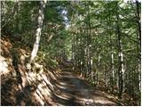 29
29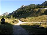 30
30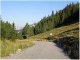 31
31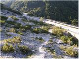 32
32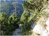 33
33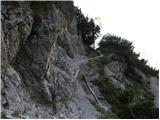 34
34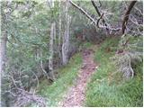 35
35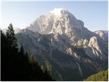 36
36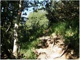 37
37 38
38 39
39 40
40 41
41 42
42 43
43 44
44 45
45 46
46 47
47 48
48 49
49 50
50 51
51 52
52 53
53 54
54 55
55 56
56 57
57 58
58 59
59 60
60 61
61 62
62 63
63 64
64 65
65 66
66 67
67 68
68 69
69 70
70 71
71 72
72 73
73 74
74 75
75 76
76 77
77 78
78 79
79 80
80 81
81 82
82 83
83 84
84 85
85 86
86 87
87 88
88 89
89 90
90 91
91 92
92 93
93 94
94 95
95 96
96 97
97 98
98 99
99 100
100 101
101 102
102 103
103 104
104 105
105 106
106 107
107 108
108 109
109 110
110 111
111
Discussion about the trip Planina Zajzera - Cima Alta (Due Pizzi) (path 648)
|
| meko11026. 02. 2011 |
Has anyone recently walked towards the top of Dve špici. What are the conditions to the bivouac and further on
|
|
|
|
| IgorZlodej26. 02. 2011 |
I don't know if you have an idea of these mountains, path 648 has been officially closed for two years, and winter access is not exactly easy, whether from Zajzera or through Dunjo,(road is plowed there only to the village Chiout Zucuin). Well to the bivouac it would probably go, substantially easier of course from the starting point Pian di Spadoavi (path 605). Also passage through the tunnel would still be possible, big problems would arise on the north side right at the exit from the tunnel, not to mention passage over the "carved ledge", which in winter is essentially impassable, so the question is quite off.
|
|
|
|
| falcon11. 03. 2011 |
Poldašnja peak reached, Pipar reached, for two years Dve špici have been eluding me. This year they must be reached. In dry conditions of course. Apparently the fixed cables at the exit from the tunnel have been repaired. Unless this winter destroyed them again. 
|
|
|
|
| Stane71. 05. 2011 |
When you succeed, let us know
|
|
|
|
| matic414. 06. 2011 |
In the above description it mentions two junctions "Right leads the path to Pipar (2069m) we continue left on path 468 towards bivouac Bernardinis", actually it's only one junction, and besides, the path marking is 648. The path to Dve Špici is not "closed for two years", but that applies to path no. 649 from Piparjev to Poldašnja špica (the entire path very overgrown, some cables under the scree, crossing dangerous). From the natural window onwards some cables are torn, the path quite overgrown, but relatively normally passable. Helmet essential, via ferrata set useless.
|
|
|
|
| roker62. 04. 2012 |
I agree with Matic. From the natural window onwards always torn or poorly tensioned wire rope, crumbly rock otherwise interestingly routed old military trail.
|
|
|
|
| (Z)Majček 23. 04. 2012 |
Since I plan to conquer Dve Špici on Friday, I'm wondering if anyone has been here recently and what the conditions are like?
|
|
|
|
| Stane726. 06. 2012 |
It seems there's not much traffic on this mountain, but still, are there any new information about this path available now?
|
|
|
|
| Okmodko26. 06. 2012 |
I'm also interested in information, specifically if you get two pizzas for the price of one? 
|
|
|
|
| Stane727. 06. 2012 |
No, one for the price of two.
|
|
|
|
| miri29. 06. 2012 |
No peculiarities. Caution around the gullies and on the ledge.
|
|
|
|
| Stane729. 06. 2012 |
Thanks for the reply. I was planning to go this weekend, but it fell through, hope it happens this year.
|
|
|
|
| Stane730. 07. 2012 |
Finally on Dve Špici. Conditions normal for this part of Italy, cables mostly torn, practically unusable, but you can go without them without major difficulties. The hardest part is right after exiting the natural window, extra caution is needed there. The ledge is wide enough to traverse it without issues. Of course anyone with vertigo problems has no business up there. Otherwise the path is well marked, no orientation issues. The eastern summit is only 5 minutes above the marked path and the ascent to it poses no difficulties.
Thanks miri for the info on ZS.
https://plus.google.com/u/0/photos/104712217680046368409/albums/5771026357999338705
|
|
|
|
| miri30. 07. 2012 |
Well, you made it. Congratulations
|
|
|
|
| Stane730. 07. 2012 |
Thanks.
I noticed I was very enthusiastic about using the words "no difficulties".
|
|
|
|
| Laščan21. 06. 2015 |
I'm interested in the condition of the cables at the passage through the natural window and on the ledge itself. Is it safely passable?
|
|
|
|
| VanSims22. 06. 2015 |
About two years ago the cables were in poor condition, and the trail was officially closed. I doubt anything has changed.
|
|
|
|
| Laščan22. 06. 2015 |
Thanks for the info, but I'm also interested if parking at the starting point is paid or only time-limited?
|
|
|
|
| jax22. 06. 2015 |
Here, if anyone is accidentally interested, I found this:
http://www.anaudine.it/wp-content/uploads/2015/05/Su-pei-monti.pdf
For those who don't understand Italian: yes, Sentiero Battaglione Gemona is still closed and we'll have to wait a bit more, but apparently they've decided to renovate it after all. The secured part supposedly this year, fully by 2017. If on schedule, of course...
Good news anyway.
|
|
|
|
| lukapet22. 06. 2015 |
Last year in autumn the trail was still officially closed. The cables are mostly all torn, but you can get through without them too. The trail is unproblematic to the bivouac, from the tunnel exit caution is needed. Especially where you cross small footbridges, which are also mostly collapsed, at the end at least the cable was still intact. Shame they don't renovate the trail, as it's very nice, and the view from the top even nicer. There are parking meters at the parking lot, we didn't pay, but I don't know how it is in season.
|
|
|
|
| svicr22. 06. 2015 |
Some fresh info from Naborjetski greben. Yesterday we were at Dve špici. We started at Dunja, where parking at Planina Plan dei Spadovai is not paid, but at the end of Zajzera it is!
To the Čanalut saddle we went via trail 605, which is in good condition. Before bivouac Bernardinis the first signs of renovation activity mentioned in the link added by "jax" are already showing. Further on trail 649 is officially closed. Cables are even more torn than years ago, wooden footbridges practically gone and no lighting in the tunnel either Whoever still goes to the western summit of Dve špici - Visoki vrh (2046m), should be especially careful in the section between the tunnel and the carved ledge.
Thrilled by the trail renovation news!
|
|
|
|
| matz20. 07. 2016 |
Does anyone have information if this path was renovated (as mentioned last year) or what condition it is in?
|
|
|
|
| Majki18. 08. 2016 |
Beginning of August 2016: conditions unchanged.
|
|
|
|
| punči17. 10. 2016 |
Yesterday my friend and I did a fantastic circular tour. From Val Dunja along path 605 to Dve špici where the path is completely renovated . The via ferrata cables still smell fresh  . After descending back to the saddle, there followed another good 150 m descent and then along marked path 649 turned left towards Visoki Pipar. A little below the ridge crest we turned left as we intended to visit the pathless Mali and Srednji Pipar, where the ascent should not exceed grade I. Since we didn't know exactly which was which, we circled all the little peaks in the ridge just in case . Which wasn't all that easy . We probably didn't find the easiest passages either, as in one section we climbed a fairly exposed II grade. Across Mali Pipar we continued to Srednji Pipar (which seemed much easier to me) and then descended to the saddle where we joined the marked path. The ascent to the last one, Visoki Pipar, is easy. The view is phenomenal! The whole path is wonderful and always very scenic. I have to admit that the Piparji are much nicer than Dve špici. Both the views and the path, and also much less visited. We returned along marked path 648, which leads a bit higher than the starting point. It was less than 15 min to the car. I'd attach some photos but unfortunately I don't know how . . After descending back to the saddle, there followed another good 150 m descent and then along marked path 649 turned left towards Visoki Pipar. A little below the ridge crest we turned left as we intended to visit the pathless Mali and Srednji Pipar, where the ascent should not exceed grade I. Since we didn't know exactly which was which, we circled all the little peaks in the ridge just in case . Which wasn't all that easy . We probably didn't find the easiest passages either, as in one section we climbed a fairly exposed II grade. Across Mali Pipar we continued to Srednji Pipar (which seemed much easier to me) and then descended to the saddle where we joined the marked path. The ascent to the last one, Visoki Pipar, is easy. The view is phenomenal! The whole path is wonderful and always very scenic. I have to admit that the Piparji are much nicer than Dve špici. Both the views and the path, and also much less visited. We returned along marked path 648, which leads a bit higher than the starting point. It was less than 15 min to the car. I'd attach some photos but unfortunately I don't know how .
|
|
|
|
| punči17. 10. 2016 |
thanks, little climbing thumb
|
|
|
|
| lukapet19. 10. 2016 |
Has the path to Bivacco Gemona perhaps also been restored? That section of the path is supposed to be impassable too.
|
|
|
|
| punči20. 10. 2016 |
lukapet, unfortunately I can't tell you that. But the markings along the ridge downward toward Poldašnja špica looked quite fresh, so I assume that part of the path is restored too. But these are just my guesses.
|
|
|
|
| lukapet29. 10. 2016 |
The trail has been renovated also on the section Monte Piper - bivak Gemona, checked today. There is a lot of scree on the path, so you need to be quite careful (especially on the steepest part). They are also renovating the bivouac, which should be opened in a few days.
|
|
|
|
| IgorZlodej29. 10. 2016 |
The trail will be officially open in June 2017, they still need to install some wire ropes under Piparji and set up new direction signs. Source C.A.I. Tarviso
|
|
|
|
| benja815130. 06. 2017 |
Does anyone have information on the current status of the path? Unfortunately, my Italian is not good enough to find anything on Italian alpine association websites... 
|
|
|
|
| ivanah30. 06. 2017 |
The path is well marked, the safety equipment is renewed.
Interesting and beautiful path.
|
|
|
|
| ljubitelj gora19. 08. 2018 |
Anyone who doesn't want to return the same way is better off going up from the Kanal Valley from the village of Naborjet.
|
|
|
|
| Paglia24. 09. 2020 |
On Sunday 21.9. we did this tour after a very long time. We started it from Zajzera, then down the asphalt road as described about 2 km and then along the path past the bivouac to the summit and back the same way.
The path is well marked throughout, the protections on the key section are almost completely renewed, so no problems. On the way back we also climbed the second summit which is just over 15 minutes from the marked trail and the path is also nicely visible.
The wilderness of the western Julian Alps is indescribably beautiful here.
One more tip: There are two main starting points:
1. From Zajzera, initial descent on the asphalt road, which you have to overcome uphill on the return when you're already tired.
2. From Dunja, there you initially climb up the road and at the end "stomp" downhill on asphalt which is easier but you have to reckon that Dunja is significantly farther by car than Zajzera.
|
|
|
|
| bbugari124. 09. 2020 |
From Dunja, no need to "stamp" along the asphalt, the direct approach is via path 605 from Dunjska cesta (elevation 1074) to sedlo Čanalot.
Approaches also from Naborje and Lužnice in Kanalska dolina.
The approach from Zajzera is boring and awkward, as it involves elevation loss.
|
|
|
|
| ločanka25. 08. 2021 17:50:59 |
On Sunday from Val Dunje along path No. 648 and return along path No. 605 to Planina Plan del Spadovai. Of course, then you have to go to the car waiting about 2 km higher. This means about 15-20 minutes of walking. Of course, it's worth doing a loop tour, especially if only the driver goes for the car.
The fixed protections are still nicely in place, but the critical area under the Piparjev wall remains, where you are exposed to loose scree on slippery terrain. You avoid this if you also ascend along path 605, and you don't have to walk to the car.
Otherwise, the valley is quiet, peaceful, no tourist crowds. Except for a couple of Slovenians and local Italians, no others were heard.
|
|
|
To post a comment you must log in:
If you do not yet have a username, you must first
register.