Planina Pungrat - Škrbina
Starting point: Planina Pungrat (1447 m)
| Latitude/Longitude: | 46,4286°N 14,3572°E |
| |
Walking time: 1 h 10 min
Difficulty: easy marked way
Elevation gain: 422 m
Elevation difference along the route: 422 m
Map: Karavanke - osrednji del 1:50.000
Recommended equipment (summer):
Recommended equipment (winter): ice axe, crampons
Views: 19.185
 | 4 people like this post |
Access to starting point:
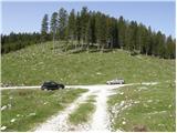
From the highway Ljubljana - Jesenice we take the Ljubelj exit. Further, we drive to the center of Tržič and follow the road through Dolžanova Gorge to the village Jelendol, where signs for mountain pastures Kofce, Šija and Pungrat direct us to the left. The road then loses the asphalt covering and starts ascending steeply. We follow this road at the crossroads in the direction of the mountain pasture Pungrat near which we park on one of the parking lots by the road.
Route description:
From the parking lot we first walk to the mountain pasture Pungrat, then a few tens of meters before the cottages on the mountain pasture we turn left onto a wide meadow, through which in a gentle ascent we climb to the edge of the forest, where we notice a mountain signpost for Škrbina (the initial part of the path is poorly marked).
We continue the ascent on a moderately steep forest path that rises above the mountain pasture Pungrat. After approximately 20 minutes of walking from the starting point, we step out of the forest onto increasingly steep slopes, first covered with brushwood then only with grass. The steep path brings us amid ever more beautiful views after a good hour of walking to Škrbina, from which a view opens up on the Austrian side.
Photos:
 1
1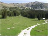 2
2 3
3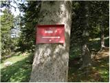 4
4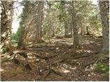 5
5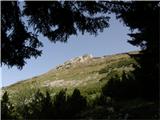 6
6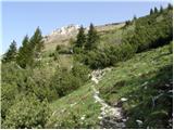 7
7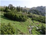 8
8 9
9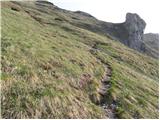 10
10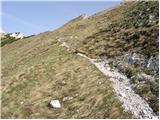 11
11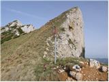 12
12
Discussion about the trip Planina Pungrat - Škrbina
|
| Kriška24. 08. 2009 |
The path from Planina Pungrat to Škrbina no longer exists. At the beginning of the path on the planina, on a tree under the direction sign "Škrbina 1 h" there is a new sign warning that the path to Škrbina is impassable. In the upper half of the path, most of the trail on a very steep slope was carried away by a wide, very extensive avalanche, the remaining trail up to there is slowly overgrown, although it is still visible at the moment.
|
|
|
|
| Kriška24. 08. 2009 |
The forest road from Jelendol to Planina Pungrat is in rather poor condition in the upper part at several places, driving with ordinary cars with low ground clearance is quite difficult. I recommend parking a bit lower along the road (at the place where in a left bend a traffic-closed forest path branches off to the right side of the road).
|
|
|
|
| Lunca3. 09. 2011 |
From Planina Pungrat, the path really needs a bit of searching, but there are no major difficulties, at the spot where the avalanche carried it away there are also no major issues, you cross that section, then you are quickly back on the right path...
|
|
|
|
| mmatejj7. 05. 2012 |
was last week .. the path is quite passable .. a sign at the edge of the forest boundary, at the fallen tree, that you need to turn left would be welcome .. at that small eroded section, a path is already forming along the edge, on the grassy part ...
|
|
|
|
| 4311. 05. 2014 |
this path is badly damaged by avalanche, I'd say most of it is gone ... we descended with ice axes over Škrbina to Pungrat ... about 100 m below Škrbina the path ends, as the avalanche took a good part of the ground with it ... then pathless descent to the edge of the forest, where we picked up the trail again ... terrain is steep, so off-path is tricky; if you don't have luck like us, you might also have to bushwhack through green thicket and forest ... not recommended ...
|
|
|
|
| pemi11. 05. 2014 |
Last year exactly on this part of the path due to such conditions I had an accident, I know the path well. On the descent, the guys who were higher above me recklessly triggered a rockfall and one of them flew into me, I carried it off fairly ..compared to what it could have been.
|
|
|
|
| michael6629. 08. 2014 |
What is the current condition of this path to or from Škrbina? Has anyone walked there in the last few days? Where is it possible to get from Kofce to Škrbina the fastest (and easiest)? What about the condition of the "graničarska pot" from pl. Šija towards Škrbina? LP.
|
|
|
|
| Lisica22. 10. 2017 |
The path from Planina Pungrat to Škrbina is normally passable and marked, nowhere visible that there was any landslide.
|
|
|
|
| Lapuh2075. 07. 2019 |
Today from Planina Pungrat to Škrbina and then along the ridge to the east. Path without peculiarities, but you can tell there's not much traffic here. Complete peace. Accordingly, sometimes you need to look more carefully which way to go next. Met only one single hiker, and even he turned towards Kladivo at Škrbina. Nice area. This year everything is still very green and everything smells of clove pinks. Recommended. The road to the pasture is also quite ok, especially considering the recent storms.
|
|
|
To post a comment you must log in:
If you do not yet have a username, you must first
register.