Planina Podvežak - Veliki vrh (Veža) (via Prag)
Starting point: Planina Podvežak (1500 m)
| Latitude/Longitude: | 46,3319°N 14,6726°E |
| |
Route name: via Prag
Walking time: 2 h 20 min
Difficulty: easy marked way
Elevation gain: 610 m
Elevation difference along the route: 750 m
Map: Kamniške in Savinjske Alpe 1:50.000
Recommended equipment (summer):
Recommended equipment (winter): ice axe, crampons
Views: 53.018
 | 5 people like this post |
Access to starting point:
First, we drive to Luče, then we continue driving into the Podvolovjek valley (direction Kamnik and Kranjski Rak). At the road sign between 11 and 11.5 km, we will arrive at a smaller intersection, where the road towards the farm Planinšek and mountain pastures Podvežak, Ravne and Vodole branches off to the right (turn-off is marked). We head onto this initially still asphalted road, which at the intersections we follow in the direction of the mountain pasture Podvežak. After a relatively long and in the upper part also worse macadam road, we will arrive at the parking lot below the mountain pasture Podvežak (at the starting point there is a gate and numerous signposts).
From Kamnik we drive towards the mountain pass Črnivec, but only to the intersection, where the road towards Kranjski Rak branches off sharply to the left (turn-off is marked and is located only 500 m before the mentioned pass). At the intersection at Kranjski Rak we continue straight on the main road, which starts descending into the Podvolovjek valley. In the mentioned valley only 100 m past the bar Gams we will arrive at an intersection, where the road towards the farm Planinšek and mountain pastures Podvežak, Ravne and Vodole branches off to the left (turn-off is marked). Further, follow the above description.
Route description:
From the parking lot, we head onto the footpath (or road) in the direction of the mountain pasture Podvežak. Both the road and the footpath, which during the ascent crosses a forest road, bring us in 15 minutes of moderate ascent to the shepherd's hut on the mountain pasture Podvežak, from which a beautiful view opens towards Rogatec and Lepenatka.
From the mountain pasture we continue on the marked but initially poorly visible path, which soon enters the forest. The path through the forest ascends somewhat more steeply, then transitions into a smaller unvegetated valley, above which it flattens out completely. This is followed by a few minutes traversing the slopes below the side ridge of Deska, then the path brings us to a less noticeable junction, where an unmarked path branches off to the left towards Deska and Vodotočno jezero. We continue straight on the marked path, which descends into a pleasant grassy plain, then turns somewhat to the right and ascends through a belt of dwarf pines. At the top of the ascent the path from the mountain pasture Vodole joins from the right, we continue left, cross the pasture fence and after a few more steps come to Inkretov studenec, which is located just a few meters from the path.
Only a gentle ascent follows, then the path flattens again and brings us below the relatively steep and in snow avalanche-prone slopes of Tolsti vrh. A little farther the pleasant path brings us to a marked junction, where we continue slightly right in the direction of the chapel on Molička peč (slightly left Korošica). The path ahead descends slightly, then continues in moderate ascent across a series of several smaller valleys. Soon we reach a smaller junction, where to the left a path branches off that returns to the marked path towards Korošica, to the right a path towards the mountain pasture Ravne and Dolga Trata. We continue straight on the wide and pleasant path, which after a few minutes of further walking brings us to the saddle Prag, where the next junction is.
We continue sharply right in the direction of the mountain pasture Ravne and Veliki vrh (straight Molička planina) on the path that crosses the slopes of Veliki vrh towards the southeast. After a few minutes of further walking we will notice by the path a small wooden sign with the inscription Veliki vrh, which directs us left onto a somewhat less visible trail that ascends through a belt of dwarf pines. Higher the trail becomes somewhat more distinct and gradually starts to ascend ever more steeply. The quite steep path along which numerous cairns assist us for easier orientation starts to fade higher up. Further we follow the poorly visible trail, which from the steep partly rocky section transitions into gentler grassy slopes. The poorly visible trail, which slowly turns towards the right, brings us after a few minutes of further walking to Veliki vrh, on which we notice a large cairn.

Photos:
 1
1 2
2 3
3 4
4 5
5 6
6 7
7 8
8 9
9 10
10 11
11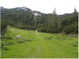 12
12 13
13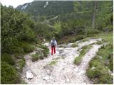 14
14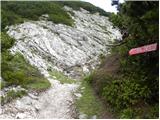 15
15 16
16 17
17 18
18 19
19 20
20 21
21 22
22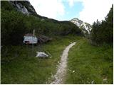 23
23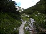 24
24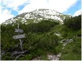 25
25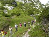 26
26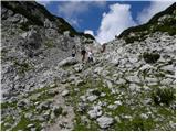 27
27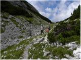 28
28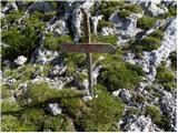 29
29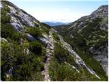 30
30 31
31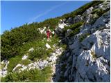 32
32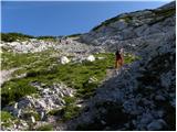 33
33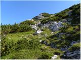 34
34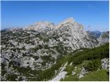 35
35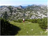 36
36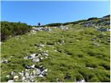 37
37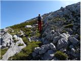 38
38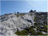 39
39 40
40
Discussion about the trip Planina Podvežak - Veliki vrh (Veža) (via Prag)
|
| ruševec14. 08. 2011 |
Yesterday I was at Veliki vrh from Planina Podvežak via the Prag saddle. Since all hiking guides, all maps and even here on hribi.net say that this is an unmarked path, I was surprised. At the place where the branch from the Prag-Planina Ravne path towards the summit should be, there is a very nicely marked junction. The entire path to Veliki vrh is newly marked! This raises the question for me, whether it is even allowed to newly mark hiking paths?
|
|
|
|
| starakapa18. 09. 2011 |
On June 1st this year the trail was not yet marked
|
|
|
|
| otiv18. 09. 2011 |
@MajaO The wooden sign was a few steps ahead and the start of the trail. I think Veliki vrh hasn't lost anything with the markings, maybe just gained a few more visitors.
|
|
|
|
| kicho31. 08. 2012 |
Yesterday did this tour, marked, trail well-maintained, view from the summit fantastic.
|
|
|
|
| pohodnik3818. 09. 2012 |
Some time ago (9.9.) walked this path, the view from Veliki vrh is really unique then continued towards Korošica to Lučki dedec and further to see Vodotočno jezero... nice circular tour
VIDEO-Dleskovška planota
|
|
|
|
| Grenaleva7. 07. 2014 |
The path to Veliki vrh via Podvežak really still has a lot of snow, which is not dangerous, but offers nice winter pleasures in the middle of summer.
|
|
|
|
| zokipoki7. 09. 2014 |
Yesterday at the summit. The path from the junction (Molička peč 30min-left/Veliki vrh-right) is simply wonderful. Steep and nicely marked, so despite yesterday's thick fog no problems with orientation.
First time I was alone on a mountain summit shrouded in thick fog.... the feeling is something special.
nice tour.
|
|
|
|
| Mirna16067. 10. 2018 |
Hello, what is the condition of the road to Planina Podvežak?
|
|
|
|
| garmont7. 10. 2018 |
Just like every year at the end of the season.
A bit torn up, but you can get to the parking lot with any car.
|
|
|
|
| alesfon30. 06. 2021 10:39:06 |
Yesterday walked this path and it's normally passable without winter gear. There's one snow patch on the path, which you bypass on the left side.
The summit is full of flowers.
|
|
|
|
| Lenore12. 09. 2021 11:07:22 |
I'm doing the transversal, but I'm not clear where the stamp is up here?
There are 2 boxes (one by the pile of stones, the other with a miniature shape of the Aljaž Tower).. both have a stamp (the same!) of some mountaineering association.. but no stamp for the transversal. 
|
|
|
|
| Gorazd G12. 09. 2021 12:30:00 |
On the summits, the "usual" summit stamps are imprinted in the logbook. This fully satisfies the rules.
"Special" SPP stamps are only in mountain huts.
|
|
|
|
| mirank12. 09. 2021 16:56:13 |
Since when is this summit in the traverse?
|
|
|
|
| garmont12. 09. 2021 19:29:48 |
Not this Veliki... but those in the Karavanke.
|
|
|
|
| franca12. 09. 2021 19:58:36 |
No, this one is in KS. Number 13 b (13 a is Mrzla gora), height 2110 m. Booklet from 2020, don't know from when it applies.
|
|
|
|
| Enka12. 09. 2021 20:12:12 |
In mine both are there (both on the extended one).
|
|
|
|
| garmont12. 09. 2021 20:46:42 |
In mine the first one... it's a bit older.
|
|
|
|
| Tajka6731. 05. 2025 21:51:23 |
Super nice hike, only in the upper part you have to search quite seriously for the path. The road is newly gravelled, no potholes anywhere, commendable. Despite wonderful weather, almost no one in this direction. I extended it to the chapel on Molička planina.
|
|
|
|
| nkamin13. 08. 2025 10:06:45 |
Please for information on the condition of the trail to Planina Podvežak
|
|
|
|
| garmont13. 08. 2025 11:38:21 |
If you're asking about the road, it's perfectly fine. Even for lower vehicles.
|
|
|
|
| nkamin13. 08. 2025 16:05:41 |
Yes, I'm asking about the road . Thanks for the message.
|
|
|
To post a comment you must log in:
If you do not yet have a username, you must first
register.