Planina Podvežak - Velika Zelenica (via Prag)
Starting point: Planina Podvežak (1500 m)
| Latitude/Longitude: | 46,3319°N 14,6726°E |
| |
Route name: via Prag
Walking time: 2 h 30 min
Difficulty: easy marked way
Elevation gain: 614 m
Elevation difference along the route: 700 m
Map: Kamniške in Savinjske Alpe 1:50.000
Recommended equipment (summer):
Recommended equipment (winter): ice axe, crampons
Views: 55.472
 | 3 people like this post |
Access to starting point:
First, we drive to Luče, then we continue driving into the Podvolovjek valley (direction Kamnik and Kranjski Rak). At the road marker between 11 and 11.5 km, we will reach a smaller intersection, where the road towards the Planinšek farm and mountain pastures Podvežak, Ravne and Vodole branches off to the right (the turn-off is marked). We head onto this initially still asphalted road, which we follow at the intersections in the direction of the Podvežak mountain pasture. After a relatively long and in the upper part also worse macadam road, we will arrive at the parking lot below the Podvežak mountain pasture (at the starting point there is a gate and numerous hiking signposts).
From Kamnik we drive towards the Črnivec pass, but only to the intersection where the road towards Kranjski Rak branches off sharply to the left (the turn-off is marked and is located only 500 m before the mentioned pass). At the intersection at Kranjski Rak we continue straight on the main road, which starts descending into the Podvolovjek valley. In the mentioned valley, only 100 m behind the Gams bar, we will come to an intersection where the road towards the Planinšek farm and mountain pastures Podvežak, Ravne and Vodole branches off to the left (the turn-off is marked). Further, follow the above description.
Route description:
From the parking lot, we head onto the footpath (or road) in the direction of the Podvežak mountain pasture. Both the road and the footpath, which during the ascent crosses a forest road, bring us in 15 minutes of moderate ascent to the shepherd's hut on the Podvežak mountain pasture, from which a beautiful view opens towards Rogatec and Lepenatka.
From the mountain pasture we continue on the marked but initially poorly visible path, which soon enters the forest. The path through the forest ascends somewhat more steeply, then transitions into a smaller unwooded valley, above which it completely flattens. This is followed by a few minutes of crossing the slopes below the side ridge of Deska, then the path brings us to a less noticeable junction where an unmarked path branches off to the left towards Deska and Vodotočno jezero. We continue straight on the marked path, which descends into a pleasant grassy plain, then turns somewhat to the right and ascends through a belt of dwarf pines. At the top of the ascent, the path from the Vodole mountain pasture joins from the right; we continue left, cross the grazing fence and after a few more steps arrive at the Inkretov studenec, which is located just a few meters from the path.
This is followed by only a gentle ascent, then the path flattens again and brings us below the relatively steep and in snow avalanche-prone slopes of Tolsti vrh. A little further, the pleasant path brings us to a marked junction, where we continue slightly right in the direction of the chapel on Molička peč (slightly left Korošica). The path ahead descends slightly, then continues in a moderate ascent across a series of several smaller valleys. Soon we reach a smaller junction where to the left a path branches off that returns to the marked path towards Korošica, and to the right a path towards the Ravne mountain pasture and Dolga Trata. We continue straight on the wide and pleasant path, which after a few minutes of further walking brings us to the Prag saddle, where the next junction is.
We continue sharply right in the direction of the Ravne mountain pasture and Veliki vrh (straight Molička planina) on the path that crosses the slopes of Veliki vrh towards the southeast. After a few minutes of further walking, we will notice by the path a small wooden sign with the inscription Veliki vrh, which directs us left onto a somewhat poorly visible track that ascends through a belt of dwarf pines. Higher up, the track becomes somewhat more distinct and gradually begins to ascend more and more steeply. The quite steep path, alongside which numerous cairns aid our orientation, starts to fade higher up. Further, we follow the poorly visible track, which from the steep partly rocky section transitions into gentler grassy slopes. The poorly visible track, which slowly turns to the right, brings us after a few minutes of further walking to Veliki vrh, where we notice a large cairn.
From Veliki vrh we continue left (direction north to northwest) on the poorly visible track, which moderately descends to the col between Veliki vrh and Velika Zelenica. At the col, the path from the Ravne mountain pasture also joins from the right; we continue in the same direction and continue the ascent across the gentle grassy slope, after which in a few minutes of further walking we ascend to the panoramic summit.

Photos:
 1
1 2
2 3
3 4
4 5
5 6
6 7
7 8
8 9
9 10
10 11
11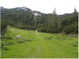 12
12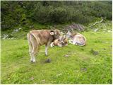 13
13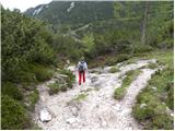 14
14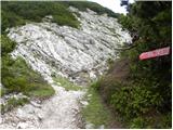 15
15 16
16 17
17 18
18 19
19 20
20 21
21 22
22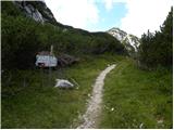 23
23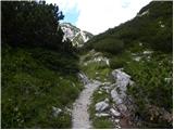 24
24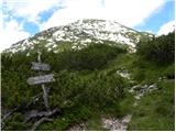 25
25 26
26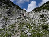 27
27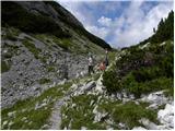 28
28 29
29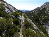 30
30 31
31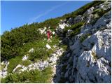 32
32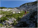 33
33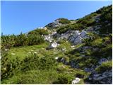 34
34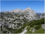 35
35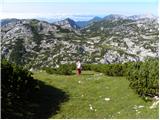 36
36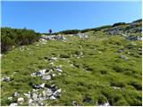 37
37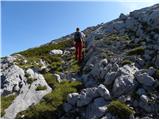 38
38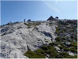 39
39 40
40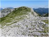 41
41 42
42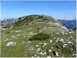 43
43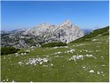 44
44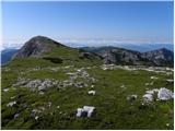 45
45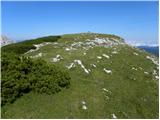 46
46 47
47
Discussion about the trip Planina Podvežak - Velika Zelenica (via Prag)
|
| garmont8. 12. 2011 |
The mentioned path has been marked since this year.
Lp
|
|
|
|
| savinjcan658. 12. 2011 |
Likewise the path from the neighboring planina is newly marked, specifically on both sides below Dloskovec.
l.p.
|
|
|
|
| Alni23. 07. 2012 |
What is the road to the starting point like? Approximately how much time can I expect for the gravel section and in what condition is it?
|
|
|
|
| otiv23. 07. 2012 |
The road to Planina Podvežak is mostly gravel, which of course is not very smooth. But you reach such a height in half an hour that all those jolts during the drive are compensated.
Good luck!
|
|
|
|
| amarilis23. 07. 2012 |
Although the road is macadamized they maintain it quite well; but you shouldn't mind
your car, on such a road! 
Regards
|
|
|
|
| amarilis23. 07. 2012 |
Although the road is macadamized they maintain it quite well; but you shouldn't mind
your car, on such a road!
Regards
|
|
|
|
| amarilis23. 07. 2012 |
Although the road is macadamized they maintain it quite well; but you shouldn't mind
your car, on such a road!
Regards
|
|
|
|
| seinfeld21. 07. 2013 |
Today we did this nicely marked path. Two and a half hours is a bit exaggerated, with fairly moderate pace and several stops, we needed two hours and a quarter. Plus ten minutes to Veliki vrh. The path is wonderful, the last 200 elevation meters are quite steep. Views are unique, the peaks of Dleskovska planota and Ojstrica are as if on the palm of your hand.
|
|
|
|
| pjoter28. 07. 2013 |
I'm wondering if anyone knows whether there's a summit logbook and stamp at the top
thanks
|
|
|
|
| Fulcrum29. 07. 2013 |
The logbook and stamp are at Veliki vrh, which is approx. 10 min away from Velika Zelenica.
|
|
|
|
| bruny7. 09. 2013 |
Today in the quiz  a bit bottom left. I'm interested based on the description and photos if this is one of the easier 2000ers in the Slovenian mountains and how far roughly from end of asphalt to planina Podvežak, because I would also a bit collect mileage if I decide for ascent to this peak...Probably the best starting point is the description on this portal Planica(Planinšek) - planina Podvežak or am I wrong. Lp a bit bottom left. I'm interested based on the description and photos if this is one of the easier 2000ers in the Slovenian mountains and how far roughly from end of asphalt to planina Podvežak, because I would also a bit collect mileage if I decide for ascent to this peak...Probably the best starting point is the description on this portal Planica(Planinšek) - planina Podvežak or am I wrong. Lp
|
|
|
|
| michael6624. 09. 2015 |
Has anyone driven the road to Planina Podvežak recently? What's the road like?
|
|
|
|
| Tomaž1124. 09. 2015 |
Nice Asphalt to Planinška or a bit further, macadam also in pretty good condition.
|
|
|
|
| nommi28. 09. 2017 |
Does anyone know if there's still any snow around Velika Zelenica?
|
|
|
|
| ribnik17. 10. 2017 |
Beautiful path and pleasant trip with a great view from the top! Recommended!
|
|
|
|
| aditaker18. 07. 2018 |
I'm interested if someone can tell me approximately how much walking to the summit if I leave the car where the asphalt ends, so I wouldn't need to drive on gravel, because it's a pity for my car. And if it's possible to park nearby there at the end of asphalt too?
Best, Rok
|
|
|
|
| drdivx18. 07. 2018 |
@aditaker
Just leave it down at the Podvolovjek sign, because it's a pity to drive up those hills. Even downhill the brakes suffer and it's really a pity for the car.
If you insist on the end of asphalt, know that Planinšek's livestock grazes there and often crosses the road. You might get a horn through the windshield as a souvenir.
|
|
|
|
| keti119. 07. 2018 |
The road here has always been solid (haven't driven it this year yet), so with slow driving you won't damage the car, lp
|
|
|
|
| Gora Trma19. 07. 2018 |
Also in my opinion this is one of the best gravel access roads in the Slovenian mountains
|
|
|
|
| aditaker19. 07. 2018 |
drdivx or someone else please tell me where exactly this podvolovljek sign is located and where the parking is nearby, because I really won't risk my new car and how much walking is there from that sign to the top?
thanks in advance for the answer and best regards Rok
|
|
|
|
| garmont19. 07. 2018 |
You still have asphalt a bit further from Planinšek, that's around 1000m high. Since you care about your car, you probably really can't just park by the road. 
But to go from Podvolovljek because of the car is really over the top. 
|
|
|
|
| drdivx19. 07. 2018 |
@aditaker
I really wrote a slightly malicious remark to you, but know that you bought the car to get somewhere, not to pamper it up the hill.
Asphalt to the Planinšek farm is newer, further on it's solid gravel and with slow driving you can drive nicely. Usually a bit worse is the road to planina Ravni. Realize that you have a car for getting somewhere, not to still walk on foot. Good luck
|
|
|
|
| biba19. 07. 2018 |
If you insist, you can leave the car at the first junction/crossroads (Podveža/Ravne) behind the Planinšek farm (Podveža 44) and you have surely about an hour of walking to the starting point (Podveža 46)... check the map or enter into Google maps (now you have the address). Good luck!
|
|
|
|
| aditaker20. 07. 2018 |
drdivx thanks for the reply, yes the car is for getting somewhere with it, but I don't like driving in the mountains, I prefer walking and a bit running, so I rather leave the car as low as possible in the valley to have as much walking as possible, but really I like walking only on hiking trails not on asphalt.
|
|
|
|
| aditaker20. 07. 2018 |
Oh, and one more question: is there a stamp at the top, because I need it for a hiking badge?
Best regards, Rok
|
|
|
|
| drdivx20. 07. 2018 |
There are two stamps up there. At least there were.
One is located in that mini replica of the Aljaž Tower, the other in the box where the logbook is. Someone who was up there this month will answer if it's still the case.
|
|
|
|
| djimuzl20. 07. 2018 |
Yes, but on Veliki vrh, not Zelenica, there's nothing there.
|
|
|
|
| garmont26. 05. 2021 19:11:32 |
Snow everywhere.
|
|
|
|
| Redi3356. 06. 2022 16:54:39 |
How are the road conditions? Is it passable?
|
|
|
|
| garmont6. 06. 2022 19:52:00 |
The road is worse from the junction to Podvežak. Slowly, but it goes.
|
|
|
|
| panoramik7. 06. 2022 11:26:29 |
With Touareg V6 R eHybrid easily
|
|
|
|
| garmont7. 06. 2022 14:51:28 |
On Saturday there was no Touareg here, or anything similar…
|
|
|
To post a comment you must log in:
If you do not yet have a username, you must first
register.