Planina Blato - Zasavska koča na Prehodavcih (Za Kopico)
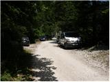
Starting point: Planina Blato (1147 m)
| Latitude/Longitude: | 46,3112°N 13,8501°E |
| |
Route name: Za Kopico
Walking time: 5 h 5 min
Difficulty: easy marked way
Elevation gain: 924 m
Elevation difference along the route: 1250 m
Map: Triglav 1:25.000
Recommended equipment (summer): helmet
Recommended equipment (winter): helmet, ice axe, crampons
Views: 79.597
 | 4 people like this post |
Access to starting point:
From the Ljubljana-Jesenice motorway, take the Lesce exit and follow the road towards Bled and further towards Bohinjska Bistrica. Continue driving towards Lake Bohinj (Ribčev laz), where you reach a junction and continue right towards Stara Fužina. In Stara Fužina, at the junction by the chapel, turn sharply left onto the ascending road towards planina Blato, planina Vogar and dolina Voje. The road then takes you to the toll and parking fee collection point, but follow it further to the next junction, where you continue left (right to Voje). Then follow the road to the next junction (it takes quite some time driving), where you turn sharply right towards planina Blato (straight to planina Vogar). Follow this road to the parking lot before planina Blato.
Route description:
From the marked parking lot in front of Planina Blato, return a little back and head onto a wide and initially also steep cart track, along which there are signs for Planina pri Jezeru. After about ten minutes of ascent, you arrive at a marked junction, from where you continue left towards Planina pri Jezeru (slightly right Planina v Lazu and also the steep path towards Planina pri Jezeru).
Continuing on the less steep cart track, which continues to lead through the forest, a marked path joins from the left a little further on, leading past Kosijev dom on Vogarju, but we continue right and keep walking on the cart track. Higher up, the path leads through a small narrow passage, then crosses fairly steep slopes where there is a high risk of slipping in ice and snow, otherwise the path is not demanding. At the end of the steep slope, the aforementioned steep path joins unobtrusively from the right, the cart track turns left here and enters the fairly cool Pungrat valley, where we ascend through mostly spruce forest. When the path levels out higher up, another path joins from the left leading past Planina Vodični vrh, but we keep slightly to the right and continue walking on the cart track, along which the forest begins to thin. A few minutes of easy walking follow and we step onto the pastures of Planina pri Jezeru, where the Koča na Planini pri Jezeru stands on a small hillock.
At the hut, a path branches right towards Planina v Lazu, but we continue left from the hut and descend to a marked junction where there are also a few shepherds' huts.
Choose the wider right path along which there are signs for Planina Dedno polje and Koča pri Triglavskih jezerih (slightly left Pršivec, Planina Viševnik and Črno jezero).
Continuing ascent on the cart track, which is quite rocky on steep sections, after about ten minutes of ascent we reach the point where a path branches left over Krištofojca towards Planina Viševnik, but we continue straight on the gradually less steep cart track leading through gradually sparser forest. A few minutes of easy walking follow on the path, which later turns slightly right, and when the path turns back towards the west, we already reach the edge of Planina Dedno polje, from where a walk follows to the central part of the pasture, where there is also a marked junction by the shepherds' huts.
Here we leave the wide path leading straight towards Koča pri Triglavskih jezerih and nearby Planina Ovčarija and continue right on the path towards Zasavska koča na Prehodavcih, preval Vratca and sedlo Hribarice. The path further leads past a few huts on the pasture, behind which a path branches right towards Planina v Lazu, Planina Krstenica and Vodnikov dom na Velem polju, but we continue straight to the northwest part of the pasture, where the path begins to ascend. Here the path first leads past a dry watering place for animals, then the path becomes steeper and ascends through mostly coniferous forest of spruces and larches. After about thirty minutes of steep ascent, the path levels out and brings us to a kind of saddle between Kovačičeva glava on the left and Kredo on the right.
A little further from the saddle, which can be traced by the name Stog, an unmarked path branches right towards Slatna, and we get the first beautiful views of the mountains rising above the Za Kopico valley. A traverse ascent follows above the abandoned Planina Ščavje, the path gradually moves from the slopes of Slatna to the slopes of Prvi Vogal, and higher up the view increasingly catches the interesting rocky peak of Kopica rising on the left, western side of the Za Kopico valley.
Higher up we gradually arrive in the central part of the valley, where from the slopes we enter a series of several smaller valleys, through which we mostly ascend moderately, only occasionally a shorter steeper section follows. With beautiful views, we continue upwards through the wonderful landscape, the valley narrows higher up and at 2192 meters above sea level we reach preval Vratca, which separates the Za Kopico valley from the Dolina Triglavskih jezer.
From the pass, located between Velika Zelnarica on the left and Zadnji Vogal on the right, from the marked junction continue straight towards Prehodavci, Hribarice and Dolič (sharply left Mala Zelnarica, Mala Tičarica, Štapce, Planina Ovčarija and Koča pri Triglavskih jezerih) and begin a traverse descent on the scree of Zadnji Vogal. The path ahead levels out temporarily and leads us for a short time through flatter terrain, then we reach the slopes of Vršaki, where the slope gradually becomes steeper, on a shorter section also somewhat slippery, when the slopes become less steep we reach a marked junction below Hribarice.
Continue left downhill towards Prehodavci (right Kanjavec, Hribarice, Dolič and Triglav) and begin a traverse descent on the scree below Poprovec, lower down the path turns slightly left and brings us to a junction, from where we continue slightly right towards Zasavska koča na Prehodavcih (left Zeleno jezero and Koča pri Triglavskih jezerih). A few minutes of moderate descent follow and we arrive at Rjavo jezero or Rjava mlaka.
At the lake, another path branches left to Zeleno jezero, which then leads lower to Koča pri Triglavskih jezerih, but we continue straight, or right and begin ascending towards the hillock above Rjavo jezero. More than ten minutes of ascent follow and we reach a panoramic ridge, which we reach at the winter room on Prehodavci, but we go right here and quickly arrive at Zasavska koča na Prehodavcih.
Starting point - Planina pri Jezeru 1:00, Planina pri Jezeru - Planina Dedno polje 0:30, Planina Dedno polje - Stog 0:30, Stog - Vratca 1:40, Vratca - junction below Vršaki 0:45, junction below Vršaki - Rjavo jezero 0:25, Rjavo jezero - Zasavska koča 0:15.

Photos:
 1
1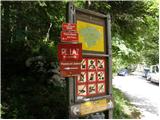 2
2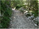 3
3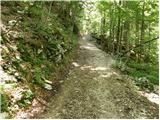 4
4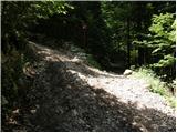 5
5 6
6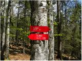 7
7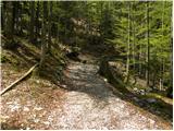 8
8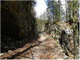 9
9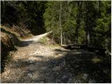 10
10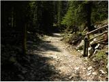 11
11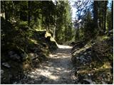 12
12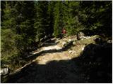 13
13 14
14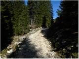 15
15 16
16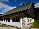 17
17 18
18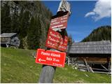 19
19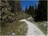 20
20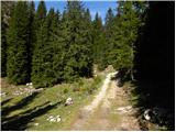 21
21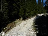 22
22 23
23 24
24 25
25 26
26 27
27 28
28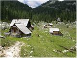 29
29 30
30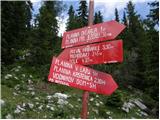 31
31 32
32 33
33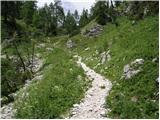 34
34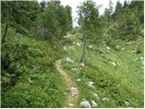 35
35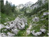 36
36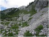 37
37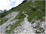 38
38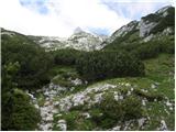 39
39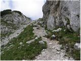 40
40 41
41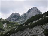 42
42 43
43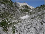 44
44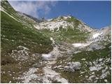 45
45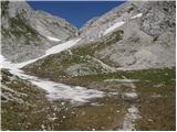 46
46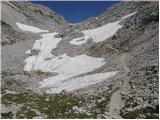 47
47 48
48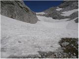 49
49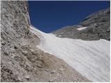 50
50 51
51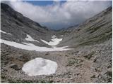 52
52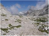 53
53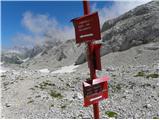 54
54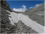 55
55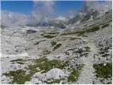 56
56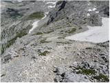 57
57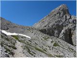 58
58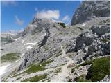 59
59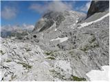 60
60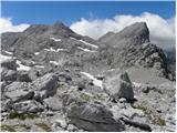 61
61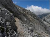 62
62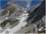 63
63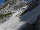 64
64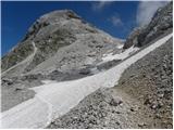 65
65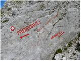 66
66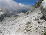 67
67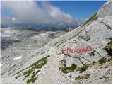 68
68 69
69 70
70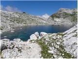 71
71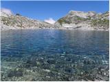 72
72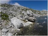 73
73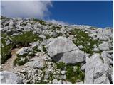 74
74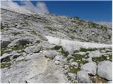 75
75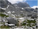 76
76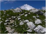 77
77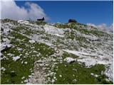 78
78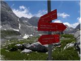 79
79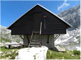 80
80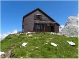 81
81
Discussion about the trip Planina Blato - Zasavska koča na Prehodavcih (Za Kopico)
Show older messages
|
| Gost16. 08. 2007 |
We cross the slopes of Vršakov and reach a somewhat more difficult passage under Vršaki (slightly exposed).
What does slightly exposed mean and is the passage possible with children???
|
|
|
|
| Gost16. 08. 2007 |
Well, this trail interests me too. What does this more difficult passage under Vršaki look like? Is it secured or free... Or is this the only passage to Planina pri Jezeru? Thanks for the answer and good luck!
|
|
|
|
| Gost16. 08. 2007 |
Honestly: I wouldn't have even noticed it myself if I hadn't been warned about it. The hike is exceptionally beautiful (especially the valley Za Kopico) and undemanding - suitable also for children if they have some mountain experience (it's quite long). I also recommend visiting nearby Kanjavec, which is similarly easy and not too frequently visited.
This is not the only passage from Koča na Prehodavcih. A relatively equivalent one is the one through the valley of Triglav Lakes (maybe even more exciting), but this one is undoubtedly my favorite, for the sake of solitude, silence and the unique beauty of the Za Kopico valley.
|
|
|
|
| Gost17. 08. 2007 |
Thank you very much for the reply. I've hiked the path through the valley of the seven from Prehodavci several times (last time a month ago). This one to Kopica is calling me, and I have in mind a nice loop for a three-day trip around here (Pokljuka - Velo polje - Dolič - Prehodavci - Za Kopico to Planina pri jezeru - Lazovški preval - Mišeljski preval - Velo polje - Pokljuka). Precisely the fact that not many people go there attracts me even more. Thanks and all the best! MiR
|
|
|
|
| Filip&Jakob8. 08. 2008 |
Yesterday on 6th and 7th August 2008 we hiked this trail as a family (child is 8 years old). The trail is beautiful and easy, for children it can be long if they lose motivation. We slept at Prehodavcih and the next day down the valley of Triglav lakes to the hut and back to Blato via Štapce. On the trail we saw many edelweiss and chamois, my son was extremely excited about the beauty of the mountains! Highly recommended!
|
|
|
|
| mukica13. 10. 2008 |
On a beautiful Sunday without a cloud, no wind, extremely warm weather we went to Kopica to Prehodavci, snacked by the bivouac then down the 7J valley through Prode to the starting point. Larches shone in the sun, full of visitors, too bad all huts are already closed.
|
|
|
|
| janezt17. 08. 2009 |
Very nice path suitable for children over 8 years.
On the path you're almost alone and enjoy the beauty and silence of the mountains. Recommended.
|
|
|
|
| urshy17. 08. 2009 |
Gorgeous hike. From Planina Blato to Koča na Sedmerih it's good 2.5 hours of very easy walking, then another good two hours to Zasavska koča on Prehodavcih with a stop at Ledvička. Exceptionally beautiful landscape, one of the nicer hikes.
|
|
|
|
| pika_nogavicka17. 08. 2009 |
Yes really super hike. We were here also with parents, I was really surprised by the beauties of Slovenia 
|
|
|
|
| pika_nogavicka17. 08. 2009 |
Back we went through the valley Za Kupico. The wind was really blowing hard 
|
|
|
|
| Urshka16. 08. 2010 |
Hello, I have a technical question, I'm a newbie and still don't know my way around the information about hikes. 
When it says the hike time is 5 hours, does that mean one way or the whole tour (up and down)?
|
|
|
|
| Kriška16. 08. 2010 |
The hike duration is meant one way (from start point to summit), except for circular tours. Times are always relative, just indicative, as there can be significant individual deviations. For the same tour you can find different time data if you compare the time in the mountaineering guide, on hribi.net, on signs on site.
In the "old days" it was considered that 300 elevation meters require 1 hour of walking.
|
|
|
|
| turbo16. 08. 2010 |
One way! 
|
|
|
|
| Urshka16. 08. 2010 |
Thanks to both of you for the information!
I really like the advice from user Filip&Jakob, if it's not too strenuous, my boyfriend and I will take this tour.
|
|
|
|
| olgam9. 08. 2011 |
What about snow patches at this time? There are quite a few visible, although I don't know when the photos were taken.
|
|
|
|
| Lj9. 08. 2011 |
A week ago there was no snow patch on this path, and surely there isn't now either.
Best regards, Ljubica
|
|
|
|
| olgam10. 08. 2011 |
Lj, thanks a lot for the answer!
I thought it would be like that. This path strongly attracts me. Hoping for weather and some bed for sleeping at Prehodavcih this weekend....
|
|
|
|
| StyLa29. 08. 2011 |
On Saturday 28.10. I set off on a circular tour from Planina Blato via Štapci to Triglavska koča at Dvojno jezero and then up the valley of Triglav lakes to Zasavska koča na Prehodavcih, and back via the Za Kopico valley. For those who will be around there for the first time and returning via this path (as I did this weekend) I would just add that both at Zasavska koča and at the junction by Zeleno jezero you need to follow the direction Hribarice (the only sign for that direction) and that the path to Dedno polje branches off only in the middle of the Vršaki slope.
The path is otherwise very pleasant for descent, and you might even spot a marmot along the way
|
|
|
|
| katty30. 08. 2011 |
Yes, this path is really very nice. I walked it on 14.8 in the opposite direction. I agree, on the path over Kopica you meet only a handful of people, which is really great . The path over Tičarica towards Kopica and Zeljarica is mostly flat, except the last part rises anyway. Too bad there's no stamp cloth at the top, so I'll have to take this path again. . The path over Tičarica towards Kopica and Zeljarica is mostly flat, except the last part rises anyway. Too bad there's no stamp cloth at the top, so I'll have to take this path again.
|
|
|
|
| Bosstjan22. 07. 2013 |
Hello. I'm interested in whether there is still any snow patches on this path or, if there are, how demanding they are.
|
|
|
|
| jasminka3. 05. 2014 |
Beautiful tour... gorgeous pictures!!! Congratulations!
|
|
|
|
| potočan3. 05. 2014 |
Excellent, but what does that mean time-wise?
|
|
|
|
| robi143. 05. 2014 |
In snow-free conditions with all stops and also with Kanjavec, 10 hours and over 30 km.
|
|
|
|
| slamca15. 07. 2014 |
Hello,
I'm interested in what the conditions are regarding snow patches on this path, if anyone has been walking around here recently.
|
|
|
|
| funnyboy15. 07. 2014 |
There is still quite a bit of snow. It persists from the upper part of the Za Kopico valley to the foot of Hribarice (of course, some cleared sections of the path in between)
|
|
|
|
| slamca15. 07. 2014 |
Thanks for the info. I'll wait a bit more for the snow to melt and preferably via the 7J valley.
|
|
|
|
| lukk24. 07. 2014 |
I'm interested in the current conditions, if anything has changed and if winter gear is needed.
|
|
|
|
| slamca24. 07. 2014 |
Last Saturday when I was up there, they advised against crossing Hribarice without winter gear at the hut. There should be a variant along the hunter's trail, but I don't know exactly where it goes.
|
|
|
|
| lukk24. 08. 2014 |
I'm interested in the conditions on the path, if there's still any snow and what the danger is.
|
|
|
|
| lukk7. 09. 2014 |
Has anyone been here this week and knows what the path conditions are like?
|
|
|
|
| lukk15. 09. 2014 |
I'm interested in what the conditions on the trail are like and how much snow there is, if it's worth taking this trail which hasn't been favorable to us this year.
|
|
|
|
| lukk23. 09. 2014 |
I'm interested in the conditions on the path, how much snow there is in the valley.
|
|
|
|
| slamca7. 07. 2016 |
Hello. I'm interested if anyone knows if there is still snow on the path. Especially from Vratca towards Prehodavci. Thanks for the answer.
|
|
|
|
| potka8. 07. 2016 |
Hi, to Kopica snow-free, I went last Saturday, for further ahead maybe someone has some more infoGood luck
|
|
|
|
| Jure 28. 07. 2016 |
Hi. Some mud, nothing worth mentioning. Dry under Vršaki.
|
|
|
|
| slamca8. 07. 2016 |
Jure 2, many thanks for the reply.
Potka, likewise to you.
Then this path will do for traversing.
|
|
|
|
| slamca9. 07. 2016 |
Excellent conditions. The path is passable without issues, just a bit of caution needed on the snowfield.
|
|
|
|
| sara175626. 09. 2017 |
Hello, has anyone hiked this path in recent days? Still much snow in Za Kopico valley?
Thanks
|
|
|
|
| Jure 226. 09. 2017 |
Hi. Here and there still some patch to be found.
|
|
|
|
| mlgt19508. 07. 2018 |
Does anyone have information about the path Prehodavci-Za Kopico-Planina Dedno polje-Planina pri Jezeru. Is the section of the path under Vršaki, under Zelnarica and under Za Kopico really quite overgrown, poorly visible and poorly marked? Is this path recommended at all?
Thanks for any information.
|
|
|
|
| Enka8. 07. 2018 |
I don't know where you got that information from. The path is normally marked and visible and traceable all the time.
|
|
|
|
| valerija1128. 07. 2018 |
This is part of the Best Hiking Trail 2018.
Beautiful tour, I recommend it.
|
|
|
|
| mlgt19508. 07. 2018 |
Thanks to both for the information.
best regards
|
|
|
|
| urh11130. 07. 2018 |
Is the hike suitable also in hot days? Probably exposed to the sun all the time? Does anyone remember the conditions?
Thanks.
|
|
|
|
| kdoveodkod30. 07. 2018 |
Was there last week, fortunately in slightly cloudy weather. The valley Za Kopico is really sun-exposed at midday, like all high mountain paths without vegetation.
|
|
|
|
| Zzabaa7. 09. 2020 |
Yesterday we went up via Prode and down via Vratca. The sun is not too intense, but on the way back you have to watch out not to miss the path at Rjavo jezero
|
|
|
|
| pigiron11. 09. 2020 |
On 9.9.2020 we went along the described path from Koča na Planini pri Jezeru to Zasavska koča na Prehodavcih and returned to the starting point via Dolina triglavskih jezer (via Prode). This looped "sausage" is almost 23 km long, but in such beautiful and clear weather it is immensely picturesque.
I am posting because during the descent from preval Vrata to Rjavo jezero you need to be very careful. The mentioned, somewhat exposed ledge is no problem compared to crossing the otherwise wide path over fine "scree" all the way to the junction with the path from Hribarice, which is partially covered and requires using hands (without poles). The path over rocks to Rjavo jezero is also difficult, where there is almost no passage or it is very poorly marked. Namely, there are no markers, and the directional lines are practically erased. Thus, the passage presents a small challenge. The path from Prehodavci to Planina pri Jezeru is marked more than exemplarily.
|
|
|
|
| toni989. 07. 2021 14:39:02 |
Hi. Does anyone know how the snow situation is currently? Is winter gear needed? thanks
|
|
|
|
| bo_zl9. 07. 2021 16:39:50 |
also: at the trail junction at Dedno polje it says winter gear is mandatory and to therefore use the trail over the 7 lakes.
|
|
|
|
| Rajskioskar21. 06. 2022 10:56:46 |
Hello.
Has anyone walked the mentioned path (Za Kopico) in the last few days? Since I'm planning a trip with the kid, I'm interested in how much snow is left. Thanks for any info.
|
|
|
|
| _sandra_21. 06. 2022 11:12:38 |
On 12.6. there were still 2 snow patches, but maybe they're gone now, given the high temperatures.. best regards
|
|
|
|
| Rajskioskar21. 06. 2022 11:36:44 |
_sandra_, sincere thanks. So, I assume I don't need to worry about that and can give the green light even to the 7-year-old.
Safe steps and all the best.
|
|
|
To post a comment you must log in:
If you do not yet have a username, you must first
register.