Planina Blato - Planina Krstenica (hunter's way)
Starting point: Planina Blato (1147 m)
| Latitude/Longitude: | 46,3112°N 13,8501°E |
| |
Route name: hunter's way
Walking time: 1 h 30 min
Difficulty: easy unmarked way
Elevation gain: 523 m
Elevation difference along the route: 523 m
Map: Triglav 1:25.000
Recommended equipment (summer):
Recommended equipment (winter): ice axe, crampons
Views: 50.399
 | 5 people like this post |
Access to starting point:
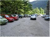
From the Ljubljana - Jesenice motorway, take the Lesce exit and follow the road towards Bled and further towards Bohinjska Bistrica. Continue driving towards Lake Bohinj (Ribčev laz), where we reach a junction and continue right towards Stara Fužina. In Stara Fužina, at the junction by the chapel, turn sharply left onto the ascending road towards Planina Blato, Planina Vogar and Voje Valley. The road then takes us to the toll and parking fee collection point, but we follow it further to the next junction, where we continue left (right to Voje). Then follow the road to the next junction (it takes quite some time driving), where we turn sharply right towards Planina Blato (straight to Planina Vogar). Follow this road to the parking lot above Planina Blato.
Route description:
From the parking lot, continue on the gravel road which takes us past the barrier in a few steps to a right bend. On the right side of this bend, we will notice the start of the hunter's path, which with the aid of a fixed cable leads us over a short very steep slope. The path soon enters the forest and turns slightly to the right, soon crossing a wide cart track (you can also go by road up to here, or higher on the cart track).
Further on, we ascend along a pleasant forest path that climbs parallel to a relatively steep cart track. Higher up, the path turns left, and from the right a trail joins us that leaves the cart track about 15 minutes above Planina Blato.
The hunter's path continues through the forest with some short steep ascents and after about an hour of walking brings us to a small hunter's hut located on the left side of the path. Here, a one-minute path also branches off to the left to a viewpoint where we can observe Planina Blato below us.
From the hunter's hut onwards, the path soon takes us out of the forest, where we rejoin the cart track. Only another five minutes of walking remain to Planina Krstenica, where a beautiful view opens up of Ograde, Krn and the Bohinj - Tolmin mountains, sometimes called the Lower Bohinj Mountains.
Starting point - hunter's hut 1:15, hunter's hut - Planina Krstenica 0:15.

Along the route: Lovska koča (1588m)
The trip can be extended to the following destinations: Planina Jezerce ( 30 min),
Krsteniški Stog ( 45 min),
Jezerski Stog (1 h 30 min),
Prevalski Stog,
Ogradi (1 h 45 min),
Škednjovec (3 h),
Vrh Hribaric (3 h 45 min),
Vršaki (Vrh za Koritami) (4 h 25 min),
Vršaki (Srednji vrh) (4 h 5 min),
Vršaki (South peak) (4 h 35 min),
Vršaki (Vzhodni vrh) (3 h 45 min),
Teme (Hribarice) (4 h 50 min),
Poprovec (5 h 5 min),
Kanjavec (4 h 30 min),
Kanjavec (West peak) (4 h 30 min)
Photos:
 1
1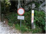 2
2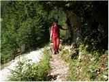 3
3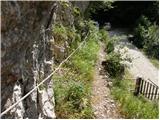 4
4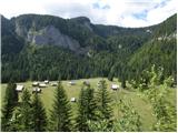 5
5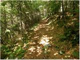 6
6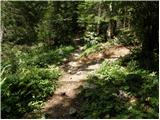 7
7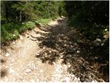 8
8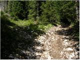 9
9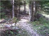 10
10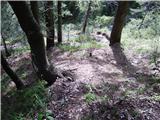 11
11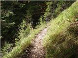 12
12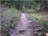 13
13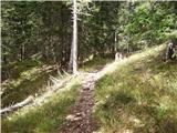 14
14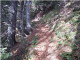 15
15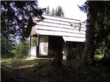 16
16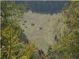 17
17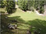 18
18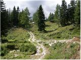 19
19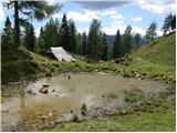 20
20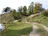 21
21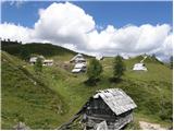 22
22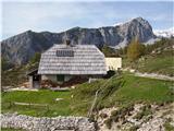 23
23
Discussion about the trip Planina Blato - Planina Krstenica (hunter's way)
|
| Gost3. 10. 2007 |
Signposts, markings, exemplary. Nice path, boring road, sometimes I thought I was going down the Planica giant slope.
|
|
|
|
| majdicst30. 06. 2008 |
I recommend a slight deviation from the described path, namely: immediately after passing the barrier at the parking lot, in the right bend (from which you see Planina Blato) a path branches off to the right, which everyone usually overlooks (no fear, the wire rope is more for a sense of security than necessity!), which goes above the road and after a few 100m crosses the cart track mentioned in the description. So you don't have to walk 15 min. (and a bit more) on the rutted cart track, but can avoid it completely and walk the entire path on a nice forest trail, which is somewhat steeper at the beginning but requires no special effort.
On Saturday (June 28) they were just driving the livestock to pasture and the whole thing was quite interesting.
We then continued the path towards Planina Jezerce and over Lazovski preval to Planina V Lazu. Very interesting path, appropriately steep below the pass summit, the wealth of flowers is incredible. Highly recommend!

|
|
|
|
| Kriška1. 11. 2009 |
Today walked part of the path along the mentioned cart track (initial 15 minutes from below and from the place where the hunting path joins the cart track). The cart track is in catastrophic condition, torn up, muddy, with remains of spruce branches and bark. Obviously it was recently used for skidding a large number of fallen trees.
In the upper part I recommend not going along the path to the right that joins the cart track, but making a slight detour along the path to the left and thus reaching Krstenica from the western side.
Signposts for paths in various directions would be welcome on the pasture - I saw not a single one.
|
|
|
|
| Kriška1. 11. 2009 |
And also this: the path from Krstenica to the pasture in Lazu is supposed to be marked (?). Along the entire path I noticed only 2 or 3 very old and faded markers, no signposts anywhere or arrows painted on rocks where the path forks (several times), so it's easy to get lost. Roughly in the middle of the path there are some large, newly fallen spruces across the path, around several older trunks lying on the path hikers have already made "detours". Obviously no one takes care of this path.
|
|
|
|
| gorski_moz2. 11. 2009 |
hello
I'm interested in how I can write something like this too, since I've been to many places and have lots of photos, to describe a path and add photos like you for example.
please, can you tell me
|
|
|
|
| Tadej2. 11. 2009 |
For every registered user, upon login, the "My descriptions" window opens. After clicking on the mentioned window, a page opens where you can then describe the path without major difficulties.
http://www.hribi.net/potnovo.asp
Regards Tadej
|
|
|
|
| gorski_moz2. 11. 2009 |
I know,, yeah I've already described it, I filled the whole page, then I clicked NEXT down there and nothing happened, is it saved somewhere, nowhere can you see that it was there.
|
|
|
|
| gorski_moz2. 11. 2009 |
OK, everything's sorted now,, just wondering when I add pictures,, if some can be deleted after adding if I don't like them for example
thanks
|
|
|
|
| Kriška2. 11. 2009 |
"UGN" I never go to the mountains without maps - for a few decades now. Unfortunately I still haven't learned to use the map so excellently that on an actually unmarked path based on the map (which of course doesn't have the unmarked paths - route variants drawn in) I could figure out which of the paths (undrawn, unmarked) to continue on.  Does it work for you? I'd gladly learn something new again if you trust your method to us others too! Does it work for you? I'd gladly learn something new again if you trust your method to us others too!
|
|
|
|
| otong27. 10. 2011 |
How is the road to Planina Blato?
|
|
|
|
| mary27. 10. 2011 |
The road is nice, mostly asphalted. What the conditions (snowy) are at this time, I don't know exactly. I suppose the road should be normally drivable.
|
|
|
|
| PUHIPUHI31. 10. 2016 |
Today we walked the trail from pl. Krstenica to pl. v Lazu. The trail is very well marked; new markings.
|
|
|
|
| garmont1. 11. 2016 |
The above description talks about the path from Planina Blato to Krstenica....
And it is still unmarked.
|
|
|
|
| mukica2. 11. 2016 |
I agree, we walked it on Sunday..marked only from Krstenica to Laza...the hunter's trail is still nicely followable without markings 
|
|
|
|
| Enka30. 07. 2018 |
At the beginning of the trail there's a sign that the trail is impassable due to bark beetle and storms. In the lower part there is actually quite a bit of fallen wood on the trail, detours are made, but not always the easiest. Once you practically have to go on your knees under a trunk. From there on, where the trail from the right joins the trail from the forest road (which is torn up and muddy), there are significantly fewer difficulties, as the trail is cleared and you just have to step over some trunks here and there. But it's really sad to see all those magnificent spruces lying around everywhere...
|
|
|
|
| Jaki-125. 09. 2018 |
The path is nicely passable, there is a lot of fallen trees, especially spruces, and it looks really sad. Exceptional praise to all forestry workers who made the entire path passable and for their work in such difficult conditions. These workers should be rewarded as it's an unmarked hunting path, and they invested a huge amount of hard work.
|
|
|
|
| matic411. 07. 2022 07:28:10 |
The trail is now quite well marked and normally passable. The initial lower section is marked, where there are the most junctions. Higher up at junctions without markings, keep straight, or along the narrow path beside the track.
|
|
|
To post a comment you must log in:
If you do not yet have a username, you must first
register.