Pecol - Cima di Terrarossa (Leva)
Starting point: Pecol (1510 m)
| Latitude/Longitude: | 46,4092°N 13,4376°E |
| |
Route name: Leva
Walking time: 4 h 30 min
Difficulty: very difficult marked way
Via ferrata: C
Elevation gain: 921 m
Elevation difference along the route: 1100 m
Map: Julijske Alpe - zahodni del 1:50.000
Recommended equipment (summer): helmet, self belay set
Recommended equipment (winter): helmet, self belay set, ice axe, crampons
Views: 58.268
 | 2 people like this post |
Access to starting point:
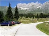
A) From Kranjska Gora over the border crossing Rateče we drive to Trbiž / Tarvisio. In Trbiž we continue left in the direction of Bovec and we follow the road to the crossroad near Rabeljsko jezero. Here we continue right in the direction of Nevejski preval (Na Žlebeh) / Sella Nevea. When the road already starts descending towards Reklanska dolina, in a sharp left turn a narrow and steep road towards Montaževa visoka planota / Altopiano del Montasio branches off to the right (by the crossroad there are signs in Italian language). We follow this road to a large marked parking lot, which is situated a few hundred meters before the cheese cottage Pecol (further driving is forbidden).
B) From Bovec we drive to the border crossing Predel, from which we descend to the Italian side. Just a little after Rabeljsko jezero we come to a crossroad, where we continue left in the direction of Nevejski preval (Na Žlebeh) / Sella Nevea. When the road already starts descending towards Reklanska dolina, in a sharp left turn a narrow and steep road towards Montaževa visoka planota / Altopiano del Montasio branches off to the right (by the crossroad there are signs in Italian language). We follow this road to a large marked parking lot, which is situated a few hundred meters before the cheese cottage Pecol (further driving is forbidden).
Route description:
From the parking lot on the mountain pasture Pecol we head onto a narrow road which leads right towards the mountain hut Rifugio di Brazza. Soon signs direct us left onto a footpath, on which through meadows in good 15 minutes we reach the hut. At the crossroad, which is only a few dozen meters above the hut, we take the left path, which leads towards the saddle Forca dei Disteis (2201m), the right path leads to Špik Hude police (2420m). From the crossroad we first descend a few meters and then in a gentle ascent we cross meadows below the walls of Montaž and if we are lucky we can also observe Alpine marmots, of which there are quite a few around here. Soon from our left side the direct path from the mountain pasture Pecol joins, which is a few minutes shorter than this one past the hut. Here the path already ascends somewhat more steeply and soon brings us to the aforementioned saddle where there are usually many ibex. To the saddle we need from the starting point just under two hours. At the saddle the path turns right over scree and soon we come again to a crossroad. The left less visited and somewhat more demanding path leads towards the bivouac Suringar (2430m). We take the right path, which continues crossing scree and brings us to the memorial plaques, where we enter the rocky part of the path. Here the path becomes more demanding, some easy climbing is required, steel cables also assist us. The path then becomes somewhat less steep and in the left turn brings us to a crossroad.
We head right, where the Leva path begins, left leads the path over Pipan's ladder to Montaž. From the crossroad the path soon brings us to precipitous ledges along which we cross the slope below Špik nad Plazom towards the east. There also follow some short steep ascents along the steel cable, some pegs also assist us. Further on the path continues along ledges crossing precipitous slopes, then it starts to descend somewhat more steeply into the Škrbina nad Cijanerico / Forca del Palone. On this section we descend almost vertically several times along the steel cable and pegs.
From the notch we continue towards the east and begin to ascend steeply along the steel cable. The path then brings us to an approximately 10m high ladder, which on the lower part is not attached, so the ladder swings somewhat. Above the ladder follows a less demanding ascent along the steel cable and then also a crossing over a somewhat more grassy slope, which brings us to a junction. Here the Leva path ends and to the summit of Špik Hude police there follow a few minutes of easy walking on the summit slope of the mountain.

Photos:
 1
1 2
2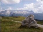 3
3 4
4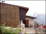 5
5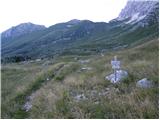 6
6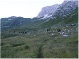 7
7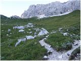 8
8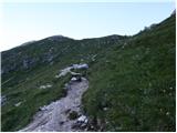 9
9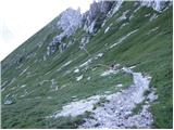 10
10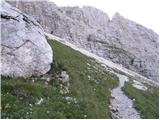 11
11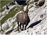 12
12 13
13 14
14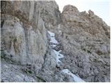 15
15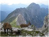 16
16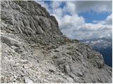 17
17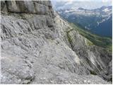 18
18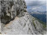 19
19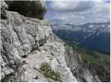 20
20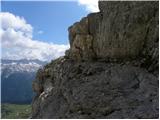 21
21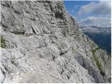 22
22 23
23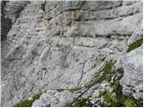 24
24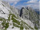 25
25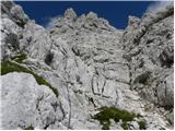 26
26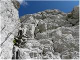 27
27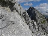 28
28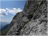 29
29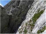 30
30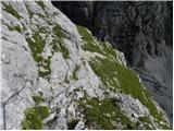 31
31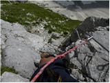 32
32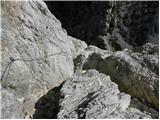 33
33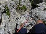 34
34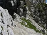 35
35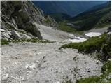 36
36 37
37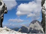 38
38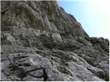 39
39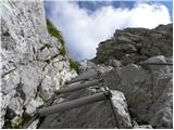 40
40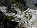 41
41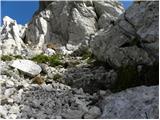 42
42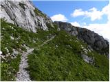 43
43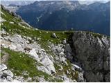 44
44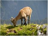 45
45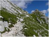 46
46 47
47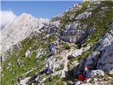 48
48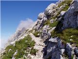 49
49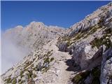 50
50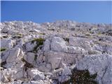 51
51 52
52
Discussion about the trip Pecol - Cima di Terrarossa (Leva)
|
| Matjaz_656. 08. 2012 |
some photos from the Špik Hude police path - left ferrata - Findenegg glacier - Montaž 
|
|
|
|
| rogoza25. 06. 2013 |
And does anyone know if there are still any snowfields? Thanks
|
|
|
|
| kitina11. 08. 2013 |
I was there on Thursday 8.8.2013. The path is normally passable! Lp.
|
|
|
|
| jvali14. 08. 2013 |
matjaž 65: exceptional photos.
|
|
|
|
| julya15. 09. 2013 |
Yesterday finally on the Leva path. A little snow on some ledges, cold in the notch, but warm on the slope so we felt like it was St. Martin's day. We didn't muster enough will for the planned Špik nad Plazom, in the end we "excused" ourselves that we'll go up when there's no snow on the ledges. Ceria-Merlone will probably remain for next year.
|
|
|
|
| nightclimb19. 09. 2013 |
Video Cima di Terrarossa via Leva
|
|
|
|
| ninooos29. 07. 2014 |
Has anyone been on this path recently? I'm interested if there's still snow on the path and how the fixed cables have withstood the winter?
Thanks, best regards
|
|
|
|
| spela.jarc6. 10. 2014 |
Does anyone know the conditions on the path? thanks
|
|
|
|
| maregol25. 06. 2019 |
The path is completely dry.
|
|
|
|
| danielenidoma25. 06. 2019 |
Oo super, this Left one too then
Thanks for the info!
|
|
|
|
| bumbi26. 06. 2019 |
The Left path is probably quite different. Last July I had to cross three snowfields. Probably similar this year.
|
|
|
|
| Razbojnik30. 06. 2019 |
Does anyone know Levo? In different sources I found different difficulty ratings, somewhere B/C on the Austrian scale, elsewhere it's supposed to approach C/D.
Which direction do you think makes more sense, east-west or vice versa?
|
|
|
|
| danielenidoma30. 06. 2019 |
We were there today! I don't know about ratings, so .. but the path is dry, really very beautiful, airy and panoramic. We went in the direction towards Špik hude police. There are some descents, maybe it would be easier the other way, really, but it's well secured, so really great.
Good luck!
|
|
|
|
| panoramik30. 06. 2019 |
The direction to the west is better, then a hop to Montaž and that's it.
|
|
|
|
| danielenidoma1. 07. 2019 |
Also an option of course Montaz never disappoints today a real procession on Pipanu.
Good luck!
|
|
|
|
| danielenidoma1. 07. 2019 |
Also an option of course Montaz never disappoints today a real procession on Pipanu.
Good luck!
|
|
|
|
| kozorog9429. 07. 2020 |
Hello, how demanding is this path compared to the path to Montaž over Pipan ladder? thanks!
|
|
|
|
| mirank29. 07. 2020 |
Approximately as demanding as the section of the path to Montaž to sedla Disteis
|
|
|
|
| mirank29. 07. 2020 |
Oops sorry; the Leva path is something else. Otherwise no major ups and downs on the traverse, but locally exposed well-protected path type A. Goitan or Ceria-Merlone, of which it is actually the extension. Helmet mandatory, full via ferrata kit too.
|
|
|
|
| mizakaši22. 07. 2021 22:26:49 |
Yesterday with my dear one I was in these beautiful parts. Since we did Montaž via Pipanovo last year, we decided to climb the promised Left Path this year. We started in the opposite direction. We began below Pipanovo ladder and headed towards Špik. The path is excellently secured with impeccable protections. Technically not demanding but quite airy. Not for the dizzy. After descending to the notch, there's a short ascent along the cable and a short ladder, which is perhaps even slightly overhanging for the first couple of meters. A few more turns and we're at the top with wonderful views from Viša all the way to Montaž and further to Strme peči. No snow on the path anymore. For the return, beer at the hut and then descent back to the valley on the newly asphalted road. As a curiosity, I can say that a young ibex followed us the whole way. All the way to Špik. Whether that's their habit, I don't know.
|
|
|
|
| bagi19. 09. 2022 12:40:55 |
Regarding the information ... from Špik above Hude police, there is no notice about the closure of the Leva path. You only encounter this sign after walking the path at the exit towards Montaža. If the path is really supposed to be closed, it should apply to both directions. As for the path's condition, I can only say that it was already in much worse shape.
|
|
|
|
| Kafetarca1. 09. 2023 08:27:31 |
Has anyone been on this trail this year, what's the condition of the protections now? On some Italian site I read in a comment that the via ferrata has been closed since July due to a landslide, have they perhaps fixed it in the meantime?
|
|
|
|
| turbo1. 09. 2023 09:03:26 |
|
|
|
|
| Janez Seliškar1. 09. 2023 09:16:38 |
Italians are also slow to update information.
The path is normally passable. Post from 23.08.2023 on FB.
|
|
|
|
| mirank1. 09. 2023 11:26:50 |
It wasn't much missing before either, a couple of pulled out or loosened pitons. They close it to protect themselves, because not everything is according to the rules
|
|
|
|
| Hribovc9116. 09. 2023 12:43:04 |
16.9.2023 still 5-6 pulled pegs but on non-critical spots.
|
|
|
|
| Zlatiprinašalec1. 07. 2024 10:11:02 |
Does anyone perhaps know how the snow is on the path?
|
|
|
|
| ton24. 07. 2024 09:48:35 |
Hello, I'm interested in the condition on ferrata Leva?
|
|
|
|
| mirank24. 07. 2024 10:46:48 |
About a week ago, I wrote under the Montaž topic that they replaced the entire safety gear
|
|
|
To post a comment you must log in:
If you do not yet have a username, you must first
register.