Nevejski preval - Viš/Jof Fuart
Starting point: Nevejski preval (1170 m)
| Latitude/Longitude: | 46,4147°N 13,4755°E |
| |
Walking time: 5 h
Difficulty: difficult marked way
Elevation gain: 1496 m
Elevation difference along the route: 1700 m
Map: Julijske Alpe - zahodni del 1:50.000
Recommended equipment (summer): helmet, self belay set
Recommended equipment (winter): helmet, self belay set, ice axe, crampons
Views: 57.634
 | 2 people like this post |
Access to starting point:
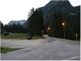
From Kranjska Gora via the Rateče border crossing we drive to Trbiž / Tarvisio. In Trbiž we continue left in the direction of Bovec and follow the road to the junction near Rabelj Lake. Here we continue right in the direction of Nevejski preval / Sella Nevea. We follow this road, which is mostly ascending, to the saddle, where on the right side of the road we will notice a smaller ski slope. We park on the macadam parking lot below the ski slope.
From Bovec we drive to the Predel border crossing, from which we descend to the Italian side. Just a little after Rabelj Lake we come to the junction, where we continue left in the direction of Nevejski preval / Sella Nevea. Further, follow the above description.
Route description:
From the parking lot we continue on the asphalt road (on the left side of the ski slope - ski track on the northern side of the main road), which branches off from the main road at the saddle. By the road we will also notice a sign marking path 625 towards the Corsi hut and a detailed map. In a left turn we leave the road and head right onto a poorly trodden path that brings us to a macadam road ascending on the right side of the ski slope. For some time we then ascend on the road, then the markers direct us left into the forest. After a short ascent we come to a junction, where we continue right on path 625, left branches the path towards the Pecol pasture and Brazza hut. The path then continues ascending through the forest and crosses a mountain road several times, bringing us to a junction where another path towards the Brazza hut branches left. The path then turns right and begins crossing slopes towards the east. Soon we also emerge from the forest onto grassy slopes and an ascent follows towards the saddle Passo degli Scalini (2022m), where there are usually many ibex. From the saddle a short descent follows, bringing us to a junction where left branches the path towards the saddle Lavinal dell'Orso (2138m). At the junction we continue right and soon path 628 joins us from the right, leading past the lower station of the cargo cable car. A relatively wide path then leads us below overhanging walls and past some military dugouts from the First World War. To the Corsi hut only a short descent on grassy terrain follows.
From the hut we continue northwards, where we begin ascending partly grassy and partly rocky terrain. The path then brings us to a junction, where we turn left onto path 627, right leads path 625 towards Krniška škrbina (Ital. Forcella del Vallone) and further towards bivouac Gorizia. After a short ascent we come again to a junction, where we go left again (direction Jof Fuart), right leads path 627 towards Trbiška škrbinica (Forcella di Riofreddo). The path then turns slightly left and brings us to the start of a somewhat more demanding section. Here the path turns right upwards and some easy scrambling on rock is also required. The path then turns slightly right and brings us to another somewhat more difficult section. Here the path turns left upwards and begins ascending along a steel cable. A somewhat low passage through a window follows and then again ascent along the steel cable. The path then brings us to a junction, where path Anita Goitan joins us from the right from precipitous ledges. After a short ascent we come again to a junction where we go right, left branches path Anita Goitan. A moderately steep ascent follows on rocky and somewhat scree terrain. Just below the summit the northeast path Gola Nordest also joins us from the right. From here only a short ascent to the very panoramic summit follows.

Photos:
 1
1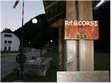 2
2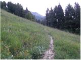 3
3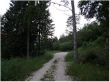 4
4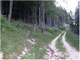 5
5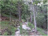 6
6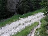 7
7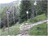 8
8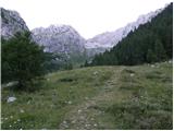 9
9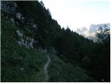 10
10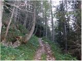 11
11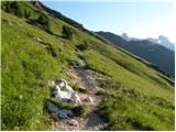 12
12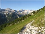 13
13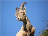 14
14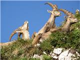 15
15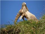 16
16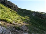 17
17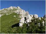 18
18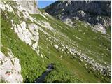 19
19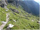 20
20 21
21 22
22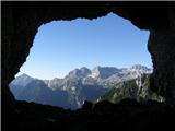 23
23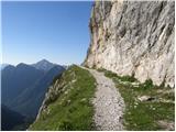 24
24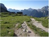 25
25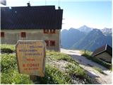 26
26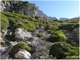 27
27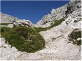 28
28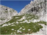 29
29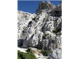 30
30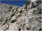 31
31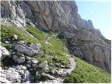 32
32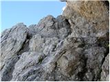 33
33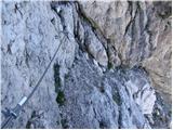 34
34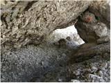 35
35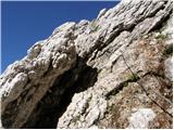 36
36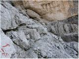 37
37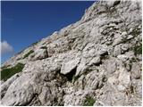 38
38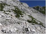 39
39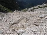 40
40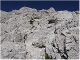 41
41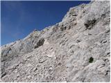 42
42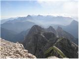 43
43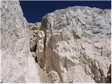 44
44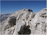 45
45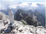 46
46 47
47
Discussion about the trip Nevejski preval - Viš/Jof Fuart
|
| spominčica20. 08. 2008 |
I won't write an opinion about the trip because I haven't been there yet, but I'm very interested in who the authors of the photos are. Hribi.net has fantastic galleries. All praise to the authors. Keep it up!
|
|
|
|
| triglavski20. 08. 2008 |
Left, then right, then at the junction left, then right!? It would be hard for anyone to find their way from this description. The ski slope, which usually never operates, is on the right if coming from Rablja direction, and we also go right along the ski slope, higher up we reach the Krni dol pasture, which is an important hub and it's not just left and right, but also straight up towards Forca de la Val and towards the top of Krni dol. The notches also have nice Slovenian names, like Forcella Lavinal del Orso is Škrbina Prednje špranje. Later from Koča Corsi onwards, there is a path left to Škrbina Zadnje špranje also called Mojzesova škrbina (Forcella Mozes on Viš, usually described as descent because it's easier). In short, a very poor description of the path to Viš.
|
|
|
|
| krasovc27. 06. 2011 |
45-year-old Gorizan David Cassani died during a demanding ascent to the 2666 m high Viš (Jof di Fuart) in the Tarvisio Alps. According to rescuers so far, Cassani was ascending towards Corsi hut with a friend, but took the wrong path, slipped and plunged into the abyss.
http://www.primorski.it/stories/alpejadran/188432_usodni_vzpon/
|
|
|
|
| jedriličar15. 11. 2012 |
Does anyone know the status of the winter room at rif. Corsi? Maybe I'll go up this weekend. Is it normally open or do you need to get a key somewhere?
Thanks in advance for the answers....
|
|
|
|
| IgorZlodej15. 11. 2012 |
Koča Corsi has a winter bivouac that stands behind the hut. Like all other bivouacs, it is also open for possible emergency shelter in case of need.
|
|
|
|
| VanSims6. 08. 2013 |
As Igor already noted (when he was still Triglav's  ), the description is indeed a bit awkward. On the terrain, the path is well marked, but the junctions are poorly signposted. ), the description is indeed a bit awkward. On the terrain, the path is well marked, but the junctions are poorly signposted.
So: from Corsi I went straight ahead. First, a path branches off to the left towards Škrbina prednje špranje and towards Viška planina. Here straight ahead! After just a minute or two, there is another fork. The arrow with 'Jof Fuart' painted on the rock just before the fork can be easily overlooked. Here now to the left. Then I (together with three similarly wandering Italians) didn't see any junction anymore until the moment the path turned left towards Mojzesova škrbina. There you have to go right where we don't see markings - the junction is simply not signposted! Immediately start looking to the left and after a few dozen seconds we spot a red arrow on the rock for continuation. Here begins somewhere the most difficult free-climbing section. Straight ahead there are also markings but the path is obviously not the right one (I assume it's the path towards Trbiška škrbinica).
So the author obviously forgot the first fork towards Škrbina prednje špranje and the fork towards Mojzesova škrbina (as Igor mentioned).
After a bit of free climbing, walking and ascending through chimneys, we reach a junction (first junction with A. Goitan), which is again poorly signposted. Right 'A. Goitan', left 'Mosé'. No trace of 'Jof Fuart'... There we go left as the description says. At the next junction (second junction with A. Goitan) then right, the path towards Mojzes goes left there.
|
|
|
|
| lubadar6. 08. 2013 |
I agree with the predecessors, I also got it wrong last year. I wanted to take the normal route, but I strayed towards Mojzesova škrbina, so I just continued to Viš/Jof Fuart from there.
|
|
|
|
| AnzeKozjek19. 05. 2014 |
Nice greeting, I'm interested if this path to Viš (marked as difficult) is very vertiginous?
|
|
|
|
| VanSims11. 08. 2014 |
This year I finally saw where the junction is when I came from the direction of Krniška škrbina. The path splits right after Koča Corsi into the one towards Mojzesova škrbina and the one to Viš, Krniška Škrbinica and Anita Goitan. This junction is poorly marked or it's not clear that you go right to Viš, otherwise the description above matches perfectly.
If we already head towards Mojzes, we can still reach the normal route as I described above, so where the markers go left to Mojzes, we go right and then where we spot the red arrow on the rock to the left, the 'easy climbing on rock' as written in the description begins.
Anyway, even if we go left to Mojzes, we still reach Viš. From Mojzesova škrbina, go left to Koštrunove špice, right to Viš through the so-called 'Mojzesov kuloar'. This path, although formally part of the famous 'Anita Goitan', is not much harder than the normal route. The only tricky part is the last pitch before the path becomes just a walking path. It's a short steep and narrow passage between two rocks (a bit awkward for heavier people and those with large backpacks). Then after about half an hour of walking on practically flat terrain, we join the normal route.
|
|
|
|
| jurčk_18. 08. 2014 |
Hi, good day.... I'm wondering about the conditions in this direction to Viš? Maybe some larger snow patches?
|
|
|
|
| IgorZlodej18. 08. 2014 |
@VansSims, 'Mojzesov kuloar' will need to turn into Špranjo once
|
|
|
|
| VanSims18. 08. 2014 |
No snow on approaches from Koča Corsi, neither on normal route nor through Mojzesova špranja (Igor, thanks for warning, I've obviously read too many foreign sites, this path not described here).
According to information from Koča Corsi, no snow on other (harder) side of Anita Goitan nor on Ceria Merlone which leads otherwise to Poljske špice.
|
|
|
|
| vavtora23. 09. 2014 |
hi does anyone know if there's any snow on Viš? thanks for the answer!
|
|
|
|
| vavtora24. 09. 2014 |
many thanks for the reply, good luck!
|
|
|
|
| Janiel745. 06. 2015 |
Has anyone perhaps already gone to those parts this year?
Given the weather conditions, I hope it will be snow-free soon...
Does anyone have any information, especially about snow?
P.S. (and please don't tell me to take ice axe and crampons, because I'm asking if it's snow-free)
Thanks for the info.
|
|
|
|
| Hawk13. 07. 2015 |
Before heading to Viš via this classic, take time to study the route from Koča Corsi onwards.
There are namely no really useful signs indicating which path goes where, and this Saturday there were quite a few wandering and confused hikers looking for this route.
In short, when you reach Koča Corsi, Viš is straight up from the hut. You have to reach the wall where there is a painted arrow upwards (picture 30), which is quite hard to spot.
From there on, you can somehow follow the description given on this page and the markers on the spot all the way to the summit.
|
|
|
|
| gams113. 07. 2015 |
Poor and faded markings are a classic in the ITA Julian Alps, except perhaps some minor renewals around the hut (we know why!?), and the same under Montaž on Planina Pecol or on the ITA side of Kanin.
|
|
|
|
| Otto15. 07. 2015 |
On Saturday morning there wasn't much rush to Viš, but there are great views and the path is also OK.
Regarding orientation, here's my comment. If you read how the path looks on the forum or in some guidebook, you shouldn't have major orientation problems as the path branches right twice to the wall and it's always marked where it goes and if it's not your direction you just keep left (except right above the hut, where a path goes left without a sign, there you keep right), and once you're at the wall there's basically only one path; once the Anita G. path joins from the right and once the path to Mojzes (Mose) branches left.
But you have to be careful not to gain extra elevation. I admit I was a bit afraid I'd get lost too based on the comments, but I managed well. So no fear and a bit of attention and it's fine.
|
|
|
|
| Shime7. 09. 2015 |
A month ago we set off for Viš, at the last moment we abandoned A. Goitan and took the 'usual' path. My mistake was not reading the comments carefully, so we ended up at Škrbina zadnje Špranje thinking we were on the usual path. 
Anyway, we reached Škrbina zadnje Špranje and there joined the A. Goitan path towards the east. The path descends a bit back along the ledge and after a few meters turns sharply upwards to the left, into the rock, on new fixed ropes (recommend a full via ferrata kit!). We climb up the ropes for a few minutes and then the path becomes easier. We continue following the markers to the summit.
I didn't find a description of the path from that side, and unfortunately I have no photos to share, but for information, if someone takes this route.
Wishing you safe steps! 
|
|
|
|
| borlepadrino27. 12. 2015 |
Yesterday on Viš there was an exceptional and indescribable view. Such a wonder I haven't seen yet and I think I won't. The path is dry. Need to be careful a bit, helmet not superfluous. Ibex and chamois were posing diligently.
|
|
|
|
| IgorZlodej27. 12. 2015 |
It's been like this for two months already day after day, ibex 
|
|
|
|
| redbull27. 12. 2015 |
I'm no longer counting the weekends with nice weather
|
|
|
|
| masker28. 08. 2016 |
Yesterday, Saturday, August 27th, ascended Viš with friends. Weather conditions almost ideal. Chamois kept us company on ascent. Summit view superb, not a cloud in sky. Ascent via usual path from Rifugio Corsi steeply up classic. For descent chose Mojzesova škrbina variant, which proved successful. Been to Jof Fuart summit several times before, last exactly ten years ago in autumn once in September. This time Viš again offered unique mountaineering pleasures only such mountain trips provide.
|
|
|
|
| franjo662. 09. 2016 |
Is a via ferrata set for self-belaying necessary!
|
|
|
|
| VanSims2. 09. 2016 |
Very dependent on your mountaineering experience.
Generally, for a somewhat experienced hiker, no. But if you would use it for example for Turska gora from Kamniško sedlo or say for Planika-Mali Triglav or say to Planjava or e.g. Slovenian to Prisojnik and Italian normal route to Mangart,... then yes, otherwise no.
Helmet is recommended anyway, Italian Julijci are more crumbly than ours.
|
|
|
|
| J.P.17. 07. 2022 21:40:53 |
Today the Corsi hut was closed - those counting on it being open, check beforehand. The path is longer but definitely worth it as the scenery along the way is exceptionally picturesque. Be more attentive to the junctions above the hut if you'd rather go more directly to the summit and not over Mose. LP
|
|
|
|
| mirank18. 07. 2022 18:00:04 |
Take note that the hut has been closed for a couple of years...
|
|
|
|
| J.P.18. 07. 2022 20:33:34 |
|
|
|
|
| Koleraba19. 07. 2022 09:58:48 |
It would make sense to note in the trail descriptions that the hut is closed, so no one else relies on provisions there.
|
|
|
|
| mirank19. 07. 2022 13:56:18 |
Under current conditions, this has been described long ago. This access from the saddle in Žlebeh is a bit unusual, as evidenced by the dates of the records or comments.
|
|
|
To post a comment you must log in:
If you do not yet have a username, you must first
register.