NC Planica - Srednja Ponca / Ponza di Mezze
Starting point: NC Planica (931 m)
| Latitude/Longitude: | 46,476°N 13,7241°E |
| |
Walking time: 4 h
Difficulty: difficult marked way
Elevation gain: 1297 m
Elevation difference along the route: 1305 m
Map: Julijske Alpe - zahodni del 1:50.000
Recommended equipment (summer): helmet
Recommended equipment (winter): helmet, ice axe, crampons
Views: 34.767
 | 2 people like this post |
Access to starting point:
a) First we drive to Kranjska Gora, then continue driving towards Rateče. When we arrive at the roundabout near Rateče, we take the exit in the direction of Planica. This is followed by some ascent and we arrive at the large parking lot next to the Nordic Centre Planica, where we park in the paid parking lot. The price for passenger cars is 2.5 EUR / day (March 2019).
b) Via the Rateče border crossing we drive into Slovenia, then we soon turn right towards Planica. This is followed by some ascent and we arrive at the large parking lot next to the Nordic Centre Planica, where we park in the paid parking lot. The price for passenger cars is 2.5 EUR / day (March 2019).
Route description:
From Planica we continue along the gravel road towards Dom v Tamarju. Before the road enters the forest, it splits into two parts. We continue on the slightly right road in the direction of the footpath towards Tamar (slightly left is the drivable road, which is closed to public traffic).
The path ahead leads us along the road, which passes the last parking lot of NC Planica, enters the forest and which in winter is converted into a cross-country ski track. This is followed by an ascent along a gentle road that mostly runs through the forest. When the path leaves the forest, there are viewpoints along the path with signs indicating what can be seen. Higher up, the forest thins out or we leave it for a while, so beautiful views of the mountains rising above Planica and Tamar open up. When we are already quite close to Dom v Tamarju, a wonderful view of Jalovec opens up and the path splits.
We continue slightly left (slightly right is the source of the Nadiža) and a few minutes later we join the drivable road, along which we pass a small chapel and arrive at the Planinski dom v Tamarju.
We continue along the marked mountain path in the direction of Jalovec and Ponce (left Slemenova špica). The path ahead leads us through the forest, which quickly brings us to the next junction, where the path to Ponce branches off to the right. We continue in the mentioned direction (straight ahead Jalovec and Kotovo sedlo), or following the signs for Srednja Ponca and Visoka Ponca.
The path ahead takes us out of the forest and begins to ascend to the right of a smaller stream. Higher up, the path turns right again and begins to ascend through dwarf pines on a rather steep slope. The path then turns somewhat to the left and takes us past a small cave back into the forest through which we ascend for quite some time. After several steep ascents through the forest the path takes us out of the forest and brings us to the first steel cables on the path. Here the path turns right and ascends steeply. The steepness soon eases and a traverse of the slopes towards the north follows. Towards the end the slopes become quite steep and we are assisted by some steel cables. The path then turns left and begins to ascend somewhat more steeply again all the way to the main ridge of the Ponce. On the ridge we then turn right (left Zadnja Ponca) and only a few meters of ascent remain to the summit of Srednja Ponca.
Planica - Dom v Tamarju 0:45, Dom v Tamarju - Srednja Ponca 3:15.

Photos:
 1
1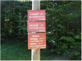 2
2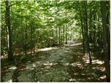 3
3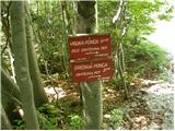 4
4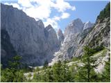 5
5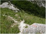 6
6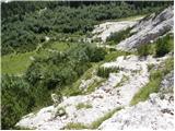 7
7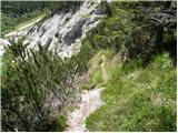 8
8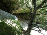 9
9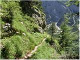 10
10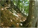 11
11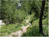 12
12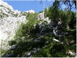 13
13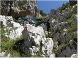 14
14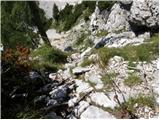 15
15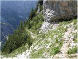 16
16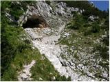 17
17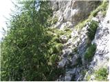 18
18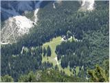 19
19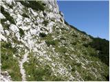 20
20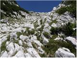 21
21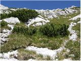 22
22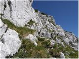 23
23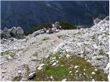 24
24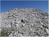 25
25 26
26
Discussion about the trip NC Planica - Srednja Ponca / Ponza di Mezze
|
| nisa23. 06. 2010 |
On Friday 18.6. I was at the summit. The path is initially poorer improving with altitude. No special features no snow either. Views from the top are fantastic. It may be worth mentioning that the path is very steep especially noticeable on the descent to the valley.
Best regards!
|
|
|
|
| VanSims2. 10. 2011 |
Yes, the path through the forest is really steep (poles are very useful on descent). When we exit the forest (raspberry patch on the left), we still have some wire ropes (the first one the hardest - two pegs pulled out!) and here and there some easier rocky steps. Crossing the northern slopes is somewhat exposed in places.
|
|
|
|
| bistri22. 09. 2012 |
TNP closed the road to the Dom in Tamar. Why?
Probably so management has free parking for two-ton TNP jeeps, others just walk.
We hikers don't like this approach, it shows all the arrogance and pomposity of TNP managers who claim common property for themselves. 
|
|
|
|
| Becar22. 09. 2012 |
I'm generally against excessive traffic in the Julian Alps area, but here I agree with bistrim. Where there's been a nice road to a hut in the valley for years, why close it? Then close Vršič pass too, deeper in TNP heart, much higher than Tamar and 1000x busier than Planica and Tamar. Or Logarska dolina example. Similar view for path extension from Kamniška Bistrica, where closure is senseless and causes only ill will.
|
|
|
|
| Becar22. 09. 2012 |
Or why, for example, don't they then close the road to Mangartsko sedlo? So they can cash in?
|
|
|
|
| jax22. 09. 2012 |
Enough has been said about this, but I agree with the above commenters anyway. But I doubt anything will change ...
We could try a guerrilla action that came to mind regarding this issue: drive to Tamar, remove the license plates from the car, put them in the trunk and go to the mountains. Then let them punish you if they can ...
|
|
|
|
| pikica122. 09. 2012 |
Of course they can. Before you get back to the car they can put handcuffs on the car. What will you do then you'll cry to be able to go home. you'll cry to be able to go home.
|
|
|
|
| jax22. 09. 2012 |
Wait, now according to the new rules they handcuff in Tamar? We've come far, here in the heart of the mountains, away from the ills of civilization ...
|
|
|
|
| pikica122. 09. 2012 |
Yeah no. But if they took the plates down from the car they could also mutter something to charge you that fine. I don't believe they'd leave you in peace if you did that with the plates. The bill could be even bigger
jax try it and report
|
|
|
|
| urbancek23. 09. 2012 |
I think you can't do that extra good half hour on foot...
|
|
|
|
| potočan23. 09. 2012 |
Yeah, whoever can't walk to Tamar should just stay home, let mommy "protect" them. Further comments are completely unnecessary.
|
|
|
|
| turbo23. 09. 2012 |
By bike from Planica to Tamar is legal and legitimate
And entirely in the sporting spirit 
|
|
|
|
| pikica123. 09. 2012 |
At least once a week I measure the road to Tamar by bike or on foot. Sometimes I come across a wedding there in front of the chapel in Tamar. Then there are as many cars up there as you like If they decide to get married in the heart of the mountains, they should walk that really short road on foot. After all, something worse than those couple of kilometers of gravel awaits them on the common path  If the sign is there, it applies to everyone, the sign says who can drive up that road by car. If the sign is there, it applies to everyone, the sign says who can drive up that road by car.
|
|
|
|
| metod23. 09. 2012 |
I'm a real mountaineer! Hours and hours I hike in the hills, but half an hour in the valley to the starting point I can't be bothered. And if they close the road, I spit and thrash everything around.
|
|
|
|
| SunBurned3. 08. 2013 |
A couple of impressions from today's hellishly hot path. The lower part (1 hour from Tamar) is so steep that without poles on the return (downhill) it would be quite impassable in places. Additionally, it's dangerously exposed in some spots. Caution!
The middle part with cables is well secured, although a bolt is missing here and there.
The upper part requires quite a bit of attention, especially on the return, because it's not abundantly marked. It's not exactly precipitous, some "artistic freedom" is possible.
The views are wonderful, the feeling at the top excellent. Just too hot. The goal of the hike was actually Visoka P., but it didn't work out with the amount of water and energy ran out too. Next time.
|
|
|
|
| p.pikander6. 08. 2013 |
I join the previous comment; I haven't seen such steep paths for a long time.
Missing pegs are not a problem yet, the scree towards the end of the middle section might be more dangerous, where the ground happily crumbles underfoot.
The view is beautiful, that's for sure.
|
|
|
|
| abes13. 06. 2017 |
Has anyone perhaps been on this route in the past few days, conditions? best regards
|
|
|
|
| Julijec13. 06. 2017 |
Two weeks ago, only some negligible snow
|
|
|
|
| abes15. 06. 2017 |
Thanks. best regards
|
|
|
|
| Julijec15. 06. 2017 |
Aha, on the Italian side of Zadnja Ponca there were also some smaller snow patches, which didn't pose a problem either, because the snow was wet.
If you extend it have a nice tour
|
|
|
|
| garmont16. 07. 2017 |
The path maintainer PD Medvode should take care of renewing the markings on the entire path. 
Especially in the summit, more rocky part, it's noticeable, or not even, that the markers were last active here quite a few years ago. 
|
|
|
|
| B216. 07. 2017 |
@garmont, the maintainer of the path to Poncas hasn't been PD Medvode for a long time but PZS (see "Planinske poti PZS")...
|
|
|
|
| garmont16. 07. 2017 |
I rather looked at the direction sign, actually two, which are located behind the Dom v Tamarju hut.
You know, quarrels between PD and PZS have never been beneficial for hikers and the trail maintenance in this area is just the result of that.
|
|
|
|
| Grenaleva18. 09. 2018 |
Has anyone walked this path in the last few days? How are the markings now or what are the conditions on the path? Thanks
|
|
|
|
| noname25. 10. 2019 |
Went up on 22.10.. Markings still very poor. Caution in the forest is not superfluous at all, because there is a lot of leaves and it slips. Otherwise as the predecessors wrote.
|
|
|
|
| ssimon9. 10. 2020 |
Hello, does anyone have information on the conditions on Srednja Rateška ponca? Thanks for the reply, best regards.
|
|
|
|
| navdušena22. 08. 2022 08:19:45 |
Hello,
has anyone been to the Poncas this year? What's the path like to Srednja Ponca and then further on?
|
|
|
|
| zdejan21. 08. 2023 22:10:24 |
We were up there on 19.8.2023. Markings are very faded, need to be very careful. Also need to be careful at the entry into the steep section about 5 min from the hut. The path leads into the gully and you easily miss the left junction. If you continue up the gully, you can get into trouble. It would be worth putting up a signpost there.
|
|
|
|
| tango10. 10. 2023 19:24:15 |
Today my wife and I climbed to the summit. I admit, the steepness surprised us, as it's practically a solid steep ascent all the way, flattening a bit at the exit from the forest and before the final summit push. The trail through the forest is clearly visible, but that will change a lot with falling leaves
The lower part (between pics 8 and 9) can be quite slippery when wet, especially on descent, the summit part above the forest line sometimes requires "a hawk's eye" to find the marks, but the passages are fairly logical, so even if you miss one there's no problem, but they can be in poor visibility-fog, but then anyway I believe no one would choose such a day for their first ascent. The entire trail up and down requires caution. After finishing, it's just right to walk to Planica.
|
|
|
|
| cen15. 08. 2024 20:43:45 |
Those 45min from Planica to the hut are just right to warm up before the entrance where it immediately raises your pulse and doesn't let go until the top.. I don't remember such constant steepness on any other path.
Especially the entrance and the first hour of ascent through the forest are in the worst condition, everything very overgrown, many fallen trees, in places eroded by water.
The markers have really faded and you have to look around here and there, but you can't really get lost.
Highly recommend poles.
|
|
|
|
| hike_mare2. 07. 2025 10:22:08 |
Hey, I was up there on 14.6.. Nothing new compared to what previous hikers described. When we start the ascent, the steepness is your best friend all the way to the top (poles recommended)  . .
The forest part of the ascent is not far from turning from a marked path into pathless terrain . The markers are very faded (if noticed at all) and be careful in the wire rope section (picture 14), where two pegs are pulled out.
If you're looking for peace from people, you'll surely find it on this path and summit
|
|
|
|
| user031014. 08. 2025 16:41:13 |
I plan to go on Saturday, so the path is trodden but the markers are no longer visible. Is the path generally safe and is only that part at the cables more exposed?
|
|
|
|
| Hrobson15. 08. 2025 09:13:37 |
I was up there on 14.8.. The path is trodden and despite faded markers nicely followable. Those two pulled-out pegs don't pose problems. Rather I would point out that between pictures 7 and 9 on descent it's very slippery and without poles I don't know how it would go… As for exposure, the path is exposed on short sections where it crosses slopes to the right, one part of the crossing has a cable picture no. 18. As far as I'm concerned nice path but very steep from Tamar onwards doesn't let up for a minute.
|
|
|
|
| user031015. 08. 2025 10:29:11 |
OK thanks for the info and bravo for the ascent
|
|
|
To post a comment you must log in:
If you do not yet have a username, you must first
register.