NC Planica - Jalovec (via Jalovška škrbina)
Starting point: NC Planica (1108 m)
| Latitude/Longitude: | 46,476°N 13,7241°E |
| |
Route name: via Jalovška škrbina
Walking time: 6 h 30 min
Difficulty: very difficult marked way
Elevation gain: 1537 m
Elevation difference along the route: 1620 m
Map: TNP 1:50.000
Recommended equipment (summer): helmet, self belay set
Recommended equipment (winter): helmet, self belay set, ice axe, crampons
Views: 62.194
 | 11 people like this post |
Access to starting point:
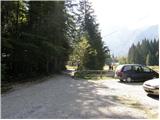
a) First we drive to Kranjska Gora, then continue driving towards Rateče. When we reach the roundabout near Rateče, we take the exit towards Planica. This is followed by some ascent and we arrive at the large parking lot next to the Nordic Center Planica, where we park in the paid parking lot. The price for passenger cars is 2.5 euros / day (March 2019).
b) Through the Rateče border crossing we drive into Slovenia, then we soon turn right towards Planica. This is followed by some ascent and we arrive at the large parking lot next to the Nordic Center Planica, where we park in the paid parking lot. The price for passenger cars is 2.5 euros / day (March 2019).
Route description:
The described path is closed until further notice due to damaged safety equipment on the section below Jalovška škrbina (information from September 2023).
From Planica we continue along the gravel road towards Dom v Tamarju, before the road enters the forest it splits into two parts. We continue along the slightly right road in the direction of the footpath towards Tamar (slightly left is the drivable road, which is closed to public traffic).
The path ahead leads us along the road, which passes the last parking lot of NC Planica, enters the forest and in winter is converted into a cross-country ski track. This is followed by an ascent along a gentle road, which mostly runs through the forest, when the path leaves the forest, there are viewing scopes with signs of what can be seen along the path. Higher up, the forest thins out several times or we leave it for some time, so that beautiful views open up to the mountains that rise above Planica and Tamar. When we get quite close to Dom v Tamarju, a wonderful view of Jalovec opens up to us, and the path branches.
We continue slightly left (slightly right the spring of Nadiža) and a few minutes later we join the drivable road, along it we pass a small chapel and arrive at the Planinski dom v Tamarju.
We continue along the marked mountain path in the direction of Jalovec and Ponce (left Slemenova špica). The path ahead leads us through the forest and quickly brings us to the next junction, where the path to Ponce branches off to the right. We continue in the direction of Jalovec and continue the ascent along the path that still ascends gently through the forest for a short time. When we come out of the forest we first ascend for some time across extensive, partly overgrown gravel fields, then gradually arrive at the scree that continues towards Jalovčev ozebnik. Along the scree we ascend to the marked junction, where we continue left (right Kotovo sedlo and Jalovec via the bivouac below Kotovo sedlo) in the direction of Jalovška škrbina. In the continuation the path continues ascending along the scree, then brings us to the next junction, where we continue along the left path in the direction of Jalovec via Jalovška škrbina (right Kotovo sedlo and Jalovec via Kotovo sedlo).
We continue along the right side of the lower edge of Jalovčev ozebnik, which we cross a little higher with the help of safety equipment. On the other side (left, looking from bottom to top) of the ozebnik we arrive at the entrance to the climbing part of the path.
The path in the wall turns left and with the help of curved pitons begins to steeply ascend along the northern to northwestern walls of Šite (Šite is a 2305 meters high peak above Jalovška škrbina). This is followed by several very exposed crossings, for which steel cables are of help. Higher up the path levels out and brings us to Jalovška škrbina, from where a beautiful view towards the coastal mountains opens.
From the škrbina follows a short descent along the scree and we join the path from Trenta and Vršič. From here we continue transversely to the right for a short time and arrive at the sign that warns us that the continuing path is marked as a very demanding climbing path (the ascent to Jalovška škrbina was already very demanding).
The path ahead in a slight ascent crosses steep and exposed slopes, then turns right and begins to ascend almost straight up the wall. During the ascent along the Goličica wall we are helped by only a few sparingly placed protections. Higher up the steepness decreases, the path brings us to the scree along and by which we then ascend. The increasingly panoramic path then brings us to the place where a view opens through Jalovčev ozebnik into the Tamar valley.
We continue along a somewhat less steep path across the slopes named Jezerca. Next follows a short descent and the path brings us to the place where the path from Zavetišče pod Špičkom joins from the left.
We continue in the direction of Jalovec and the path then steeply ascends again and with some safety equipment, along a sometimes quite exposed path brings us to the main ridge of Jalovec. Further we ascend along the narrow and occasionally very exposed ridge, along the path that higher brings us to the place where the path from Kotovo sedlo joins from the left. We continue straight and the panoramic ridge path quickly brings us to the summit of this mighty mountain.
Planica - Dom v Tamarju 0:45, Dom v Tamarju - razpotje Mali kot 1:30, razpotje Mali kot - razcep pod Ozebnikom 0:55, razcep pod Ozebnikom - Jalovška škrbina 1:05, Jalovška škrbina - razpotje pod Goličico 0:05, razpotje pod Goličico - Jezerca 1:20, Jezerca - Razpotje na grebenu Jalovca 0:45, razpotje na grebenu Jalovca - Jalovca 0:05.

Along the route: Dom v Tamarju (1108m), Odcep za Ponce (1119m), Helioport Pod Brkico (1357m), Razpotje Mali kot (1564m), Razcep pod Ozebnikom (1864m), Odcep v ozebnik (1986m), Jalovška škrbina (2125m), Razpotje pod Goličico (2070m), Vratca v Ozebnik (2327m), Nad kuloarjem (2371m), Jalovško sedelce (2394m), Jezerca (2390m), Razpotje na grebenu Jalovca (2613m)
Photos:
 1
1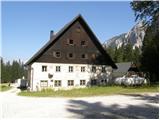 2
2 3
3 4
4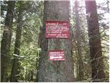 5
5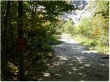 6
6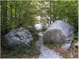 7
7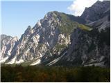 8
8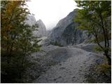 9
9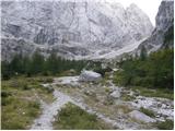 10
10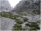 11
11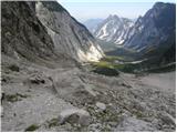 12
12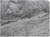 13
13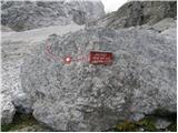 14
14 15
15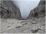 16
16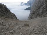 17
17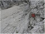 18
18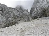 19
19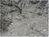 20
20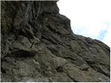 21
21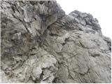 22
22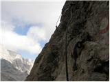 23
23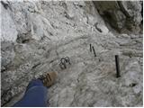 24
24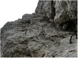 25
25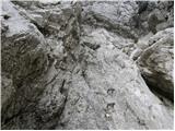 26
26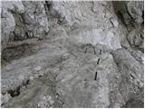 27
27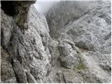 28
28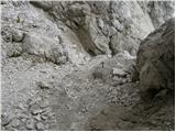 29
29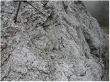 30
30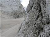 31
31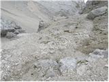 32
32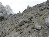 33
33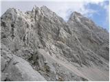 34
34 35
35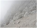 36
36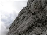 37
37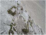 38
38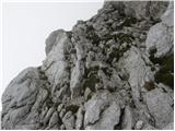 39
39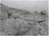 40
40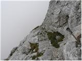 41
41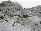 42
42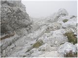 43
43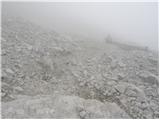 44
44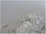 45
45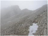 46
46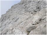 47
47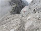 48
48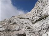 49
49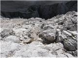 50
50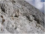 51
51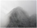 52
52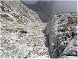 53
53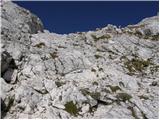 54
54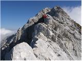 55
55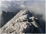 56
56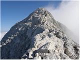 57
57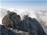 58
58 59
59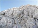 60
60 61
61 62
62
Discussion about the trip NC Planica - Jalovec (via Jalovška škrbina)
Show older messages
|
| Gost1. 09. 2006 |
The hike is exceptional, but the start at Ozebnik is complicated due to snow and caution is required
|
|
|
|
| Gost24. 09. 2006 |
In the wall below the notch there could be a peg or wire rope more, but in normal conditions it's quite OK. Crossing Golčica in damp conditions I can't imagine.
|
|
|
|
| Gost10. 06. 2007 |
Don't advertise. We know what the tour to Jalovec is like. Magnificent. In snowfall, fog and wind to Jalovec???? And with a guide. Irresponsible!!!
|
|
|
|
| Gost11. 06. 2007 |
This is about the guide's responsibility to take his client on a tour at -20, fog, wind, snowfall. I've been to Jalovec several times, but in bad weather we all prefer to avoid mountain tours and thus not risk our own and others' lives. P.S. This has nothing to do with driving on our roads.
|
|
|
|
| Gost12. 06. 2007 |
I see you didn't get this discussion. You're swimming in your own galaxy under the impression of the conquered peak. When you've reached more of such sweetest peaks, your feelings and thoughts calm down. Everyone experiences and relives their own peaks. And experiences them the most and most deeply. You went to the top for yourself, that's why the exaggeration—-20, snowfall, fog, wind doesn't make you a greater hero, as far as I know ..... I've experienced winter ascents to Jalovec several times, summer ones too. I never went on a tour in snowfall. If there were normal winter conditions, only fog at the top, those are different conditions than you described. In the next 15 years I wish you many beautiful tours, undertake them with all seriousness so you can dream long. I don't want to steal your dreams at all, I have quite a few of my own real beautiful experiences.
|
|
|
|
| Gost12. 06. 2007 |
Thank God you only dreamed ... Preželj wouldn't set out in such even in dreams, neither alone nor with a client.
|
|
|
|
| Gost12. 06. 2007 |
I fully agree with the guest before me. Safe steps and much beauty in the mountains to all hikers.
|
|
|
|
| Gost12. 06. 2007 |
I see that you still don't understand this discussion. I wish you all dreams, pleasures and unforgettable experiences in the mountains. But I can't understand going into the mountains with snow, fog, wind, -20° with a guide. Is it safe? Many times snow has caught me on the way, but the mountaineer turns back and doesn't expose himself. More than 30 years I've been going to the mountains, and I have quite some experience with weather. If there was only fog at the top and no view, you added the rest to make the ascent a bit more dramatic for the forum. Believe me, you shouldn't play with nature. It is always right. It wins overwhelmingly often. I wish you safe travels in the mountains, nice dreams further with wife and children. P.S. with this I'm ending the discussion with you, I hope we don't meet in the bivouac, it's nice to have smart interlocutors, or enjoy the silence alone with nature.
|
|
|
|
| Gost13. 06. 2007 |
I'm reading this discussion and wondering, is it really smart to go to the mountains in such conditions, even with a guide? Definitely not! This question would be smart to ask elsewhere. Maybe at the Slovenian Guides Association. But I think that you a bit "overinflated the conditions".
|
|
|
|
| Gost13. 06. 2007 |
I see that galaxy wants to say that experience in the mountains means nothing. I myself have been going there for many years and many times experience helped resolve an unpleasant situation. When you have more experience and less on the tongue, then really nice tours, feel free to show up on the forum again.
|
|
|
|
| Gost13. 06. 2007 |
Oh man, such arrogant windbags are sometimes really a bit superfluous in bivouacs.
|
|
|
|
| Gost13. 06. 2007 |
Since you're so experienced, you should know that in such conditions it's really not for pushing to Jalovec. Šmarna gora is also beautiful in snow, fog, wind, just that -20° is not often.
|
|
|
|
| Gost13. 06. 2007 |
I think the gentleman guest meant: don't make bad advertising. Taking a client to Jalovec in such conditions? Bad advertising for the guide. But I think it was all in galaxy....... I mean the weather conditions.
|
|
|
|
| Gost13. 06. 2007 |
But I think galaxy is right too. If the guide knew the tour was possible, they went. If he knew it was too dangerous, they would have turned back, because he commands or leads the tour. No point reinventing the wheel..
|
|
|
|
| Gost14. 06. 2007 |
I assume the guest has as much experience with mountaineering as with writing. That's why galaxy is right. Discovering hot water in the mountains is nonsense, gathering experience, being cautious and prudent is recommended. It would certainly be wise to hear the other side of the story too. The guide's. Safe steps to all.
|
|
|
|
| Gost16. 06. 2007 |
Really bold action, this tour. I wonder if this is even possible with all these really accurate weather forecasts.
|
|
|
|
| Gost16. 06. 2007 |
Accurate weather forecast? For today thunderstorms were forecast but the sun was shining 100%  Weather is one of many things that are very hard to predict. Weather is one of many things that are very hard to predict.
|
|
|
|
| Gost18. 06. 2007 |
A really very warm sun was shining over Šmarna gora. In the Bohinj mountains there were thunderstorms. We experienced that in the hut. After the thunderstorm there was excellent visibility. They forecasted the same weather. It's NOT hard to forecast the weather in today's times, some don't understand it or grasp it just like some other things still. You've already changed your name on the forum several times, Galaxy, but your communication style remains unchanged.
|
|
|
|
| Gost18. 06. 2007 |
You can't even read properly. If you've been hiking for 30 years already? Then you should know that you wait out the thunderstorm in the hut, because it's especially nice to continue the tour afterwards. But you really don't know that, because you're bullshitting. You know yourself who's laughing at you.
|
|
|
|
| Gost18. 06. 2007 |
I agree, if you've really been hiking in the mountains for 30 years, you surely know yourself that a winter tour to Jalovec is something normal. If the conditions are okay. This discussion started only because of your extreme conditions: snowfall, fog, wind, -20 degrees. AND THIS WITH A GUIDE? Unacceptable for any mountaineer. From your replies, I conclude you're quite smart.... the comment from your guide would really have been welcome.
|
|
|
|
| Gost18. 06. 2007 |
All who participated attacked you, your unseriousness and lies. I hope you'll have the chance to laugh for a while longer. I advise you to go to another forum. This one is for hikers and mountaineers. Bullshitters are elsewhere. Whom did they attack except you? You don't understand again. In 30 years one thunderstorm.!!!!! You catch it nicely yourself. P.S. This was the second guest who didn't want to discuss with you anymore. I advise everyone not to deal with you anymore. We wanted the guide's comment but you're just bullshitting. Bullshit in your galaxy with yourself.......
|
|
|
|
| Gost21. 06. 2007 |
You, man, have serious problems with grammar (Kaga lerih sa) and controlling anger. If you don't know yet, don't shout on forums (exclamation marks if you don't understand). So I advise you to calm down. And one more thing. It's madness to be in the mountains when thunderstorms are forecast. I don't know who you are to dictate who can be on the forum and who not. You're not admin. Not God either. You can't accuse a person of lying if you don't even know him. If he has been hiking for 30 years (if true) in mountains even in winter it means he has experience. Did you ask him where he has been everywhere? No. Have a nice day.
|
|
|
|
| Gost21. 06. 2007 |
If you read forums you would know what all is written there, and what letters and signs are used. This site or forum seems very useful, interesting and full of good information to me. Therefore I find it inappropriate to boast about reaching the summit with a guide in such extreme conditions. Almost every day we can hear about accidents in the mountains, unfortunately often tragic ones, so let's rather encourage learning safe hiking in the mountains than boasting about such a tour. Leave God alone. Better to make a mistake in text than in the mountains. If you go there at least a little with soul then you will hopefully understand my reaction to such a feat. If you are at the level of galaxy's feats then it's different. Where he has been everywhere is not important at all, important is also with what responsibility towards oneself and ultimately towards others too, where we go and return back too.
|
|
|
|
| Gost22. 06. 2007 |
No, I don't understand. Accidents happen even in perfect conditions. If I am at his level I don't know because I don't know him. And you neither, so I don't know what experience you have. I have no intention to write to you why I hike in mountains because everyone hikes for a certain reason. He wrote that this is his biggest adventure. I believe him. But I don't understand if you consider yourself such an experienced mountaineer why go to mountains in thunderstorms and bad weather.
|
|
|
|
| Gost22. 06. 2007 |
I forgot to tell you one more thing. It's very important where he was because if he didn't have experience, the mountain guide would never take him. Do you think the guide is so stupid to venture with an inexperienced client to a mountain like Jalovec? Not even under any circumstances, my friend. Marko Prezelj is a winner of the golden ice axe. That says everything about his experience. Four years ago my girlfriend and I wanted to do a winter ascent to Triglav. The guide asked about our experience. When we told him, he flatly refused us. Galaxy has tasted what it means to be on the mountain in such weather. Surely he's not crazy to repeat such a feat considering he has a family. And he has a lot of experience for the future. You know Himalaya was and is conquered also in bad weather. Have a nice day.
|
|
|
|
| Gost22. 06. 2007 |
I hardly believe that Prezelj went to Jalovec with a client in such conditions: precisely because he is prudent, knows what such conditions on the mountain mean and does not expose himself to danger. When and how Himalaya is conquered I know myself from experience. Otherwise, the Slovenian guides association will say something about it. Interesting question.
|
|
|
|
| Gost22. 06. 2007 |
But if you have experience from Himalaya (I don't believe that bragging) then I don't know why you burden yourself so much because of this ascent. I know what it is. He honestly pissed you off and you can't calm down. He wrote that the matter is finished for him. Probably he withdrew from here because he experienced a "nice welcome". Probably he thought there are people here who will understand him not tear him apart. To be honest: sometimes I'm ashamed to be Slovenian. For me the matter is also finished. And once more: if you have Himalayan experience (I don't believe you even under torture and pity that you convince me because I don't believe you) you should know that it's madness to go to mountains in bad weather and thunderstorms. Have a nice day.
|
|
|
|
| Gost23. 06. 2007 |
I believe you are ashamed of what you did. This discussion developed only regarding the safety question of this tour. Feelings, experiences, intolerance and similar things were not the issue here at all. Every real mountaineer has enough of his own experiences and explaining them on the forum is sometimes meaningless, because the reader does not experience it so deeply and the experience is devalued. Otherwise read the text more carefully. It was nice weather, we waited out the thunderstorm in the hut, after the thunderstorm everything was washed, view superb, if you really hike somewhere, you must know this. What you believe and what not is your business. You brag so much that you think everyone swallows it. I hope that with my experiences, including Himalayan ones, I will continue as before safely and contentedly hiking in the mountains. I have a nice day without your wishes.
|
|
|
|
| Gost23. 06. 2007 |
Guest, I hope you will continue hiking in mountains only to Himalaya from now on, as no one wants to meet such arrogant guys on their trails. Sell your years of experience elsewhere and don't think that because of them you are omnipotent. Your opinion doesn't interest me at all, so direct your typical choleric outburst at my post to yourself. Nice greetings to all normal and prudent mountaineers!
|
|
|
|
| Gost23. 06. 2007 |
No galaxy you've now relieved your soul. Typically, the best defense is attack. At least for some. On our trails there are really too many irresponsible ones like you, that's why we read in the newspapers. My experiences are useful to me and mean something to me. But I don't want you judging my opinion at all. Post, what does that mean in this context? To calm down, mountains are suitable for that. But for you not too high. Šmarna will be just right. Nice day and greetings also to abnormal and imprudent mountaineers. I hope this post won't be deleted. Concluding the debate with you.
|
|
|
|
| Gost12. 08. 2007 |
Please provide the difficulties and conditions on the Tamar-Jalovec path...
thanks for the reply...
|
|
|
|
| Gost12. 08. 2007 |
Ask galaxya, he masters it, otherwise a guide can advise.
|
|
|
|
| Gost13. 08. 2007 |
Very demanding path, helmet obligatory!
|
|
|
|
| Gost4. 02. 2008 |
On the photos the lower part of the secured path looks quite scary - especially since there are no anchors, and then there's that Goličica. Can it be compared say to Jubilejna on Prisank, to Škrlatica or to Bambergova?
I get a bit scared just looking at these pictures ))
|
|
|
|
| Gost4. 02. 2008 |
I'd say it's in difficulty somewhere between Škrlatica and Bambergova (via Plemenice). In dry conditions the path isn't that dangerous since there are excellent footholds, but in fog it's probably very slippery.
|
|
|
|
| stom226. 09. 2011 |
If anyone hiked this trail this month (September 2011), I'd ask for information on what the passage over the glacier is like (possible snow, bergschrund). Thanks and best mountain greetings
|
|
|
|
| ljubitelj gora6. 07. 2012 |
In early summer under the Škrbina there is still a snowfield which is very dangerous to cross without ice axe/crampons. Ozebnik is closed, there is a sign there and God help those who go up through Ozebnik, as higher right under the summit there is a huge amount of scree and loose rocks waiting to avalanche into the valley, also the described path through Škrbina is exposed to rockfall. So as not to seem too know-it-all please additionally inquire with the hut keeper in Tamar or contact the path maintainers. lp
|
|
|
|
| 6umek619. 08. 2014 |
On Sunday 17.8. we visited Jalovec via this route. I just want to warn that this year there is still a lot of snow and you need to cross 3 snowfields.. Especially one, just before reaching the wall, is particularly exposed and steep, so I suggest anyone choosing the route takes at least an ice axe. Nice mountain greetings
|
|
|
|
| jrepse21. 10. 2014 |
On 20.10 I walked this path on the descent from the top. The snowfields are not difficult, that part below before the melišče is passable without problems. Otherwise the path requires heaping measures of caution and concentration, especially on descent. Helmet is mandatory! Safe steps to all! lp
|
|
|
|
| gorskakoza10. 08. 2017 |
Has anyone recently gone through Jalovška škrbina? I'm wondering if there's any snow? Are crampons needed?
|
|
|
|
| MANGRT10. 08. 2017 |
On Tuesday everything was dry, no new snow has fallen yet. No worries on the trail.
|
|
|
|
| gorskakoza11. 08. 2017 |
Thanks, and best mountaineering regards!
|
|
|
|
| Hikoncil18. 08. 2019 |
And does anyone know if there is still a late snow patch???
|
|
|
|
| matic42. 08. 2020 |
Below the icefall it's the end. Without winter gear access to the fixed protections in the wall is currently impossible.
|
|
|
|
| hijacker16. 09. 2020 |
Has anyone gone through the notch recently?
Is there still any snow, or will winter gear still be needed?
|
|
|
|
| ajva16. 09. 2020 |
Winter gear not necessary, there is no snow. I went on this path one week ago. Lp
|
|
|
|
| Jernej96829. 07. 2024 16:05:21 |
On Saturday, 27.7.2024, I did the descent from Jalovška škrbina into the ozebnik. Right at the end, just before exiting the wall onto the scree, there is one torn-out bolt, which makes the safe exit difficult. Some free climbing is required. Additional difficulty is the snow in the ozebnik that needs to be crossed. The snow height here is currently over 3m, the narrow ledge is about 1m wide. I made it to the other side through a natural tunnel under the snow with the help of an ice axe. Crampons are not necessary.
|
|
|
|
| jaar31. 08. 2024 13:44:21 |
Has anyone hiked there in the last few days, planning a trip for next week... how is the snow... best regards
|
|
|
|
| lijaneja31. 08. 2024 20:51:18 |
I definitely advise against going over the glacier.
|
|
|
|
| jaar3. 09. 2024 18:02:27 |
Great, thanks for the info
|
|
|
To post a comment you must log in:
If you do not yet have a username, you must first
register.