NC Planica - Bivak pod Kotovim sedlom (on scree)
Starting point: NC Planica (931 m)
| Latitude/Longitude: | 46,476°N 13,7241°E |
| |
Route name: on scree
Walking time: 3 h 55 min
Difficulty: easy marked way
Elevation gain: 1046 m
Elevation difference along the route: 1145 m
Map: Kranjska Gora 1:30.000
Recommended equipment (summer): helmet
Recommended equipment (winter): helmet, ice axe, crampons
Views: 7.404
 | 1 person like this post |
Access to starting point:
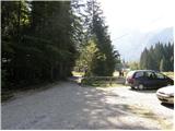
a) First we drive to Kranjska Gora, then we continue driving towards Rateče. When we arrive at the roundabout near Rateče, we take the exit in the direction of Planica. This is followed by some more ascent and we arrive at the large parking lot next to the Nordic Center Planica, where we park in the paid parking lot. The price for passenger cars is 2.5 euros / day (March 2019).
b) Through the Rateče border crossing we drive into Slovenia, then we soon turn right towards Planica. This is followed by some more ascent and we arrive at the large parking lot next to the Nordic Center Planica, where we park in the paid parking lot. The price for passenger cars is 2.5 euros / day (March 2019).
Route description:
From Planica we continue along the gravel road towards Dom v Tamarju, before the road enters the forest it splits into two parts. We continue along the slightly right road in the direction of the footpath towards Tamar (slightly left is the drivable road, which is closed to public traffic).
The path ahead leads us along the road, which passes the last parking lot of NC Planica, enters the forest and is converted into a cross-country ski track in winter. This is followed by an ascent along a gentle road, which mostly runs through the forest, when the path leaves the forest, there are viewpoints along the path with signs of what can be seen. Higher up, the forest thins out several times or we leave it for a while, so beautiful views open up to the mountains that rise above Planica and Tamar. When we are already quite close to Dom v Tamarju, a wonderful view of Jalovec opens up to us, the path splits.
We continue slightly left (slightly right the source of Nadiža) and a few minutes later we join the drivable road, along it past a chapel we arrive at Planinski dom v Tamarju.
We continue along the marked mountain path in the direction of Jalovec and Ponc (left Slemenova špica). The path ahead leads us through the forest, which quickly brings us to the next junction, where the path to Ponce branches off to the right. We continue in the direction of Jalovec and continue the ascent along the path, which still ascends gently for a short time through the forest. When we come out of the forest we first ascend for some time along extensive, partly already overgrown gravel fields, then gradually arrive at the scree, which continues towards Jalovčev ozebnik. Along the scree we ascend to the marked junction, where we continue left (right Kotovo sedlo and Jalovec past the bivak pod Kotovim sedlom) in the direction of Jalovška škrbina. In the continuation the path continues to ascend along the scree, then brings us to the next junction, where we continue right in the direction of Kotovo sedlo (slightly left Jalovec via Jalovška škrbina).
The path ahead ascends transversely to the right and gradually passes onto less steep slopes. Higher up, the path levels even more and, past several large boulders, brings us to the junction in Veliki kot.
Here we continue right downhill in the direction of Dom v Tamarja (straight Kotovo sedlo and Jalovec) and continue the path through a more plateau-like world full of larger rocks and smaller boulders. A few minutes lower on the left side we notice a larger boulder and next to it a sheet metal bivak, to which we have a few dozen more steps.
In fog the bivak is harder to find.
Planica - Dom v Tamarju 0:45, Dom v Tamarju - razpotje Mali kot 1:30, razpotje Mali kot - razcep pod Ozebnikom 0:55, razcep pod Ozebnikom - razpotje Veliki kot 0:35, razpotje Veliki kot - bivak 0:10.

Along the route: Dom v Tamarju (1108m), Odcep za Ponce (1119m), Helioport Pod Brkico (1357m), Razpotje Mali kot (1564m), Razcep pod Ozebnikom (1864m), Razpotje Veliki kot (2067m)
Photos:
 1
1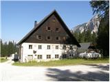 2
2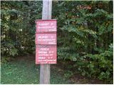 3
3 4
4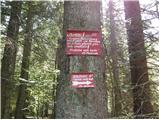 5
5 6
6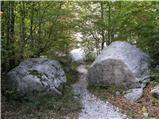 7
7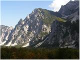 8
8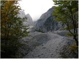 9
9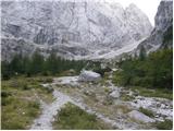 10
10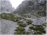 11
11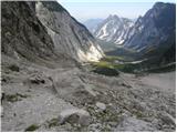 12
12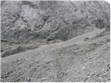 13
13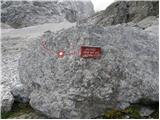 14
14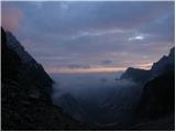 15
15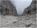 16
16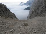 17
17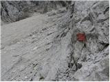 18
18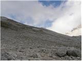 19
19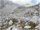 20
20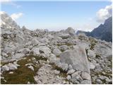 21
21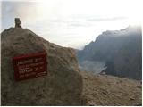 22
22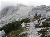 23
23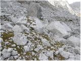 24
24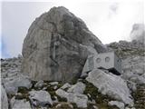 25
25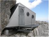 26
26
Discussion about the trip NC Planica - Bivak pod Kotovim sedlom (on scree)
|
| risank1. 11. 2012 |
IS THIS PATH MORE SUITABLE FOR ASCENT OR DESCENT? THANKS IN ADVANCE
|
|
|
|
| turbo1. 11. 2012 |
What are you whispering, say it out loud 
scree fields are usually such that for every two or three steps up, you take one or one and a half steps down 
so it's more sensible to tackle them on the way down 
|
|
|
|
| ljubitelj gora1. 11. 2012 |
Descent; for ascent better take another route.
|
|
|
To post a comment you must log in:
If you do not yet have a username, you must first
register.