Na Razpotju - Krofička (hunter's way)
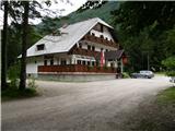
Starting point: Na Razpotju (770 m)
| Latitude/Longitude: | 46,392°N 14,6273°E |
| |
Route name: hunter's way
Walking time: 3 h 40 min
Difficulty: difficult pathless terrain
Elevation gain: 1313 m
Elevation difference along the route: 1313 m
Map: Kamniške in Savinjske Alpe 1:50.000
Recommended equipment (summer): helmet
Recommended equipment (winter): helmet, ice axe, crampons
Views: 17.649
 | 2 people like this post |
Access to starting point:
We drive to Luče (to here from Mozirje or over Kranjski rak) and further towards Logarska dolina. Soon after the village of Solčava we come to a crossroads, where the road to Logarska dolina branches off to the left. We turn left towards Logarska dolina (toll payment) and drive along the road to the signs for the mountain hut at Klemenča jama. We park on the parking lot near the pension Na Razpotju. In front of the pension, parking is allowed only for guests.
Route description:
From the parking lot, we head onto the forest road in the direction of Klemenča jama. After a few minutes of walking, a wide path branches off to the left towards Klemenča jama. We take this path, which starts to ascend. A quite steep path soon brings us to steep slopes, where with the help of a steel cable we cross a slightly exposed gully. The path, which continues ascending, soon brings us to the spot where a wall blocks the path. In front of us we notice a cave and above it a marking that directs us into the cave. When we step into the cave, we see that it is not a cave, but a nicely made tunnel through which we continue. In the tunnel, a steel cable assists us, though we need it more on the descent than on the ascent. On the other side, along a wide path in a gentle ascent, we cross an exposed ledge. The path ahead goes into the forest and continues ascending steep slopes that are dangerous for slipping when wet. Further, over a small bridge, we cross another gully, then the path brings us to a less steep section where the path from Dom Planincev joins. We continue gently upwards along a wide path that soon takes us out of the forest. Only a short ascent remains on the grassy slope to the mountain hut Koča na Klemenči jami.
From the mountain hut, we continue straight in the direction of Ojstrica on the path that enters the forest after a few tens of meters. The path, which ascends moderately to steeply through the forest, brings us higher below rocky cliffs that are not overly crumbly. The path then veers right away from the cliffs and brings us to a junction, where we continue left in the direction of Ojstrica along Kopinškova pot (right Škarje). Further on, we emerge from the forest onto panoramic slopes overgrown with dwarf pines and individual larches, from which a nice view opens towards the northern wall of Ojstrica. Further ahead, we pay attention as soon, to the left from the marked path to Ojstrica, an unmarked hunting path to Krofička branches off. When we notice a cairn (approximately 10 minutes before Kopinškova pot crosses to the other side of the ridge), we turn left onto a poorly visible path that takes us across a partly rocky and partly grassy slope surrounded by dwarf pines and individual trees to below the foot of the northwestern cliffs of Krofička. Further, we ascend a wide gravelly gully, from which soon to the right a nice secured and exposed passage opens (see cairns). A short very steep ascent follows, which we overcome with the help of a steel cable, and the path brings us to an initially narrow and exposed ridge. The ridge, which is lightly overgrown with dwarf pines, then quickly widens and with the help of some fixed protections brings us to probably the most difficult part of the path. With the help of a steel cable (partly damaged 12.6.2008), we climb an almost vertical and exposed chimney about 10 m high. The steepness then suddenly eases, and the path brings us to sunny meadows (the slope is called Zadnji travnik), where the path gradually fades. We continue the ascent traversing in the direction north to northeast across a gradually steeper slope. When we reach an already quite steep slope, we stop the traversing ascent and continue straight upwards on a very steep slope. If we wish to avoid the final steep ascent, a little below the summit we can continue somewhat to the right and climb to the summit along a slightly less steep "path" that brings us to the top from the right (eastern) side. PS: from the point where we leave the marked path to Ojstrica, it becomes technically and orientationally demanding. In fog, I advise against the ascent; due to falling rocks, it is good to have a helmet.
Na Razpotju - Klemenča jama 1:10, Klemenča jama - Krofička 2:30.

The trip can be extended to the following destinations: Matkov kot
Photos:
 1
1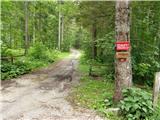 2
2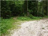 3
3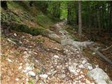 4
4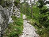 5
5 6
6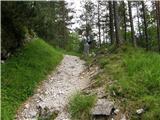 7
7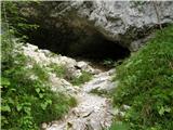 8
8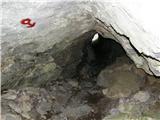 9
9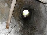 10
10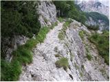 11
11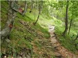 12
12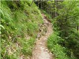 13
13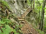 14
14 15
15 16
16 17
17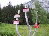 18
18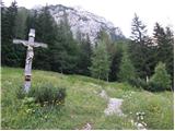 19
19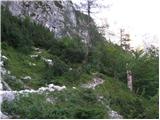 20
20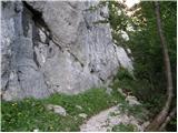 21
21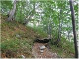 22
22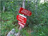 23
23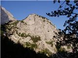 24
24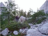 25
25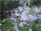 26
26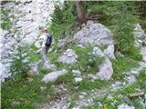 27
27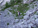 28
28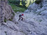 29
29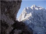 30
30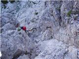 31
31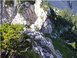 32
32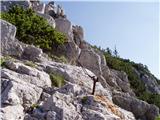 33
33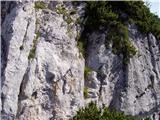 34
34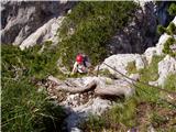 35
35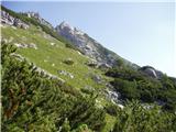 36
36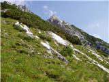 37
37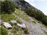 38
38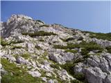 39
39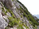 40
40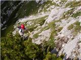 41
41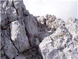 42
42 43
43
Discussion about the trip Na Razpotju - Krofička (hunter's way)
|
| Jany25. 08. 2008 |
I also tried Krofička via the unmarked hunter's path. Up to the ascent to Zadnji travnik it went fine, then I couldn't find any passage through the scrub to the top. I returned the same way, which on descent is even more dangerous than on ascent.
I plan to repeat the whole thing soon, so please help or provide a more detailed description of the second part from the meadows to the summit.
Thanks and LP
|
|
|
|
| Tadej25. 08. 2008 |
If you look at the picture at the link below, you can see from afar the easiest passage through the scrub. The picture shows two peaks (Krofička main peak is the right one).
http://www.hribi.net/slika.asp?pot=29764
|
|
|
|
| fpetel128. 10. 2008 |
Looks quite demanding where the damaged cable is. Can you self-belay there, or at least pull yourself up?
|
|
|
|
| Tadej29. 10. 2008 |
The cable is still holding, but due to two torn-out bolts it's quite wobbly. A bit more caution and it's fine. As for self-belaying, I think it would only be in the way.
|
|
|
|
| garmont3. 07. 2011 |
Today I climbed this path. I also couldn't find the passage through the brush, so I headed towards the top of Krofička through the notch (on the other side there is a secured path). The path is really exposed, so I used the rope under the notch (thanks for the prusik at the top). The previously mentioned safety gear is OK.
Lp
|
|
|
|
| krasovc3. 07. 2011 |
I also had problems. Actually the path (if we can call it that) runs a bit more to the right from the one you took, say about 300 m further on. I noticed this when I previously descended exactly where you went up, but I was alone and it wasn't easy.
For the next ones, calculate that the last part goes in a straight line towards the top (not easy but doable, a bit of climbing).
|
|
|
|
| Punklc29. 08. 2011 |
Yesterday I was on Krofička, exactly on this path. Through Škrbina the path is still quite exposed, but secured. The chain from the upper picture is wobbly, self-belaying would in my opinion really just be a hindrance. You need to make sure that before you clip onto this chain, you tension it well, because in the middle of the height it's wrapped around a driven peg. When you reach the clearing, a nice path opens through meadows and bushes towards the summit. When you are below the summit (almost to the end of the meadows) you can choose two paths. One goes directly under the wall of Krofička. There climbing skills will be needed, the other, i.e. to the right, I took myself. The path through the meadows is already somewhat overgrown (visible). You need to keep to the right direction and before the first bushes a cairn is found. What bothered me was that despite the bushes I had to keep right all the time and search for the continuation even through the bushes (I got a bit off track). At the end of my path and in the picture above, the ascent to the summit is well visible, which is somewhat crumbly. Just before the summit there is a short branch to the left and we're up. Safe steps!
|
|
|
|
| b.temlin28. 11. 2011 |
On 27.11.2011 we went along the hunting path, more off-trail to Krofička. A little trouble before entering the path under Škrbina, we weren't sure of the entry. Continuation, after ascending the hanging cables we went diagonally across the slope towards the saddle below the summit of Krofička, then directly towards the summit a bit of scrambling and above the last dwarf pines to the right to the top. No snow anywhere, but the marked path on the descent was icy and snowy. The ascent is very interesting, not for ascending in fog and beginners, with rare cairns we didn't help ourselves much, weather fantastic-short sleeves, photos at WWW.pdmaticams-drustvo.si.
|
|
|
|
| Avanturistični kozorog21. 06. 2012 |
21.06.2012 - Junction clearly visible, cairn on the path. (approx. 10 min before Škrbina - 1800 m.a.s.l.) Through the first notch, nicely made path with pegs and fixed cables. Higher up the two pegs are still uprooted, but do not cause problems. Then diagonally cross the meadows, at the wall first 50 m.a.s.l. along the wall, then to the right to dense dwarf pines. To the top of the dwarf pines we scramble on all fours along the dwarf pines looking for good holds and passages, but mostly straight up. The summit is to the right. Good luck
|
|
|
To post a comment you must log in:
If you do not yet have a username, you must first
register.