Most Boka - Boka waterfall (by bed)
Starting point: Most Boka (400 m)
| Latitude/Longitude: | 46,3183°N 13,4948°E |
| |
Route name: by bed
Walking time: 1 h 15 min
Difficulty: difficult pathless terrain
Elevation gain: 280 m
Elevation difference along the route: 300 m
Map: Julijske Alpe - Zahodni del 1:50.000
Recommended equipment (summer): helmet
Recommended equipment (winter): helmet, ice axe, crampons
Views: 19.992
 | 5 people like this post |
Access to starting point:
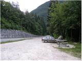
From Bovec, we drive towards Kobarid or vice versa. Before the Boka bridge (from the direction of Kobarid, after the bridge) there is a parking lot where we park.
Route description:
From the starting point, we first walk to the bridge, from which a nice view opens up on the Boka waterfall. We continue to the other side of the bridge, and from there right on a wide path in the direction of Boka (on the other side of the bridge are signs for the source of Boka). The path first leads us along a wide path, which quickly splits into two parts. We continue straight on the lower unmarked path (left viewpoint on the Boka waterfall), which after a few minutes brings us to the river. Further, we initially ascend along a small footpath that runs on the left side of the river (right bank), then it disappears. The riverbed of Boka then narrows, and passages along the riverbed are blocked by steep walls. We continue in technically somewhat more demanding terrain, since to advance we have to climb from one rock to another (carefully).
The further direction of ascent is clear, but the passages are not and they differ depending on the water level (the lower the water, the more passages are available to us). After some 10 minutes of climbing on wet rocks, a nice passage opens up for us on the right side. We continue on a relatively steep but less visible small footpath, which higher brings us to larger boulders that block our relatively easy passage. Here, at high water level, our path ends.
But if the water is relatively low, we find the best passage over the boulders and continue the ascent along the rushing river. Higher, a demanding passage opens up on the left side (continuation along the riverbed is no longer possible), which is very exposed to falling rocks. With great caution, we climb one level higher and the "path" brings us to somewhat less steep slopes from which a view of the waterfall opens up on the right side. Further, we can climb along less steep scree to the foot of the wall (danger of falling rocks) and from there descend right to the waterfall.
The path is both technically and orientationally demanding and in a larger part exposed to falling rocks and slipping.

Photos:
 1
1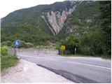 2
2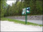 3
3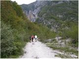 4
4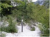 5
5 6
6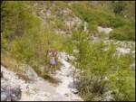 7
7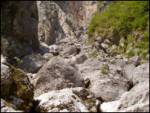 8
8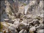 9
9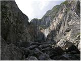 10
10 11
11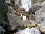 12
12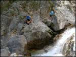 13
13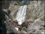 14
14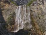 15
15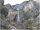 16
16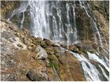 17
17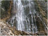 18
18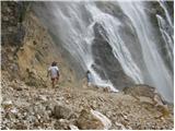 19
19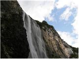 20
20
Discussion about the trip Most Boka - Boka waterfall (by bed)
|
| Gost6. 11. 2006 |
Definitely worth the effort. But you need to take the amount of water seriously. And the difficulty - not for everyone..
|
|
|
|
| trinity11. 06. 2008 |
We were about a month ago at the viewpoint, but I'm interested where the little path to the waterfall is....to the source at the top of the waterfall...I know it exists because we saw people there....
who knows?
|
|
|
|
| matejqo10. 09. 2011 |
Instructions not very clear, I also wanted to go to the source, but ended at the viewpoint 
|
|
|
|
| petruša11. 09. 2011 |
Before the bridge you have to go along the path, but you went behind the bridge and reached a viewpoint.lp
|
|
|
|
| matejqo11. 09. 2011 |
Today I corrected the mistake and reached the spring ... weather was great, started at 7:55 from the parking lot. At the spring I basked in the sun. Luxury
|
|
|
|
| planinar_iz_ravnine5. 09. 2015 |
Hi, I've already gone up the stream bed twice, but never to the waterfall. It's not clear to me where the demanding passage is supposed to open up. The only path that seemed possible to me was up the scree, but beyond that I really have no ideas. Could someone perhaps explain in more detail where it's possible to get up? I'd be grateful for a photo..
|
|
|
|
| IgorZlodej5. 09. 2015 |
The marked trail starts on the eastern side of the bridge, impossible to miss it.
|
|
|
|
| ajax5. 09. 2015 |
mountain plain, third time lucky. 
|
|
|
|
| planinar_iz_ravnine6. 09. 2015 |
OK, why does the trail description say go along the stream bed and somewhere left? But from the pictures I see the approach is from the left side. The marked trail is from the right.
Third time maybe, who knows
|
|
|
|
| IgorZlodej6. 09. 2015 |
You go along the stream bed when the waterfall is frozen, to the base, then two scrambles and over 
|
|
|
To post a comment you must log in:
If you do not yet have a username, you must first
register.