Starting point: Most Boka (300 m)
| Latitude/Longitude: | 46,3183°N 13,4948°E |
| |
Walking time: 1 h 45 min
Difficulty: difficult marked way
Elevation gain: 550 m
Elevation difference along the route: 650 m
Map: Julijske Alpe - zahodni del 1:50.000
Recommended equipment (summer): helmet
Recommended equipment (winter): helmet, ice axe, crampons
Views: 15.641
 | 2 people like this post |
Access to starting point:
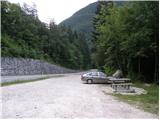
From Kobarid we drive towards Bovec or vice versa. Before and after the Boka bridge there is a parking lot on which we park.
Route description:
From the parking lot, we first cross the main road (if we parked on the right bank of Boka we first have to cross the bridge). At the bridge we will notice a signpost, which directs us to a cart track that leads along the left bank of Boka. The cart track soon turns into a footpath, which soon brings us to a junction. We go left following the signs »Slap Boka, izvir« (Boka Waterfall, source). The path starts to ascend more steeply and is slightly exposed in some places. The path runs slightly to the left all the time and occasionally a view opens up through the forest towards the bed of Boka and the Bovška kotlina basin. In the upper part the path becomes quite exposed and some steel cables assist us. At the end there follows a descent down a very steep slope along the steel cable and then an exposed crossing towards the source.
The path runs through the forest all the time, so that from the starting point we can already clearly see where the path runs.
Photos:
 1
1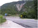 2
2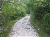 3
3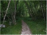 4
4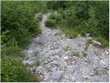 5
5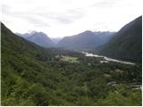 6
6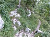 7
7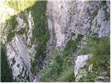 8
8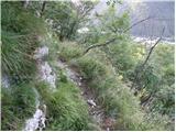 9
9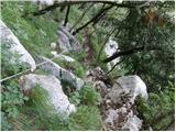 10
10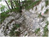 11
11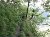 12
12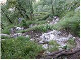 13
13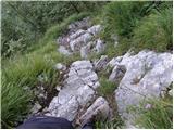 14
14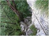 15
15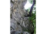 16
16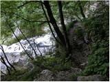 17
17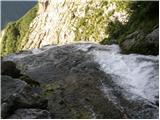 18
18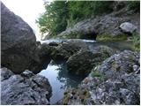 19
19
Discussion about the trip Most Boka - Boka sping
|
| barjus2. 08. 2009 |
This descent is really nice if you know what you're getting into. Shame that nowhere at the start does it say how far it is, so a random visitor can prepare for the trip. We wanted to just check out the waterfall and started without water, so there was a bit of a crisis. Such a path should be better marked at the bottom.
Otherwise it's nice up there, but really exposed.
|
|
|
|
| VanSims22. 04. 2012 |
At the bridge there is no longer the signpost mentioned in the description (April 2012). The problem of the difficult path is solved by putting up a warning about the difficulty of the path, not by simply removing the signpost so that nothing happens to a random tourist.
|
|
|
|
| IgorZlodej22. 04. 2012 |
No one removed that post, but the lower part simply rotted and probably fell down behind the bridge. Anyway, the post was put up by LTO and not PD. There are still many such posts in Bovec area (some also knocked down) . .
|
|
|
|
| B222. 04. 2012 |
Since the path is really exposed at least in one place (wire rope) and is marked with hiking markers, PD Bovec, which manages the path and (doesn't!) supplies and maintains it, should put up an appropriate directional sign about the difficulty of the hiking path at the starting point at the bridge (red sign with all data on the direction of the destination, walking time, altitude of the starting point and name of PD - in this case PD Bovec), which manages, maintains and supplies the hiking path. It should also include the difficulty marking of the path (in this case, since the path is VERY difficult) which is a triangle with an exclamation mark! The wooden LTO post with a sign and destination name - is pure misleading of visitors for such a difficult path... The consequences of such misleads are unfortunately known...
|
|
|
|
| IgorZlodej22. 04. 2012 |
I'm really surprised by this entry, when it's known who took care of the paths for over 10 years and also why he stopped.
|
|
|
|
| VanSims22. 04. 2012 |
The path is not extremely difficult, but difficult. But in weather like yesterday it was slippery and dangerous at key points.
Maybe over the rock just before you reach the spring (about 200-300 m), which you can only cross with climbing skills or go around and barely manage with a tree as a hold, install a wire rope
It would also be nice if our PD stopped operating with triangles and exclamation marks but wrote the path marking in words, especially on heavily visited paths where even hiking-illiterate people go.
That the one who maintained the paths stopped doing it (we know who it was  ), is completely his free decision. The PD's problem is if they don't find a replacement for him. ), is completely his free decision. The PD's problem is if they don't find a replacement for him.
|
|
|
|
| Irina22. 04. 2012 |
Another one who has no idea who took care of the path and why they don't anymore.
|
|
|
|
| BT8822. 04. 2012 |
But it doesn't surprise me at all, this is pure intrigue, my grandma would say 
But if the path is a bit tricky, I can go  and along the way see the beauties of this nature, which is unmatched and along the way see the beauties of this nature, which is unmatched
|
|
|
|
| B222. 04. 2012 |
BT88, it's not just for painting arrows, it's also for restoration and these are not pranks misleading people into adventures that could be their last... I also agree with Van Simis that not all visitors are literate and don't know what a triangle and a triangle with an exclamation mark mean... In (almost) every mountain hut there's a PZS leaflet that would explain the dilemmas right away... These signs are internationally agreed upon... Anyway, another sign about the path's difficulty wouldn't hurt - the directional sign (red) wouldn't be any more expensive for that - and the illiterate (uneducated) would be informed and wouldn't venture onto such paths, if they even know, or they should first be taught what a difficult or very difficult mountain path means... And we're back to another topic - and the mountain rescuers and others will have work...
|
|
|
|
| VanSims23. 04. 2012 |
@B2: Well, the path itself is otherwise fine. The fixed protections are in good condition, markings too (some additional ones somewhere might not hurt), the problem is only the signage i.e. the marking of the destination itself and the notice about the difficult nature of the path.
|
|
|
|
| ljubitelj gora14. 04. 2013 |
I was on this path today, the path is dry, picture 15 above it shows a rockfall, a bit further towards the spring it needs some fixing with a peg, winter does its thing, the path is not for everyone, proper footwear and don't forget water, otherwise it's quite a steep path, if you want to see the spring along the way after already one tour, the waterfall can be seen from the bridge
|
|
|
|
| 5376358. 05. 2014 |
The trail is moderately difficult, mainly due to the steep final descent to the spring. At one point a landslide carried away part of the trail and some improvisation is needed. The fixed ropes are in quite poor condition.
|
|
|
To post a comment you must log in:
If you do not yet have a username, you must first
register.