Mojstrana - Vrtaška planina
Starting point: Mojstrana (675 m)
| Latitude/Longitude: | 46,4552°N 13,9321°E |
| |
Walking time: 2 h
Difficulty: easy marked way
Elevation gain: 787 m
Elevation difference along the route: 787 m
Map: Kranjska Gora 1:30.000
Recommended equipment (summer):
Recommended equipment (winter): ice axe, crampons
Views: 33.929
 | 4 people like this post |
Access to starting point:
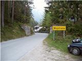
We leave the Gorenjska highway at the Hrušica exit and follow the road ahead in the direction of Kranjska Gora. Just a little before the village of Dovje the road which goes to Mojstrana (Vrata, Kot and Krma) branches off to the left. We follow the road ahead in the direction of the Vrata valley and we drive there only a short time because we will soon notice mountain signposts for Vrtaška planina by the road. We park on the parking lot by the road which is situated a few meters ahead.
Route description:
From the parking lot, we descend along the road a few meters downwards, where a signpost points us to a wide footpath. The path initially ascends moderately and in a few minutes brings us to a junction, where we continue straight (right leads the path to the vantage point Grančišče).
The path soon after that crosses a shorter muddy part of the path, then turns left and then ascends steeper and steeper. The path ahead is steep and runs through the forest. After an hour and a half of walking, the steepness decreases and the path passes to scree slopes. Next follows crossing of a wide and with a fence secured artificial ledge (fence is intended for safety of livestock), from which a nice view opens up on surrounding peaks. The path then for some time returns into the forest and again steeply ascends. A little higher, the steepness decreases, we cross a pasture fence and in a few additional minutes of walking, we step onto the mountain pasture Vrtaška planina, where on the right side we notice a shepherd hut, which has an emergency bivouac in the attic of the house.

Photos:
 1
1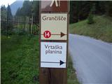 2
2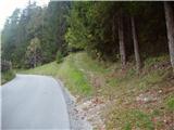 3
3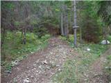 4
4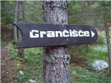 5
5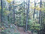 6
6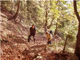 7
7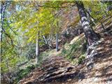 8
8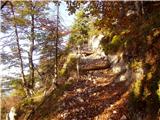 9
9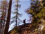 10
10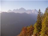 11
11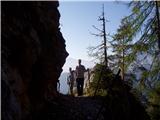 12
12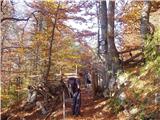 13
13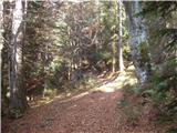 14
14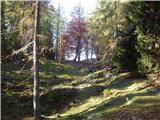 15
15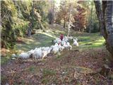 16
16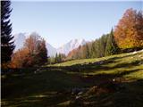 17
17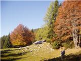 18
18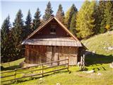 19
19
Discussion about the trip Mojstrana - Vrtaška planina
|
| Gost19. 06. 2007 |
Can someone tell me if this ascent is comparable to the ascent to Jerebikovec or Kamniški vrh via that steep variant? Thanks for your answers and good luck!
MiR
|
|
|
|
| Gost19. 06. 2007 |
As for the steepness, it's quite similar to Jerebikovec.
|
|
|
|
| Gost20. 06. 2007 |
Yes, to me the path to Vrtaška seems a bit longer and equally steep, but more interesting. I recommend it.
|
|
|
|
| Gost23. 06. 2007 |
What about the construction of the road to this alpine pasture? A few months ago I heard they were going to build a road. I myself hope there won't be one.
|
|
|
|
| Gost23. 06. 2007 |
Road? Brotherhood of sick minds alias profiteers.
|
|
|
|
| Gost26. 06. 2007 |
Oh God, don't let them build a road to the pasture. If there's a road, there will be no more peace. Let us mountaineers who like to move on our own power and despite abundant sweat overcome the altitude (sometimes also puffing up the slope and cursing our knees along the way) and thus reach the goal. The satisfaction is then indescribable. Good luck!
|
|
|
|
| Gost27. 06. 2007 |
What about disabled people who would also like to see the pasture....Mojca
|
|
|
|
| Gost27. 06. 2007 |
As far as I know they are building this road for easier access of livestock to the pasture and not for tourists. I assume it will be more of a track than a road.
|
|
|
|
| Gost27. 06. 2007 |
Well, they are NOT BUILDING anything! The path for livestock has been built long ago.
But the photo of the sign for Graniščice pleased me; usually it's written as Ganciše in maps.
The path to Vrtaška is similar in steepness to Jerebikovec, just longer, as one of the predecessors already said. Only, I've never walked it in 2h 15, even if I went really slowly. So, if you're going to Vrtaška, maybe just to the pasture, don't rush up the slope.
best regards, Domacinka
|
|
|
|
| Lj6. 08. 2012 |
Maybe someone knows why at this starting point there is no longer the sign from the 2nd photo or any marking for the starting point to Vrtaška planina? Is the path perhaps closed?
|
|
|
|
| Daaam6. 08. 2012 |
I don't know why there's no sign, but almost certainly the path is not closed...
|
|
|
|
| Laščan6. 08. 2012 |
Starting point is on photo 3., park on photo 1. From parking lot go back towards Mojstrana ca. 300m, past Triglav range model left above the road. Path or continuation is well traceable, recommend extension to Vrtaška ridge. Wonderful views, verified last year in late autumn.
|
|
|
|
| Lj6. 08. 2012 |
Laščan, now it's all clear, I'll go check it out live soon. Thanks and best!
|
|
|
|
| potepinka6. 08. 2012 |
The signpost is still there, or rather it's a pillar with plaques. But these plaques are obviously new and only have numbers and pictures (hiker, cyclist). Previous marking (my opinion) was better. 
Paths and their numbers are described in the trail map - HERE
Laščan has already well described how to reach the starting point.
Good luck!
|
|
|
|
| Lj7. 08. 2012 |
Yes, Potepinka, I misunderstood this description, I looked for the starting point ahead of the parking and not back, as Laščan explained. More heads more know... Good luck to you too on your paths! Best, Ljubica
|
|
|
|
| AdryBK27. 07. 2013 |
can you also eat something at the hut?
|
|
|
|
| POLJANC27. 07. 2013 |
You can if you have something in your backpack. Lp.
|
|
|
|
| capraibex2. 09. 2013 |
We visited Vrtaška planina on Saturday, starting from the beginning of Vrata valley. After a steep well-marked path we reached the goal in less than two hours. One of the most beautiful pastures, we agree, despite the closed hut. The livestock was driven to the valley a few days ago due to lack of pasture.
|
|
|
|
| Navadni Nimda20. 06. 2014 |
Last time I also checked Vrtaška. I can't believe how beautiful this alpine pasture is, from the first steps below onwards. Of course, if you go even higher (about 300 m above the hut), you reach such a spectacularly phenomenal viewpoint that one just stands still. You don't see a view like that easily.
It is a bit steeper from bottom to top, but worth every step. Vrtaška is a real beauty! 
|
|
|
|
| fonko4. 07. 2015 |
Last Sunday was at Vrtaška planina. Nice excursion with beautiful views. You won't find stamps at the planina or nearby peaks (that's what the hut owner told me) as Czechs stole them all.
|
|
|
|
| Majdag28. 05. 2018 |
Vrtaška planina from Peričnik... Before the bridge over Triglavska Bistrica, there is no more parking space. Logs are piled everywhere. The path from Peričnik to Vrtaška planina is not exactly easy if you don't know where it runs. There are many narrow paths and branches too. Most of them head back down the valley on this path. Ticks are already at work.
http://jelenkamenmajdag.blogspot.si/2018/05/vrtaska-planina-od-pericnika.html
|
|
|
|
| Jusk23. 03. 2020 |
Today after a long time I chose this path for a hike through the forest, you need to sweat and maintain fitness the path to the pasture is clear, a few minutes before crossing the fence in picture 14 snow patches start appearing here and there, after crossing that fence there's suddenly much more of it, up to around 15-20cm here and there. Since it was quite cold today the snow is also nicely frozen.. peaceful path, didn't meet anyone
|
|
|
|
| Jusk15. 07. 2020 |
Today after work this path tempted me again, it's still as steep as ever otherwise no special features, well-trodden path. No living soul was noticeable at the mountain pasture, not even livestock, so it was really peaceful
|
|
|
To post a comment you must log in:
If you do not yet have a username, you must first
register.