Matkov kot - Mrzla gora (via eastern ridge)
Starting point: Matkov kot (850 m)
Route name: via eastern ridge
Walking time: 4 h
Difficulty: very difficult marked way
Elevation gain: 1353 m
Elevation difference along the route: 1360 m
Map: Grintovci 1:25000, KSA 1:50000
Recommended equipment (summer): helmet, self belay set
Recommended equipment (winter): helmet, self belay set, ice axe, crampons, lamp
Views: 69.718
 | 5 people like this post |
Access to starting point:
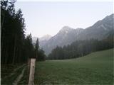
We drive to Luče (to here from Mozirje or over Kranjski rak) and further towards Logarska dolina. Soon after the village Solčava we come to a crossroads, where a road branches off to the left into Logarska dolina, and we continue straight another approx. 1000 m towards Pavličevo sedlo and then we turn left over a bridge towards Matkov kot. We park at a suitable place.
Route description:
A wide path leads us across scree past the hunting cottage on our left side. Blazes direct us to the right side into the forest, where the path gently rises towards the head of the valley. In a good hour we get to a steeper part of the valley, where the forest ends. The path, interrupted by a deep ravine with boulders, climbs up to an overhanging rock face beneath which lies the natural wonder – Matkov škaf. Up to this point the walk took us approximately 2 hours.
From the logbook at Škaf we cross an exposed ledge towards the right and then in zig-zags we continue on a steep rugged crumbly slope. In half an hour we are at the steep gully, which we overcome with the help of steel cables. Above it, we continue on a steep, exposed terrain towards a rocky barrier above us, below which there usually lies a snow field. The passage into the rocks and over them depends on the amount of snow. When snowless the path leads us very exposed along a ledge to the right to the end and then with the help of pegs several tens of meters steeply upwards. We follow the blazes a little to the left and when we cross the gully the serious problems on this part of the path end. In zig-zags we ascend to cirque Latvica, and from here through it we reach the eastern ridge of Mrzla gora. After that, the path becomes again demanding and follows the ridge, in parts exposed and modestly secured, bringing us to the top of Mrzla gora after approx. 1 hour.
The path is only modestly protected with fixed safety gear, and there is even less of it than on the trail from Okrešelj.
The described path to Mrzla gora demands a skilled and experienced mountaineer!

Photos:
 1
1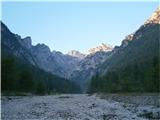 2
2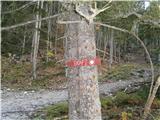 3
3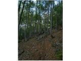 4
4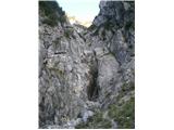 5
5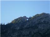 6
6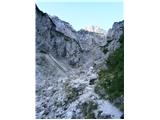 7
7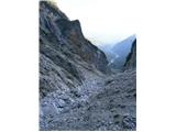 8
8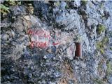 9
9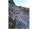 10
10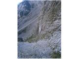 11
11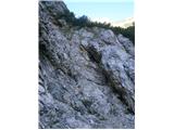 12
12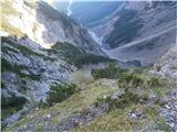 13
13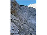 14
14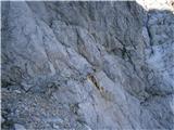 15
15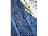 16
16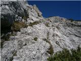 17
17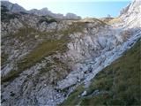 18
18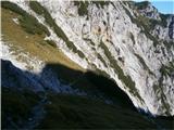 19
19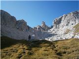 20
20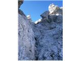 21
21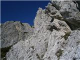 22
22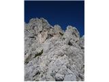 23
23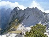 24
24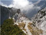 25
25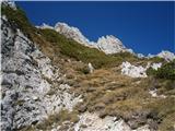 26
26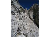 27
27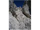 28
28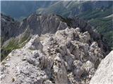 29
29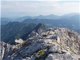 30
30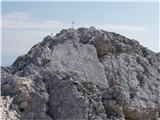 31
31
Discussion about the trip Matkov kot - Mrzla gora (via eastern ridge)
Show older messages
|
| namor210. 02. 2012 |
super tour, I'm already looking forward to hiking it! http://www.hribi.net/slike/smile.gif http://www.hribi.net/slike/smile.gif
|
|
|
|
| janez.novak12. 02. 2012 |
I would ask the experts which path to Mrzla gora is technically more demanding - the one from Matkov kot or from Okrešelj (Mrzli dol)? Thanks for the answer - Janez
|
|
|
|
| otiv12. 02. 2012 |
The path from Matkov kot is somewhat "easier", but still demanding and nothing to underestimate.
|
|
|
|
| garmont13. 02. 2012 |
In my opinion, just the opposite.
The demanding passage is under the rock barrier, where snow persists well into summer (ice axe, crampons). The path from Latvice to the summit is very crumbly, to me personally even more so than the path from Okrešelj. There are hardly any fixed protections, so self-belaying is out.
I recommend ascent from Matkov kot, descent to the Okrešelj side. It is true, though, that no path is exactly easy.
Best regards
|
|
|
|
| Edina13. 02. 2012 |
Both paths are demanding and require some mountaineering experience, stable weather, helmet from equipment, above all respect for the path and the mountain. According to Mr. Andrej Stritar, the summit of Mrzla gora could easily be declared one of the most difficult to access in KSA. When it comes to marked paths, I would agree with him, otherwise even in my youth Mr. Peter Ficko wrote: "... due to the difficult access, the discovery of the summit of Mrzla gora was among the last acts of planned exploration by Dr. J. Frischauf. He reached it from the easiest - eastern side, in 1877, with the help of farmers Matka and Piskernik (Plesnik)."
I agree with garmont that the suggested circular tour is certainly the most beautiful, which should be early enough so as not to miss the special views of the wealth of Grintovec mountains offered at the cross on the summit of Mrzla gora.
|
|
|
|
| janez.novak13. 02. 2012 |
I was on Mrzla gora once - from Okrešelj. I can say that so far I haven't walked such a demanding marked path in KSA or the Slovenian Julians - and I've walked almost all of them.
|
|
|
|
| Paintball15. 02. 2012 |
I was on Mrzla gora 2x, both times via circular path Okrešelj - Mrzla gora - Matkov kot. My opinion is that the path from Okrešelj is slightly harder. Briefly, my impressions: path from Okrešelj more exposed, from Matkov kot more crumbly. As predecessors already added, some experience needed, proper equipment (self-belay not feasible because very few fixed protections), and a clear head is required.
But I emphasize that this circular path does not bring you back to the start, so transport is a problem.
|
|
|
|
| dprapr15. 02. 2012 |
For fans of pathless terrain, the nicest approach is via Matkova krnica, along the ridge to Krnička gora and further to Mrzla gora.
If Matkova kopa is added, it is one of the nicest ridges around here!
Of course there is also Hudi prask, which is more crowded and doesn't seem as appealing to me as the previously described variant.
Every approach to Mrzla gora requires at least some experience or guidance from a more experienced mountaineer.
Best regards to all and lots of enjoyment on these paths!
|
|
|
|
| ToniP8. 03. 2012 |
Hi, I have a question, has anyone been to Mrzla gora in the last few days? And what's the trail like?... Can you get up there just with a helmet and good footwear, without crampons, rope, and such....?
thanks for the reply! Best regards!
|
|
|
|
| Janez Seliškar8. 03. 2012 |
ToniP:
Up is still possible, but down definitely not!
|
|
|
|
| mosovnik8. 03. 2012 |
At this time of year, access to M. gora is "allowed" only to experienced mountaineers with full winter gear, regardless of which direction they take towards the summit and a bit more, you need special respect for this lady in KSA and treat her gently and she will be very grateful to you.
Good luck!
|
|
|
|
| ljubitelj gora8. 06. 2012 |
Is this trail harder than the trail from Logarska Dolina?
|
|
|
|
| dprapr8. 06. 2012 |
In my opinion no. It seems more pleasant for descent (meadows above Škaf), than for ascent.
But this is a subjective assessment!
Regards
|
|
|
|
| pohodnik3829. 06. 2012 |
Hiked the path on 27.6. Wonderful path, quiet corners, not so demanding as it seemed easier to me than the western path where I descended. Regarding the path everything is ok, no snow on the path anymore but beside it.
VIDEO
Regards! Tone
|
|
|
|
| pohodnik383. 07. 2012 |
And a few more pictures and impressions from the trail
PICTURES
otherwise I've already said my piece on the conditions.
Regards!Tone
|
|
|
|
| Janiel7430. 07. 2012 |
Could someone please tell me in more detail which route to MG is the easiest and why? I don't like crumbly terrain...Thanks
|
|
|
|
| otiv30. 07. 2012 |
Janiel74 Mrzla gora is known precisely for its crumbly terrain, so you have no choice. Both marked paths are demanding.
|
|
|
|
| Kita30. 07. 2012 |
If you don't like crumbly terrain then you should go to Velika planina...
|
|
|
|
| nadap30. 07. 2012 |
There is no easy path to Mrzla gora, verified on Saturday, I felt like a spider since it is not secured with iron and you have to put in effort, even on all foursand that's right, as it preserves its beauty and inaccessibility.....
|
|
|
|
| Janiel7431. 07. 2012 |
@kita: thanks... I won't write what I think about such...
|
|
|
|
| TejaB31. 07. 2012 |
Sadly, you kind of asked for such a response. If you write that you would go to MG, but wouldn't walk on crumbly terrain, it's like saying you want to go to the mountains, but not uphill.
As they wrote to you, 2 marked paths lead to Mrzla gora, both are very demanding and crumbly, but if you decide, I'd say the one from Mrzli dol (from Okrešelj) is less crumbly than this one from Matkov kot.
|
|
|
|
| Janiel7431. 07. 2012 |
@TejaB: thanks. Yes, I know there are always some very self-absorbed ones who think they are something special .... even here It doesn't impress me much for such people.
|
|
|
|
| dprapr31. 07. 2012 |
As TejaB wrote, the path from Mrzli dol is also less crumbly in my opinion, but mostly more exposed. From Matkov kot it is exposed in sections. First above Škaf, then in the jump below Latvica and also in the upper part below the summit. As I already mentioned in one entry above, however, I still find it easier, more suitable for descent, than the one at Okrešelj.
Overall, both paths are demanding, interesting in their own way, but climbing-wise the one from Mrzli dol is nicer. There are not many fixed protections on either path. If you're used to slings and pegs, you'll miss them on both paths.
Best regards
|
|
|
|
| Janiel7431. 07. 2012 |
@dprapr: so it would really be ideal to go up from Okrešelj and down via Matkov kot. Considering I've only been hiking for 1 year and am completing SPP and only Mrzla gora (optional) is missing besides 3, I've decided to go here too. I don't have much experience. Which path can I best compare it to? Maybe just a section? So far I've done MM, Žrelo, Slovensko na Mangart, Koroško Rinko, Tominškovo, Prag, Jezersko Kočno... I'd just like to know as much as possible about the path.
|
|
|
|
| Janiel7431. 07. 2012 |
Especially since I read very respectful comments about this mountain. But is it even sensible to take SK, given that there are almost no cables. Probably just extra weight?
|
|
|
|
| Janiel7431. 07. 2012 |
Oh, also Peco, Škrlatica, Raduha, Gradiško Turo I've done, if we're talking about some climbing sections...
|
|
|
|
| dprapr31. 07. 2012 |
It's hard to compare Mrzla gora with any of those paths you've done. All those paths are well secured, which we can't say for Mrzla gora. But trying doesn't hurt - if on the path from Mrzli dol, where there are still protections at the beginning, you find it too difficult, you can still turn back. Namely, when there are no more protections, you'll probably know right away if it's suitable to continue or not. Stick to the rule: I go up where I dare to go down too!
On the path from Matkov kot, the path is well secured up to Latvica. Only the summit part where you reach the ridge is poorly protected.
|
|
|
|
| dprapr31. 07. 2012 |
Regarding the via ferrata set, I've decided not to give statements anymore!
|
|
|
|
| Janiel7431. 07. 2012 |
@dprapr: thanks for all the advice.
|
|
|
|
| mukica25. 07. 2013 |
I'm interested if anyone has been around there these days if there's still snow cover and if winter gear is needed, we would do a loop and I know info from Okrešelj that it's dry to the top...Thanks
|
|
|
|
| pohodnik3825. 07. 2013 |
As far as could be seen from the top to Latvica there's no snow but how it is lower down I don't know.
PICTURE
|
|
|
|
| B.Smart19. 09. 2013 |
Hello.
Has anyone been to the summit this week after the snowfall? I'm wondering if the snow has persisted. I'd like to go up on Sunday, but I'm a bit concerned about the conditions, as I don't want to walk on any exposed section with snow underfoot.
|
|
|
|
| Mokara2. 07. 2014 |
Hello, tomorrow I plan to go to Mrzla gora from Matkov kot and I'm interested if there is still any snow on the path or if normal access without winter equipment is possible. Thanks for any information!
|
|
|
|
| andi23. 07. 2014 |
Last week it was already not possible to reach the col completely safely without crampons at least (was in the rain, snow more like glacier), higher up not at all (at least crampons and ice axe, and knowledge
|
|
|
|
| andi23. 07. 2014 |
Last week it was already not possible to reach the col completely safely without crampons at least (was in the rain, snow more like glacier), higher up not at all (at least crampons and ice axe, and knowledge
|
|
|
|
| Mokara3. 07. 2014 |
Thank you very much! We preferred another tour - more on dry ground
|
|
|
|
| Zgembo30. 08. 2014 |
I was on this tour today, snow is only at one end, but it can be nicely bypassed about 50m higher.
|
|
|
|
| mornar28. 10. 2015 |
What are the conditions from Matkov kot regarding snow?
|
|
|
|
| dprapr29. 10. 2015 |
Snowy mainly Latvica and partly below the jump. The ridge is almost bare.
|
|
|
|
| mojcadrev10. 07. 2016 |
5.7.2016 I visited Mrzla gora. It really is demanding. I went without crampons and had quite a hard time crossing the snow on Škaf. Otherwise it's a very crumbly trail. I have to admit, it was one of the hardest hikes I've done. The cables are torn, rocks are falling. Everything crumbles, very poorly protected. Where the cable was most needed, there isn't one. Below the summit there's nothing, no pegs or cables. But it was worth it and I'm proud of myself for reaching the top of Mrzla gora.
The trail is demanding and requires an experienced mountaineer. Helmet mandatory. Hats off to everyone who has been on it and those who plan to do it in the future. Good luck
|
|
|
|
| mojcadrev10. 07. 2016 |
No summit logbook at the top.
|
|
|
|
| urhpi8. 10. 2016 |
The trail didn't seem as difficult to me as you scare people here. Many secured trails are more demanding than this one. It's true there aren't many safety features, but they aren't necessary either. The hardest part for me was the passage directly under the overhang.
|
|
|
|
| Becar8. 10. 2016 |
Well, this is an example of a comment that shouldn't be taken seriously. For all trail visitors, the above hribi.net trail description suffices. And yes, the trail is among the most demanding, excluding via ferratas. Everything else is boasting.
|
|
|
|
| jax8. 10. 2016 |
Wait, what's exactly so controversial about the comment? The person gave their opinion about the trail. Is it only allowed if it doesn't differ from yours or what?
|
|
|
|
| Becar9. 10. 2016 |
Jax, don't stick your nose into things again every three days. I also just gave my opinion on his comment. Anyone who underestimates any of the trails to Mrzla gora, which is practically marked in all guidebooks as one of the most difficult to access, if not the most difficult (among marked ones) in our country, is not serious in my opinion. And moreover, misleads users of this forum.
|
|
|
|
| redbull9. 10. 2016 |
The trail is by no means too easy, for descent it's especially high difficulty, as slipping can happen quickly. Of the marked trails in KSA it was at least for me the most difficult on descent.
|
|
|
|
| Domch10. 10. 2016 |
Pictures 15 and 16 look creepy, probably that's the key part of the trail I assume.
|
|
|
|
| panoramik10. 10. 2016 |
Actually, the trail on these two pictures runs along a ledge which also has a fixed cable, though some pegs are pulled out here and there, otherwise it's not as scary live as on the picture. But it's true that full concentration is needed for descent, more than for ascent. Once you traverse it a few times, it all gets easier.
|
|
|
|
| Becar10. 10. 2016 |
The hardest is the summit section from the ledge onwards, especially for descent you don't know how to turn around. Pictures maybe don't depict the actual state in this section. There are hardly any safety features, very steep, crumbly terrain full of scree. A slip here can be fatal at any point.
|
|
|
|
| ljubitelj gora17. 10. 2016 |
On this trail a helmet is MANDATORY and not optional. Walked the trail to Latvice 17.10.2016
|
|
|
|
| marepn9555. 08. 2017 |
Today I was on Mrzla gora, started at five from Matkov kot and walked a good part of the path in the shade. The path must be taken with respect and it goes, the more demanding part is the return as my predecessors already said. Today it was ideal, rock dry, good visibility, maybe a bit too warm and consequently I only met the first hiker - a female mountaineer on the way back at the bottom, who was heading to the top.
|
|
|
|
| mornar20. 09. 2019 |
Is anyone going tomorrow or Sunday to Mrzla gora, I'd join if possible. I'm well prepared and used to hiking in mountains. Best regards.
|
|
|
|
| mornar21. 09. 2019 |
Today I went to Mrzla gora from Matkov kot, the path is very well marked and very well maintained. The path is very demanding and worthy of all respect. I would ask that the upper path description be corrected. When you reach Latvice, the hardest part only begins, not that the worst is already over. Regards.
|
|
|
|
| mornar23. 09. 2019 |
Administrator, please correct the path description from Ltvice onwards because that part is the most difficult on the entire path. It can mislead someone a lot. Regards.
|
|
|
|
| dprapr23. 09. 2019 |
It is quite well described. The difficulties are mainly below Latvica. On the ridge there are some unprotected "rollers", but that's all. Try sometime in more winter conditions, you'll see that you'll breathe a sigh of relief at Latvica.
|
|
|
|
| mornar23. 09. 2019 |
Dear Drago, I wrote how the conditions are in summer. But I don't intend to polemicize with anyone. I express all respect to you for walking this path in winter. Regards.
|
|
|
|
| garmont23. 09. 2019 |
The description has been corrected, although I am convinced it was already completely fine before.
But if you are not sure of your abilities, then rather don't set off for this beautiful mountain. Regardless of the description above...
|
|
|
|
| mornar23. 09. 2019 |
Thanks for the correction, but keep to yourself where someone will go. Regards.
|
|
|
|
| CarpeDiem2472. 02. 2020 |
Mrzla gora = for me the most demanding mountain among the marked ones within KSA. So far only up from Okrešelj. Next time need to make a loop. If I understand correctly, with two vehicles, because the starting point is quite far apart?
|
|
|
|
| LISAC28. 07. 2021 13:23:56 |
Hi. Does anyone have any info on the conditions of Matkov kot - Mrzla gora? Thanks and best regards.
|
|
|
|
| mokretic4. 09. 2021 18:03:49 |
Hi. For a circular route, is it better to start in Matkov kot or at Rinka?
|
|
|
|
| mirank4. 09. 2021 20:39:35 |
We went up from M kot and if we went again we'd do the same. Not because of the difficulty but because of the scree and especially the path load. Descent to the Okrešelj side was just fine.
|
|
|
|
| bbugari129. 09. 2021 18:10:32 |
On Sunday finally to Mrzla gora. I leave the car at the end of the asphalt in Matkov kot, then three times a very poorly marked path crosses the scree, and once more after the hut. Half an hour to here. Then a well-marked ascent begins above the end of Matkov kot, on the western (right) side. After an hour of walking from the car, the forest ends, but here a partly very poorly marked path begins, which soon switches to the eastern (left) side and after a nasty scree slope after an hour and a half from the car I reach the Škaf.
Actually, I didn't even notice that I went under the Škaf (into the Škaf) until I reached the logbook.
A nice ascent in the shade follows across a well-protected threshold, short scree, along a ledge and up to the beautiful pastures of Latvice.
Finally I reach the wall and here excellent climbing to the summit begins. The rock is excellent, compact and for a mountaineer used to grade I climbing (use of hands, highly recommended gloves) it poses no problems, of course in dry and clear weather. More problems are lower down, on nasty and steep but short screes under the Škaf and above the Škaf (before reaching the ledge). Especially on the lower scree (under the Škaf) the descent would be very demanding. The only problem in the rock (especially in clouds or fog) is orientation, as ordinary cairns do not show the way ahead, clear markers would be recommended...
No one was to the summit, the logbook at the Škaf showed that no one had been here for four days either. A short visit at the top, but more hikers were slowly coming from Okrešelj. Descent to Okrešelj cautious and slow, but the rock here is also excellent and full of good holds. From the car to the summit three and a half hours.
The approaches to Mrzla gora are beautiful and great that such easy climbing but marked paths exist in Slovenia.
Through Mrzli dol and past the memorial rock down to Okrešelj, then to the asphalt, and then (as usual) by bike to the car in Matkov kot!
Unfortunately I can't post photos of the Škaf here!
|
|
|
|
| dprapr29. 09. 2021 18:27:23 |
"...then three times a very poorly marked path crosses the scree, and once more after the hut."
If you follow the marked path, you only cross the scree 2x. Both times at the end of the meadows. Before the scree where the hunting hut is, the path leads between the pines and through the forest to the right.
You missed it! Otherwise, there is a nice view of the peaks above the valley and many people miss the junction from the gravel road.
"After an hour of walking from the car, the forest ends, but here a partly very poorly marked path begins,..."
If the path is clearly visible, there is no need to paint the rocks.
|
|
|
|
| bbugari130. 09. 2021 09:35:42 |
Yes, I probably missed that marked shortcut because of the generator noise at the hut around 7 a.m....
From the forest edge to the scree under the Škaf on the right side of the gully the path is not clearly visible, in good weather of course no problem, but on the longer section there is no marking at all, neither up nor down.
|
|
|
|
| Chasethesun20. 10. 2024 23:27:02 |
I was up there today, went on the path with awe, but it didn't seem anything special to me, of course it requires experience and full concentration, but it's comparable to many other very demanding paths in the Slovenian mountains. The most tricky is really that “sodr”, especially directly above the Škaf…
It was a wonderful day today, quite warm up there, Mrzla gora was basking in the sun..
|
|
|
|
| garmont21. 10. 2024 06:14:26 |
All those who write here that the path is easier than expected and that it's not such a "bogeyman" have obviously done their homework and informed themselves about the path's difficulty beforehand, as quite a bit has been written about it.
Then everything is easier...
|
|
|
To post a comment you must log in:
If you do not yet have a username, you must first
register.