Matizovec - Veliki vrh (Košuta)
Starting point: Matizovec (915 m)
| Latitude/Longitude: | 46,4145°N 14,3°E |
| |
Walking time: 3 h 20 min
Difficulty: easy marked way
Elevation gain: 1173 m
Elevation difference along the route: 1173 m
Map: Karavanke - osrednji del 1:50.000
Recommended equipment (summer):
Recommended equipment (winter): ice axe, crampons
Views: 182.948
 | 11 people like this post |
Access to starting point:
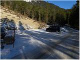
From the motorway Ljubljana - Jesenice, we take the exit Ljubelj and follow the road ahead towards the border crossing. We leave the main road at the spot where the signs for »camp and Podljubelj« direct us to the right. When we leave the main road, we will already after a few metres come to a crossroad, where we continue left in the direction of »Kofce«. Further on, we drive through the village on a slightly ascending road and then turn right in the direction of »Matizovec and Kofce«. This occasionally somewhat narrower road, which is asphalted in the lower part, we then follow to a larger marked parking lot, about 150 metres of elevation below the farm Matizovec.
Route description:
From the large free parking lot we continue on a macadam road, on which in approximately 20 minutes we arrive at the farm Matizovec.
From Matizovec we continue on a poorer road in the direction of Dom na Kofcah, where at several successive junctions we carefully follow the markers. After a few minutes of walking on the poorer road or cart track, the markers direct us onto a steep footpath, which first ascends transversely to the left, then transitions to a forested ridge, where it turns slightly to the right. Further, we ascend on a steep mountain path, which higher crosses the cart track and behind it gradually flattens. Just a little further, the forest thins out, the marked path turns right into the forest and a little higher joins the cart track, which ascends transversely to the right. The cart track higher turns to the left, and from the right also joins the marked path from Kala.
From the junction onwards the forest ends, and the increasingly scenic path in 5 minutes of further walking brings us to Dom na Kofcah.
From the mountain hut we continue in the direction of Veliki vrh and Kladivo on an initially somewhat less visible path, which starts to ascend across a scenic meadow. After 15 minutes of walking from the Dom na Kofcah we arrive at a nice viewpoint at the cross.
The path then descends slightly and in a few minutes brings us to the steeper slopes of Košuta. The path then ascends through a belt of dwarf pines, where it brings us to a junction. We continue straight ahead (right Kladivo and Kofce gora) on the path which ascends transversely across increasingly steep slopes. The path, which continues on the bare slope, soon brings us to a short steep section, where a steel cable assists us (easy). After passing this section the path turns slightly to the left and continues relatively steeply ascending across the grassy slope. The increasingly scenic path then brings us into a small valley, up which we climb almost to the border ridge, where the ridge path joins from the right. The path then from the valley again passes onto the southern slopes, where it bypasses the peak »Toplar (2000m)« on the southern side and afterwards brings us below the summit slope of Veliki vrh. The path, which for a while ran along the ridge, here withdraws from it and continues in a transverse ascent on the northern slopes. Higher up the path turns sharply right and then in a few minutes brings us to the scenic summit.
Starting point - Kofce 1:35, Kofce - Veliki Vrh 1:45.

Photos:
 1
1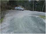 2
2 3
3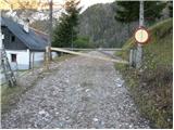 4
4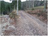 5
5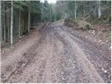 6
6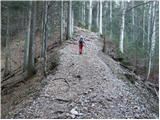 7
7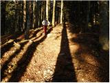 8
8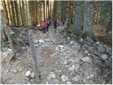 9
9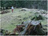 10
10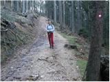 11
11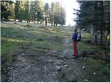 12
12 13
13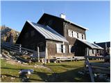 14
14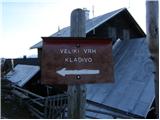 15
15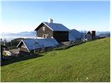 16
16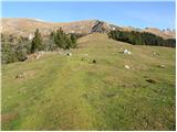 17
17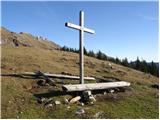 18
18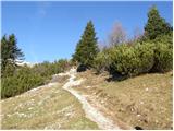 19
19 20
20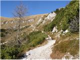 21
21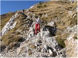 22
22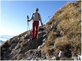 23
23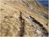 24
24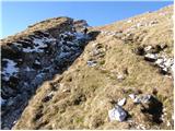 25
25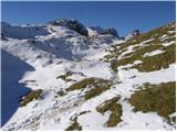 26
26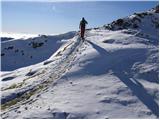 27
27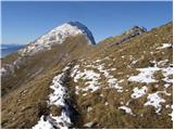 28
28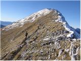 29
29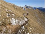 30
30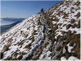 31
31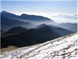 32
32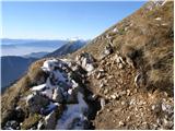 33
33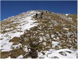 34
34 35
35
Discussion about the trip Matizovec - Veliki vrh (Košuta)
Show older messages
|
| Gost23. 09. 2006 |
Nice :) ...I recommend buckwheat dumplings at Kofce
|
|
|
|
| kolesar4. 02. 2007 |
Even in winter it's easy and quite frequented.
|
|
|
|
| Gost24. 08. 2007 |
 hm we'll see tomorrow how it is on the great peak hm we'll see tomorrow how it is on the great peak
|
|
|
|
| Lj26. 07. 2008 |
Always a beautiful hike past the friendly alpine pasture to the grassy ridge of Košuta. Today surprisingly not too crowded, perhaps due to the fickle weather (a bit of sun, a bit of clouds, and a bit of rain to conclude...)
|
|
|
|
| fpetel121. 11. 2008 |
I was up there on Tuesday 18.11. and it was similar to the pictures, only the snow on the south side except under the Veliki vrh summit had already melted - no crowd though, as I was alone, just a small herd of chamois I met on Kladivo and Kavka kept me company on Veliki vrh.
Nice sunny weather - even negative temperatures and a little breeze didn't bother. The black cat on Kofce was glad when I gave it some more fish
|
|
|
|
| Tadej21. 11. 2008 |
Fpetel1, the pictures were taken on Sunday 16.10.2008.
|
|
|
|
| milan markolcic6. 03. 2009 |
Well, a bit of winter idyll on Sunday 1.3.2009. I sweated quite a bit to the summit, but then it was all rewarded with a beautiful panorama. Even the strong wind and cold didn't bother me much. Regards and good luck
|
|
|
|
| jesen6. 03. 2009 |
Dear hiker!
On Sunday 01.03.2009 on the ridge route
above Kofce I found a mobile phone. I also reported the find to Radio Gorenc. Whoever lost it, please call Gorenc, they have my details. Best regards!
|
|
|
|
| jaz143. 10. 2009 |
Very nice trail. At Kofce they have good sour milk
|
|
|
|
| grahelj18. 05. 2010 |
I'm interested if anyone has first-hand info on the conditions at Veliki vrh? Is there still old snow on this path or just a few centimeters of fresh snow?
|
|
|
|
| Bojan_A18. 05. 2010 |
I haven't been there, but from home balcony I have a very nice view of that mountain. Mostly it's just new snow. On the summit ridge there's still old snow, but there shouldn't be panic.
|
|
|
|
| grahelj18. 05. 2010 |
How much snow is there? Could it melt by Saturday?
|
|
|
|
| mukica3. 06. 2010 |
I'm wondering if anyone has hiked around there in the last few days and how much snow is left? (could it be done without winter gear?)
|
|
|
|
| grahelj3. 06. 2010 |
There is not much snow. Last time it snowed up to Kofce but there is little of that snow left. I think winter gear is not necessary.
|
|
|
|
| efes25. 06. 2010 |
Went up with friends, overall it was great
|
|
|
|
| sportnick30. 06. 2010 |
One of the nicer trips. Not to mention the best štruklji at Kofce.
|
|
|
|
| Nix14. 07. 2010 |
Is the road to the Matizovec farm drivable?
Thanks for the answer
|
|
|
|
| kr neki14. 07. 2010 |
The road is normally drivable  . .
|
|
|
|
| novihribolazec17. 08. 2010 |
The road is passable but not exactly for low cars..on the path I ate my fill of raspberries and cyclamens stood out with their characteristic color from the brown and green tones of nature....I recommend the path to Kofce and then to Veliki vrh, not only because of the beautiful path, view and nature but also because of the extremely tasty struklji in the hut at Kofce and extremely hospitable caretakers...the path to the summit is steep and climbs through beautiful high mountain meadows and pastures....a short section of the path has a fixed rope, nothing special, the view outweighs all the energy and path....the weather was favorable to us, despite the fog and cold wind at the top...fantastic!
|
|
|
|
| kontiki25. 08. 2010 |
Poor path description. "Access to the starting point... head to the Ljubelj exit...". My friend thought we were going to Ljubelj-Podljubelj-Matizovec. It would be better if you had written Ljubljana-Kranj-Tržič-Podljubelj-Matizovec.
|
|
|
|
| Micky23. 09. 2010 |
Yesterday we went on foot from Podljubelj towards Veliki vrh. The day was really beautiful. Weather just as you wish. In an hour and a half we reached the hut and in less than an hour and a half to the summit. Excellent ascent. I recommend.
|
|
|
|
| navrhu8. 02. 2011 |
I just HAPPILY returned from Dom na Kofcah. STORY: after descending from Veliki vrh I first went to get a beer at the bar in Dom na Kofcah. I drank half a beer and then went to the hut where I wanted to order food, as I didn't see any waiters anywhere. I entered the hut. At the door leading from the dining area to the kitchen there was also an older gentleman who also wanted to order food. I asked him if I could order food here and he said he didn't know. Then I looked into the kitchen (where there was a woman and a man at the time; about 50-60 years old, preparing food - I don't know if either of them is the caretaker). I asked if I could order food here and the man replied that he prefers orders to be placed with the waiter. A minute later the waiter (male, 30 years old) came into the kitchen through the same door and first the aforementioned older man ordered food from him, then me. He told us to wait outside, he would bring the ordered food. After 15 minutes of waiting I saw this older man who had ordered food right in front of me coming out of the hut with a tray of food. Five minutes later the same waiter passed by my table and I called him, but he just said "RIGHT AWAY" and continued. I replied: "Not right away, I ordered food 20 minutes ago." There was no response, but the waiter went into the hut. After a good 5 minutes the waiter went around the tables again and I called him again, but this time he didn't even want to look at me, but ignored me and went into the hut. After a total of 35 minutes of waiting I decided to wait for lunch at home and went home.
This is my fresh experience which in my opinion shows that the caretaker is not capable of running the mentioned hut. The excuse will be that there were many guests, but here the caretaker's ability to anticipate and react quickly in such cases must be shown. Also, the caretaker should be a bit more proactive in selecting staff and controlling them.
I hope this entry will contribute to improving the work in the hut, which otherwise has a great location.
Otherwise everything is fine with my ascent. Weather excellent, sunny, very little wind. Recommended for families, as part of the family can stay at the hut, the more capable part can continue the path to Veliki vrh and back.
|
|
|
|
| mojca96410. 03. 2011 |
On Saturday I plan to go to Veliki vrh, wondering if someone who's been up there recently can tell me how much snow is left?
|
|
|
|
| JusAvgustin10. 03. 2011 |
A little, but winter gear won't be superfluous...
|
|
|
|
| Kofce11. 03. 2011 |
Hello! Fresh news today since it's quite warm today and the terrain is very wet, need to be very careful where to step, higher up where you're planning to go it's well trodden as quite a few have already set off up there today, WINTER gear is not superfluous! Nice ascent
|
|
|
|
| Parkeljc11. 03. 2011 |
Today we were on Veliki vrh, specifically from Matizovec to Kofce the path is mostly icy and crampons are highly recommended. From Kofce past Križ, then at the junction we turn towards Kladivo and along the ridge to peak Kofce. The path is clear, need to cross considerable amounts of wind-packed, now hardened snow. There is a high risk of slipping. From the peak we continue left below the ridge to Toplar. The path is mostly snowy, icy and muddy, so to Toplar we skirt snow patches, although slightly slippery. From Toplar towards VV the path is initially still muddy, covered with ice or snow, the last 100 m covered with a large amount of snow. The weather was wonderful, only from Toplar to the summit the wind increased. We descended along the usual path towards Kofce, from there via shortcuts and not the marked path due to iciness to Matizovec. And even faster down.
|
|
|
|
| el rocco9. 07. 2011 |
I was yesterday at the summit. Excellent trip, only at the top it was blowing so hard that I thought it would blow me to Austria. After a week of lounging at the sea it was just right to sweat fully.
|
|
|
|
| Lunca26. 07. 2011 |
Has anyone been up there these days when Košuta is white again?
|
|
|
|
| ben26. 07. 2011 |
No snow on Košuta, if you're interested!!
Best, B
|
|
|
|
| Matjaz_6525. 09. 2011 |
some of my photos from a similar circular path from 111 excursions ... from Planina Šija to Kofce .. to Veliki vrh and Kladivo .. and return via Škrbina and Planina Pungrat to Šija
I would rather suggest starting at Planina Pungrat ... which moves the boring walk from Planina Pungrat to Planina Šija from end to start of the path ... and shortens the drive on the otherwise quite bad road
|
|
|
|
| Kokta1. 11. 2011 |
Road in excellent condition...otherwise an excellent tour...recommended
|
|
|
|
| Janiel7416. 11. 2011 |
I plan to come here on Saturday. I assume there's no more snow? Can someone confirm first-hand? thanks
|
|
|
|
| sodnick16. 11. 2011 |
I went on this path on October 15 and the path was dry. I think it hasn't snowed since then. At least I don't remember. best regards
|
|
|
|
| Okmodko16. 11. 2011 |
I was over the weekend on Košutnikov turn and saw no snow anywhere. Not on the south, not on the north side of Košuta. What was white were only the Julians and the Austrian Alps in the distance.
|
|
|
|
| uhan114. 01. 2012 |
Hi.
Has anyone been to Veliki vrh recently? What are the conditions?
Best regards, thanks
|
|
|
|
| tagec15. 01. 2012 |
Hi Uhan1. Me and another 100 were at V.Vrh today, or rather up at Kofce. The hardest, or most icy part is above Matizovec, for the descent it's a bit awkward, above Kofce it's fantastic, I was sorry for the skis, although it's very crusted, the track is very well made to the top, going up I was without crampons because it's not icy, at the top I put them on for safe steps. Only one ski track from the top and it looks very good... skis in the garage Best regards Best regards
|
|
|
|
| Grand12327. 02. 2012 |
Hi, has anyone been to V. vrh in last days, interested in path condition, is it icy...?
Thanks, lp
|
|
|
|
| sodnick27. 02. 2012 |
We were on Sunday at Kladivo via Kofce gora. As far as I could see, I'm not sure if the path to Veliki vrh is trodden. The start of the path is trodden, then I think the track turns towards Kofce gora (along the little valley). We went along the ridge due to avalanche risk and I didn't see the path well (visibility wasn't optimal either). The snow was nicely firm (the crust mostly held the weight), after 12 o'clock it was already softening. We had crampons and ice axes.
|
|
|
|
| BožidarGlad23. 08. 2012 |
Please help me. How far can a large bus from Podljubelj go towards Matizovec and how much walking is it from the parking lot to Matizovec
Best regards, thanks
|
|
|
|
| capraibex23. 08. 2012 |
The road is not suitable for a larger bus, so in this case you have to start from Podljubelj, which extends the walk by almost an hour.
|
|
|
|
| jax23. 08. 2012 |
Or, if you have a slightly better group, start at Vrančku (right on the Ljubelj road) and go to the summit via the north face. Then descend to Matizovec and further to Podljubelj. This is probably the most beautiful variant, if the group is up to it of course.
|
|
|
|
| BožidarGlad23. 08. 2012 |
I have too large a group and not the best one.
Still, many thanks and LP
|
|
|
|
| Petrca16. 09. 2012 |
Wonderful walk. Nice path that rewards us at the end with unforgettable views of our mountains and valleys. Yesterday morning there was still a little snow, which started melting around noon. Nice!
|
|
|
|
| amarilis17. 09. 2012 |
From PODLJUBELJE, we set off on foot towards Veliki vrh. We expected anything but good weather from the weather, but it was quite favorable. It took us almost 2 hours to the hut, and the same to the summit. It was great, we'll repeat this trip, if not this year, then in the months of next spring when the weather will also stabilize somewhat. Regards
|
|
|
|
| jprim17. 09. 2012 |
Yes, on Sunday it was a bit worse than on Saturday, in the morning there was quite a fog, but then around 11 o'clock the sun peeked out here and there too,...
Regards!
|
|
|
|
| scorpio17. 10. 2013 |
Today it was stunningly beautiful... 1.5 hours from the parking lot to the summit, because it wasn't hot, no wind at the top, in short a day you rave about. With views to Snežnik even to Kadivo and back circular via Šija. Does anyone know the name of the peak about 30 m from Kladivo and somewhat lower in elevation? Or is it just a spur from Kladivo?
|
|
|
|
| scorpio18. 10. 2013 |
This one is on the left. And the right?
|
|
|
|
| klm18. 10. 2013 |
You mean the exposed summit that the path bypasses on the south side. Haven't seen a name anywhere.
|
|
|
|
| scorpio20. 10. 2013 |
No, that small summit 3 min off Kladivo to the left, then follows descent towards Škrbina...
|
|
|
|
| tinky21. 10. 2013 |
Not every rock can have its own name.
|
|
|
|
| scorpio21. 10. 2013 |
This "rock" is a two-thousander. I withdraw the question.
|
|
|
|
| klm21. 10. 2013 |
This "rock" is indeed a two-thousander, but it is not an independent peak, or rather does not meet those criteria. As I already mentioned, it has no name.
|
|
|
|
| tinky21. 10. 2013 |
Between V. Kladivo and Škrbina there is only XXIV/97, the elevation you can find on the border stone. A nice map of the entire Košuta can be found on the western wall of the hut on planina Dolga njiva. In this way, in June when I went to Košutnikov turn I found Ostrv (2126 m asl) XXIV/50.
|
|
|
|
| ljubitelj gora16. 11. 2013 |
In the morning I check the webcams and see how nice it is above about 1500 meters. I already had my backpack with all winter gear packed and drove to Podljubelj, parked at the parking lot at around 900 meters. I go up to the mountain hut and on to Veliki vrh; since I was a bit late, I went to the summit without longer breaks (2 hours). I already knew the path, the summit itself, the ridge from before. Just below the summit the sun greets me and it's already quite warm. On the summit it was windy but not overly cold, the views were very nice. After the break I go along the ridge to Toplar and Kofce gora, observing the glory the whole time, continue along the ridge and descend from Kofce gora to the hut, from there back to the starting point. On the return I went more slowly, stopping; if anyone is interested in pictures they are here: https://plus.google.com/photos/114400986607884783562/albums/5946886771627033409?banner=pwa
|
|
|
|
| Fero12. 12. 2013 |
Hey guys!
Do you know what is the situation about conditions on this path these days? I am planning to go to Košuta this weekend, but have no axe and crampons here with me in Slovenia... is it possible to hike without them?
Thanks for your response.
|
|
|
|
| Gvava13. 12. 2013 |
Hi!
There is not a lot of snow, but it's icy. So I recommend to you at least the small (with 4 or 6 teeth) crampons.
|
|
|
|
| -13. 12. 2013 |
Fero, you can borrow both in iglusport
|
|
|
|
| Fero13. 12. 2013 |
Thank you, Gvava and Nejc
|
|
|
|
| viharnik13. 12. 2013 |
Fero, the snow path on Veliki vrh is frequent and well made, but in any case you will need equipment mostly for descent from the mountain. View from the mountain is fantastic and breathtaking!.
|
|
|
|
| viharnik13. 12. 2013 |
Equipment you can borrow also in mountain shop Annapurna way, Krakovski nasip Lj. or Iglu sports only in Vič, Tržaška road, Lj.
|
|
|
|
| laik17. 06. 2014 |
This weekend I plan to go from Matizovec to Veliki vrh. Since I have a van, I'm interested in what the road to Matizovec is like, or if it's better to leave the van lower down. Thanks and best regards to all, Janez
|
|
|
|
| Bojan_A17. 06. 2014 |
The road to Matizovec is closed. Cars are parked at the large parking lot about 20 min walk below. Up to there the road is good and mostly asphalted.
|
|
|
|
| marinka6727. 08. 2014 |
Phew, good that I read this, thanks Bojan for the info. So the path extends by about 20 min? No problem.
If coming from the Austrian side, where is the turn-off for Matizovec? I can't picture it at all, since I haven't been to that part from Zelenica yet. Thanks.
|
|
|
|
| michael6627. 08. 2014 |
In Podljubelj, towards Austria it's there where there's still one lane of road next to it for turning off the main road (3 lanes). But I think from Ljubelj direction you can't turn across the main road, so best if you go down at the signs for Tominškov slap and then across the bridge to the other side of the main road.
|
|
|
|
| marinka6727. 08. 2014 |
Googlemaps and streetview enlightened me, I don't know why I didn't google it earlier, thanks m 66. We start early, we have a good 2 hours drive to the starting point.
|
|
|
|
| marezt28. 08. 2014 |
Until when will the road to Matizovec be closed?
|
|
|
|
| Janez Seliškar28. 08. 2014 |
The road above the parking lot is closed to public traffic!
Whoever respects traffic signs will park at this parking lot. Others of course push up the road and park in all possible and impossible places, thus obstructing locals and foresters.
|
|
|
|
| marinka6728. 08. 2014 |
Thanks, ljubitelj, but exactly the opposite, we come from Austria and return there. But we will of course park at the parking lot, as Bojan already wrote above. We won't push anywhere it doesn't go. The picture that ljubitelj gora attached above says enough anyway.
|
|
|
|
| jprim28. 08. 2014 |
Maybe there is something new but I don't know, but as far as I remember my last year's excursion in these parts, this sign is from the locals, so I haven't noticed any official prohibition yet.
LP!
|
|
|
|
| ljubitelj gora28. 08. 2014 |
Not closed, just a small parking area under the farm.
|
|
|
|
| marezt29. 08. 2014 |
Today I was up there! The road is not closed, but there is a request from the local farmers to park at the parking lot! From the parking lot to Matizovec it's a good 10 minutes walk! For a normal hiker that's no problem!
But many 'mountaineers' drive further!
|
|
|
|
| jprim29. 08. 2014 |
That's exactly how I understood it too, it's a request from the locals.
|
|
|
|
| marinka671. 09. 2014 |
On Saturday we did this wonderful hike. We found it "right away", it's really well marked.
Regarding parking, I have no words, instead of the parking lot (some) push right onto the farmyard, the black BMW parked directly in front of the sign, I was tempted to take a stick..... . no, I'm not like that, I just kept my thoughts to myself. . no, I'm not like that, I just kept my thoughts to myself.
We preferred to enjoy at Kofce, there was a crowd, but in pleasant company it's no problem to wait 45 min for their goodies. Great day!!
|
|
|
|
| AnaG2. 01. 2015 |
Does anyone know if the path to Veliki vrh via Kofce is trodden? Is it icy? Thanks...
|
|
|
|
| *zvezdica*3. 01. 2015 |
I was there yesterday and it was wonderful. The direct path to Veliki vrh is not trodden, so you go along the ridge.
|
|
|
|
| zupi17. 12. 2015 |
Zgembo, could you perhaps estimate how long the hike Matizovec-Kofce-Veliki vrh-Veliko Kladivo-Kofce-Matizovec would take?
On Saturday I plan to go to this ridge for the first time
|
|
|
|
| JORDAN18. 12. 2015 |
Zupi, all together about 5 hours.
|
|
|
|
| sasgittariusvz26. 12. 2016 |
What is the condition of the road to the parking lot?
|
|
|
|
| RadoM26. 12. 2016 |
Everything is dry and snow-free, including Kofce and Veliki vrh.
|
|
|
|
| franjo6613. 02. 2017 |
Hi.
Has anyone been to Veliki vrh recently? What are the conditions?
Best, thanks
|
|
|
|
| franjo6613. 02. 2017 |
Hi.
Has anyone been to Veliki vrh recently? What are the conditions?
Best, thanks
|
|
|
|
| Barentoter14. 02. 2017 |
With winter gear no problem. The path to the parking under the farm is dry.
|
|
|
|
| saram11. 01. 2020 |
Road to parking OK. Trail to Kofce icy in two places, but can be bypassed. Continuation to end of pasture almost snow-free. Then snow in larger areas, frozen in the morning, later sun does its thing. Crampons needed only on the last ridge to the summit. LP
|
|
|
|
| navdušena19. 02. 2020 |
Has anyone been to Veliki vrh in February? Is there quite a bit of frozen snow?
|
|
|
|
| Blagajana12. 09. 2020 |
Yesterday at Veliki vrh. The original plan wasn't that, but the road closure in Jelendol did its thing. You can only get there if you're there before 7 a.m., return after 6 p.m. I intended to go to Košutnikov turn - but turned to the west side. So I want to hike the entire ridge, but in sections. Start at the Matizovec parking lot and follow the marked path. Full praise to whoever enabled parking and arranged the signs on the path. Planina Kofce beautiful, livestock still grazing, koča all in flowers, terrace great. During a short stop above the koča I forgot my phone and jacket in the middle of the meadow - I got both back at the koča - once again thanks to the girls who brought the found items to the koča and the staff who stored them.
The summit itself was in fog and stayed that way until I left. The path is not demanding. Maybe just a note - where there used to be a secured section with a cable, now there are only holders where it was attached. The section doesn't seem so demanding that the cable was really necessary. Maybe that's why they didn't replace it.
No excessive crowds on the entire path, I took štruklji to-go. On the return, extra joy - boletus mushrooms. To such an extent that I missed the marked path. I continued down the road, as I had enough climbs for the day. At the junction where the direction to Jelendol and Tržič is indicated, I turn in the opposite direction - right - and follow the forest road. I had plenty of time, the road went downhill and especially right, fresh horse and cow tracks were visible in the same direction. Should be fine. I arrived almost at the starting point - at the sawmill back to the marked path.
Not according to plan - maybe that's why an even nicer day.
|
|
|
|
| m3pisnik9. 04. 2021 12:46:47 |
Has anyone been there in the last few days? Conditions?
|
|
|
|
| Po Hodnik24. 09. 2022 10:24:48 |
Hiked today. Time a bit stretched, with moderate walking 2 hours to the summit. (45 min to Kofce)
Ramp at Matizovec installed, but not yet operational. The path is nice, well marked. Unfortunately, the weather today wasn't favorable for views.
|
|
|
|
| KarmenT2. 11. 2022 17:59:29 |
The barrier under Matizovec is operational. All-day parking is 4 EUR. Huge number of visits expected on the last day of October.
|
|
|
|
| Tetrabeta725. 07. 2024 09:42:38 |
Parking lot at Matizovec is operational. 4 Eur, prepare your card. Vehicles with Austrian plates park outside the parking lot. The path from Kofce onwards contains an exposed uninsured section, the path there was partially washed away by water. Safety gear would be welcome, but they removed it. Since there's no safety gear, it's hard to agree it's an easy path. Maybe that's why hikers prefer the neighboring partially demanding path to Kofce gore. Surprisingly few hikers, the exposed section is a problem for many. Otherwise, it's a very nice trip. Nice views. I recommend hikers bring enough water with them and not count on water from the hut.
|
|
|
|
| DVas26. 07. 2024 07:52:53 |
I filled my 2L bladder for free at the hut, obliging and friendly staff
|
|
|
|
| jturk14. 08. 2024 12:21:41 |
Today I went up. The steep section of the path is secured again with a cable
|
|
|
|
| plaNinaPirsMajcen19. 06. 2025 19:37:11 |
Hi,
we descended from Veliki vrh via Kofce to Matizovec on the mentioned path.
For the ascent, we chose the climbing path from Vranček past planina Korošica over Hajnževo sedlo. Those who enjoy just the right amount of adrenaline in contact with the rock should do the entire path as we did.
For families with small children, I definitely recommend ascent and descent to Matizovec via the easy path.
The above-mentioned path is shown in the video from the 4:55 minute onwards:
https://youtu.be/zRuShVlOXPw?si=ROAyiwhUNqtllCa6
Invited to watch!
The only chain on this path from Kofce towards the summit is new and taut. Care is needed only on the descent, as there is a lot of loose scree.
Best, Nina
|
|
|
To post a comment you must log in:
If you do not yet have a username, you must first
register.