Magozd - Veliki vrh (Polovnik) (Stefka's Path)
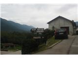
Starting point: Magozd (450 m)
Route name: Stefka's Path
Walking time: 5 h 30 min
Difficulty: partly demanding unmarked way
Elevation gain: 1318 m
Elevation difference along the route: 1415 m
Map: Quo 25K, Julijske Alpe - zahodni del 1:50.000
Recommended equipment (summer): helmet
Recommended equipment (winter): helmet, ice axe, crampons
Views: 19.288
 | 6 people like this post |
Access to starting point:
We drive to Magozd from the direction of Drežnica and then, when the asphalt ends, drive a further 300 m on macadam and park under a bushy linden tree (it is worth parking so that the car will be in the shade upon return).
Route description:
From the starting point, we go on macadam in the direction of Trnovo (ob Soči). After a little less than 500 meters we turn slightly to the right on a grassy path. And soon thereafter once again on the right branch. We are on a mule track, which leads us to the top. Mostly through the beech forest, where views will continually open up on Soča and Trnovo.
After 1,600 meters from the beginning of the path, we find ourselves in front of the torrent Globoščak, which we cross and on the opposite bank look for the continuation of the path. It leads upwards all the time. At an altitude of 1,100 m, on our left by the path, the hunting cottage LD Drežnica appears, firmly attached to the rock. In front of the hunting cottage there is a rocky ledge with a nice view of the Soča valley and the village of Trnovo.
At an altitude of 1,200 m we exit the forest. To the mountain pasture Dolec we must overcome another 200 m of elevation gain. The entrance to the mountain pasture Dolec offers a nice view of Pirhovec (1,663 m) on the left, Veliki vrh (1,764 m) on the right. Here we were witnesses to a rare scene of a flock of hawks flying over. First six and then four more behind them. They glided peacefully from the direction of Krasji Vrh (1,768 m) to Veliki Polovnik (1,471 m).
In preparing the path, we relied on aerial photos, which very clearly show the course of the path across the mountain pasture Dolenc.
However, in August the vegetation is so lush, and visitors so rare, that we often only sense where the mule track runs. We cross it several times also because at some places it is densely overgrown with low beech trees, where many trees are literally laid horizontally, and clambering over trunks and clearing tough branches is quite strenuous work.
Veliki vrh rewards us with a wonderful view of the amphitheater of the Bovec mountains. Visibility is just good enough for the view to reach Triglav, which is a little more than 22 kilometers away.
Just before the start of the descent we notice that the hawks are returning. They fly much lower, some right by the rocks, lower than us. A truly beautiful sight of gliding giants that measure more than 2 meters across the wings. Hungry looks are also noticeable; they are surely hungry. The sight of them by the precipitous wall below the summit evokes a feeling of unease. The path downward more exposedly reveals some spots where the trail above the steep slope narrows considerably.
The use of hiking poles is very useful.
For the path to Veliki vrh we needed a good five and a half hours. The calculation showed that our physical fitness index is 30. "Gamsi" with a fitness index of 15 would need a good three and a half hours for this path.
Here is also a PDF file available: http://www.globalvision.si/hribi_net/Veliki_Vrh_stefkina_pot.pdf

Photos:
 1
1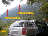 2
2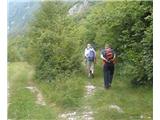 3
3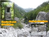 4
4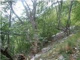 5
5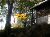 6
6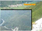 7
7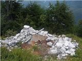 8
8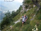 9
9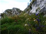 10
10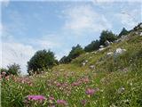 11
11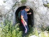 12
12 13
13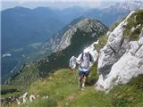 14
14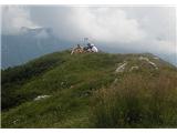 15
15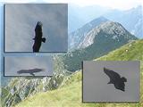 16
16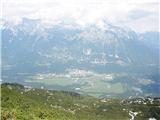 17
17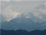 18
18
Discussion about the trip Magozd - Veliki vrh (Polovnik) (Stefka's Path)
|
| husky20. 08. 2009 |
The pasture is called Dolec, or "Douc" in Drežniško. It is possible to do a circular tour as well - from Magozd along the hunting or shepherd path to the ridge between Krasji and V. vrh and return via the described path over planina Dolec.
|
|
|
|
| dusko2320. 08. 2009 |
Thanks Husky, could you roughly mark the course of the hunting or shepherd path on the map posted in the topic under General discussions, Quo - interactive Slovenia, so we can explore it.
Thanks for pointing out the typing (or reading) error. Do you perhaps know how to correct a published article. 
|
|
|
|
| atoamac10. 05. 2011 |
Among the recommended equipment, you can safely include a helmet, especially if the trip is planned for a larger group. Otherwise, a beautiful tour for pre-summer and late autumn periods.
|
|
|
|
| keti120. 03. 2012 |
Does anyone know if there is still any snow on the path from Magozd via mulatiera to Veliki vrh - Krasji vrh - Drežniške Ravne?
|
|
|
|
| ljubitelj gora1. 07. 2018 |
Walked the described route on 1.7.2018 and continued to Krasji vrh, descent along the marked path back to Magozd.
|
|
|
|
| ljubitelj gora2. 07. 2018 |
1300 m elevation gain means about 4 hours of normal walking.
|
|
|
|
| B22. 07. 2018 |
I walked this path a few years ago, but in the opposite direction. It seems to me that there is also a hunting hut on the edge of Planina Dolec (on the opposite, northern side of the planina edge). Due to lack of time, I couldn't explore the terrain and caverns on the planina. I'm interested if anyone knows whether it is possible to overnight there (in the hunting hut on Planina Dolec)? I would need this info for crossing Polovnik, which I am planning. The tour is extremely long, and the starting point and goal are also very remote.
|
|
|
|
| Mlibo29. 07. 2018 |
I'd like to go from Log čezsoški to Polovnik (Veliki vrh - planina Polovnik) and back to Log. Maybe someone knows this trail and can advise what the trail is like, if it's trodden enough to follow, duration, possible dangers or peculiarities. I'm 60+ so please real data and appropriate advice. LP
|
|
|
|
| B229. 07. 2018 |
Mlibo, I hope someone will "dare" and reveal the "secret". Once I explored the terrain around there myself. On the Bovec 1:25 000 map, there are drawn mulatieres, which are indeed overgrown, but can be followed and are well visible from in front of the inn in Žaga. Also the mulatiera well visible from the Srpenica - Žaga road is good and passable (even though the guidebook says it's unusable) and leads us to the former military settlement on the western shoulder of Polovnik, I didn't go further, but it's drawn on the map and can be nicely followed and usefully used. If we "break through" to Travnik (first peak in Polovnik from the west) we've won. But in this season, there are huge numbers of snakes in the entire Polovnik area, large nose-horned vipers and black-colored adders hiding in tall grass...
|
|
|
|
| iUnknown30. 07. 2018 |
If it helps you by chance, here I found a GPX track from someone who went from Log to Polovnik.
https://www.gpsies.com/map.do?fileId=kdjfztxhtelaomxk
But take it with reserve, because sometimes people who publish this have poorer GPS devices.
I would also be interested in some exploration.
|
|
|
|
| raubšic30. 07. 2018 |
The path does not exist or is not suitable for 60+.
|
|
|
|
| B230. 07. 2018 |
Go from Log Čezsoški down about 500 meters along the nice gravel road by the Soča and at the remains of the concrete structure on the left side of the path you will come across a poorly visible start of a nice mule track that gently ascends the slope. You will start walking at 400 m a.s.l. and at around 650 m a.s.l. notice the remains of the former pasture on the right. Here the path turns sharply left. You have nice views of the valley below and the Soča River all the time. At around 1100 m a.s.l. the mule track will somewhat get lost in the tall grass, here you will also encounter remains of military structures from World War I. The place is called Na požarju. Continuing, you need to search for the remains of the mule track coming from Log Čezsoški in the tall grass and continue right up the steep slope. I went this far, but not further. As far as I saw, the path is traceable with a little care. Otherwise, Polovnik is little visited and consequently the paths are less trodden. Really a pity, because there are many mulatieres in this area, as the Italians left us quite well-built military paths here that we can use to good advantage. I myself am 60+, not to be discarded, but I wouldn't tackle Polovnik in this heat, rather more in autumn and I will certainly do so... Otherwise, I hiked the route Drežnica - Zapleč - Krasji vrh - Veliki vrh - Planina Dolec - Magozd - Drežnica. That was last October. It's a full day's walk. It would be nice if one could overnight somewhere along the way.
|
|
|
|
| iUnknown30. 07. 2018 |
I thought it would be best to tackle this once late autumn, when there will be neither snow, tall grass, nor ticks  Maybe someone knows when there are no more ticks? Maybe someone knows when there are no more ticks?
As for overnighting, in my opinion it's not even necessary, because the path doesn't look very long, 15.6 km around Pirhovec, nor is the total elevation gain large. Only 1700m.
If overnighting were necessary, you can take a small tent with you. I have one that weighs only 1600g.
|
|
|
|
| Mlibo30. 07. 2018 |
Thanks for the help. I'll head out on the path when it's a bit less hot. If it ends successfully, I'll let you know. LP
|
|
|
|
| Mlibo31. 08. 2018 |
 "On 9.8.2018 it was suitable weather for visiting Polovnik. For the path I partly used the track sent to me by iUnknown (thanks), a bit I went my own way. Since there are many mulatieres in this area, orientation which is the right mulatiera is a bit difficult, but the goal can be reached. I reached the Polovnik ridge at the saddle between Pirhovec and Špik then continued Nad Pečem, planina Polovnik, Vrh travnika, Veliki Polovnik and to Log. The descent from the summit is easy, as it follows a well visible mulatiera. The path is harder to follow on grassy terrain than in the forest, where there are many game trails that can be mistaken for a hiking path. Along the path there are also quite a few "cairns" (now there are even more), which at least somewhat facilitate orientation, but I would advise hikers not to set them up unnecessarily and in wrong places. For the entire path I used a little less than 9 hours, during which I got a bit lost a few times even with the help of cairns, which suddenly ran out. "On 9.8.2018 it was suitable weather for visiting Polovnik. For the path I partly used the track sent to me by iUnknown (thanks), a bit I went my own way. Since there are many mulatieres in this area, orientation which is the right mulatiera is a bit difficult, but the goal can be reached. I reached the Polovnik ridge at the saddle between Pirhovec and Špik then continued Nad Pečem, planina Polovnik, Vrh travnika, Veliki Polovnik and to Log. The descent from the summit is easy, as it follows a well visible mulatiera. The path is harder to follow on grassy terrain than in the forest, where there are many game trails that can be mistaken for a hiking path. Along the path there are also quite a few "cairns" (now there are even more), which at least somewhat facilitate orientation, but I would advise hikers not to set them up unnecessarily and in wrong places. For the entire path I used a little less than 9 hours, during which I got a bit lost a few times even with the help of cairns, which suddenly ran out.
I tell Raubšic, where there's a will there's a way even for 60+ .
|
|
|
|
| B231. 08. 2018 |
Bravo Mlibo! So the paths (mulatieres) exist! You found out that they are usable, as I wrote and in good condition and not as "raubšic" claims. If I'm not mistaken, this same "raubšic" once claimed that there is no path on Rombon either. And how many there are and good mulatieres at that! I don't know why such jealousy? Let people walk and enjoy the beauties of the mountains and learn about the history of the First World War. There will be enough game for hunters anyway... I'm also interested where the name Štefkina pot comes from? In my opinion, it was an old access path to planina Dolec and later "converted" into a mulatiera. Otherwise, perhaps in ancient times there really was some shepherdess Štefka on planina Dolec...
|
|
|
|
| ljubitelj gora1. 09. 2018 |
Just FYI, parking under the linden tree is meant next to the playground. No point going further by car.
|
|
|
|
| darekoporcic26. 09. 2018 |
I'm not yet 60+, but I know that many at 40+ are capable of less than others at 60+. So that comment about the suitability of the path was rude and completely useless.
|
|
|
|
| mirank26. 09. 2018 |
My late colleague always said that he was still worth two poor young ones. Now I console myself the same way
|
|
|
|
| darinka43. 05. 2020 |
Interesting. The walking time of 5 hours seems quite a lot to me, given no excessive elevation. Haven't hiked here yet.
|
|
|
|
| darinka44. 05. 2020 |
Today walked the ridge. We started in Magozd. I left the car under the mighty linden tree. Interesting trail, mulatiera. Well visible to the junction for Pirhovec, where two hikers went. We then steeply up to Veliki vrh. From there interestingly over hillocks and along the ridge all the way to Krasji vrh and descent past Drežniške Ravne to the starting point. The watch showed 18 km and 1600 m elevation gain.
|
|
|
|
| ales505. 05. 2020 |
What are the conditions like, is there still snow up there or has it melted?
|
|
|
|
| darinka413. 11. 2021 19:54:56 |
This year we also circled from Čezsoča a couple of days ago on a new path for us. More like pathless, as time has done its work. But GPS helped us reach Pirhovec. As an interesting fact, at the top there were two women from Zagreb who also came from Čezsoča and planned to traverse the entire Polovnik ridge all the way to Drežniške Ravne. Marijan described the path to them that we had hiked not long ago. Our descent was quite interesting on the new path at least for us to the village Log Čezsoški and then another 5 km in the dark to Čezsoča. The Zagreb women reported back in the following days. They succeeded in traversing the entire ridge. In Drežniške Ravne a local drove them to the car they had in Log Čezsoški. So age doesn't matter when it comes to hiking. Much more important is physical fitness.
|
|
|
|
| winni16. 11. 2021 12:48:05 |
Directly from Čezsoča to Pirhovec or via Log Čezsoški? Which is this new path here?
|
|
|
|
| darinka416. 11. 2021 13:38:44 |
Yes from Čezsoča. The start of the path is not visible. This path is drawn on old maps. And sometimes poorly visible or not there at all. In general, poorly traceable. Below Pirhovec we found a path that leads to planina Dolec past the hunting hut. We went up steeply and pathless to the top of Pirhovec before. The new path was meant for us when we descended to Log Čezsoški. The path descends further from the planina on Polovnik to the right and turns into the forest.
|
|
|
|
| winni17. 11. 2021 13:06:26 |
Interesting, every time I'm in Bovec I wonder why there's not even one path leading to the Polovnik ridge  Where exactly does it start in Čezsoča? Where exactly does it start in Čezsoča?
|
|
|
|
| darinka417. 11. 2021 13:52:05 |
See my post Polovnik. First along the forest path. Where the cableway was once laid. Now only remains are there. We didn't find the start of the path right away. We searched a bit because it's no longer visible. Then quite traceable. On some sections it wasn't there. And some difficult passages on all fours were needed. And it's steep all the way. When searching where the path should go, the walking time extends. I think we searched for passages three times where the path should go. We needed about 5 hours to the top of Pirhovec. Which is not little. But if you go from Log Čezsoški steeply above the village, there's a traceable little path. The one we descended on is quite steep for ascent but much more visible than ours from Čezsoča.
|
|
|
|
| sezana117. 11. 2021 22:39:41 |
If you look from the airport you can orient by the group of spruces under the rocks of Polovnik. You reach this group of spruces along the forest road from Čezsoča (also by vehicle to the barrier) and before the ski slope cut and on the left look for the roadside concrete ditch for water drainage. Here is also the aforementioned group of spruces and in the little forest a concrete bunker from the First World War. Nearby in the rocks starts the much sought-after very steep path that ends at planina Dolec. If you look well, you can easily notice very faded red lines with which the start of this path is marked on the rocks.
But the path is poorly traceable and very steep...
|
|
|
|
| winni19. 11. 2021 14:38:21 |
Has anyone gone along the mule track that starts somewhere halfway on the path from Log Čezsoški towards Srpenica? In winter months it's clearly visible, at least the beginning, but I don't know how it is higher up under the summit. There's no GPS track on Strava either...
|
|
|
|
| turbo19. 11. 2021 19:13:24 |
I went along that mule track sometime between 1997 and 2005, approximately. Twice. First time only to the hunting hut between Mali and Veliki Polovnik, second time a year later traversing the entire ridge with descent past Planina Predolina and from there along Slatenik to Čezsoča. I remember that the mule track was easy to follow high under the ridge, higher up it was less distinct. But that's so long ago that it's certainly different today.
|
|
|
|
| sezana120. 11. 2021 11:00:17 |
winni, hello! Check the posts from 2018. A century has passed since the mule tracks on Polovnik were made and they are still useful and easy to follow. They will be like that even when we're gone. In the three years since the above posts, nothing has changed much, or nothing at all. Just happily on the way...
|
|
|
|
| darinka430. 04. 2022 18:28:46 |
On the last day of April, Maks and I headed to Pirhovec. In the morning from Magozd along the known path. Almost no snow left on the path. From planina Dolec we went up directly off-trail. The path goes quite around. At the top there were about eight hikers. Beautiful day.
|
|
|
|
| darinka419. 06. 2023 21:35:43 |
We three had a nice ridge tour from Magozd over Veliki vrh, Krasji vrh and descent past the basin along the path that branches off a bit further to the car in Magozd. Nice Monday.
|
|
|
|
| jax20. 06. 2023 08:01:35 |
Yes, that's crossing half of Polovnik. Nice and easily doable tour. The whole ridge is logistically impractical.
|
|
|
|
| darinka420. 06. 2023 08:07:27 |
Yes really. But some manage to hike the entire ridge. Last year we met two Croats on Pirhovec who did it in one day. But we preferred to split it into two parts, which makes sense. Yesterday it was already about 18 km of walking. And quite some elevation gain. I've done this part three times. Worth it. Scenic ridge path.
|
|
|
|
| mirank20. 06. 2023 11:28:09 |
I see no problem, we left the car at the bridge over Soča. An acquaintance from Žaga took us to D level to the basin for 20eur and start at 7am. At 2pm we were in Log čezsoški. Admittedly the pace on the ascent to K vrh was killer but then the crossing was normal walking
|
|
|
To post a comment you must log in:
If you do not yet have a username, you must first
register.