Lovrenc na Pohorju - Rogla
Starting point: Lovrenc na Pohorju (436 m)
| Latitude/Longitude: | 46,54195°N 15,38604°E |
| |
Walking time: 4 h 30 min
Difficulty: easy marked way
Elevation gain: 1081 m
Elevation difference along the route: 1130 m
Map: Pohorje 1:50.000
Recommended equipment (summer):
Recommended equipment (winter): ice axe, crampons
Views: 1.310
 | 2 people like this post |
Access to starting point:
A) From the road Maribor - Dravograd, between HE Fala and HE Ožbalt we turn left towards Lovrenc na Pohorju (from the direction of Dravograd we turn right). On the other side of the Drava we start ascending along Radoljna, and at the marked intersection we go slightly right on the main road towards Lovrenc na Pohorju. When we arrive in the settlement Lovrenc na Pohorju we follow the main road, and in the center of the settlement we turn right towards the primary school, where we park on the parking lot by the school. We can also park elsewhere in the settlement, where there are several arranged free parking spots.
B) We drive to Ruše, and then we follow the road towards Lovrenc na Pohorju. In the settlement Činžat we arrive at a pass, where the road starts descending, and lower we go left towards Lovrenc na Pohorju. When we arrive in the settlement Lovrenc na Pohorju we follow the main road, and in the center of the settlement we turn right towards the primary school, where we park on the parking lot by the school. We can also park elsewhere in the settlement, where there are several arranged free parking spots.
Route description:
From the parking lot we return to the center of the settlement, then we ascend along the main road towards the southwest. After a few minutes we arrive at a marked intersection, where we continue left in the direction of Klopni vrh and Pesek. A gentle descent follows, when the road turns right we again start lightly ascending. The path ahead leads us past the filial church of St. Radegund, where there is also a parking option. We continue on the sidewalk, when the sidewalk ends we go right onto a side road, along which we quickly arrive at another road, which we follow to the right. We then walk past the last houses of the settlement Lovrenc na Pohorju, and the road turns into the gorge of the stream Radoljna.
On the part where the gorge narrows a marked path branches off to the left towards Klopni vrh, and we continue slightly right and keep walking on the asphalt road. Higher we pass the refreshment spot Sgerm, at intersections we follow the signs for Pesek. Eventually we leave the valley of Radoljna and arrive in the gorge of the stream Plešiščica, where we pass MHE Lakožič. We walk along the asphalt road to the left bend, where the blazes direct us straight onto a cart track that continues along the stream.
Immediately after leaving the road the cart track splits, and we continue on the right, less pronounced one, which continues along the stream. For a few minutes we lightly ascend along the right bank of the stream, then we cross it over a footbridge, where extra caution is needed. On the other side we follow the blazes, after a few minutes we reach a macadam road, which we follow to the left. After a few minutes of easy ascent the road takes us back to the right bank of the stream, and we leave it just a few steps after the bridge and continue right onto the marked path. A somewhat more overgrown path follows, where at several junctions we follow the blazes, and the path also moves a little away from the quite noisy stream. We then go through a section overgrown with young spruces, after which we quickly reach a forest road, which we follow to the right. When we notice a wooden hut ahead we go left off the road, bypassing the hut on the left side and ascending briefly along a smaller stream. A bit further, at the edge of the forest the path turns right and enters the forest, where we continue on a wider cart track and follow it in the direction of the blazes at junctions. Some ascent through the forest follows, after which we cross a forest road and continue through the forest again. When a few minutes higher we step onto the road again we follow it to the right. We walk a few minutes on the road, then go slightly left onto a steeper cart track that begins to ascend transversely, at several junctions as usual we follow the blazes. Higher the path levels out and in a few minutes we arrive at a wider macadam road, where there is a marked junction and road intersection.
We choose the right road that leads towards Koča na Pesku and Rogla, when the road turns somewhat to the left we leave it and at the poorly marked junction continue straight onto the cart track. Along the cart track we ascend more steeply, at numerous junctions we carefully follow the blazes. Higher the path levels out, in the area named Kocafurova koča it turns left, where it continues for a few minutes with some shorter ascents and descents. Later some moderate descent follows and when we leave the forest we arrive at Koča na Pesku.
From Koča na Pesku some ten meters we continue on the asphalt road towards Rogla, then we continue right onto a cart track in the direction of Rogla. We continue for some time on the gentle cart track, then immediately after crossing a smaller stream we continue left onto a somewhat steeper footpath, which then ascends through the forest. Higher the trail gradually levels out and brings us into a gradually thinner forest. From the point where the forest thins out only a short walk separates us from the lookout tower on Rogla.
If there is no danger of storms, we can climb the mentioned tower on our own responsibility, from which a nice view opens up over a larger part of Pohorje, and with good visibility also on the Karawanks, Kamnik-Savinja Alps and Triglav.
Lovrenc na Pohorju - Koča na Pesku 4:00, Koča na Pesku - Rogla 0:30.

Photos:
 1
1 2
2 3
3 4
4 5
5 6
6 7
7 8
8 9
9 10
10 11
11 12
12 13
13 14
14 15
15 16
16 17
17 18
18 19
19 20
20 21
21 22
22 23
23 24
24 25
25 26
26 27
27 28
28 29
29 30
30 31
31 32
32 33
33 34
34 35
35 36
36 37
37 38
38 39
39 40
40 41
41 42
42 43
43 44
44 45
45 46
46 47
47 48
48 49
49 50
50 51
51 52
52 53
53 54
54 55
55 56
56 57
57 58
58 59
59 60
60 61
61 62
62 63
63 64
64 65
65 66
66 67
67 68
68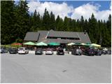 69
69 70
70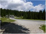 71
71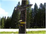 72
72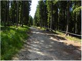 73
73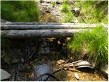 74
74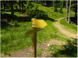 75
75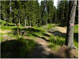 76
76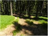 77
77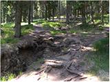 78
78 79
79 80
80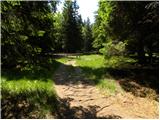 81
81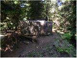 82
82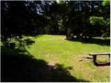 83
83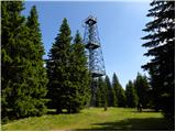 84
84 85
85 86
86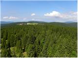 87
87 88
88
Discussion about the trip Lovrenc na Pohorju - Rogla
|
| mado16. 05. 2022 17:08:53 |
Yesterday 15.5.2022 we went from Lovrenc to Rogla. We parked by the school and then walked almost 4km on asphalt. Advice is to park somewhere closer, much higher up, even by the mini hydroelectric plant, just don't know if it's allowed. There are definitely spots along the road.
Otherwise the trail is very good, markings excellent all the time and clearly visible. We also used LocusMaps and navigated easily. More than half the trail passes near one of the numerous streams with countless waterfalls  almost the whole day we had relaxing water sounds. almost the whole day we had relaxing water sounds.
Uphill took about 6h as we are out of shape.
Total walking 8-9h (whole trip about 11h). Covered about 25km with about 1100m elevation gain.
Saw 1 chamois at about 700m altitude. Didn't know there were any on Pohorje.
Beautiful trip, highly recommend it
|
|
|
To post a comment you must log in:
If you do not yet have a username, you must first
register.