Log v Bohinju - Grmečica waterfall
Starting point: Log v Bohinju (500 m)
| Latitude/Longitude: | 46,2875°N 13,9798°E |
| |
Walking time: 20 min
Difficulty: easy marked way
Elevation gain: 10 m
Elevation difference along the route: 10 m
Map: TNP 1:50.000
Recommended equipment (summer):
Recommended equipment (winter):
Views: 12.953
 | 2 people like this post |
Access to starting point:
From the highway Ljubljana - Jesenice, we take the exit Lesce and follow the road towards Bled and further towards Bohinjska Bistrica. Just before Bohinjska Bistrica, we will notice signs for the village Log, which is the starting point for our tour (at the starting point, there are no designated parking spaces).
Route description:
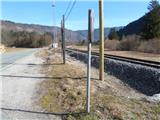
At first, we walk through the village and at the end of it we turn left onto a cart track which crosses a larger meadow. A pleasant cart track path which then runs through the forest, then continues along the river Sava Bohinjka, from which it then moves a little to the right. There follow only a few minutes of walking and the path will bring us to the waterfall Grmečica.
The author of the pictures below is the user Pi_is_exactly_3.
Photos:
 1
1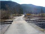 2
2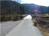 3
3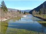 4
4 5
5 6
6 7
7 8
8 9
9 10
10 11
11 12
12 13
13 14
14 15
15 16
16 17
17
Discussion about the trip Log v Bohinju - Grmečica waterfall
|
| Gost24. 07. 2007 |
JULY 2007:
THROUGH VAS LOG THE WATERFALL IS HARD TO ACCESS OR RATHER "INACCESSIBLE",
BECAUSE THE OWNERS OF THE HOUSE NEXT TO WHICH THE CART TRACK RUNS HAVE CLOSED THE PATH WITH A FENCE.
CROSSING TO THE WATERFALL THROUGH PASTURES AND MEADOWS I DISADVISE DUE TO MY OWN BAD EXPERIENCES WITH THE OWNERS OF THESE LANDS.
WHOEVER TRIES TO "BREAK THROUGH" TO THE WATERFALL ALONG THE ABOVE-DESCRIBED OLD PATH PAST ANGRY AND QUARRELSOME VILLAGERS OF LOGA DESPITE "DIFFICULT CONDITIONS ON THE PATH", I WISH MUCH LUCK AND INGENUITY, WILL BE WELL REWARDED AT THE END FOR THEIR PERSISTENCE AND EFFORT 
|
|
|
|
| cico17. 03. 2016 |
Never had problems with locals from Log, they even invited us for lunch once! You have to understand these people,
city dwellers would prefer to drive right to
the waterfall and have picnics there! We can avoid it all in two ways, before the bridge at the end of Soteska drive another 1 km, then
walk along the narrow concreted road and a bit on the forest trail, and we're there! Second option
is the newer hanging bridge before Nomenj village, cross Bohinjka back to that
concrete forest road, a bit through the woods, and we're there! If low water in summer, ford Bohinjka at Nomenj,
park at the bus stop!
Grmečica Gorge is among the harder canyons
around here, tourists are guided on the lower part,
I needed almost 7 hours for the whole from Nemški Rovt or holcplac, and I
didn't jump the waterfall due to exhaustion!
Lots of waterfalls, pools, once you enter no way out, crazy wilderness, pristine beauty,
I admit I wouldn't dare alone anymore, only with company! I also recommend viewing the big
rapid, turn left before the bridge along
Bohinjka when water gushes from Jelovica, insane!!
If anyone wants more details, find me
via ZS, that's it for now, best regards!!
|
|
|
|
| cico17. 03. 2016 |
Possible that the situation has now changed somewhat, I did that 10 years
ago , where is my youth , where is my youth
|
|
|
|
| KarmenT7. 07. 2022 19:35:21 |
On 2.7.2022 we cycled from Bohinjska Bistrica to the village of Log and along the path described above to the waterfall, which has dried up. Locals were just felling trees around there and said it would come back to life with the first major rain. We continued to the movable bridge in the village of Nomenj, crossed it and returned to BB.
|
|
|
To post a comment you must log in:
If you do not yet have a username, you must first
register.