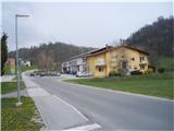
Starting point: Lesično (311 m)
| Latitude/Longitude: | 46,1016°N 15,5193°E |
| |
Walking time: 1 h 45 min
Difficulty: easy marked way
Elevation gain: 549 m
Elevation difference along the route: 549 m
Map: Posavsko hribovje Boč - Bohor 1:50.000
Recommended equipment (summer):
Recommended equipment (winter):
Views: 3.362
 | 4 people like this post |
Access to starting point:
A) Dramlje exit on the highway and through Šentjur to Lesično
B) From the direction of Podčetrtek through Golobinjek, Virštanj to Lesično.
C) From the direction of Bistrica ob Sotli, Podsreda and Kozje to Lesično
D) From the direction of Brestanica, Senovo, Podsreda and Kozje to Lesično.
Route description:
In the settlement Lesično, where we park at the beginning of the path by the bridge over the stream Bistrica. The mountain path to Brest is also the XIV Division trail. The path leads on forest paths and roads. It is excellently marked. In Brest we go left slightly downwards on the forest road in the direction of Podsreda - castle, after a good hundred meters at the first turn-off once again left on the forest road and further on a cart track upwards we reach the peak of Oslica.
Photos:
 1
1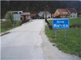 2
2 3
3 4
4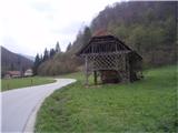 5
5 6
6 7
7 8
8 9
9 10
10 11
11 12
12 13
13 14
14 15
15 16
16 17
17 18
18 19
19 20
20 21
21 22
22 23
23 24
24 25
25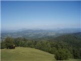 26
26
Discussion about the trip Lesično - Oslica (Bohor)
|
| šoni5. 12. 2016 |
FROM BRESTA THE PATH GOES LEFT SLIGHTLY UPWARDS (NOT DOWN)
TOWARDS OSLICA, EXACTLY OPPOSITE TO THE PATH TO THE HUT ON BOHOR, THE GIVEN DESCRIPTION DIRECTS LEFT ALONG THE MAIN ROAD DOWN FROM BRESTA.
|
|
|
|
| bruny5. 12. 2016 |
My description is correct, good hundred meters the path/road goes downhill...it's visible already from picture no.22...from picture no.23 it's left uphill...
|
|
|
|
| Stamp17. 01. 2019 |
For slightly stronger adventurers, on the link there is a circular trail from Lesično.. Oslica (circular)
|
|
|
To post a comment you must log in:
If you do not yet have a username, you must first
register.