Laško (obračališče nad vasjo) - Storžič (via Kališče)
Starting point: Laško (obračališče nad vasjo) (815 m)
| Latitude/Longitude: | 46,3298°N 14,3988°E |
| |
Route name: via Kališče
Walking time: 3 h 20 min
Difficulty: difficult marked way
Elevation gain: 1317 m
Elevation difference along the route: 1320 m
Map: Karavanke - osrednji del 1:50.000
Recommended equipment (summer):
Recommended equipment (winter): ice axe, crampons
Views: 120.585
 | 4 people like this post |
Access to starting point:
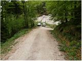
a) From the Ljubljana - Jesenice motorway, take the Kranj - east exit, then continue driving towards Jezersko. Upon arriving in Preddvor, leave the main road and continue left towards the centre of the mentioned town, from there follow the signs for the Bašelj settlement. When arriving in Bašelj, at the beginning of the left bend a narrower road continues straight ahead to the parking lot at the TD Bašelj log cabin (in descriptions starting point Bašelj), we however continue along the main road from the mentioned intersection for another good 100 m to the next intersection, where we turn right onto the road towards Gamsov raj and the Laško hamlet. About 50 m further, take the left road, which gradually begins to rise moderately. At the Laško hamlet, turn left again, then the asphalt ends and we continue on a steep gravel road that leads past the junction of the path (track) to the church of St. Lovrenc and Dom na Lovrencu. From the mentioned junction, drive a little further to the end of the road or a smaller parking lot some 10 metres before.
b) From the Jesenice - Ljubljana motorway, take the Kranj - west exit and at the first intersection turn left. Continue through the underpass under the motorway, then arrive at a roundabout, from which continue driving towards Golnik. The road ahead leads through the settlement of Mlaka pri Kranju, at the end of the settlement turn right towards the Srakovlje settlement. Follow the road through Srakovlje, Spodnja Bela, Srednja Bela, Zgornja Bela (in Zgornja Bela we join the road from Preddvor) to Bašelj, where the main road makes a long left bend, where a narrower road continues straight ahead to the parking lot at the TD Bašelj log cabin (in descriptions starting point Bašelj), we however continue along the main road from the mentioned intersection for another good 100 m to the next intersection, where we turn right onto the road towards Gamsov raj and the Laško hamlet. About 50 m further, take the left road, which gradually begins to rise moderately. At the Laško hamlet, turn left again, then the asphalt ends and we continue on a steep gravel road that leads past the junction of the path (track) to the church of St. Lovrenc and Dom na Lovrencu. From the mentioned junction, drive a little further to the end of the road or a smaller parking lot some 10 metres before.
Route description:
From the small parking lot, walk to the turning circle at the end of the road. From the end of the road, continue left onto the track towards Kališče and Storžič. The track then rises moderately along the bed of the Belica stream and after about 10 minutes splits into two parts. Continue on the left track, which ends after a few metres. Here, leave the proximity of the stream bed and continue slightly left on the path that steeply ascends through the forest. The steepness soon eases and the path leads us to the partisan hospital Košuta.
After the hospital, cross two consecutive gullies, then the path becomes steeper again. The path ahead still continues through the forest, crossing a steeper slope where extra caution is needed in wet conditions. Above the steep section, reach the side ridge of Kališče, where an unmarked path from Bašelj joins from the right.
Here, continue left and continue the ascent on the still steep path that proceeds through increasingly sparse forest. After a bench and some views of nearby Storžič, the path turns right and returns to dense forest. A less steep path follows, which quickly takes us to the first hut on Spodnje Kališče. After the hut, the forest ends, then along a pleasant grassy base in a few minutes we reach the central part of the pasture, where we also join the usual path from Mač.
From Spodnje Kališče, continue slightly left towards Dom na Kališču, from which a few minutes of walking through the forest follow, then we arrive at a beautiful viewpoint from which a nice view opens towards the nearby Dom na Kališču, Mali Grintovec, the ridge of Lanež, Krvavec... From the viewpoint, only a short ascent follows and we are at Dom na Kališču.
Behind Dom na Kališču, notice the mountaineering signpost with numerous route continuation options. Continue along the gentle and scenic ridge path towards Storžič, Bašeljski vrh..., which proceeds northwards. After a few minutes of easy walking with beautiful views reaching to the Julian Alps, arrive at a junction where the path to the church of sv. Lovrenc above Bašelj, planina Javornik and Kriška gora branches left, the path to Bašeljski vrh and Mali Grintovec branches right, we continue straight towards Storžič. A few minutes of traversing mostly the western slopes of Bašeljski vrh follow, then arrive at the grassy Bašeljski preval, where the path from Jezersko joins from the right (in descriptions starting point Jekarica).
Again continue straight towards Storžič, this time on a path that begins to steeply ascend through a belt of dwarf pines. After about 30 minutes of ascent from the saddle, step onto the ridge of Storžič, which we soon leave as the path switches to the southern slopes of the mountain. Over fairly steep southern slopes, we ascend on a steep path that is slippery in several places, especially when wet. Higher up, the path levels slightly and returns to the ridge, along and on which it then continues. To the increasingly scenic path, just below the summit, paths from sv. Lovrenc, planina Javornik, and the path over Psica and through Žrelo join from the left. Here, continue slightly right and in a few steps reach one of the most visited two-thousanders in Slovenia.
Starting point - Partisan hospital Košuta 0:25, Partisan hospital Košuta - Kisovec 0:25, Kisovec - Planina Kališče 0:45, Planina Kališče - Dom na Kališču 0:15, Dom na Kališču - junction on Kališče 0:10, junction above Kališče - Bašeljski preval 0:10, Bašeljski preval - Storžič 1:10.

Photos:
 1
1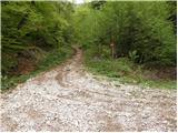 2
2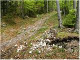 3
3 4
4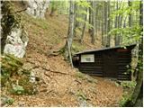 5
5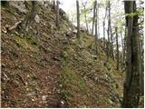 6
6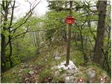 7
7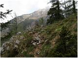 8
8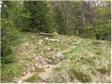 9
9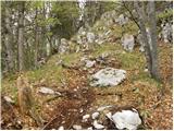 10
10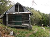 11
11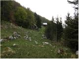 12
12 13
13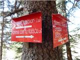 14
14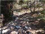 15
15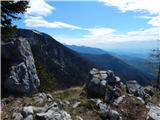 16
16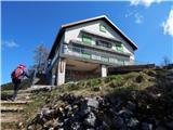 17
17 18
18 19
19 20
20 21
21 22
22 23
23 24
24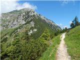 25
25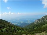 26
26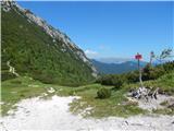 27
27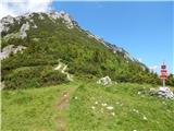 28
28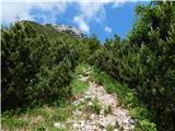 29
29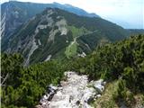 30
30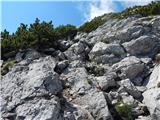 31
31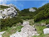 32
32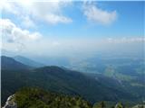 33
33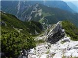 34
34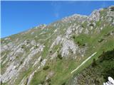 35
35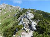 36
36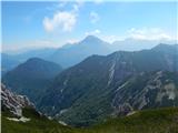 37
37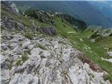 38
38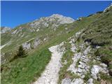 39
39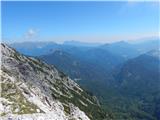 40
40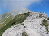 41
41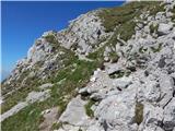 42
42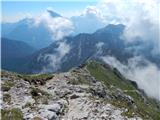 43
43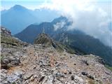 44
44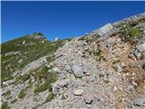 45
45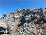 46
46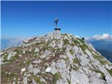 47
47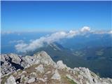 48
48 49
49
Discussion about the trip Laško (obračališče nad vasjo) - Storžič (via Kališče)
Show older messages
|
| Gost21. 06. 2007 |
Very nice trip, but terribly many flies (I've never seen so many). I would just warn that the trail is not so easy for inexperienced hikers, as the rocks are quite steep. I mention this because we met quite a few poorly equipped hikers on the trail (bad footwear, no extra clothing etc.), at very late hours (when it was already thundering). So I warn those who are not used to walking in the mountains - Storžič is still high mountain terrain and preparation is not superfluous. june2007
|
|
|
|
| Gost7. 11. 2007 |
What are the conditions like on Storžič?
LP
|
|
|
|
| Karletto7. 11. 2009 |
I got up there with my last atoms of strength 
|
|
|
|
| pantani7. 11. 2009 |
Karletto, obviously you went after me, because I had to turn back here at 1860m, simply in this southern snow and occasional drifts it was no longer possible to go further.
I deviated a bit from the path, because I went first today and the snow is really heavy.
Anyway.
LP
|
|
|
|
| mabone30. 12. 2009 |
Yesterday I was up there. Nice weather, upper part frozen. Without crampons I don't know how it would go,
|
|
|
|
| BACEK JON23. 05. 2010 |
This morning on Storžič (Laško-Kališče-Storžič), weather gorgeous, quite a few people, path completely dry, LP.
|
|
|
|
| apovalej27. 02. 2011 |
Today on Storžič, very nice weather.
From home at Kališče, crampons recommended on some spots but completely snow-free in places and crampons become a bit annoying
|
|
|
|
| stezosledka1. 04. 2011 |
30.3.2011 we were on Storžič from Bašelj (St. Lovrenc) via a very steep unmarked ridge path. It is almost dry (watch out only for slippery grass!) Dreamy weather and view from the top! On the descent to Kališče there is still quite a bit of snow, it can sink up to the waist, and it freezes in the evening. Essential winter gear! Matej, Juš and Borut, thanks for the company and guidance! Again sometime! 
|
|
|
|
| Kozorog2. 04. 2011 |
stezosledka (good nickname) but choose another tour with your girlfriend that you can handle!!! instead of waiting for a rescuer at the top... the problem is if there wasn't one....
|
|
|
|
| JusAvgustin3. 04. 2011 |
no, today we didn't meet stezosledka...
|
|
|
|
| roml9. 05. 2011 |
Can someone tell me if there's still any snow on the path from Kališče to Storžič? Thanks and best regards!
|
|
|
|
| serajko9. 05. 2011 |
During the visit to Bašeljski vrh on Saturday, no snow was visible on the path from Kališče to Storžič
|
|
|
|
| roml9. 05. 2011 |
serajko: thanks, great, I'd like to go up, but I don't want to sink in up to my waist like a few days ago on the way to Lipanski vrh. Is there phone coverage from Kališče?
|
|
|
|
| jersy9. 05. 2011 |
the path is completely snow-free and normally passable.
|
|
|
|
| roml10. 05. 2011 |
pelican: oops, I'm silly, you just had to know how to find it.
|
|
|
|
| dolenjc14. 08. 2011 |
Today visited Storžič summit via this path. From Bašelj village (water reservoirs) to Kališče hut is a fairytale. Well, then towards summit the smile fades a bit, the path is steep, sun strong, especially downhill slip risk high. Now visible preparing cables at spots, they'll be useful esp. if wet.
Very irresponsible of dog owners dragging them on unsuitable terrain for dogs. This is high mountains....
|
|
|
|
| jurck28. 04. 2012 |
And who knows what the passability is like these days? Is there still any snow on this path?
|
|
|
|
| Dr.ejči28. 04. 2012 |
Yesterday we went along the ridge above Košuta hospital. Snow starts some 100m above Bašeljsko sedlo. It's pure slush, so we didn't need crampons, ice axe is recommended though. The path itself is a mix of rocks, grass, snow. It's walkable, not exactly for everyone though. Needs carefulness. Good luck.
|
|
|
|
| soraya11. 09. 2012 |
On Sunday, 9.9. we went to Storžič with a mountain buddy. Really nice tour to stretch a bit, just steep enough that you have to watch your step a little, otherwise super. Only too many people at the cross, I like it when there's no one around anywhere. .....no cables yet....haha .....no cables yet....haha
|
|
|
|
| dvince21. 06. 2013 |
Hi,
has anyone been up there these days?
Is there still any snow on the ridge, is it normally passable?
|
|
|
|
| cebelca21. 06. 2013 |
Was up there on Sunday, all dry, so just the path under your feet.
|
|
|
|
| Gre_Mo21. 06. 2013 |
Was up yesterday. Up via Kališče, down via Javornik. It's beautiful 
|
|
|
|
| julfi16. 11. 2015 |
Yesterday we went along this path and given the weather conditions in the previous days, the nice weather was expected, especially above 1500m, where we emerged from the fog belt. The path is varied, at times you feel like you're walking on a ladder, as it ascends quite quickly.
Recommend, LP
|
|
|
|
| dejanch16. 04. 2016 |
Hello. Question... Laško - Storžič.. Path condition... how much snow. Can't see well on the web camera..
Thanks
|
|
|
|
| rades23. 04. 2016 |
I'm also interested in the condition of the path (is it passable to the starting point) and snow conditions. Thanks.
|
|
|
|
| Kranj24. 04. 2016 |
The path has been dry for a long time!
|
|
|
|
| lala123419. 08. 2016 |
Top trip: Bašelj - Kališče - Storžič - Dom pod Storžičem. The path is excellently marked, steep just right to get a good workout on all fours in a few sections from Kališče onwards 
|
|
|
|
| PINOKIO13. 10. 2017 |
Hello!
Has anyone been to Storžič via this path in the last few days? I'm interested in how passable and marked the path is, as my friends and I plan to go up at the beginning of next week. Thanks in advance for answers and safe steps to all hikers and mountain lovers.
Tone
|
|
|
|
| Gost14. 10. 2017 |
The trail is well marked at all intersections; there are few blazes, but the path to Kališče is well trodden. From Kališče onwards, you have the goal ahead of you—just keep the path under your feet, and I wish you safe steps.
|
|
|
|
| Pekana7. 05. 2018 |
Hey! Oh my god, my girlfriend and I already ate pasulj at Kališ at eight in the morning. In between it was good, but then we were catapulted to Storžič. She said at the top, you go ahead so I can take a picture of you. I was near the cross jumping like a doe, she was laughing and taking pictures with the same mobile phone... Then we went straight down somehow, oh but the heart rate went up. Nice for about a hundred meters, the path for those interested in everything, between snowy patches at the top, the rest fine. Take crampons and ice axe but don't go up drunk, said Boudi!
|
|
|
|
| UB777. 05. 2018 |
God help us, what lies there are in our hills...
|
|
|
|
| Sandi97. 09. 2018 |
The path through Kališče is really very well signposted and marked. Extremely beautiful views from the saddle and the steepness towards the summit was quite nice. Easily conquered the whole thing even with a dog. Just as Storžič looks from the valley, it was wonderful to hike on it and conquer it.
But the summit itself surprised me, it was literally buried in sheep droppings. No way to take a step by the logbook and cross, let alone sit on something clean, no. I swear I'm not exaggerating. I appeal to the pastoral community to simply protect the summit from sheep with a pasture fence. This will make many hikers happy. Storžič itself would also DESERVE it!!! Because such a summit doesn't deserve such a beautiful mountain.
Bacek jon with the team really messed it up... shame.
|
|
|
|
| michael667. 09. 2018 |
As for the summit, Sandi said it all and didn't exaggerate. The summit has been like that for the last few years; before it was a real pleasure to sit on the summit for an hour or two. As for the marking from Laško, at the beginning it's really a crisis regarding the path past Košuta hospital. I've walked this path several times already, but this year I got completely lost. Right at the beginning, where the path splits to Kališče and past Košuta hospital, I went left towards the hospital. The trail is clearly visible at the start, then there's some fallen trees. Foresters are making new paths in the forest and felling trees with markings and signs. Somewhere there on these new paths I lost the trail and markings, so I went straight through the forest hoping to find the trail. But I went too far right so I reached the trail only at pl As for the marking from Laško, at the beginning it's really a crisis regarding the path past Košuta hospital. I've walked this path several times already, but this year I got completely lost. Right at the beginning, where the path splits to Kališče and past Košuta hospital, I went left towards the hospital. The trail is clearly visible at the start, then there's some fallen trees. Foresters are making new paths in the forest and felling trees with markings and signs. Somewhere there on these new paths I lost the trail and markings, so I went straight through the forest hoping to find the trail. But I went too far right so I reached the trail only at pl
|
|
|
|
| michael667. 09. 2018 |
Planina Kališče... that's where the path from Laško or Bašlja joins the path from Mač. Through the forest it was quite steep and strenuous.
|
|
|
|
| michael667. 09. 2018 |
I went too far left (and not right as written above).....
|
|
|
|
| Pekana9. 06. 2019 |
What do you say, it's been a good year around (I wrote exactly a year ago) and me and my girl went up again. She didn't want to eat lunch, but all of her suddenly felt nauseous just as we arrived up there. History repeats itself I thought and told her... damn look how it was all shat up there from sheep, the whole summit is in shit. I said, it makes her sick at the top, no one will carry her down. But she said, no matter how many times you call me a sheep it won't make a difference...
But I'll say this, aren't you ashamed, you hiking bitches, for letting the summit be all shat up, and such a beautiful, mighty mountain with such views. It takes a couple of hours of effort to get up there, and for a reward you get a literally shat summit from pure flatulent sheep...
do something you pigs
oh by the way for all those interested in the trail, there's nicely no snow, and great for eating at the hut at Kališče, very nice trail, friendly keeper. Just right.
|
|
|
|
| iUnknown26. 07. 2019 |
Oh @michael66, I went for the first time now, and I had no problems with navigation.
|
|
|
|
| sAleska2. 08. 2019 |
On Wednesday, 31.7., I went along this beautiful ridge to Kališče (it was even more beautiful in spring when the ridge was pure red from dwarf pine). At Kališče they are changing windows and doors and it's already decorated for the celebration of 120 years of PD. The caretaker Goran has braided bunches of dwarf pine as he saw in the photo of the hut opening.
Storžič was occasionally wrapped in mists, the sun wasn't scorching and it was very pleasant to walk. When I step out of the dwarf pine, before the path goes over the ridge, I see full of Cojza bellflowers. I've never seen anything like it. There are plenty of them further along the ridge too.
The summit is really thickly manured, the culprits were squeezing between the rocks on the western ridge. But it was still possible to breathe because it occasionally blew lightly. The sun was pleasantly warming and I wasn't in a hurry anywhere.
At Kališče I ordered excellent raw štruklji but I didn't eat them. It started thundering and in 35 minutes I was at the car - dry. The štruklji tasted great at home for all of us.
|
|
|
|
| vreset19. 12. 2019 |
Has anyone gone up there recently? I'm interested in the conditions.
|
|
|
|
| Pekana5. 04. 2020 |
Heheheh, what do you say smoking foxes?! We two with my girl to Storžič, at Mače parking already full, so we parked at Kališče for free. I say Majda, this crisis won't last forever... Šuškovec, mommy, mask, backpack, done! But I forgot the sanitary wipes at home in the backpack.. She says, "damn rooster, the last day before it gets quarantined! You'll go in your underwear, I'm not waiting for you to get wipes".. I say okay and we go!
Majda dressed in the latest mountaineer fashion and me in underwear and long johns and backpack in hands. We flew up, folks in masks seeing us ran away from us, I say, that's the law! No backpack so I took an empty one from the car, put my girl's stuff in it... It'll be like that on Saturday, where there will be fireworks smoke in the air, but it doesn't bother us much. I say ours, inhaling smoke she hasn't seen for so long tongue. Hey, you know western Sahara, I ask... right? I say mine is lower than Morocco.
Well when we reach Kališče, oh we lay down, up there plenty of people, chatting one with another, screw the virus. Some plumbers talking right close, saying to each other "you know I fixed a faucet a couple days ago and piped water sloppily". I say cash in hand is best... and they started laughing, we with Majda too. We rested down in a hollow near the hut, the sun warmed our already plenty warm souls. Madonna I was shocked... every morsel touches you as if sticking in your mouth, it tasted like Kranjska klobasa! Majda says, since you haven't seen smokers you haven't seen Storžič today either, it was too flat. You see I say!
Trail for all those interested, mostly dry, snow in the last 100m elevation, wheels on the trail just like pig tracks, otherwise no need for caution, I mean to Kališče, to Storžič you need crampons don't kid...
Well, we then sunbathed for 2 hours... going down chatting, and my dear who forgot what she drank at Bohinj last weekend, so she doesn't remember where. I say she forgot weekends as she forgot everything. Hey you Petr, that's how it is!
To Velika planina really long is the way, with dog paws it covers in trot, on big I have son on small daughter, both I'll make on Saturday evening.. this going down I hummed a piece in my head...
Oh pics in mask I also posted on my profile, check!!
Take care
|
|
|
|
| Robar13. 08. 2021 21:45:39 |
After a long time, I went to Storžič again with friends. We parked in Gamsov raj next to the water intake, where there are 2 paths to Kališče.
Luckily we went up the right one, which starts with a wide forest path and is nowhere very steep. The other path,
which starts left, is much steeper and I don't recommend it.
The Koča na Kališču disappointed me. The benches around it are in a really sad state, some are also rotten and half collapsed. I saw the caretaker throwing trash down the slope behind the hut.
Storžič itself is majestic as always. It was a bit hot, but we managed. I think the fence on the summit is very smart so sheep can't occupy it.
|
|
|
|
| J.P.16. 06. 2023 19:53:09 |
Right below the village there's parking for hill visitors. Free. The path doesn't extend much. Otherwise, very nice, varied path, currently no special features. We returned via the SW ridge, which joins the path to Lovrenca and at the end combined with Gamsova. Recommend.
|
|
|
|
| navdušena16. 07. 2023 05:28:06 |
For mountain visitors, there is a great parking lot prepared in the Laško hamlet. Let's use it! The gravel road was quite torn up yesterday and I was glad the car was in the parking lot intended for that. The path is otherwise without features, completely dry.
|
|
|
|
| Kafetarca17. 07. 2023 15:04:53 |
Where is this parking? Do you maybe have coordinates for Google Maps?
|
|
|
|
| sla17. 07. 2023 15:21:08 |
You can't miss the parking lot, head in the direction of Gamsji raj and it's right under the houses, it even says it's for mountain visitors.
|
|
|
|
| docepe218. 07. 2023 07:22:41 |
Just adding that this parking lot is also set up for one bus.
|
|
|
|
| Aurelianus18. 07. 2023 15:05:46 |
Excellent parking under Laški. Today very few people. Path to the summit very nice but somewhat dangerous in places to Kališče due to yesterday's rain. Good to go early as fog can form around the summit during the day and it's a shame to miss the superb view.
|
|
|
|
| Loni19. 07. 2023 09:34:48 |
Yes, and the sign is so big that you really can't miss it.
|
|
|
To post a comment you must log in:
If you do not yet have a username, you must first
register.