Laško (obračališče nad vasjo) - Dom na Kališču
Starting point: Laško (obračališče nad vasjo) (815 m)
| Latitude/Longitude: | 46,3298°N 14,3988°E |
| |
Walking time: 1 h 50 min
Difficulty: easy marked way
Elevation gain: 719 m
Elevation difference along the route: 719 m
Map: Karavanke - osrednji del 1:50.000
Recommended equipment (summer):
Recommended equipment (winter): ice axe, crampons
Views: 55.582
 | 1 person like this post |
Access to starting point:
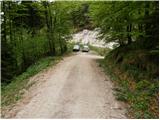
a) From the Ljubljana–Jesenice motorway, take the Kranj–east exit, then continue driving towards Jezersko. When arriving in Preddvor, leave the main road and continue left towards the centre of the mentioned place, from there follow the signs to the Bašelj settlement. When arriving in Bašelj, at the beginning of the left bend a narrower road continues straight ahead to the parking lot at the TD Bašelj log cabin (in descriptions starting point Bašelj), we however from the mentioned intersection continue along the main road for another good 100 m to the next intersection, where we continue right on the road towards Gamsov raj and the Laško hamlet. Just about 50 m further, continue on the left road, which gradually begins to climb moderately. At the Laško hamlet continue left again, then the asphalt ends and continue driving on the steep gravel road, which leads past the path junction (track) to the church of St. Lovrenc and Dom na Lovrencu. From the mentioned junction drive a little further to the end of the road or a small parking lot some 10 metres before.
b) From the Jesenice–Ljubljana motorway, take the Kranj–west exit and in the first intersection continue left. Continue through the underpass under the motorway, then arrive at the roundabout, from which continue driving towards Golnik. The route ahead leads through the Mlaka pri Kranju settlement, we at the end of the settlement continue right towards the Srakovlje settlement. Follows driving through Srakovlje, Spodnja Bela, Srednja Bela, Zgornja Bela (in Zgornja Bela join the road from Preddvor) to Bašelj, where the main road makes a long left bend, where a narrower road continues straight ahead to the parking lot at the TD Bašelj log cabin (in descriptions starting point Bašelj), we however from the mentioned intersection continue along the main road for another good 100 m to the next intersection, where we continue right on the road towards Gamsov raj and the Laško hamlet. Just about 50 m further, continue on the left road, which gradually begins to climb moderately. At the Laško hamlet continue left again, then the asphalt ends and continue driving on the steep gravel road, which leads past the path junction (track) to the church of St. Lovrenc and Dom na Lovrencu. From the mentioned junction drive a little further to the end of the road or a small parking lot some 10 metres before.
Route description:
From the small parking lot, walk to the turnaround at the end of the road. From the end of the road, continue left onto the track towards Kališče and Storžič. The track then climbs moderately along the bed of the Belica stream and after about 10 minutes splits into two parts. Continue on the left track, which ends after just a few metres. At this point, leave the proximity of the streambed and continue slightly left on the path, which steeply ascends through the forest. The steepness soon eases and the path leads us to the Košuta partisan hospital.
After the hospital, cross two consecutive gullies, then the path becomes steeper again. The path ahead continues through the forest, crossing a steeper slope where greater caution is needed when wet. Above the steep section, reach the side ridge of Kališče, where an unmarked path from Bašelj joins from the right.
Here continue left and continue the ascent on the still steep path, which proceeds through gradually sparser forest. After a bench and some views of nearby Storžič, the path turns right and returns to dense forest. A less steep path follows, which quickly takes us to the first hut on Spodnje Kališče. After the hut, the forest ends, then along a pleasant grassy surface in a few minutes reach the central part of the planina, where we also join the usual path from Mač.
From Spodnje Kališče continue slightly left towards Dom na Kališču, from which a few minutes of walking through the forest follow, then arrive at a nice viewpoint from which a beautiful view opens towards the nearby Dom na Kališču, Mali Grintovec, Lanež ridge, Krvavec... From the viewpoint, only a short ascent remains and we are at Dom na Kališču.
Starting point - Košuta partisan hospital 0:25, Košuta partisan hospital - Kisovec 0:25, Kisovec - Planina Kališče 0:45, Planina Kališče - Dom na Kališču 0:15.

Along the route: Partizanska bolnica Košuta (1016m), Kisovec (1152m),
Planina Kališče (1450m), Razpotje pod Kališčem (1455m)
Photos:
 1
1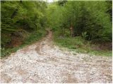 2
2 3
3 4
4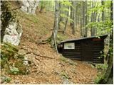 5
5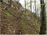 6
6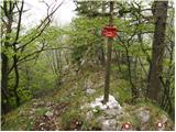 7
7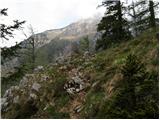 8
8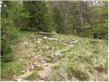 9
9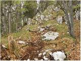 10
10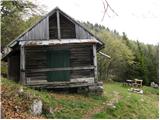 11
11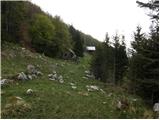 12
12 13
13 14
14 15
15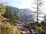 16
16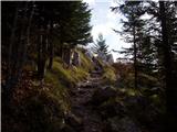 17
17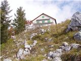 18
18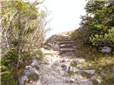 19
19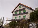 20
20
Discussion about the trip Laško (obračališče nad vasjo) - Dom na Kališču
|
| velkavrh7. 05. 2011 |
Today I walked this path for the first time on a tour to Storžič. I didn't see you Laško. The houses have house numbers Bašlja. The path is pleasant. It is well marked. It is even equipped with two steel cables at the most critical points. I think it is intended for winter hikes. The path rewards us with beautiful views of Storžič.
|
|
|
|
| Janiel7412. 01. 2012 |
Does anyone know how the snow conditions are on this path to the hut?
|
|
|
|
| sodnick12. 01. 2012 |
I was there on 2 January. A bit mixed. Mostly the path is dry, locally some snow and a bit icy. Many people use hiking crampons. The path from little Kališča (several small huts) to the hut is a real skating rink and without crampons quite tricky, but doable. Of course you don't follow the trail exactly. Otherwise there's little snow.
|
|
|
|
| Borut11. 09. 2014 |
I'm curious what the road is like at this time. Thanks.
|
|
|
|
| limona2. 09. 2014 |
The road is a bit eroded by water at one or two spots (when it climbs from the village into the forest), but it's fine to drive. Everyone who was up there on Saturday got there without issues. Cheers!
|
|
|
|
| jcerni27. 07. 2015 |
I'm wondering if the mountain path is passable due to the ice storm a few years ago. I want to go along it because I'll be walking the path of Karel and Žiga Zoisa.
|
|
|
|
| sodnick27. 07. 2015 |
The path was passable right after the ice storm (I walked it). A bit of dodging and climbing over a log, otherwise passable. I believe it's much better now, as this path is quite popular.
|
|
|
|
| claire24. 07. 2016 |
Very nicely marked path, commendable!
|
|
|
|
| Pelca27. 08. 2016 |
Starting point directions are wrong - in Bašelj go left, not right, towards signs for Gamsov raj. Road from Laško (not a village but an area, hence not marked) was so ripped up we barely drove the first bend with the car. Since we parked relatively far, it extended the hike by a good half hour. Trail to Dom na Kališču is really well marked and hut service is great. Good food and service.
|
|
|
|
| Kranj28. 08. 2016 |
Not wrong, you just took another path, also through Gamsov raj is excellently marked
|
|
|
|
| Pelca29. 08. 2016 |
No, this is that path (Laško) - which is LEFT from Bašelj, that's what it's about
|
|
|
|
| Pelca29. 08. 2016 |
You go right from Mač though.
|
|
|
|
| PUHIPUHI17. 04. 2018 |
Does anyone know what the current condition of the path to the described starting point is? Best regards; P
|
|
|
|
| Anansie19. 04. 2018 |
In January it was without peculiarities.
|
|
|
|
| Tajka6731. 10. 2024 19:13:44 |
The road to Gradišče parking lot for the first 250 meters is not suitable for ordinary vehicles, 4x4 is needed. Deep ditches, then ascent and gravel. Better leave the car below in the Laško hamlet. Otherwise, a wonderful sunny day for a nice hike, leaves slightly cover the markers, those on trees are well faded. In the hut the caretaker bakes such strudel that even I can't manage, crispy, full of delicious apples. Košuta Hospital is unfortunately closed 
|
|
|
|
| garmont1. 11. 2024 10:29:36 |
Below the village there is an arranged asphalt parking lot for about 10 vehicles. But this lower starting point really lengthens the trail…
|
|
|
To post a comment you must log in:
If you do not yet have a username, you must first
register.