Lago di Fedaia - Punta Penia (Marmolada) (Via ferrata Marmolada)
Starting point: Lago di Fedaia (2098 m)
| Latitude/Longitude: | 46,4574°N 11,8649°E |
| |
Route name: Via ferrata Marmolada
Walking time: 5 h
Difficulty: very difficult marked way
Via ferrata: B/C
Elevation gain: 1245 m
Elevation difference along the route: 1450 m
Map: Tabacco 7
Recommended equipment (summer): helmet, self belay set, ice axe, crampons
Recommended equipment (winter): helmet, self belay set, ice axe, crampons
Views: 33.768
 | 4 people like this post |
Access to starting point:
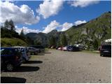
First, we drive to Cortina d'Ampezzo (to get here you can go via the border crossing at Rateče or Predel to Trbiž / Tarvisio and then on the highway in the direction of Udine to the exit Tolmezzo. From Tolmezzo we follow the road in the direction of the village Ampezzo and mountain pass Passo della Mauria. The road then descends and brings us to a crossroads, where we continue left (possible also right) in the direction of Cortina d'Ampezzo. At all following crossroads, we follow the signs for Cortina d'Ampezzo and then we follow the signs for the alpine pass Passo di Falzarego. Already in the first part of the ascent towards the pass Falzarego we will come to a crossroads, where the signs for pass Passo di Giau (2233 m) and Marmolada direct us to the left. The road after the pass Giau starts descending, and we follow it through the settlements in the lower part in the direction of Marmolada or pass Passo di Fedaia. The road, which then again starts ascending, brings us higher to the pass Fedaia, and we follow it to the other side of the lake, where we park on the parking lot near the hut Rifugio Castiglioni Marmolada.
Access from Primorska: We drive on the highway in the direction of Padova, but only to the highway junction, where we continue in the direction of Veneto and Belluno. Near Belluno the highway ends, and we follow the road ahead in the direction of Belluno, where at the larger crossroads we continue right in the direction of the town Agordo. From the mentioned town onwards we follow frequent signs for Marmolada or pass Passo di Fedaia. When we arrive at the mentioned pass we follow the road to the west side of the lake, where we turn left on the road which runs over the dam and then we park on the upper large parking lot.
Route description:
From the parking lot, we go on the path 606 following the signs “Punta Penia, Rif. Pian dei Fiacconi”. The path first ascends through rare dwarf pines and bushes a little left from the cableway, which runs towards the hut Pian dei Fiacconi. The path then brings us out of the dwarf pines and soon turns right and brings us to the west side of the cableway. Here the path starts ascending below the steep walls of the peak Col di Bousc (2494m) towards the south. Then follow a few ascents in zigzags and we are already at the saddle Col de Bous (2438m). At the saddle where there is a junction we continue left in the direction of the hut Pian dei Fiacconi.
Further, we ascend on rocky terrain towards the southeast. From the path by which we are ascending, wonderful views open up towards Marmolada and also towards the north where Piz Boé stands out. When we approach the cableway again, the path turns slightly right and to the hut where there are usually lots of people only a short undemanding ascent follows.
From the hut, we return a few meters back and at the junction we go on path 606 following the signs “Via Ferrata, Forcella Marmolada”. The path further for quite some time in a gentle descent crosses the slope towards the west. During the crossing the path descends approximately 200 elevation meters. During the descent we will cross a stream, and a little off the path we will also notice a small waterfall. The path then starts ascending again and turns left and brings us to the first quite flat snowfield. In the morning hours the snow is usually frozen, so crampons are already recommended here. After the first snowfield follows a short ascent on a poorly visible trail marked with cairns, then we start ascending a slightly steeper snowfield towards the notch Forcella Marmolada. The last few meters the snowfield is already quite steep and some caution is needed. From the end of the snowfield then follows a short ascent along the steel cable to the notch Forcella Marmolada, where the path from the south side joins.
At the notch we continue left and start ascending the steep slope with the aid of pegs. The path then turns slightly right and leads us briefly along the ridge, where a view opens to the south side. Further the path withdraws from the ridge a little to the left and then ascends for quite some time along the steel cable on numerous pegs and pitons. Such a path brings us back to a well-protected ridge along which we then ascend towards the east. In the last part the path becomes less steep and a short crossing of a flat snowfield follows. The snow here is usually already soft enough that crampons are not necessarily needed.
Follows a short undemanding ascent to the shelter, where from the left side the usual path over the glacier joins. From here we have only a few steps of easy walking to the highest peak of the Dolomites.

Photos:
 1
1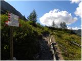 2
2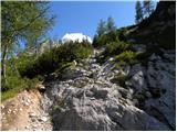 3
3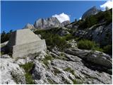 4
4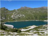 5
5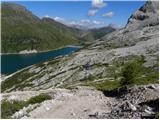 6
6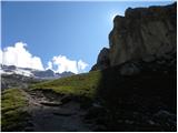 7
7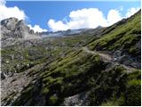 8
8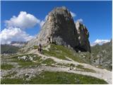 9
9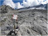 10
10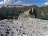 11
11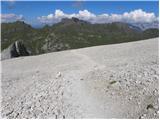 12
12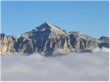 13
13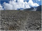 14
14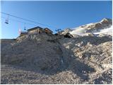 15
15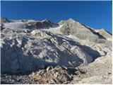 16
16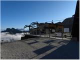 17
17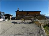 18
18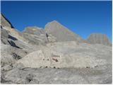 19
19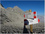 20
20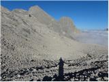 21
21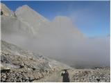 22
22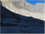 23
23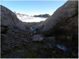 24
24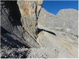 25
25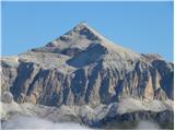 26
26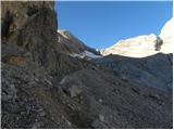 27
27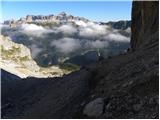 28
28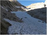 29
29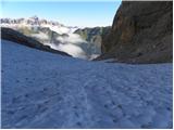 30
30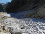 31
31 32
32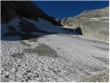 33
33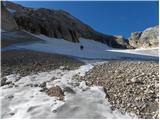 34
34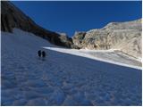 35
35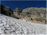 36
36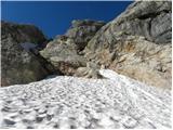 37
37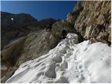 38
38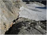 39
39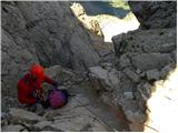 40
40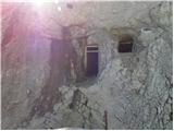 41
41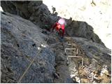 42
42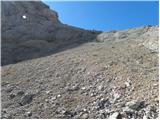 43
43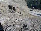 44
44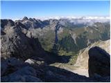 45
45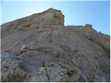 46
46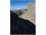 47
47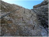 48
48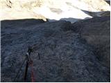 49
49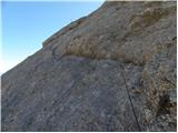 50
50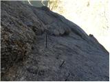 51
51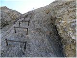 52
52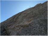 53
53 54
54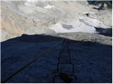 55
55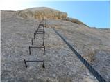 56
56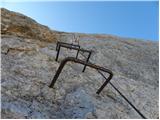 57
57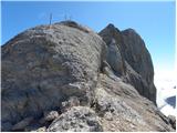 58
58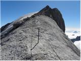 59
59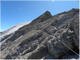 60
60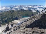 61
61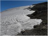 62
62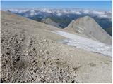 63
63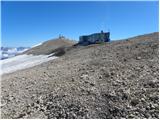 64
64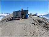 65
65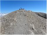 66
66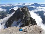 67
67 68
68
Discussion about the trip Lago di Fedaia - Punta Penia (Marmolada) (Via ferrata Marmolada)
|
| bdolmovi28. 05. 2010 |
Beautiful pictures and a wonderful tour to this high mountain. Congratulations to the author for such a nice presentation, Bojč.
|
|
|
|
| jedriličar3. 08. 2010 |
On Sunday, 01.08.2010 we made the ascent to Punta Penia via ferrata. Everything as described above. There was a bit of fresh snow so more caution was needed on the ferrata, it was slippery, and there was a crowd, we climbed in a line. The snow was quite soft, crampons mandatory otherwise slippery, but can be passed without difficulty. Ice axe not necessary but desirable, especially for descent on glacier. Weather was gorgeous, views around fantastic, especially to Piz Boe and Tre Cime. Time spent on ascent about 4 hours (due to crowd on ferrata couldn't go faster) from upper cable car station to summit. Descent via normale, so on glacier, path well trodden and no problems, safely bypasses crevasses. Crampons mandatory. Descent summit-upper cable car station about 1:30 h, then another 1 h to Lago Fedaia, total about 2:30 h. Advice to all: for ascent don't waste time in the morning, take the cable car (price 4.50 Eur one way) and save about 2 hours of climbing, and snow will be harder both for glacier ascent and approach to ferrata. Whoever really wants to do the path from the lake, descend it, like we did. And also: for sleeping there is one parking at Lago Fedaia near lower cable car station where campers park, tents can be pitched there, no one will bother or chase you. So you're right away in the morning on the first lift up. Lift officially from 9, but first one started already at 8. Gorgeous tour, not very demanding (of course with proper gear and knowledge), recommend to everyone to do it.
|
|
|
|
| Vedran2. 06. 2011 |
Very nicely presented and vividly described path, I think I'll head up there around 10.7. this year, you've helped me a lot with the information. Thanks 
|
|
|
|
| adry3. 09. 2015 |
On Friday 28.8. we enjoyed the opportunity of Marmolada in beautiful weather and magnificent views. The ferrata is well secured; we avoided the crowds so we were among the first on the cable car with baskets (€10 round trip), which unfortunately was delayed by well over half an hour (they were repairing it and started it after 9 o'clock). The most beautiful is the upper part of Marmolada, which is flat, steep and very spacious. At the top we met two guys from Gorenjska who ascended without the cable car (bravo).
The upper glacier is just right thawed; walking excellent. The notch to the lower glacier is well secured. The lower glacier in the middle is harder to access due to a considerable crevasse that you have to jump over. There's also quite a lot of sliding scree in the lower part of the glacier. Overall, an unforgettable day.
|
|
|
|
| enrique2. 09. 2018 |
Would anyone maybe go for a weekend in September to Marmolada? Company would be welcome..
|
|
|
|
| msle21. 08. 2019 |
Has anyone been on Marmolada via ferrata - conditions?
|
|
|
|
| trdi7720. 08. 2020 |
Does anyone have any information about PUNTA PENIA (Marmolada)?
What are the conditions like? Are there any crevasses on the glacier, perhaps some snow in the climbing section?
Best regards, Uroš
|
|
|
|
| A26. 08. 2020 |
Did the ascent last weekend. No crevasses, snowfield can be bypassed on the lower part, initial ferrata section slippery due to wet rocks onwards no problem. For descent over glacier, larger crevasses. Recommended to have rope for the last 3-4m drop onto glacier
|
|
|
|
| gorskilev8025. 09. 2025 14:13:38 |
On Saturday we did the ascent on this path. The glacier before entering the climbing section of the path is actually a "glacier" in the true sense of the word. In September, there's no more snow on it, just live ice and scree. Caution is needed when crossing and some ingenuity in finding the best passages.
Otherwise, the path is wonderful!
|
|
|
To post a comment you must log in:
If you do not yet have a username, you must first
register.