Krnica - Špik (via Lipnica)
Starting point: Krnica (1113 m)
Route name: via Lipnica
Walking time: 4 h
Difficulty: very difficult marked way
Elevation gain: 1359 m
Elevation difference along the route: 1600 m
Map: TNP
Recommended equipment (summer): helmet
Recommended equipment (winter): helmet, ice axe, crampons
Views: 52.115
 | 3 people like this post |
Access to starting point:
Leave the car immediately when turning from the main road towards Vršič, next to the Pišnica river, because the road to the Koča v Krnici hut is impassable in many places!
Route description:
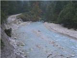
From the Koča v Krnici hut the previous path is destroyed due to rockfalls so you have to repeatedly climb over the rocks and persistently look for blazes! The path is very panoramic and very beautiful! Only the last hour becomes more demanding! Before the actual ascent on Špik of course you have to deal with the ridge, which is of course precipitous and crumbly therefore caution is not superfluous! Also at the last climb to the summit you have to be careful, because the stones are quite crumbly! Descent through Kačji graben and the scree before that are a separate chapter! Caution is needed at every step - scree is under a great slope, later the stones are slippery to the end! Most beautiful just before the end are small stream and later river Pišnica with very refreshing and clear water!
Photos:
 1
1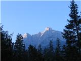 2
2 3
3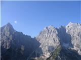 4
4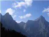 5
5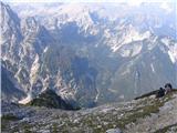 6
6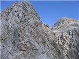 7
7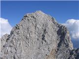 8
8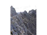 9
9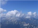 10
10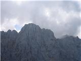 11
11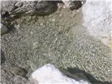 12
12
Discussion about the trip Krnica - Špik (via Lipnica)
|
| mukica23. 08. 2010 |
Did the path yesterday and as described a very nice panoramic tour to Špik, caution is advisable.When we arrived at Lipnica fog closed the summit, then it cleared a bit for some valley shots.Descent via Kačji greben to Pišnica.Nice tour 
|
|
|
|
| mukica23. 08. 2010 |
We also went via Gruntavica
|
|
|
|
| Sashita8. 09. 2010 |
On Sunday we're heading to Špik via Krnica, and I'm wondering if it really takes 4 hours as written here, or maybe 5? (info: we usually take less time than stated on these pages)
|
|
|
|
| Tadej8. 09. 2010 |
The description is in the "Other trips" section, where crossings, circular routes and the like are described. As you can see, the path start is stated at Koča v Krnici. To there you have about 1 hour of walking (depending on where you start).
http://www.hribi.net/gora/spik/1/43
|
|
|
|
| mukica8. 09. 2010 |
We two needed a little less than an hour from the bridge to the hut in Krnica, then 4 hours and 15 min further, usually we arrive at the summit earlier than stated on these pages. But it's true that in fine weather and even better views you have to stop several times to comment and admire. We two went to Prisank the day before and perhaps that's why we took a bit longer, we followed where and how it was the previous day on the other side of the valley
I wish you pleasant and safe hiking, especially on the descent over Kačji greben be careful as even when dry it's all slippery
|
|
|
|
| medicinka9. 09. 2010 |
On Saturday we're going to Špik. I hope it won't rain tomorrow either .and that it will at least dry a bit .and that it will at least dry a bit
|
|
|
|
| niki10. 09. 2010 |
On September 5th there was no stamp at Špik.
|
|
|
|
| lepenatka10. 09. 2010 |
Not in August either. They don't have it at the Koča in Krnica either, so some stamp the hut's stamp, the keeper signs.
I've had enough of that snake pit for a while
|
|
|
|
| medicinka11. 09. 2010 |
Beautiful weather on Špik. The stamp really isn't there, someone stole it or literally tore it out of the rock
So three from our group returned to Koča na Krnici (they say they knew there was no stamp there), the rest of us descended via Kačji greben It's really something else. At the end I had enough of all the slippery rocks and the difficult descent. But the wonderful view compensated for all the troubles of the ridge But the wonderful view compensated for all the troubles of the ridge
|
|
|
|
| medicinka12. 09. 2010 |
Yesterday I didn't read carefully that Lepenatka wrote that there is no Špik stamp in the hut. I have it
|
|
|
|
| klm12. 09. 2010 |
I have one extra impression of the Špik stamp. If anyone is interested, I'll sell it to them. Price negotiable...
|
|
|
|
| Bojan_A12. 09. 2010 |
Apparently just a photo is enough if you're doing the traverse.
Otherwise it's a nice and interesting mountain run.
|
|
|
|
| Kriška13. 09. 2010 |
Yesterday on the way back I stopped at the hut, they have the Špik stamp again.
|
|
|
|
| lepenatka13. 09. 2010 |
Some people have a special hobby, stealing stamps.
We informed the caretakers in Krnica that there is no stamp and the action has obviously started.
|
|
|
|
| Sashita13. 09. 2010 |
Yesterday we went to Špik. We couldn't have chosen a better day. Crazy! We have now designated this hike as our annual traditional one. I really warmly recommend it. It is true, however, that it is better to return the same way to the Koča in Krnica than sliding down the Kačji greben.
|
|
|
|
| enes12. 10. 2010 |
or does anyone know if you can get to Špik via gozd martuljka?
|
|
|
|
| biso13. 10. 2010 |
no problem. via north face.
that shouldn't be a problem, if grannies succeeded before WWII?
seriously though. are you messing around, or just provoking a bit.
for heaven's sake, open a map, then ask.
|
|
|
|
| enes13. 10. 2010 |
I don't know that part that's why I'm asking, I looked at the map and thought that once you get there you can go via gozd martuljka to the bivouac under Špik, I assume you can to Špik too...
|
|
|
|
| strelec195413. 10. 2010 |
enes In 1926 on the north side of Špik - "under the heart" the first ascent route was climbed by Mira Debelak with her partner.... in those times it was a great success and even today it is still an alpinistic domain that requires considerable knowledge and experience.
lp.
|
|
|
|
| enes13. 10. 2010 |
strelec thanks a lot for that information
|
|
|
|
| JusAvgustin13. 10. 2010 |
enes: via GM to Špik. not such a silly question at all. This answer might delight you, there are some "little hills" in between but that's even greater pleasure... We planned to do this tour this year with my buddy but the weather got ahead of us... In short, you start in GM, from GM you ascend to Kurji vrh 1762m a.s.l. from Kurji vrh you start the ridge traverse, first to Rigeljne, from Rigeljnov to Rigljica and Rušica 2074m a.s.l. from Rušica to Ruso peč 2108m a.s.l. from Ruse peči to the 2284m high Frdamane police and from Frdamanih polic along the NW ridge of Špik to the top.
the feat requires alpinistic knowledge and equipment, 2x60m ropes. This is our "mother of all ridges"
Lpp
|
|
|
|
| enes13. 10. 2010 |
geolog hello, well maybe someone who knows this part of the trail better will show up but is this the trail that strelec1954 described via the northern side or another one that you know?
|
|
|
|
| enes13. 10. 2010 |
anyway on Friday they're forecasting nice weather so you can try your luck again
|
|
|
|
| JusAvgustin13. 10. 2010 |
this is an ambitious ridge traverse from Kurji vrh to Špik. But it has several loops in between, one of them is a 50-meter abseil from the summit of Rušica to the col between Rušica and Rusa pečja, another thing is the climbing difficulty III-IV, the third catch is that descent options in a crisis are almost nonexistent... Yeah, on Friday I'm heading to those parts
Lpp
|
|
|
|
| enes14. 10. 2010 |
I'd really like to see where this goes and how you climb those rocks where you're going. is there any chance to join you at least until it becomes difficult to pass?
|
|
|
|
| enes14. 10. 2010 |
I've decided to go to Špik from the other side, but now something else interests me, I've found another trail that I think isn't described here namely via Kranjska Gora to Jezero Jasna then on foot further along that valley. well from there there are then two trails one direct to Špik the other via Koča na Krnici. is it possible someone has gone on this trail, had some experiences??
|
|
|
|
| enes14. 10. 2010 |
sorry this is the Kačji graben trail I was studying where it is and I've only now noticed it's this one, my mistake!
|
|
|
|
| sherpa14. 10. 2010 |
you really are one big mistake
you don't even know to Špik on the marked trail, yet you'd want to climb pathless Martuljek ridges
christ!
|
|
|
|
| enes14. 10. 2010 |
haha that's a good one
|
|
|
|
| JusAvgustin14. 10. 2010 |
no, I'm not taking you along, I have a constant climbing partner to whom I entrust my life, he entrusts his to me... that's how it is. Don't venture into the Martuljek wilderness without experience, you could pay dearly for it! Anyway I see you're enthusiastic about the "necklace". start slowly, then step up, no pathless terrain at all! First easy marked trails, then ascend step by step. If you've taken the advice well, then I'm pleased, if not then...
Juš
|
|
|
|
| enes14. 10. 2010 |
Yeah, of course I didn't mean to climb, I'm not really an alpinist with a "rope" and helmet. I thought the path is passable but somehow more demanding (you need stamina and shouldn't be afraid of heights etc.) that's why I inquired. Good thing there are people like you who understand and know how to advise. Otherwise I'll take your advice for good
|
|
|
|
| chackk28. 10. 2010 |
Can anyone tell me how much snow there is at the hut in Krnica? Is there any left at all now that the sun has shone a bit?
|
|
|
|
| IgorZlodej28. 10. 2010 |
The sun in this period shines only a little up to the hut in Krnica. Probably not much of it left.
|
|
|
|
| joste15. 09. 2011 |
Can anyone explain why the path is classified as "very difficult", but in the book Julijske Alpe (Mihelič 2009) it says: "Despite some exposed sections on the Lipnica ridge, the tour is not particularly demanding." The description here doesn't mention any fixed protection either... what condition are they in? Thanks for the info
|
|
|
|
| Lunatic15. 09. 2011 |
The path is quite demanding and exposed, the secured section is short but quite steep towards Lipnica, maybe a bit harder is the entry at the start of the securing, where there is steepness on both sides up to the entry into the wall , then more demanding is crossing the ridge from Lipnica to Špik, which is exposed and unsecured and requires some scrambling and caution. The last steep section also has some scrambling, which is actually harder downhill because of scree and gravel, depending on other visitors something occasionally flies down, so a helmet is recommended, last weekend I almost got hit by two stones about 3m away, triggered by ascending hikers and even a dog. I don't know how the dog got up this path
|
|
|
|
| joste15. 09. 2011 |
Lunatic thanks for the reply. Useful tips!
|
|
|
|
| JusAvgustin15. 09. 2011 |
lunatic wrote it so nicely that no guidebook writes it that nicely. But I can tell you how the dog got up there... Much easier than the owner
LPP p
|
|
|
|
| Ksandarela11. 08. 2016 |
Hello,
I'm interested if anyone knows whether the path to Špik via Lipnica is dry? Since Kredarica is snow-covered, so I can plan the route and equipment
|
|
|
To post a comment you must log in:
If you do not yet have a username, you must first
register.