Krma - Tosc (northern approach from Bohinjska vratca)
Starting point: Krma (946 m)
Route name: northern approach from Bohinjska vratca
Walking time: 5 h
Difficulty: partly demanding marked way, very difficult pathless terrain
Elevation gain: 1329 m
Elevation difference along the route: 1330 m
Map: Triglav 1:25000
Recommended equipment (summer): helmet
Recommended equipment (winter): helmet, ice axe, crampons
Views: 4.750
 | 11 people like this post |
Access to starting point:
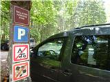
From Mojstrana in Gorenjska we drive into the Krma valley, where we turn onto the forest road towards Kovinarska koča, and from there further to the end of the road to the parking lot Pri Lesi, where there are already signs for Triglav National Park.
Route description:
At the end of the forest road or from the parking lot Pri Lesi, we begin our path first on a gentle road. The poorer road continues for some time over smaller scree fields, then it starts to rise gently and turns into a rocky cart track. When we cross a somewhat larger torrent, the path begins to ascend more steeply through denser forest. Higher up, out of the forest, the path enters a belt of dwarf pines mixed with scrub, and over the mentioned slope we ascend on scree interspersed with larger rocks. After a little less than an hour of walking, at an altitude of about 1400 m, the path flattens again and brings us to a nice grassy plain called Vrtača. On the other side of the plain, the path starts ascending again and after about 15 minutes of further walking brings us to Malo polje, where along the path in the middle of the plain among larger boulders we notice a junction, where cairns often stand; apart from faded inscriptions and blazes, there are unfortunately no other signs for Bohinjska vratca or Vodnikov dom, as the main marked path continues towards Triglav.
We continue on the narrow path to the left in the direction of Bohinjska vratca and Vodnikov dom. The little-trodden and poorly marked path starts to ascend gradually, first through sparse larch forest, then it brings us to a wide scree slope. The path upward over the scree becomes steeper and steeper and winds in numerous zigzags towards the saddle between Vernar and Tosc - called Bohinjska vratca. The last part of the path below the saddle is steeper and scree-covered, and due to the proximity of vertical walls below Vernar, there is an increased risk of falling rocks.
From Bohinjska vratca we turn left (right Vernar, down Vodnikov dom), towards the mighty wall of Tosc with wide and stepped ledges. Already after a few dozen meters we reach a quite demanding entry and steep approx. 8 m chimney (I-II), which fortunately has enough footholds and handholds to overcome successfully. Anyone who has too much trouble climbing here should not continue, as there are at least two more such demanding spots on the ascent, where one must climb over a shorter rocky step or rocky ledge.
The easiest ascent - is in the most optimal direction somehow triply twisted: up the first chimney, to the left over the rocky ledge, to the right over the rocky ledge, to the left over the rocky step, and then diagonally to the right over three smaller scree tongues and finally once more to the left along the shallow and scree-covered ridge all the way to the summit meadows (see picture). Some cairns are always placed there, but sometimes unfortunately not exactly in the right places, so for choosing the best direction one should always look ahead first rather than just follow them.
In general, the rocky step on the left side is steeper and more demanding for ascent, on the right side - looking upwards - less steep, but the terrain more ruined and scree-covered, constantly slipping and crumbling underfoot, so the risk of falling rocks is high, especially for any followers behind us. Therefore, we make good use of some intermediate green traverse bands to find upward passages. The crossings over rocky steps or ledges in the second half or continuation are no longer overly demanding and with good route choice do not exceed the difficulty of the first entry chimney; for those less experienced in climbing skills and orientation, accompaniment by a guide and occasional belaying is recommended, especially at crossings over any harder ledge.
Descent from the summit of Tosc is usually done via the normal approach and marked path that leads to it from the south side, but this path goes around to Vodnikov dom and then back to Bohinjska vratca – if returning to Krma – which is lengthy and very hot in summer.

Along the route: Bohinjska vratca (1979m)
Photos:
 1
1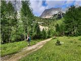 2
2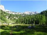 3
3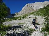 4
4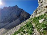 5
5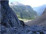 6
6 7
7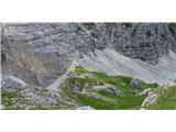 8
8 9
9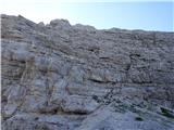 10
10 11
11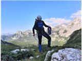 12
12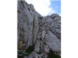 13
13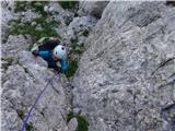 14
14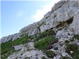 15
15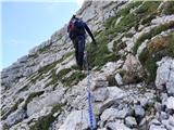 16
16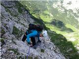 17
17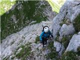 18
18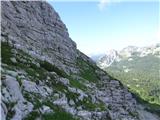 19
19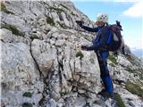 20
20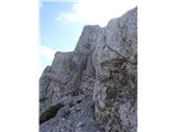 21
21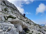 22
22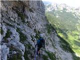 23
23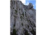 24
24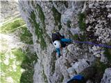 25
25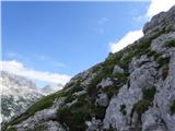 26
26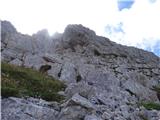 27
27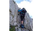 28
28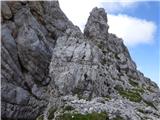 29
29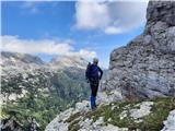 30
30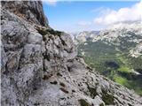 31
31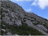 32
32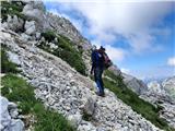 33
33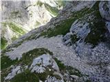 34
34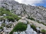 35
35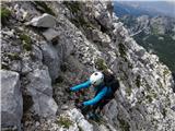 36
36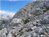 37
37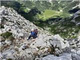 38
38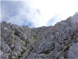 39
39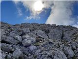 40
40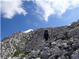 41
41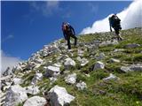 42
42 43
43 44
44
Discussion about the trip Krma - Tosc (northern approach from Bohinjska vratca)
|
| dprapr22. 08. 2022 19:19:26 |
My first off-trail descent. In my teenage years. Three of us, the youngest 16 years old. We said, it'll go down here, and it's even closer to the Voje valley. And it did, without any orientation issues.
We did the tour from Stara Fužina, via Uskovnica, Tosc, Kanjavec, L. Špičja, Komna, Bogatin, to Krn and back to Bohinj to the church. We didn't worry about where to park and for how much. 
|
|
|
|
| Daaam22. 08. 2022 19:38:02 |
My first off-trail that I did alone and according to the guide's difficult two. And since I'm of course not Drago, I descended the normal way. Repeated the tour two more times (the last time a huge rock broke loose under my colleague's feet, I was below and about half a meter off the line) there a bit above the second chimney. My hair stood on end as the mass rolled down the slope, my colleague already saw me under the cypresses. On the way home we knocked one back over the shoulder to appease the gods the warning about rockfall is very much in place the warning about rockfall is very much in place
|
|
|
|
| ppegan23. 08. 2022 08:52:03 |
Alyas, thanks for the description, it'll come in handy Approximately how long does it take to hike/climb from Bohinjske vrata to the summit? One hour?
|
|
|
|
| alyas23. 08. 2022 09:44:05 |
yes, when going for the first time - when you need to orient a bit and look around, it'll be closer to two hours than one, otherwise 1.30 is a realistic time uphill.
|
|
|
|
| ppegan23. 08. 2022 10:49:20 |
Ok. Thanks
|
|
|
|
| ljubitelj gora24. 08. 2022 12:30:47 |
For me it was better from Pokljuka, for Vernar from Krma.
|
|
|
|
| BorStenar20. 11. 2022 11:12:48 |
Hi
are there any technical difficulties if you only go to Bohinjskih vratc? what equipment is needed just to there?
LP thanks
|
|
|
|
| Janez Seliškar20. 11. 2022 12:40:04 |
BorStenar, when you look at the hiking map, you'll see that through Bohinjskih vratc there is a marked hiking trail! So, look and read everything about this trail.
|
|
|
|
| madeira24. 11. 2022 07:42:46 |
On hiking maps, the path from Krma to Bohinjska vrata is indeed shown as marked, but in reality it is no longer. The junction towards Bohinjska vrata is also marked only with a cairn. On the path to the vrata, some ancient markings may be visible, otherwise the path is marked with cairns. On the other side of Bohinjska vrata to Vodnikov dom, there are no problems with markings.
|
|
|
|
| docepe224. 11. 2022 10:01:15 |
I notified PZS about this in the summer and they replied that they would inform the maintainer. Shortly afterwards, a tender was published for a new maintainer of this path and a few nearby.
|
|
|
|
| BorStenar24. 11. 2022 20:39:55 |
So the path to Bohinjska Vratca from Veliko polje is marked for Krma, but from Krma the path there is marked only with cairns...
|
|
|
To post a comment you must log in:
If you do not yet have a username, you must first
register.